


Erik R. Nielsen
@eniels13.bsky.social
Colorado State Atmospheric Science Ph.D. '19 | Texas A&M Meteorology '13 | Studies concurrent, collocated tornado and flash flood events | San Antonio Spurs Fan
Reposted by Erik R. Nielsen
🚨 🚀 A crude interface I built to expose an archive of College of DuPage GOES imagery since about 15 Apr 2017. The archive is around ~500TB in size over ~2.5 billion JPEG images. Yikes, but here you go.
mesonet.agron.iastate.edu/archive/cods...
Anyways happy for feedback. Not worth the effort?
mesonet.agron.iastate.edu/archive/cods...
Anyways happy for feedback. Not worth the effort?
January 13, 2026 at 10:50 PM
🚨 🚀 A crude interface I built to expose an archive of College of DuPage GOES imagery since about 15 Apr 2017. The archive is around ~500TB in size over ~2.5 billion JPEG images. Yikes, but here you go.
mesonet.agron.iastate.edu/archive/cods...
Anyways happy for feedback. Not worth the effort?
mesonet.agron.iastate.edu/archive/cods...
Anyways happy for feedback. Not worth the effort?
Reposted by Erik R. Nielsen

Yesterday, Suomi-NPP passed over Tropical Cyclone Dudzai and its central eye.
January 13, 2026 at 6:37 PM
Yesterday, Suomi-NPP passed over Tropical Cyclone Dudzai and its central eye.
Reposted by Erik R. Nielsen

This was very fun to work on, emerging from student class projects a few years ago. How sharp can a cold front get? We were able to point to some answers.

It hasn't been cold this December, but 3 years ago it got cold in a hurry. Do you remember the cold front on December 21, 2022? It was extreme in all kinds of ways, which you can read about in this blog post.
Among the highlights: the temperature dropped almost 25°F in ten seconds in Akron! #cowx
Among the highlights: the temperature dropped almost 25°F in ten seconds in Akron! #cowx

A look back at the "big chill" from three years ago - Colorado Climate Blog
There hasn’t been much cold weather to speak of so far this winter in Colorado. [In case you missed it, here’s last week’s post with a look at those numbers, which are pretty bleak if you like winter....
climate.colostate.edu
December 23, 2025 at 4:44 PM
This was very fun to work on, emerging from student class projects a few years ago. How sharp can a cold front get? We were able to point to some answers.
Reposted by Erik R. Nielsen
This entire train got blown over this morning northwest of Cheyenne
December 19, 2025 at 5:49 PM
This entire train got blown over this morning northwest of Cheyenne
Reposted by Erik R. Nielsen
top 10 TDWR loop from that environment
November 24, 2025 at 10:13 PM
top 10 TDWR loop from that environment
Attached is a 1949UTC special sounding from College Station, TX. Balloon was launched between the initial round of storms and ahead of the main frontal boundary. There is some convective contamination between ~540mb and 450mb, as we hit an updraft at this point.

November 24, 2025 at 8:55 PM
Attached is a 1949UTC special sounding from College Station, TX. Balloon was launched between the initial round of storms and ahead of the main frontal boundary. There is some convective contamination between ~540mb and 450mb, as we hit an updraft at this point.
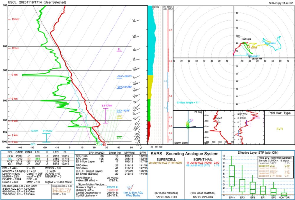
Below is a November 19th, 2025 1714 UTC special sounding launched as part of our ATMO-251 class from Texas A&M's campus. Sharppy image and sharppy file are attached. Mixed layer parcel is also plotted. Launch was done as morning stratus deck was clearing.
November 19, 2025 at 6:26 PM
Below is a November 19th, 2025 1714 UTC special sounding launched as part of our ATMO-251 class from Texas A&M's campus. Sharppy image and sharppy file are attached. Mixed layer parcel is also plotted. Launch was done as morning stratus deck was clearing.
Reposted by Erik R. Nielsen

Annotating a long 3+ day loop of #Hurricane #Melissa from Kingston, #Jamaica radar.
2️⃣ periods appear where an eyewall replacement cycle, #ERC, looked underway. In both cases, inner eyewall stayed intact & outer bands merged, resulting in a larger eye & strengthening after.
A remarkable evolution 🌀
2️⃣ periods appear where an eyewall replacement cycle, #ERC, looked underway. In both cases, inner eyewall stayed intact & outer bands merged, resulting in a larger eye & strengthening after.
A remarkable evolution 🌀
October 30, 2025 at 6:54 AM
Annotating a long 3+ day loop of #Hurricane #Melissa from Kingston, #Jamaica radar.
2️⃣ periods appear where an eyewall replacement cycle, #ERC, looked underway. In both cases, inner eyewall stayed intact & outer bands merged, resulting in a larger eye & strengthening after.
A remarkable evolution 🌀
2️⃣ periods appear where an eyewall replacement cycle, #ERC, looked underway. In both cases, inner eyewall stayed intact & outer bands merged, resulting in a larger eye & strengthening after.
A remarkable evolution 🌀
Reposted by Erik R. Nielsen

The Copernicus Sentinel-2 polar-orbiting satellite made an extremely fortuitous pass over Hurricane Melissa right before it made landfall in Jamaica to provide these stunning images of one of the most powerful Atlantic hurricanes in history

October 28, 2025 at 10:04 PM
The Copernicus Sentinel-2 polar-orbiting satellite made an extremely fortuitous pass over Hurricane Melissa right before it made landfall in Jamaica to provide these stunning images of one of the most powerful Atlantic hurricanes in history
Reposted by Erik R. Nielsen

I was worried for my crew mates when I saw them circling in the eye for over 20 mins. Looks like the very rough ride was confirmed. Plane had to leave early. They reported svr turb and a "sawtooth" eye. Looks like they moved 600-700ft up & down during this stretch in ~1 min.


October 28, 2025 at 4:23 PM
I was worried for my crew mates when I saw them circling in the eye for over 20 mins. Looks like the very rough ride was confirmed. Plane had to leave early. They reported svr turb and a "sawtooth" eye. Looks like they moved 600-700ft up & down during this stretch in ~1 min.
Reposted by Erik R. Nielsen
This has probably already been posted here, but Melissa has displayed a classic mesovortex pattern that can be modeled in the simplest 2D atmospheric models ("nondivergent barotropic models"). Here's a comparison of this morning's VIS sat and Kossin and Schubert (2001) experiments.


October 28, 2025 at 4:48 PM
This has probably already been posted here, but Melissa has displayed a classic mesovortex pattern that can be modeled in the simplest 2D atmospheric models ("nondivergent barotropic models"). Here's a comparison of this morning's VIS sat and Kossin and Schubert (2001) experiments.
Reposted by Erik R. Nielsen

Looking back at the rapid intensification of #Melissa, two things really stand out to me:
1) there were *5* consecutive six-hourly periods of RI
2) an RI period began when the storm was already at Category 4 intensity
The red entries here highlight when an RI period began (30+ kt in 24 hr).
1) there were *5* consecutive six-hourly periods of RI
2) an RI period began when the storm was already at Category 4 intensity
The red entries here highlight when an RI period began (30+ kt in 24 hr).

October 28, 2025 at 12:21 PM
Looking back at the rapid intensification of #Melissa, two things really stand out to me:
1) there were *5* consecutive six-hourly periods of RI
2) an RI period began when the storm was already at Category 4 intensity
The red entries here highlight when an RI period began (30+ kt in 24 hr).
1) there were *5* consecutive six-hourly periods of RI
2) an RI period began when the storm was already at Category 4 intensity
The red entries here highlight when an RI period began (30+ kt in 24 hr).
Reposted by Erik R. Nielsen

1-minute #GOES19/#GOESEast Visible and Infrared images with plots of GLM Flash Points showed prolific lightning activity within the inner eyewall of Category 5 Hurricane #Melissa as it approaches the SW coast of Jamaica. Low-altitude mesovortices persist within the eye.
October 28, 2025 at 2:32 PM
1-minute #GOES19/#GOESEast Visible and Infrared images with plots of GLM Flash Points showed prolific lightning activity within the inner eyewall of Category 5 Hurricane #Melissa as it approaches the SW coast of Jamaica. Low-altitude mesovortices persist within the eye.
Reposted by Erik R. Nielsen

A 10am EDT update from the National Hurricane Center now puts Melissa's sustained winds at 185 mph. Full text: www.nhc.noaa.gov/text/refresh...?
October 28, 2025 at 2:06 PM
A 10am EDT update from the National Hurricane Center now puts Melissa's sustained winds at 185 mph. Full text: www.nhc.noaa.gov/text/refresh...?
Reposted by Erik R. Nielsen

This is hands down the most extraordinary dropsonde in Atlantic recon history.

October 28, 2025 at 2:18 PM
This is hands down the most extraordinary dropsonde in Atlantic recon history.
Reposted by Erik R. Nielsen

The most recent recon data suggests that Melissa continues to intensify. Central pressure now down to 907 mb and a dropsonde released in the northeast eyewall measured a mean wind in the lower 150m of 185 knots (213 mph). This hurricane is truly in rarefied air as far as Atlantic hurricanes.

October 27, 2025 at 4:45 PM
The most recent recon data suggests that Melissa continues to intensify. Central pressure now down to 907 mb and a dropsonde released in the northeast eyewall measured a mean wind in the lower 150m of 185 knots (213 mph). This hurricane is truly in rarefied air as far as Atlantic hurricanes.
Reposted by Erik R. Nielsen

Here it is. The last 10 years of hail events across the U.S. using my prototype hail tracking algorithm!
Hoping to build out a more robust climatology of hailstorms like we have for tornadoes.
Hoping to build out a more robust climatology of hailstorms like we have for tornadoes.
October 6, 2025 at 4:33 PM
Here it is. The last 10 years of hail events across the U.S. using my prototype hail tracking algorithm!
Hoping to build out a more robust climatology of hailstorms like we have for tornadoes.
Hoping to build out a more robust climatology of hailstorms like we have for tornadoes.
Reposted by Erik R. Nielsen

Reposted by Erik R. Nielsen

“Those who can make you believe absurdities, can make you commit atrocities.” - Voltaire.
October 2, 2025 at 3:45 PM
“Those who can make you believe absurdities, can make you commit atrocities.” - Voltaire.
Reposted by Erik R. Nielsen
Here is a 4-day track summary of Hurricanes #Humberto and #Imelda, showcasing an example of the #Fujiwhara Effect. They approached and interacted with each other, coming within 465 miles, but did not complete an orbit around a common center or merge before moving back away from each other.
[1/4]
[1/4]

October 1, 2025 at 7:09 PM
Here is a 4-day track summary of Hurricanes #Humberto and #Imelda, showcasing an example of the #Fujiwhara Effect. They approached and interacted with each other, coming within 465 miles, but did not complete an orbit around a common center or merge before moving back away from each other.
[1/4]
[1/4]
Reposted by Erik R. Nielsen
The center of high pressure in the Southeast United States is revealed by dotted cumulus clouds in a circular pattern.
Areas of high pressure often dominate the broad atmospheric circulation in which clouds flow within. (2/3)
Areas of high pressure often dominate the broad atmospheric circulation in which clouds flow within. (2/3)

September 12, 2025 at 9:13 PM
The center of high pressure in the Southeast United States is revealed by dotted cumulus clouds in a circular pattern.
Areas of high pressure often dominate the broad atmospheric circulation in which clouds flow within. (2/3)
Areas of high pressure often dominate the broad atmospheric circulation in which clouds flow within. (2/3)
Reposted by Erik R. Nielsen

🚨 Recruiting Two PhD/MS Students 🚨
I am looking to bring on at least two GRAs (M.S. or Ph.D. Level) beginning Spring or Fall 2026 to join our CHAOS research group. Research projects will be related to artificial intelligence and machine learning applications for extreme temperatures and rainfall
I am looking to bring on at least two GRAs (M.S. or Ph.D. Level) beginning Spring or Fall 2026 to join our CHAOS research group. Research projects will be related to artificial intelligence and machine learning applications for extreme temperatures and rainfall
September 8, 2025 at 4:21 PM
🚨 Recruiting Two PhD/MS Students 🚨
I am looking to bring on at least two GRAs (M.S. or Ph.D. Level) beginning Spring or Fall 2026 to join our CHAOS research group. Research projects will be related to artificial intelligence and machine learning applications for extreme temperatures and rainfall
I am looking to bring on at least two GRAs (M.S. or Ph.D. Level) beginning Spring or Fall 2026 to join our CHAOS research group. Research projects will be related to artificial intelligence and machine learning applications for extreme temperatures and rainfall
Reposted by Erik R. Nielsen

Here’s a look at six new measures lawmakers just passed — and what these bills will do if Abbott signs them into law.

Sirens, summer camps and weather alerts: Here’s what is changing in Texas after the special session
When the governor called the Texas Legislature into special session after July’s historic floods, he topped his priority list with passing bills to better prepare the state for future natural…
www.texasstandard.org
September 5, 2025 at 2:45 PM
Here’s a look at six new measures lawmakers just passed — and what these bills will do if Abbott signs them into law.
Reposted by Erik R. Nielsen
NWS is hiring! Lead Meteorologist (Job Series - 1340) openings are now on USAJobs.gov. Use your science, technical, and communication skills to lead shifts, issue critical forecasts and warnings, and help protect lives and property. Apply today!
September 2, 2025 at 7:40 PM
NWS is hiring! Lead Meteorologist (Job Series - 1340) openings are now on USAJobs.gov. Use your science, technical, and communication skills to lead shifts, issue critical forecasts and warnings, and help protect lives and property. Apply today!