


Cameron Nixon
@cameronjnixon.bsky.social
I study storms and chase them
Co-founder of https://chasearchive.com/
Research scientist, Ph.D.
(severe storm environments and interactions)
Norman, OK
https://cameronjnixon.wordpress.com/
Co-founder of https://chasearchive.com/
Research scientist, Ph.D.
(severe storm environments and interactions)
Norman, OK
https://cameronjnixon.wordpress.com/
Pinned
Cameron Nixon
@cameronjnixon.bsky.social
· Feb 15
Storm Chase Archive - The Ultimate Catalog of Storm Chases
Explore the biggest storm chase collection on the web, featuring tornadoes, hurricanes, and awe-inspiring weather phenomena.
chasearchive.com
Chase archive @chasearchive.bsky.social
is now LIVE 🌪🌪
Come explore some of the greatest chases in the Great Plains chasearchive.com
is now LIVE 🌪🌪
Come explore some of the greatest chases in the Great Plains chasearchive.com
I was simply beam-ing when I took this last night
📍The Wichita Mountains, OK
📍The Wichita Mountains, OK

November 13, 2025 at 12:51 AM
I was simply beam-ing when I took this last night
📍The Wichita Mountains, OK
📍The Wichita Mountains, OK
8 months ago I had a vision: what if we had a unified, track-based dataset of all severe events?
Still a lot of improvements I can make to the algorithm itself, but otherwise, looks like we have one now. I can't wait to see what we can do with this 👀
Still a lot of improvements I can make to the algorithm itself, but otherwise, looks like we have one now. I can't wait to see what we can do with this 👀
November 7, 2025 at 7:42 PM
8 months ago I had a vision: what if we had a unified, track-based dataset of all severe events?
Still a lot of improvements I can make to the algorithm itself, but otherwise, looks like we have one now. I can't wait to see what we can do with this 👀
Still a lot of improvements I can make to the algorithm itself, but otherwise, looks like we have one now. I can't wait to see what we can do with this 👀
Tornado tracks by rating (left) and duration (right)
While highly rated/long-tracked tornadoes are biased towards the Southeast, long-duration tors are found even up to the High Plains.
Credit to @theasandmael.bsky.social for her incredible dataset!!
While highly rated/long-tracked tornadoes are biased towards the Southeast, long-duration tors are found even up to the High Plains.
Credit to @theasandmael.bsky.social for her incredible dataset!!


November 6, 2025 at 4:35 PM
Tornado tracks by rating (left) and duration (right)
While highly rated/long-tracked tornadoes are biased towards the Southeast, long-duration tors are found even up to the High Plains.
Credit to @theasandmael.bsky.social for her incredible dataset!!
While highly rated/long-tracked tornadoes are biased towards the Southeast, long-duration tors are found even up to the High Plains.
Credit to @theasandmael.bsky.social for her incredible dataset!!
Reposted by Cameron Nixon
I was going to wait until the shutdown was over but the cat is out if the bag. My first journal article is now live!
Convective Mode Classification and Distribution of Contiguous United States Tornado Events from 2003–2023 in: Weather and Forecasting - Ahead of print share.google/M3ty4pVs5Tld...
Convective Mode Classification and Distribution of Contiguous United States Tornado Events from 2003–2023 in: Weather and Forecasting - Ahead of print share.google/M3ty4pVs5Tld...

Convective Mode Classification and Distribution of Contiguous United States Tornado Events from 2003–2023
Abstract Tornadoes and severe thunderstorms represent a significant threat to life and property in the United States annually. Approximately one thousand tornadoes, two-hundred being significant (F/EF-2+), are documented on average every year. Using archived radar and Storm Data storm report information, 21 912 tornado grid hours were manually analyzed for convective mode from the years 2003–2023. This dataset builds upon prior work by Smith et al. (2012) (hereafter S12) by more than doubling the sample size to produce a robust, multidecadal climatology of tornadoes by convective mode. Comparisons were made between tornado samples spanning 2003–2011 and 2012–2023 to assess changes in the frequency and spatial occurrence of tornadoes. Convective mode characterization consisted of a subjective analysis of WSR-88D imagery into three categories: 1) supercell, 2) quasi–linear convective system (QLCS), and 3) disorganized. Spatial climatologies of the different modes were performed and Kernel Density Estimate plots of events per decade were generated as in S12. The highest climatological frequency for tornadic supercells is reaffirmed to extend from KS and OK east-southeastward to MS and AL, while QLCS tornadoes are more frequent from the northern Gulf Coast states into the lower Ohio River Valley. Comparing the new sample to the original, QLCS tornado relative frequency increased by over 100%. Substantial variation in QLCS tornado occurrence may be due to non-meteorological factors such as dual polarization radar and different observing/reporting practices.
share.google
November 5, 2025 at 3:18 PM
I was going to wait until the shutdown was over but the cat is out if the bag. My first journal article is now live!
Convective Mode Classification and Distribution of Contiguous United States Tornado Events from 2003–2023 in: Weather and Forecasting - Ahead of print share.google/M3ty4pVs5Tld...
Convective Mode Classification and Distribution of Contiguous United States Tornado Events from 2003–2023 in: Weather and Forecasting - Ahead of print share.google/M3ty4pVs5Tld...
Next up, wind swaths! 🌬💨
This was created solely using report clustering (no other gridded data). Plenty of events across the entire US, but can see the most intense storms from the Great Plains into the Midwest! 🟦
This was created solely using report clustering (no other gridded data). Plenty of events across the entire US, but can see the most intense storms from the Great Plains into the Midwest! 🟦

November 5, 2025 at 3:29 PM
Next up, wind swaths! 🌬💨
This was created solely using report clustering (no other gridded data). Plenty of events across the entire US, but can see the most intense storms from the Great Plains into the Midwest! 🟦
This was created solely using report clustering (no other gridded data). Plenty of events across the entire US, but can see the most intense storms from the Great Plains into the Midwest! 🟦
Ever wondered how hailstorms vary across the year? Here's all radar-estimated hail swaths by month since 2011. Love seeing the northwest flow monsters come alive June-August!
[MRMS MESH > .75", colored by max hail size]
[MRMS MESH > .75", colored by max hail size]
October 16, 2025 at 4:53 PM
Ever wondered how hailstorms vary across the year? Here's all radar-estimated hail swaths by month since 2011. Love seeing the northwest flow monsters come alive June-August!
[MRMS MESH > .75", colored by max hail size]
[MRMS MESH > .75", colored by max hail size]
Actual hail swaths per MRMS MESH >= .75", colored by measured hail size. I'm not sure when the world will be ready for this kind of data but it sure is sweet

October 14, 2025 at 4:19 PM
Actual hail swaths per MRMS MESH >= .75", colored by measured hail size. I'm not sure when the world will be ready for this kind of data but it sure is sweet
Here it is. The last 10 years of hail events across the U.S. using my prototype hail tracking algorithm!
Hoping to build out a more robust climatology of hailstorms like we have for tornadoes.
Hoping to build out a more robust climatology of hailstorms like we have for tornadoes.
October 6, 2025 at 4:33 PM
Here it is. The last 10 years of hail events across the U.S. using my prototype hail tracking algorithm!
Hoping to build out a more robust climatology of hailstorms like we have for tornadoes.
Hoping to build out a more robust climatology of hailstorms like we have for tornadoes.
A rarity for the northern plains: 22 tornado reports but only 1 hail report. This tracks with the evident tropical-like near-MCV environment: warm and nearly saturated low-levels with deep inflow layers and surface-based buoyancy are rarely favorable for severe hail.


September 15, 2025 at 1:25 AM
A rarity for the northern plains: 22 tornado reports but only 1 hail report. This tracks with the evident tropical-like near-MCV environment: warm and nearly saturated low-levels with deep inflow layers and surface-based buoyancy are rarely favorable for severe hail.
This is wild. Reminds me of the convective mode I've observed when a hurricane eye contracts so tightly that it's effectively a supercell.
September 14, 2025 at 10:52 PM
This is wild. Reminds me of the convective mode I've observed when a hurricane eye contracts so tightly that it's effectively a supercell.
When I'm not chasing or rockhounding, I'm gathering vintage things and "nature knick-knacks" for my home. Really loving how my living room is coming along lately!
(yes, that's a tumbleweed lol)
(yes, that's a tumbleweed lol)

August 24, 2025 at 10:05 PM
When I'm not chasing or rockhounding, I'm gathering vintage things and "nature knick-knacks" for my home. Really loving how my living room is coming along lately!
(yes, that's a tumbleweed lol)
(yes, that's a tumbleweed lol)
Some preliminary output from the hail tracker!! Look at all those tracks. Also pay close attention to all the potential tracks that went un-reported (grey). Pretty stoked to even imagine this as a future operational product.

August 22, 2025 at 5:21 PM
Some preliminary output from the hail tracker!! Look at all those tracks. Also pay close attention to all the potential tracks that went un-reported (grey). Pretty stoked to even imagine this as a future operational product.
Been a minute since I've been on here, but I've been hard at work. Here's a hail algorithm I developed that strings together reports and MESH data into "events" (colored swaths), in order to fill in the gaps and give more info about each event (duration, areal coverage, storm motion, etc.)

August 6, 2025 at 9:41 PM
Been a minute since I've been on here, but I've been hard at work. Here's a hail algorithm I developed that strings together reports and MESH data into "events" (colored swaths), in order to fill in the gaps and give more info about each event (duration, areal coverage, storm motion, etc.)
Neat shot from yesterday's Newcastle tornado as it took on a bent-back "boomerang" shape
My hypothesis is that the vortex tilted forward due to intense forward momentum when undercut by the colliding squall line, while frictional effects slowed this momentum near the ground.
My hypothesis is that the vortex tilted forward due to intense forward momentum when undercut by the colliding squall line, while frictional effects slowed this momentum near the ground.

June 4, 2025 at 5:26 PM
Neat shot from yesterday's Newcastle tornado as it took on a bent-back "boomerang" shape
My hypothesis is that the vortex tilted forward due to intense forward momentum when undercut by the colliding squall line, while frictional effects slowed this momentum near the ground.
My hypothesis is that the vortex tilted forward due to intense forward momentum when undercut by the colliding squall line, while frictional effects slowed this momentum near the ground.
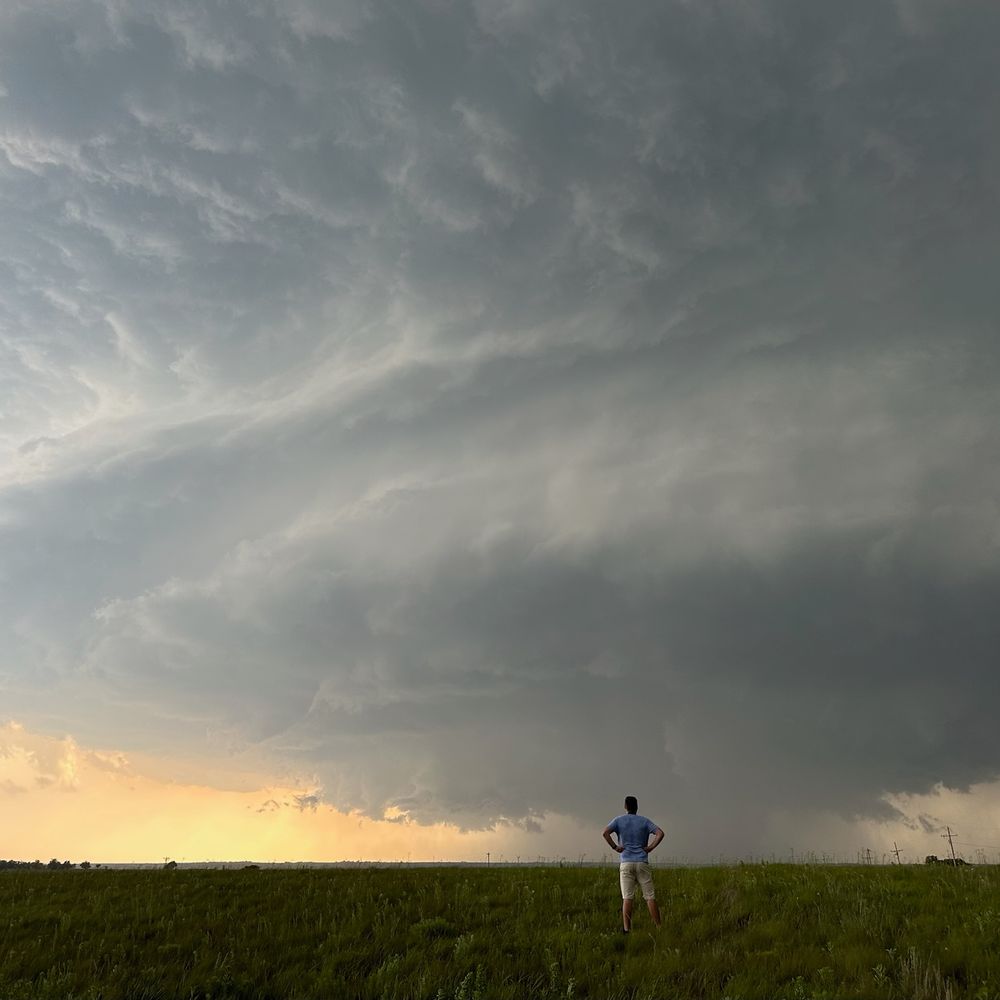
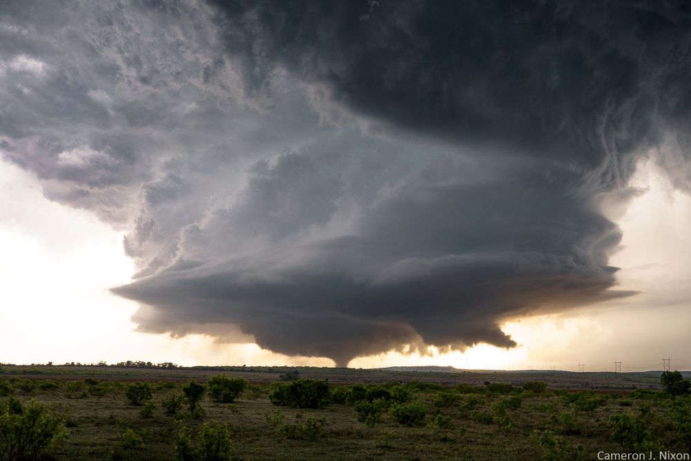
Tornado towers over Arnett, OK

May 21, 2025 at 2:59 AM
Tornado towers over Arnett, OK
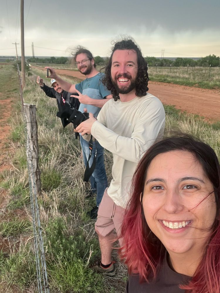
Today I achieved my dream of showing my mom my passion, and giving her the experience. Mad props to my buddy Jonny for this shot

May 19, 2025 at 4:20 AM
Today I achieved my dream of showing my mom my passion, and giving her the experience. Mad props to my buddy Jonny for this shot
Interesting day with many discrete storms producing only occasional tornadoes, which rapidly occlude and rope out into the rear flank. This may be a symptom of excessive low-level storm-relative flow and a general absence of rear-flank nudgers/mergers to prevent occlusion.
May 16, 2025 at 11:17 PM
Interesting day with many discrete storms producing only occasional tornadoes, which rapidly occlude and rope out into the rear flank. This may be a symptom of excessive low-level storm-relative flow and a general absence of rear-flank nudgers/mergers to prevent occlusion.
I love May. Not only does the sky come alive, but so does my community. Old friends, new friends, the sharing of thoughts and the inspiration of new ideas. It always feels like a warm reunion, and a reminder that my life is so cool ❤️


May 15, 2025 at 10:12 PM
I love May. Not only does the sky come alive, but so does my community. Old friends, new friends, the sharing of thoughts and the inspiration of new ideas. It always feels like a warm reunion, and a reminder that my life is so cool ❤️
Reposted by Cameron Nixon

Did someone say “cell mergers”? @cameronjnixon.bsky.social
May 15, 2025 at 8:22 PM
Did someone say “cell mergers”? @cameronjnixon.bsky.social
Reposted by Cameron Nixon

Comparison of yesterday's automated DAY2 outlook (18Z run) generated by our ML models with today's SPC forecast from @wxliz.bsky.social.


May 15, 2025 at 6:36 PM
Comparison of yesterday's automated DAY2 outlook (18Z run) generated by our ML models with today's SPC forecast from @wxliz.bsky.social.
Reposted by Cameron Nixon

Here a quick time lapse of the first 20 or so minutes of the Matador,TX tornado the other day. I love how the tornado carouseled around the meso multiple times!
youtu.be/O5S9Hqkkinw?...
youtu.be/O5S9Hqkkinw?...
4-24-25 Matador long-track tornado
YouTube video by Alex Schueth
youtu.be
May 4, 2025 at 3:50 PM
Here a quick time lapse of the first 20 or so minutes of the Matador,TX tornado the other day. I love how the tornado carouseled around the meso multiple times!
youtu.be/O5S9Hqkkinw?...
youtu.be/O5S9Hqkkinw?...
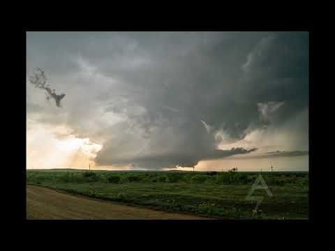
My "the shot" from the Matador, TX tornado
May 2, 2025 at 9:33 PM
My "the shot" from the Matador, TX tornado
As some of y'all have noticed, I've finally uploaded my storm interactions and "nudgers" talks for your viewing pleasure! :)
youtu.be/1qLhFadlqS0?...
youtu.be/1qLhFadlqS0?...

April 30, 2025 at 11:28 PM
As some of y'all have noticed, I've finally uploaded my storm interactions and "nudgers" talks for your viewing pleasure! :)
youtu.be/1qLhFadlqS0?...
youtu.be/1qLhFadlqS0?...
Ah yes here come our nightly evening activities

April 30, 2025 at 1:05 AM
Ah yes here come our nightly evening activities
Beautiful example of a supercell undergoing discrete upshear propagation towards its initiating boundary
This can induce highly deviant motion and significant precipitation ventilation, resulting in an "elongated" appearance on radar.
This can induce highly deviant motion and significant precipitation ventilation, resulting in an "elongated" appearance on radar.
April 29, 2025 at 8:21 PM
Beautiful example of a supercell undergoing discrete upshear propagation towards its initiating boundary
This can induce highly deviant motion and significant precipitation ventilation, resulting in an "elongated" appearance on radar.
This can induce highly deviant motion and significant precipitation ventilation, resulting in an "elongated" appearance on radar.