


Cameron Nixon
@cameronjnixon.bsky.social
I study storms and chase them
Co-founder of https://chasearchive.com/
Research scientist, Ph.D.
(severe storm environments and interactions)
Norman, OK
https://cameronjnixon.wordpress.com/
Co-founder of https://chasearchive.com/
Research scientist, Ph.D.
(severe storm environments and interactions)
Norman, OK
https://cameronjnixon.wordpress.com/
Ever feel like your town gets more nighttime tornadoes than others?
Here's a map of tornadoes by time of day (nighttime tors are plotted on top of daytime tors to stand out). I feel for you Tulsa, Jackson, Birmingham, Nashville...
Here's a map of tornadoes by time of day (nighttime tors are plotted on top of daytime tors to stand out). I feel for you Tulsa, Jackson, Birmingham, Nashville...

November 20, 2025 at 7:56 PM
Ever feel like your town gets more nighttime tornadoes than others?
Here's a map of tornadoes by time of day (nighttime tors are plotted on top of daytime tors to stand out). I feel for you Tulsa, Jackson, Birmingham, Nashville...
Here's a map of tornadoes by time of day (nighttime tors are plotted on top of daytime tors to stand out). I feel for you Tulsa, Jackson, Birmingham, Nashville...
Fantastic example of hail doing what it wants
(Preferentially produced by elevated supercells north of the greatest perceived risk, even though both targets featured supercells)
(Preferentially produced by elevated supercells north of the greatest perceived risk, even though both targets featured supercells)
November 19, 2025 at 12:00 AM
Fantastic example of hail doing what it wants
(Preferentially produced by elevated supercells north of the greatest perceived risk, even though both targets featured supercells)
(Preferentially produced by elevated supercells north of the greatest perceived risk, even though both targets featured supercells)
I was simply beam-ing when I took this last night
📍The Wichita Mountains, OK
📍The Wichita Mountains, OK

November 13, 2025 at 12:51 AM
I was simply beam-ing when I took this last night
📍The Wichita Mountains, OK
📍The Wichita Mountains, OK
8 months ago I had a vision: what if we had a unified, track-based dataset of all severe events?
Still a lot of improvements I can make to the algorithm itself, but otherwise, looks like we have one now. I can't wait to see what we can do with this 👀
Still a lot of improvements I can make to the algorithm itself, but otherwise, looks like we have one now. I can't wait to see what we can do with this 👀
November 7, 2025 at 7:42 PM
8 months ago I had a vision: what if we had a unified, track-based dataset of all severe events?
Still a lot of improvements I can make to the algorithm itself, but otherwise, looks like we have one now. I can't wait to see what we can do with this 👀
Still a lot of improvements I can make to the algorithm itself, but otherwise, looks like we have one now. I can't wait to see what we can do with this 👀
Tornado tracks by rating (left) and duration (right)
While highly rated/long-tracked tornadoes are biased towards the Southeast, long-duration tors are found even up to the High Plains.
Credit to @theasandmael.bsky.social for her incredible dataset!!
While highly rated/long-tracked tornadoes are biased towards the Southeast, long-duration tors are found even up to the High Plains.
Credit to @theasandmael.bsky.social for her incredible dataset!!


November 6, 2025 at 4:35 PM
Tornado tracks by rating (left) and duration (right)
While highly rated/long-tracked tornadoes are biased towards the Southeast, long-duration tors are found even up to the High Plains.
Credit to @theasandmael.bsky.social for her incredible dataset!!
While highly rated/long-tracked tornadoes are biased towards the Southeast, long-duration tors are found even up to the High Plains.
Credit to @theasandmael.bsky.social for her incredible dataset!!

Next up, wind swaths! 🌬💨
This was created solely using report clustering (no other gridded data). Plenty of events across the entire US, but can see the most intense storms from the Great Plains into the Midwest! 🟦
This was created solely using report clustering (no other gridded data). Plenty of events across the entire US, but can see the most intense storms from the Great Plains into the Midwest! 🟦

November 5, 2025 at 3:29 PM
Next up, wind swaths! 🌬💨
This was created solely using report clustering (no other gridded data). Plenty of events across the entire US, but can see the most intense storms from the Great Plains into the Midwest! 🟦
This was created solely using report clustering (no other gridded data). Plenty of events across the entire US, but can see the most intense storms from the Great Plains into the Midwest! 🟦
Ever wondered how hailstorms vary across the year? Here's all radar-estimated hail swaths by month since 2011. Love seeing the northwest flow monsters come alive June-August!
[MRMS MESH > .75", colored by max hail size]
[MRMS MESH > .75", colored by max hail size]
October 16, 2025 at 4:53 PM
Ever wondered how hailstorms vary across the year? Here's all radar-estimated hail swaths by month since 2011. Love seeing the northwest flow monsters come alive June-August!
[MRMS MESH > .75", colored by max hail size]
[MRMS MESH > .75", colored by max hail size]
Actual hail swaths per MRMS MESH >= .75", colored by measured hail size. I'm not sure when the world will be ready for this kind of data but it sure is sweet

October 14, 2025 at 4:19 PM
Actual hail swaths per MRMS MESH >= .75", colored by measured hail size. I'm not sure when the world will be ready for this kind of data but it sure is sweet
🤣Just for you, here's the whole West Coast and intermountain west!! Several nice swaths in there, many unreported

October 7, 2025 at 2:44 PM
🤣Just for you, here's the whole West Coast and intermountain west!! Several nice swaths in there, many unreported
Some insights:
- High Plains are king (but things tame a bit near the mountains)
- Southeast struggles with swaths
- northwest flow is king (most noteworthy hail tracks move NW-to-SE, unlike tornadoes)
- still some significant reporting gaps (esp. SE NM into SW TX)
- High Plains are king (but things tame a bit near the mountains)
- Southeast struggles with swaths
- northwest flow is king (most noteworthy hail tracks move NW-to-SE, unlike tornadoes)
- still some significant reporting gaps (esp. SE NM into SW TX)

October 6, 2025 at 4:33 PM
Some insights:
- High Plains are king (but things tame a bit near the mountains)
- Southeast struggles with swaths
- northwest flow is king (most noteworthy hail tracks move NW-to-SE, unlike tornadoes)
- still some significant reporting gaps (esp. SE NM into SW TX)
- High Plains are king (but things tame a bit near the mountains)
- Southeast struggles with swaths
- northwest flow is king (most noteworthy hail tracks move NW-to-SE, unlike tornadoes)
- still some significant reporting gaps (esp. SE NM into SW TX)
Here it is. The last 10 years of hail events across the U.S. using my prototype hail tracking algorithm!
Hoping to build out a more robust climatology of hailstorms like we have for tornadoes.
Hoping to build out a more robust climatology of hailstorms like we have for tornadoes.
October 6, 2025 at 4:33 PM
Here it is. The last 10 years of hail events across the U.S. using my prototype hail tracking algorithm!
Hoping to build out a more robust climatology of hailstorms like we have for tornadoes.
Hoping to build out a more robust climatology of hailstorms like we have for tornadoes.
A rarity for the northern plains: 22 tornado reports but only 1 hail report. This tracks with the evident tropical-like near-MCV environment: warm and nearly saturated low-levels with deep inflow layers and surface-based buoyancy are rarely favorable for severe hail.


September 15, 2025 at 1:25 AM
A rarity for the northern plains: 22 tornado reports but only 1 hail report. This tracks with the evident tropical-like near-MCV environment: warm and nearly saturated low-levels with deep inflow layers and surface-based buoyancy are rarely favorable for severe hail.
This is wild. Reminds me of the convective mode I've observed when a hurricane eye contracts so tightly that it's effectively a supercell.
September 14, 2025 at 10:52 PM
This is wild. Reminds me of the convective mode I've observed when a hurricane eye contracts so tightly that it's effectively a supercell.
When I'm not chasing or rockhounding, I'm gathering vintage things and "nature knick-knacks" for my home. Really loving how my living room is coming along lately!
(yes, that's a tumbleweed lol)
(yes, that's a tumbleweed lol)

August 24, 2025 at 10:05 PM
When I'm not chasing or rockhounding, I'm gathering vintage things and "nature knick-knacks" for my home. Really loving how my living room is coming along lately!
(yes, that's a tumbleweed lol)
(yes, that's a tumbleweed lol)
Some preliminary output from the hail tracker!! Look at all those tracks. Also pay close attention to all the potential tracks that went un-reported (grey). Pretty stoked to even imagine this as a future operational product.

August 22, 2025 at 5:21 PM
Some preliminary output from the hail tracker!! Look at all those tracks. Also pay close attention to all the potential tracks that went un-reported (grey). Pretty stoked to even imagine this as a future operational product.
Been a minute since I've been on here, but I've been hard at work. Here's a hail algorithm I developed that strings together reports and MESH data into "events" (colored swaths), in order to fill in the gaps and give more info about each event (duration, areal coverage, storm motion, etc.)

August 6, 2025 at 9:41 PM
Been a minute since I've been on here, but I've been hard at work. Here's a hail algorithm I developed that strings together reports and MESH data into "events" (colored swaths), in order to fill in the gaps and give more info about each event (duration, areal coverage, storm motion, etc.)
Neat shot from yesterday's Newcastle tornado as it took on a bent-back "boomerang" shape
My hypothesis is that the vortex tilted forward due to intense forward momentum when undercut by the colliding squall line, while frictional effects slowed this momentum near the ground.
My hypothesis is that the vortex tilted forward due to intense forward momentum when undercut by the colliding squall line, while frictional effects slowed this momentum near the ground.

June 4, 2025 at 5:26 PM
Neat shot from yesterday's Newcastle tornado as it took on a bent-back "boomerang" shape
My hypothesis is that the vortex tilted forward due to intense forward momentum when undercut by the colliding squall line, while frictional effects slowed this momentum near the ground.
My hypothesis is that the vortex tilted forward due to intense forward momentum when undercut by the colliding squall line, while frictional effects slowed this momentum near the ground.
Tornado towers over Arnett, OK

May 21, 2025 at 2:59 AM
Tornado towers over Arnett, OK
Today I achieved my dream of showing my mom my passion, and giving her the experience. Mad props to my buddy Jonny for this shot

May 19, 2025 at 4:20 AM
Today I achieved my dream of showing my mom my passion, and giving her the experience. Mad props to my buddy Jonny for this shot
Interesting day with many discrete storms producing only occasional tornadoes, which rapidly occlude and rope out into the rear flank. This may be a symptom of excessive low-level storm-relative flow and a general absence of rear-flank nudgers/mergers to prevent occlusion.
May 16, 2025 at 11:17 PM
Interesting day with many discrete storms producing only occasional tornadoes, which rapidly occlude and rope out into the rear flank. This may be a symptom of excessive low-level storm-relative flow and a general absence of rear-flank nudgers/mergers to prevent occlusion.
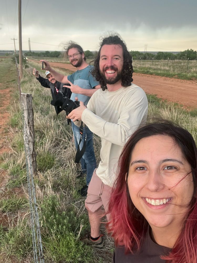
I love May. Not only does the sky come alive, but so does my community. Old friends, new friends, the sharing of thoughts and the inspiration of new ideas. It always feels like a warm reunion, and a reminder that my life is so cool ❤️


May 15, 2025 at 10:12 PM
I love May. Not only does the sky come alive, but so does my community. Old friends, new friends, the sharing of thoughts and the inspiration of new ideas. It always feels like a warm reunion, and a reminder that my life is so cool ❤️
My "the shot" from the Matador, TX tornado
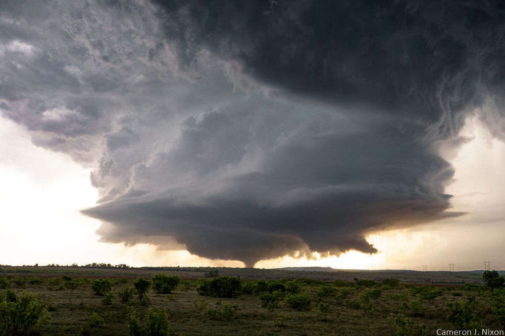
May 2, 2025 at 9:33 PM
My "the shot" from the Matador, TX tornado
As some of y'all have noticed, I've finally uploaded my storm interactions and "nudgers" talks for your viewing pleasure! :)
youtu.be/1qLhFadlqS0?...
youtu.be/1qLhFadlqS0?...

April 30, 2025 at 11:28 PM
As some of y'all have noticed, I've finally uploaded my storm interactions and "nudgers" talks for your viewing pleasure! :)
youtu.be/1qLhFadlqS0?...
youtu.be/1qLhFadlqS0?...
Ah yes here come our nightly evening activities

April 30, 2025 at 1:05 AM
Ah yes here come our nightly evening activities