


Philippe Papin
@pppapin.bsky.social
Sr. Hurricane Specialist at NHC 🌀 | Ph.D + M.S. via UAlbany & B.S. via UNCA | Enjoy all kinds of weather 🌤❄️⛈🌪| Thoughts are my own
Reposted by Philippe Papin

Here is the latest update from WPC on the California atmospheric river event where a moderate to high risk of flash flooding is anticipated for southern California on Wednesday Christmas Eve. Please stay safe through the upcoming Christmas holiday.
www.wpc.ncep.noaa.gov/key_messages...
www.wpc.ncep.noaa.gov/key_messages...

December 23, 2025 at 10:04 PM
Here is the latest update from WPC on the California atmospheric river event where a moderate to high risk of flash flooding is anticipated for southern California on Wednesday Christmas Eve. Please stay safe through the upcoming Christmas holiday.
www.wpc.ncep.noaa.gov/key_messages...
www.wpc.ncep.noaa.gov/key_messages...
Reposted by Philippe Papin
Unseasonable warmth is forecast across a large portion of the Lower 48 this week. High temps will soar to 30-40 degrees above normal, with some areas as much as 50 degrees above normal. Dozens of daily temp records could be broken.
How warm will it be where you live this week? Check weather.gov.
How warm will it be where you live this week? Check weather.gov.
December 23, 2025 at 6:15 PM
Unseasonable warmth is forecast across a large portion of the Lower 48 this week. High temps will soar to 30-40 degrees above normal, with some areas as much as 50 degrees above normal. Dozens of daily temp records could be broken.
How warm will it be where you live this week? Check weather.gov.
How warm will it be where you live this week? Check weather.gov.
Reposted by Philippe Papin
Wildfires can spread quickly — by the time one is nearby, you may not have much time. Have an evacuation plan, and prepare an emergency supply kit ahead of time. Listen to local officials for emergency information and any evacuation orders.

December 19, 2025 at 12:16 PM
Wildfires can spread quickly — by the time one is nearby, you may not have much time. Have an evacuation plan, and prepare an emergency supply kit ahead of time. Listen to local officials for emergency information and any evacuation orders.
Reposted by Philippe Papin
❄️ D.C.'s first measurable snow of the season covers the capital in a hush of flurries. Winter is making a return with cooler than normal temperatures in the forecast for the next several days.
Stay up to date with the latest forecast at weather.gov.
Credit: Bob Hyatt, NWS
Stay up to date with the latest forecast at weather.gov.
Credit: Bob Hyatt, NWS
December 5, 2025 at 4:13 PM
❄️ D.C.'s first measurable snow of the season covers the capital in a hush of flurries. Winter is making a return with cooler than normal temperatures in the forecast for the next several days.
Stay up to date with the latest forecast at weather.gov.
Credit: Bob Hyatt, NWS
Stay up to date with the latest forecast at weather.gov.
Credit: Bob Hyatt, NWS
Reposted by Philippe Papin

Persistent fog and low stratus clouds have been plaguing California's Central Valley for the last week.
December 1, 2025 at 9:03 PM
Persistent fog and low stratus clouds have been plaguing California's Central Valley for the last week.
Reposted by Philippe Papin

December is the coldest month of the year for most areas from the Rocky Mountains to the Pacific Ocean.

December 1, 2025 at 7:10 PM
December is the coldest month of the year for most areas from the Rocky Mountains to the Pacific Ocean.
Reposted by Philippe Papin

11/30: Today is the last day of the 2025 hurricane season. The month of November has proven to be very quiet this year, with no named storms during the month. There weren't even any disturbances mentioned in the Tropical Weather Outlook the en... https://x.com/NHC_Atlantic/status/1995096242884358356

November 30, 2025 at 11:44 AM
11/30: Today is the last day of the 2025 hurricane season. The month of November has proven to be very quiet this year, with no named storms during the month. There weren't even any disturbances mentioned in the Tropical Weather Outlook the en... https://x.com/NHC_Atlantic/status/1995096242884358356
Impressed with the resilience of #Senyar… looks like a coherent circulation may have made it across #Malaysia. Nice radar coverage showing the last 24h revolution as it crossed from the Malacca Strait ➡️ South China Sea.
Imagery courtesy of @zoom.earth
Imagery courtesy of @zoom.earth
November 28, 2025 at 6:02 PM
Impressed with the resilience of #Senyar… looks like a coherent circulation may have made it across #Malaysia. Nice radar coverage showing the last 24h revolution as it crossed from the Malacca Strait ➡️ South China Sea.
Imagery courtesy of @zoom.earth
Imagery courtesy of @zoom.earth
Reposted by Philippe Papin
Is your vehicle ready for the winter? Watch this brief video to know what needs to be in your emergency kit and how to winterize your vehicle. For more winter weather safety tips visit weather.gov/safety.
November 26, 2025 at 5:45 PM
Is your vehicle ready for the winter? Watch this brief video to know what needs to be in your emergency kit and how to winterize your vehicle. For more winter weather safety tips visit weather.gov/safety.
Reposted by Philippe Papin
Following the ongoing winter storm across the Upper Midwest, another storm system is forecast to impact parts of the Midwest and Great Lakes with wintry weather this weekend. Keep an eye on the forecast and check weather.gov for more information. ❄️

November 25, 2025 at 11:55 PM
Following the ongoing winter storm across the Upper Midwest, another storm system is forecast to impact parts of the Midwest and Great Lakes with wintry weather this weekend. Keep an eye on the forecast and check weather.gov for more information. ❄️
Reposted by Philippe Papin
Here are the latest key messages for the current storm impacting the Great Lakes.
Keep up to date with the latest forecast at weather.gov and find the latest storm summary here: www.wpc.ncep.noaa.gov/discussions/...
Keep up to date with the latest forecast at weather.gov and find the latest storm summary here: www.wpc.ncep.noaa.gov/discussions/...

November 26, 2025 at 3:45 PM
Here are the latest key messages for the current storm impacting the Great Lakes.
Keep up to date with the latest forecast at weather.gov and find the latest storm summary here: www.wpc.ncep.noaa.gov/discussions/...
Keep up to date with the latest forecast at weather.gov and find the latest storm summary here: www.wpc.ncep.noaa.gov/discussions/...
Reposted by Philippe Papin

JUST IN: The 2025 Atlantic #HurricaneSeason ends on Nov. 30 with 13 named storms, including 5 hurricanes, of which 4 intensified to be major hurricanes.
Find our news release, images and wrapup video at: noaa.gov/news-release...
@nws.noaa.gov
Find our news release, images and wrapup video at: noaa.gov/news-release...
@nws.noaa.gov


November 25, 2025 at 2:22 PM
JUST IN: The 2025 Atlantic #HurricaneSeason ends on Nov. 30 with 13 named storms, including 5 hurricanes, of which 4 intensified to be major hurricanes.
Find our news release, images and wrapup video at: noaa.gov/news-release...
@nws.noaa.gov
Find our news release, images and wrapup video at: noaa.gov/news-release...
@nws.noaa.gov
The National Hurricane Center has put together a 2025 Verification Preview.
Covers a prelim view on seasonal track, intensity, & genesis 🌀forecasts. Also touching on rapid intensification forecasts & Melissa which was the most impactful storm of the year.
URL: www.nhc.noaa.gov/pdf/NHC_Veri...
Covers a prelim view on seasonal track, intensity, & genesis 🌀forecasts. Also touching on rapid intensification forecasts & Melissa which was the most impactful storm of the year.
URL: www.nhc.noaa.gov/pdf/NHC_Veri...


November 25, 2025 at 3:28 AM
The National Hurricane Center has put together a 2025 Verification Preview.
Covers a prelim view on seasonal track, intensity, & genesis 🌀forecasts. Also touching on rapid intensification forecasts & Melissa which was the most impactful storm of the year.
URL: www.nhc.noaa.gov/pdf/NHC_Veri...
Covers a prelim view on seasonal track, intensity, & genesis 🌀forecasts. Also touching on rapid intensification forecasts & Melissa which was the most impactful storm of the year.
URL: www.nhc.noaa.gov/pdf/NHC_Veri...
Reposted by Philippe Papin

After many long months, I’m excited to announce: we’re hiring!
GSL through CIRES is looking to hire a land-surface model developer. Come join us in developing the next generation of storm-scale NWP for NOAA & community! Closes 12/12, pls contact me w/ questions.
jobs.colorado.edu/jobs/JobDeta...
GSL through CIRES is looking to hire a land-surface model developer. Come join us in developing the next generation of storm-scale NWP for NOAA & community! Closes 12/12, pls contact me w/ questions.
jobs.colorado.edu/jobs/JobDeta...
CIRES / NOAA Global Systems Laboratory, Land Surface Modeler
jobs.colorado.edu
November 22, 2025 at 2:38 AM
After many long months, I’m excited to announce: we’re hiring!
GSL through CIRES is looking to hire a land-surface model developer. Come join us in developing the next generation of storm-scale NWP for NOAA & community! Closes 12/12, pls contact me w/ questions.
jobs.colorado.edu/jobs/JobDeta...
GSL through CIRES is looking to hire a land-surface model developer. Come join us in developing the next generation of storm-scale NWP for NOAA & community! Closes 12/12, pls contact me w/ questions.
jobs.colorado.edu/jobs/JobDeta...
What is poor practice during Hurricane season is also poor practice in Winter Season.
Do not share deterministic models forecasts >5-7 days out. Snowfall maps are an especially poor choice of model graphic to share with much lead time.
My 2️⃣🪙
Do not share deterministic models forecasts >5-7 days out. Snowfall maps are an especially poor choice of model graphic to share with much lead time.
My 2️⃣🪙

There is a reason why most (unfortunately I can’t say all) #meteorologists don’t show extended range ensemble forecasts for a reason. Even if a disclaimer like “this is not a forecast” is given, the forecast is still being shown and could be misinterpreted as such. 😒

November 24, 2025 at 9:34 PM
What is poor practice during Hurricane season is also poor practice in Winter Season.
Do not share deterministic models forecasts >5-7 days out. Snowfall maps are an especially poor choice of model graphic to share with much lead time.
My 2️⃣🪙
Do not share deterministic models forecasts >5-7 days out. Snowfall maps are an especially poor choice of model graphic to share with much lead time.
My 2️⃣🪙
Reposted by Philippe Papin

A horrific accident early Saturday morning left a car in the side of an NWS office and the office relying on the NWS service backup system. Service backup is important in situations like this - but also is being increasingly used due to NWS staffing and infrastructure issues. tinyurl.com/4txuyhbz

Tragic vehicle accident takes an NWS office offline
Looking at how the NWS offices back each other up. Severe weather and flash flooding in the south central US next couple of days.
tinyurl.com
November 23, 2025 at 7:02 PM
A horrific accident early Saturday morning left a car in the side of an NWS office and the office relying on the NWS service backup system. Service backup is important in situations like this - but also is being increasingly used due to NWS staffing and infrastructure issues. tinyurl.com/4txuyhbz
Love observing the local effects of terrain on the boundary layer fog in California. For instance, Check out the drainage into the San Luis Reservoir where low level flow is forced to curve anticyclonic into the local saddle point of the Coastal Range.
Makes for some photogenic views!
Makes for some photogenic views!
November 23, 2025 at 7:24 PM
Love observing the local effects of terrain on the boundary layer fog in California. For instance, Check out the drainage into the San Luis Reservoir where low level flow is forced to curve anticyclonic into the local saddle point of the Coastal Range.
Makes for some photogenic views!
Makes for some photogenic views!
That’s a lot of intense hurricanes over the past 5 years 😵💫
We added 4 more to the list this year, #Erin, #Gabrielle, #Humberto, & #Melissa.
We added 4 more to the list this year, #Erin, #Gabrielle, #Humberto, & #Melissa.
Every Category 4 and 5 Atlantic hurricane since 2020, all together, in one group photo.
H/t to @ferragamowx.bsky.social for the inspiration.
H/t to @ferragamowx.bsky.social for the inspiration.

November 21, 2025 at 5:35 PM
That’s a lot of intense hurricanes over the past 5 years 😵💫
We added 4 more to the list this year, #Erin, #Gabrielle, #Humberto, & #Melissa.
We added 4 more to the list this year, #Erin, #Gabrielle, #Humberto, & #Melissa.
Reposted by Philippe Papin

Hurricane Melissa produced the fastest hurricane winds to be recorded by a dropsonde, verified by reviewing data at NSF NCAR! Hurricane Melissa’s 252 mph wind gust surpassed the previous record from Typhoon Megi over the Western Pacific in 2010, where a dropsonde measured wind gusts of 248 mph.

November 19, 2025 at 5:37 PM
Hurricane Melissa produced the fastest hurricane winds to be recorded by a dropsonde, verified by reviewing data at NSF NCAR! Hurricane Melissa’s 252 mph wind gust surpassed the previous record from Typhoon Megi over the Western Pacific in 2010, where a dropsonde measured wind gusts of 248 mph.
Still waiting for @bsky.app to build out functionality with direct messages.
Namely, allow users to include images/videos in messages & ability to DM multiple users at once.
Twitter's botched update on their platform for DMs should provide motivation to move here, but need similar functionality.⏰
Namely, allow users to include images/videos in messages & ability to DM multiple users at once.
Twitter's botched update on their platform for DMs should provide motivation to move here, but need similar functionality.⏰
November 17, 2025 at 5:02 PM
Still waiting for @bsky.app to build out functionality with direct messages.
Namely, allow users to include images/videos in messages & ability to DM multiple users at once.
Twitter's botched update on their platform for DMs should provide motivation to move here, but need similar functionality.⏰
Namely, allow users to include images/videos in messages & ability to DM multiple users at once.
Twitter's botched update on their platform for DMs should provide motivation to move here, but need similar functionality.⏰
Seems like the #Aurora is already visible over a large chunk of the CONUS tonight thanks to the #CME's over the last few days from a couple of significant X-class solar flares.

Aurora Forecast Update for 2025-11-12T01:30:26Z
ALERT: Geomagnetic K-index of 8, 9-
Threshold Reached: 2025 Nov 12 0121 UTC
Synoptic Period: 0000-0300 UTC
Active Warning: Yes
NOAA Scale: G4 - Severe
Additional Details Here.
ALERT: Geomagnetic K-index of 8, 9-
Threshold Reached: 2025 Nov 12 0121 UTC
Synoptic Period: 0000-0300 UTC
Active Warning: Yes
NOAA Scale: G4 - Severe
Additional Details Here.


November 12, 2025 at 2:48 AM
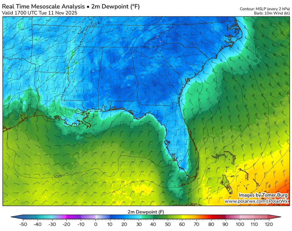
I love how the wake-free zone of stratocu nicely corresponds to the area of >50F dewpoints advected off the Florida Peninsula & adjacent Gulf coast area.
Taking a while for the sfc fluxes to moisten boundary layer enough to reach convective temp.
Plot via @burgwx.bsky.social's RTMA analysis. #FLwx
Taking a while for the sfc fluxes to moisten boundary layer enough to reach convective temp.
Plot via @burgwx.bsky.social's RTMA analysis. #FLwx
November 11, 2025 at 10:58 PM
I love how the wake-free zone of stratocu nicely corresponds to the area of >50F dewpoints advected off the Florida Peninsula & adjacent Gulf coast area.
Taking a while for the sfc fluxes to moisten boundary layer enough to reach convective temp.
Plot via @burgwx.bsky.social's RTMA analysis. #FLwx
Taking a while for the sfc fluxes to moisten boundary layer enough to reach convective temp.
Plot via @burgwx.bsky.social's RTMA analysis. #FLwx
Another way to put it -- in time it took to get 2️⃣ daily record lows at #KMIA, we set new record highs for more than a quarter of days in the calendar year b/w Nov 2014 to Nov 2025 (97/365 ~ 27% of all days).
So yes, a remarkable cold snap, but got to put in proper context of record tends. #FLwx
So yes, a remarkable cold snap, but got to put in proper context of record tends. #FLwx
November 11, 2025 at 9:44 PM
This cold outbreak was also impressive in how far south it pushed, even to #Miami, FL. The Miami International Airport #KMIA set its first record low (49°F) in more than a decade!
Between the last two record lows (11/2/14 to 11/11/25), there have been *97 new record highs* set at the airport. #FLwx
Between the last two record lows (11/2/14 to 11/11/25), there have been *97 new record highs* set at the airport. #FLwx
November 11, 2025 at 9:24 PM
Reposted by Philippe Papin

In the century leading up to 1975, nearly 6000 freighters went down in the Great Lakes.
The Edmund Fitzgerald was the last.
The last. In 50 years, not a single commercial freighter has been lost in the Great Lakes.
Why?
It's NOAA. Of course it's NOAA.
The Edmund Fitzgerald was the last.
The last. In 50 years, not a single commercial freighter has been lost in the Great Lakes.
Why?
It's NOAA. Of course it's NOAA.
November 11, 2025 at 1:50 AM
In the century leading up to 1975, nearly 6000 freighters went down in the Great Lakes.
The Edmund Fitzgerald was the last.
The last. In 50 years, not a single commercial freighter has been lost in the Great Lakes.
Why?
It's NOAA. Of course it's NOAA.
The Edmund Fitzgerald was the last.
The last. In 50 years, not a single commercial freighter has been lost in the Great Lakes.
Why?
It's NOAA. Of course it's NOAA.