


Philippe Papin
@pppapin.bsky.social
Sr. Hurricane Specialist at NHC 🌀 | Ph.D + M.S. via UAlbany & B.S. via UNCA | Enjoy all kinds of weather 🌤❄️⛈🌪| Thoughts are my own
Interesting to see that the only period where the shear went above normal in Aug-Sep-Oct was at end of October, when #Melissa was in the Caribbean.
There was significant shear affecting it from 10-21 to 10-24, but if there was no vortex removal, some of the increase may be the TC vortex itself?
There was significant shear affecting it from 10-21 to 10-24, but if there was no vortex removal, some of the increase may be the TC vortex itself?

November 30, 2025 at 8:15 PM
Interesting to see that the only period where the shear went above normal in Aug-Sep-Oct was at end of October, when #Melissa was in the Caribbean.
There was significant shear affecting it from 10-21 to 10-24, but if there was no vortex removal, some of the increase may be the TC vortex itself?
There was significant shear affecting it from 10-21 to 10-24, but if there was no vortex removal, some of the increase may be the TC vortex itself?
The last sentence resonated with me most. We now have a TC ensemble, in addition to hurricane regional models, capable of forecasting high-end TC intensity.
In Melissa's case, combo of HAFS-A/B & Google DeepMind increased confidence in a Category 5 forecast.
Human interpretation & NWP still vital.
In Melissa's case, combo of HAFS-A/B & Google DeepMind increased confidence in a Category 5 forecast.
Human interpretation & NWP still vital.

November 30, 2025 at 7:02 PM
The last sentence resonated with me most. We now have a TC ensemble, in addition to hurricane regional models, capable of forecasting high-end TC intensity.
In Melissa's case, combo of HAFS-A/B & Google DeepMind increased confidence in a Category 5 forecast.
Human interpretation & NWP still vital.
In Melissa's case, combo of HAFS-A/B & Google DeepMind increased confidence in a Category 5 forecast.
Human interpretation & NWP still vital.
Impressed with the resilience of #Senyar… looks like a coherent circulation may have made it across #Malaysia. Nice radar coverage showing the last 24h revolution as it crossed from the Malacca Strait ➡️ South China Sea.
Imagery courtesy of @zoom.earth
Imagery courtesy of @zoom.earth
November 28, 2025 at 6:02 PM
Impressed with the resilience of #Senyar… looks like a coherent circulation may have made it across #Malaysia. Nice radar coverage showing the last 24h revolution as it crossed from the Malacca Strait ➡️ South China Sea.
Imagery courtesy of @zoom.earth
Imagery courtesy of @zoom.earth
The National Hurricane Center has put together a 2025 Verification Preview.
Covers a prelim view on seasonal track, intensity, & genesis 🌀forecasts. Also touching on rapid intensification forecasts & Melissa which was the most impactful storm of the year.
URL: www.nhc.noaa.gov/pdf/NHC_Veri...
Covers a prelim view on seasonal track, intensity, & genesis 🌀forecasts. Also touching on rapid intensification forecasts & Melissa which was the most impactful storm of the year.
URL: www.nhc.noaa.gov/pdf/NHC_Veri...


November 25, 2025 at 3:28 AM
The National Hurricane Center has put together a 2025 Verification Preview.
Covers a prelim view on seasonal track, intensity, & genesis 🌀forecasts. Also touching on rapid intensification forecasts & Melissa which was the most impactful storm of the year.
URL: www.nhc.noaa.gov/pdf/NHC_Veri...
Covers a prelim view on seasonal track, intensity, & genesis 🌀forecasts. Also touching on rapid intensification forecasts & Melissa which was the most impactful storm of the year.
URL: www.nhc.noaa.gov/pdf/NHC_Veri...
We just so happened to be driving along the San Luis Reservoir on Hwy 152 where this was observed today. A good 10F difference between being in the fog (49F) vs in the clear (60F)! #CAwx

November 23, 2025 at 7:28 PM
We just so happened to be driving along the San Luis Reservoir on Hwy 152 where this was observed today. A good 10F difference between being in the fog (49F) vs in the clear (60F)! #CAwx
Love observing the local effects of terrain on the boundary layer fog in California. For instance, Check out the drainage into the San Luis Reservoir where low level flow is forced to curve anticyclonic into the local saddle point of the Coastal Range.
Makes for some photogenic views!
Makes for some photogenic views!
November 23, 2025 at 7:24 PM
Love observing the local effects of terrain on the boundary layer fog in California. For instance, Check out the drainage into the San Luis Reservoir where low level flow is forced to curve anticyclonic into the local saddle point of the Coastal Range.
Makes for some photogenic views!
Makes for some photogenic views!
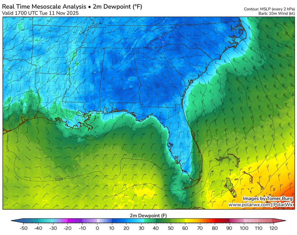
I love how the wake-free zone of stratocu nicely corresponds to the area of >50F dewpoints advected off the Florida Peninsula & adjacent Gulf coast area.
Taking a while for the sfc fluxes to moisten boundary layer enough to reach convective temp.
Plot via @burgwx.bsky.social's RTMA analysis. #FLwx
Taking a while for the sfc fluxes to moisten boundary layer enough to reach convective temp.
Plot via @burgwx.bsky.social's RTMA analysis. #FLwx
November 11, 2025 at 10:58 PM
I love how the wake-free zone of stratocu nicely corresponds to the area of >50F dewpoints advected off the Florida Peninsula & adjacent Gulf coast area.
Taking a while for the sfc fluxes to moisten boundary layer enough to reach convective temp.
Plot via @burgwx.bsky.social's RTMA analysis. #FLwx
Taking a while for the sfc fluxes to moisten boundary layer enough to reach convective temp.
Plot via @burgwx.bsky.social's RTMA analysis. #FLwx
So it only tied a record low that day -- which was also set on 2/20/1972. I see that in the threads data too.
I was specifically talking about setting a new record low at #KMIA, though it looks dependent if you take the record back to 1895 or just back to 1937. Ahh the devil is in the details.
I was specifically talking about setting a new record low at #KMIA, though it looks dependent if you take the record back to 1895 or just back to 1937. Ahh the devil is in the details.

November 11, 2025 at 10:17 PM
So it only tied a record low that day -- which was also set on 2/20/1972. I see that in the threads data too.
I was specifically talking about setting a new record low at #KMIA, though it looks dependent if you take the record back to 1895 or just back to 1937. Ahh the devil is in the details.
I was specifically talking about setting a new record low at #KMIA, though it looks dependent if you take the record back to 1895 or just back to 1937. Ahh the devil is in the details.
A few addendum:
1) Since posting, the CLIMIA came out indicating the low was actually 48°F!
2) Some of those record highs likely occurred on the same calendar day, but in different years b/w 2014-2025.
3) I'm using climo data 3/1/37 to now, which is the same period in xmacis.rcc-acis.org
1) Since posting, the CLIMIA came out indicating the low was actually 48°F!
2) Some of those record highs likely occurred on the same calendar day, but in different years b/w 2014-2025.
3) I'm using climo data 3/1/37 to now, which is the same period in xmacis.rcc-acis.org


November 11, 2025 at 10:10 PM
A few addendum:
1) Since posting, the CLIMIA came out indicating the low was actually 48°F!
2) Some of those record highs likely occurred on the same calendar day, but in different years b/w 2014-2025.
3) I'm using climo data 3/1/37 to now, which is the same period in xmacis.rcc-acis.org
1) Since posting, the CLIMIA came out indicating the low was actually 48°F!
2) Some of those record highs likely occurred on the same calendar day, but in different years b/w 2014-2025.
3) I'm using climo data 3/1/37 to now, which is the same period in xmacis.rcc-acis.org
Haha of course I sent this post just before the climo report showed it actually got down to 48F.
Should have clarified I only was using the #KMIA climo data from the Iowa State Mesonet page, which only goes back to 3/1/1937 -- not sure where Miami station data was located before that date.
Should have clarified I only was using the #KMIA climo data from the Iowa State Mesonet page, which only goes back to 3/1/1937 -- not sure where Miami station data was located before that date.

November 11, 2025 at 10:00 PM
Haha of course I sent this post just before the climo report showed it actually got down to 48F.
Should have clarified I only was using the #KMIA climo data from the Iowa State Mesonet page, which only goes back to 3/1/1937 -- not sure where Miami station data was located before that date.
Should have clarified I only was using the #KMIA climo data from the Iowa State Mesonet page, which only goes back to 3/1/1937 -- not sure where Miami station data was located before that date.
This cold outbreak was also impressive in how far south it pushed, even to #Miami, FL. The Miami International Airport #KMIA set its first record low (49°F) in more than a decade!
Between the last two record lows (11/2/14 to 11/11/25), there have been *97 new record highs* set at the airport. #FLwx
Between the last two record lows (11/2/14 to 11/11/25), there have been *97 new record highs* set at the airport. #FLwx
November 11, 2025 at 9:24 PM
Here is a zoomed in view of the radar along the S shore of Lake Michigan tonight.
Likely some multi inch per hour snowfall rates and potential whiteout conditions as this band moves over Chicago metro & adjacent areas.
Good thing this is occurring overnight & not during a major travel period.
Likely some multi inch per hour snowfall rates and potential whiteout conditions as this band moves over Chicago metro & adjacent areas.
Good thing this is occurring overnight & not during a major travel period.
November 10, 2025 at 6:11 AM
Here is a zoomed in view of the radar along the S shore of Lake Michigan tonight.
Likely some multi inch per hour snowfall rates and potential whiteout conditions as this band moves over Chicago metro & adjacent areas.
Good thing this is occurring overnight & not during a major travel period.
Likely some multi inch per hour snowfall rates and potential whiteout conditions as this band moves over Chicago metro & adjacent areas.
Good thing this is occurring overnight & not during a major travel period.
Fascinating interaction of #wx scales near Lake Michigan tonight.
A Lake Effect Snow #LES band streched N-to-S across the lake, but a potent vortmax dropped in just west, providing large-scale ascent & changing morphology of band into a mesolow, enhancing #snow over #Chicago & Indiana tonight. 🌨️
A Lake Effect Snow #LES band streched N-to-S across the lake, but a potent vortmax dropped in just west, providing large-scale ascent & changing morphology of band into a mesolow, enhancing #snow over #Chicago & Indiana tonight. 🌨️
November 10, 2025 at 6:05 AM
I am not the first person to mention this, but the fast #ERC evolution feels similar to the work in Fischer et al. (2020) documented in rapid intensification and ERC's of #Hurricane #Irma.
In particular the 2nd ERC event where intensification continued.
URL: journals.ametsoc.org/view/journal...
In particular the 2nd ERC event where intensification continued.
URL: journals.ametsoc.org/view/journal...

November 3, 2025 at 6:24 PM
I am not the first person to mention this, but the fast #ERC evolution feels similar to the work in Fischer et al. (2020) documented in rapid intensification and ERC's of #Hurricane #Irma.
In particular the 2nd ERC event where intensification continued.
URL: journals.ametsoc.org/view/journal...
In particular the 2nd ERC event where intensification continued.
URL: journals.ametsoc.org/view/journal...
Here is a zoomed in radar version of 28 Oct showing #Melissa 's inner core evolution before #Jamaica landfall.
Radar evidence some type of fast eyewall replacement cycle, #ERC, occurred. Eye went from 10 n mi to 15 n mi on VDM fixes & more intensification occured after ERC.
Horrible for Jamaica 😞
Radar evidence some type of fast eyewall replacement cycle, #ERC, occurred. Eye went from 10 n mi to 15 n mi on VDM fixes & more intensification occured after ERC.
Horrible for Jamaica 😞
November 3, 2025 at 6:10 PM
I was not referring to the d(prog)/dt plots which are excellent, but the regular guidance plots where it says "NHC forecast" -- it may be better to re-label at "prior interpolated NHC forecast"
You could also show both OFCI & OFCL when it becomes available like @tropicaltidbits.bsky.social does.
You could also show both OFCI & OFCL when it becomes available like @tropicaltidbits.bsky.social does.


October 30, 2025 at 4:27 PM
I was not referring to the d(prog)/dt plots which are excellent, but the regular guidance plots where it says "NHC forecast" -- it may be better to re-label at "prior interpolated NHC forecast"
You could also show both OFCI & OFCL when it becomes available like @tropicaltidbits.bsky.social does.
You could also show both OFCI & OFCL when it becomes available like @tropicaltidbits.bsky.social does.
Annotating a long 3+ day loop of #Hurricane #Melissa from Kingston, #Jamaica radar.
2️⃣ periods appear where an eyewall replacement cycle, #ERC, looked underway. In both cases, inner eyewall stayed intact & outer bands merged, resulting in a larger eye & strengthening after.
A remarkable evolution 🌀
2️⃣ periods appear where an eyewall replacement cycle, #ERC, looked underway. In both cases, inner eyewall stayed intact & outer bands merged, resulting in a larger eye & strengthening after.
A remarkable evolution 🌀
October 30, 2025 at 6:54 AM
Annotating a long 3+ day loop of #Hurricane #Melissa from Kingston, #Jamaica radar.
2️⃣ periods appear where an eyewall replacement cycle, #ERC, looked underway. In both cases, inner eyewall stayed intact & outer bands merged, resulting in a larger eye & strengthening after.
A remarkable evolution 🌀
2️⃣ periods appear where an eyewall replacement cycle, #ERC, looked underway. In both cases, inner eyewall stayed intact & outer bands merged, resulting in a larger eye & strengthening after.
A remarkable evolution 🌀
Just to bring this point home, sharing a couple of figs from Klotzbach & Oliver (2015) showing how MJO phase influences TC activity in the NATL basin.
Favorable phases are 1-3, unfavorable are 5-7.
Well -- #Melissa reached peak intensity in MJO Phase 5 & this was a high MJO amplitude as well. 🤷♂️
Favorable phases are 1-3, unfavorable are 5-7.
Well -- #Melissa reached peak intensity in MJO Phase 5 & this was a high MJO amplitude as well. 🤷♂️


October 30, 2025 at 2:15 AM
Just to bring this point home, sharing a couple of figs from Klotzbach & Oliver (2015) showing how MJO phase influences TC activity in the NATL basin.
Favorable phases are 1-3, unfavorable are 5-7.
Well -- #Melissa reached peak intensity in MJO Phase 5 & this was a high MJO amplitude as well. 🤷♂️
Favorable phases are 1-3, unfavorable are 5-7.
Well -- #Melissa reached peak intensity in MJO Phase 5 & this was a high MJO amplitude as well. 🤷♂️
Re-upping this thread, but like a month ago, #Melissa peaked in what is thought as a less favorable intereseasonal base state: Convective MJO envelope in maritime continent w/ suppression over NATL.
Recurring theme - NATL 2025 TC activity occurring out of phase with typical favorable MJO phases. 🤷♂️
Recurring theme - NATL 2025 TC activity occurring out of phase with typical favorable MJO phases. 🤷♂️

October 30, 2025 at 1:49 AM
Re-upping this thread, but like a month ago, #Melissa peaked in what is thought as a less favorable intereseasonal base state: Convective MJO envelope in maritime continent w/ suppression over NATL.
Recurring theme - NATL 2025 TC activity occurring out of phase with typical favorable MJO phases. 🤷♂️
Recurring theme - NATL 2025 TC activity occurring out of phase with typical favorable MJO phases. 🤷♂️
#Melissa's landfall intensity of 185 mph/892 mb ties it with the Florida Key's Labor Day Hurricane of 1935 as the record minimum pressure of any TC making landfall *anywhere* the NATL basin. I feel for the residents of #Jamaica 😞
Zoomed in G19 visible meso loop courtesy of @cyclonicwx.bsky.social
Zoomed in G19 visible meso loop courtesy of @cyclonicwx.bsky.social
October 28, 2025 at 5:14 PM
#Melissa's landfall intensity of 185 mph/892 mb ties it with the Florida Key's Labor Day Hurricane of 1935 as the record minimum pressure of any TC making landfall *anywhere* the NATL basin. I feel for the residents of #Jamaica 😞
Zoomed in G19 visible meso loop courtesy of @cyclonicwx.bsky.social
Zoomed in G19 visible meso loop courtesy of @cyclonicwx.bsky.social
#Melissa unfortunately is still intensifying. A 9am EDT Tropical Cyclone Update indicates that winds are up to 180 mph, with an estimated minimum pressure of 896 mb.
You can see how GLM lightning has 📈 in the past hour, encircling the eye, with eye WV temp still increasing!
You can see how GLM lightning has 📈 in the past hour, encircling the eye, with eye WV temp still increasing!
October 28, 2025 at 1:13 PM
#Melissa unfortunately is still intensifying. A 9am EDT Tropical Cyclone Update indicates that winds are up to 180 mph, with an estimated minimum pressure of 896 mb.
You can see how GLM lightning has 📈 in the past hour, encircling the eye, with eye WV temp still increasing!
You can see how GLM lightning has 📈 in the past hour, encircling the eye, with eye WV temp still increasing!
Here is a 54h WV loop of #Melissa as it underwent rapid intensification from a 60 kt TS ➡️ 150 kt cat 5 #Hurricane.
Pay attention to how "warm" eye becomes at the end of the loop which ends at 18 UTC 27 Oct.
Color scale ends at -5C & eye temp on the last few frames was warmer than that 🤯
Pay attention to how "warm" eye becomes at the end of the loop which ends at 18 UTC 27 Oct.
Color scale ends at -5C & eye temp on the last few frames was warmer than that 🤯
October 27, 2025 at 11:42 PM
Here is a 54h WV loop of #Melissa as it underwent rapid intensification from a 60 kt TS ➡️ 150 kt cat 5 #Hurricane.
Pay attention to how "warm" eye becomes at the end of the loop which ends at 18 UTC 27 Oct.
Color scale ends at -5C & eye temp on the last few frames was warmer than that 🤯
Pay attention to how "warm" eye becomes at the end of the loop which ends at 18 UTC 27 Oct.
Color scale ends at -5C & eye temp on the last few frames was warmer than that 🤯
An addendum here -- after further review, it looks like the Jamaica landfall intensity of #Gilbert was actually 115 kt - Cat 4.
Data to verify this is from the HURDAT2 database -- www.nhc.noaa.gov/data/#hurdat
Data to verify this is from the HURDAT2 database -- www.nhc.noaa.gov/data/#hurdat

October 27, 2025 at 7:41 PM
An addendum here -- after further review, it looks like the Jamaica landfall intensity of #Gilbert was actually 115 kt - Cat 4.
Data to verify this is from the HURDAT2 database -- www.nhc.noaa.gov/data/#hurdat
Data to verify this is from the HURDAT2 database -- www.nhc.noaa.gov/data/#hurdat
Just a follow up to say this did end up verifying:
AT 5pm Oct 25th, #Melissa was at 16.6N 75.5W.
By 11pm Oct 26th, #Melissa was at 16.3N 77.7W.
Just enough S of due W motion to delay serious rainfall hazards in #Jamaica temporary, though onset of catastrophic rainfall impacts likely today.
AT 5pm Oct 25th, #Melissa was at 16.6N 75.5W.
By 11pm Oct 26th, #Melissa was at 16.3N 77.7W.
Just enough S of due W motion to delay serious rainfall hazards in #Jamaica temporary, though onset of catastrophic rainfall impacts likely today.


October 27, 2025 at 5:20 PM
The caveat being that this is the "working" best track & the operational values can (& do) change before the final best-track report comes out.
But yes, interesting to see the intensification rate plateau a bit yesterday. Reminded me of #Dorian (2019) w/ working best track at 120-130 kt for 24h.
But yes, interesting to see the intensification rate plateau a bit yesterday. Reminded me of #Dorian (2019) w/ working best track at 120-130 kt for 24h.

October 27, 2025 at 3:04 PM
The caveat being that this is the "working" best track & the operational values can (& do) change before the final best-track report comes out.
But yes, interesting to see the intensification rate plateau a bit yesterday. Reminded me of #Dorian (2019) w/ working best track at 120-130 kt for 24h.
But yes, interesting to see the intensification rate plateau a bit yesterday. Reminded me of #Dorian (2019) w/ working best track at 120-130 kt for 24h.