


Brian Etherton
@briane678.bsky.social
Hello folks! I like the weather, and coding, and helping to connect people & ideas. I LOVE my family. (sunset image above: Seaford in Sussex, taken looking towards the entrance to Newhaven. Photo from Chris Plumley https://bsky.app/profile/crp.bsky.soci)
Good insights from a great meteorologist and Disney fan!

Southern CA just experienced one of its wettest mid-November periods on record, and Phoenix is having a welcome wet start to the cool season. Also talking about some flash flood and severe weather risk next couple of days. open.substack.com/pub/balanced...

Looking at a record wet mid-November for parts of the Southwest, while record warmth persists in the Southeast
Some flash flood and severe weather risk early next week in the south central US, plus a look at Thanksgiving travel weather
open.substack.com
November 22, 2025 at 5:39 PM
Good insights from a great meteorologist and Disney fan!
An air pressure of 947.9 hPa was recorded at Baltasound, Shetland, provisionally setting a new UK lowest pressure record for October.
Storm Amy has been record breaking ⚠️
An air pressure of 947.9 hPa was recorded at Baltasound, Shetland, provisionally setting a new UK lowest pressure record for October.
Northern Ireland provisionally recorded its strongest October wind gust on record, with a gust of 92 mph at Magilligan.
An air pressure of 947.9 hPa was recorded at Baltasound, Shetland, provisionally setting a new UK lowest pressure record for October.
Northern Ireland provisionally recorded its strongest October wind gust on record, with a gust of 92 mph at Magilligan.
October 4, 2025 at 8:41 PM
An air pressure of 947.9 hPa was recorded at Baltasound, Shetland, provisionally setting a new UK lowest pressure record for October.
An interesting weather event in the western United States. Not at all unheard of, but interesting!

Moisture from the remnants of Tropical Storm Mario move over California, leading to thunderstorms and heavy rainfall across the state.
September 18, 2025 at 6:43 PM
An interesting weather event in the western United States. Not at all unheard of, but interesting!
Reposted by Brian Etherton

Wow. Just off the charts intensification from Hurricane Erin

August 16, 2025 at 7:04 PM
Wow. Just off the charts intensification from Hurricane Erin
Reposted by Brian Etherton

What is it about this century? What could it be? ♨️🌎
From @agnes1972.bsky.social on his X account: "With Erin, the last ten years have now seen 11 category five Atlantic hurricanes. This puts us even further ahead of 2007, which held the previous record of nine. Remarkable."
From @agnes1972.bsky.social on his X account: "With Erin, the last ten years have now seen 11 category five Atlantic hurricanes. This puts us even further ahead of 2007, which held the previous record of nine. Remarkable."

August 16, 2025 at 6:38 PM
What is it about this century? What could it be? ♨️🌎
From @agnes1972.bsky.social on his X account: "With Erin, the last ten years have now seen 11 category five Atlantic hurricanes. This puts us even further ahead of 2007, which held the previous record of nine. Remarkable."
From @agnes1972.bsky.social on his X account: "With Erin, the last ten years have now seen 11 category five Atlantic hurricanes. This puts us even further ahead of 2007, which held the previous record of nine. Remarkable."
Reposted by Brian Etherton
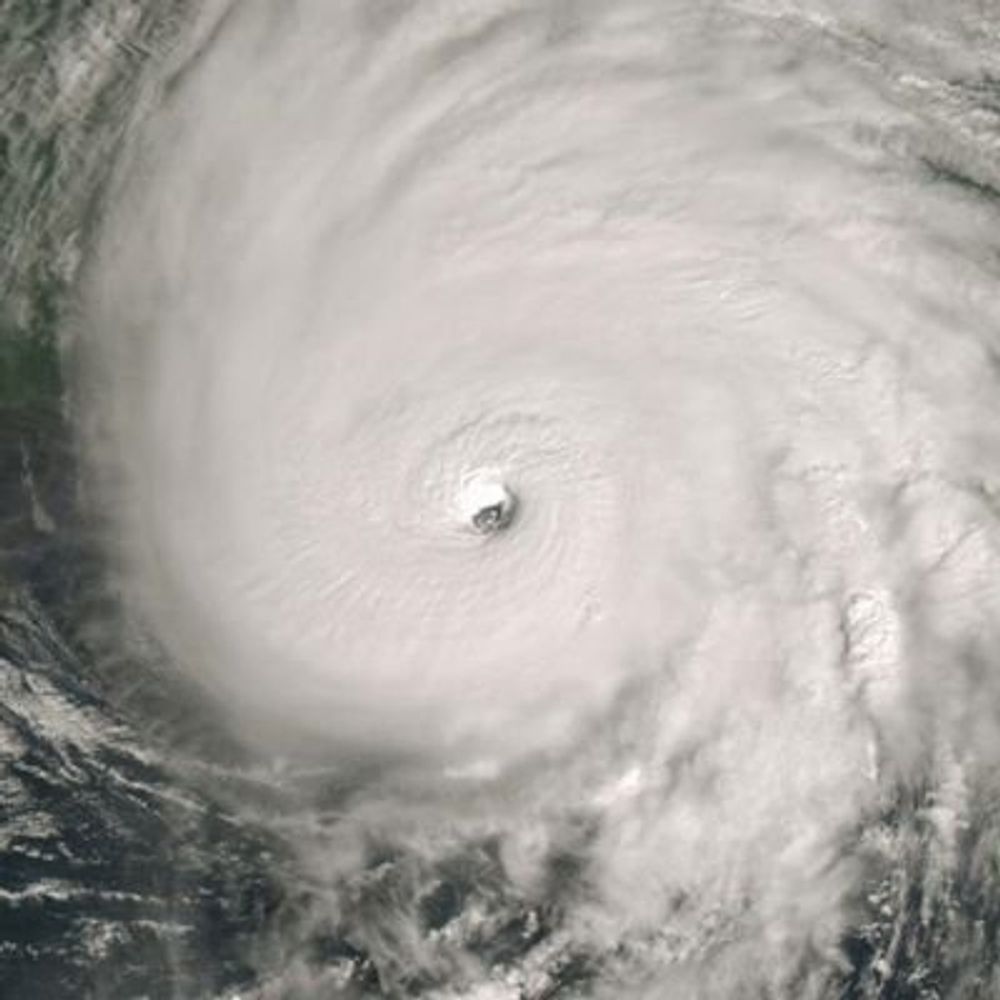
Just 24 hours ago, #Erin was just a 65kt Category 1 hurricane. Now, after explosive intensification, it's increased 75kt to 140kt! Cool to see the structure improve, then completely bomb out
August 16, 2025 at 3:34 PM
Just 24 hours ago, #Erin was just a 65kt Category 1 hurricane. Now, after explosive intensification, it's increased 75kt to 140kt! Cool to see the structure improve, then completely bomb out
Reposted by Brian Etherton

#Hurricane #Erin has just become a Category 5 hurricane (140 kt / 917 mb).
Earliest known occurrence of Cat 5 in open Atlantic (outside Caribbean & Gulf).
Rapid Intensification (+75 kt in 24h!)
To illustrate how remarkable this period of #RI has been check out this WV 18 hour animation below ⤵️
Earliest known occurrence of Cat 5 in open Atlantic (outside Caribbean & Gulf).
Rapid Intensification (+75 kt in 24h!)
To illustrate how remarkable this period of #RI has been check out this WV 18 hour animation below ⤵️
August 16, 2025 at 3:51 PM
#Hurricane #Erin has just become a Category 5 hurricane (140 kt / 917 mb).
Earliest known occurrence of Cat 5 in open Atlantic (outside Caribbean & Gulf).
Rapid Intensification (+75 kt in 24h!)
To illustrate how remarkable this period of #RI has been check out this WV 18 hour animation below ⤵️
Earliest known occurrence of Cat 5 in open Atlantic (outside Caribbean & Gulf).
Rapid Intensification (+75 kt in 24h!)
To illustrate how remarkable this period of #RI has been check out this WV 18 hour animation below ⤵️
Reposted by Brian Etherton

A July hurricane-force non-tropical low near Greenland on July 11, 2025.
Central pressure fell into the low to mid 960s. At least 5 July — including all warm season months — records were set by the storm.
From Thule/Pituffik Space Force Base in Greenland, who broke their July record by 15 hPa.
Central pressure fell into the low to mid 960s. At least 5 July — including all warm season months — records were set by the storm.
From Thule/Pituffik Space Force Base in Greenland, who broke their July record by 15 hPa.

July 12, 2025 at 2:40 AM
A July hurricane-force non-tropical low near Greenland on July 11, 2025.
Central pressure fell into the low to mid 960s. At least 5 July — including all warm season months — records were set by the storm.
From Thule/Pituffik Space Force Base in Greenland, who broke their July record by 15 hPa.
Central pressure fell into the low to mid 960s. At least 5 July — including all warm season months — records were set by the storm.
From Thule/Pituffik Space Force Base in Greenland, who broke their July record by 15 hPa.
Reposted by Brian Etherton

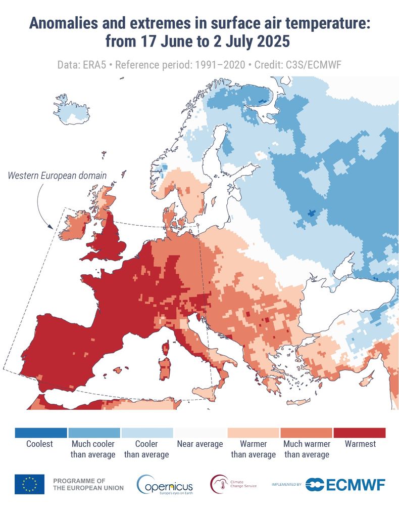
The June heat across Europe was the worst on record due to an intense persistent heat dome - a blocked upper level pattern - which are becoming more common this time of year due to global warming. Europe is a ground zero for these. Heat index numbers reached 48C (118F). 1/
July 10, 2025 at 3:15 PM
The June heat across Europe was the worst on record due to an intense persistent heat dome - a blocked upper level pattern - which are becoming more common this time of year due to global warming. Europe is a ground zero for these. Heat index numbers reached 48C (118F). 1/
Reposted by Brian Etherton


Alan Gerard has started a substack that I find very useful. Here is the latest: high temperatures 15 degrees above normal in the US midwest and Canada. Details below!
An amazing tail event is occurring in the upper Midwest and southern Canada with record temps being broken by 15 deg. If this were happening in summer it would be a big problem and we need to be aware that these events are increasing in likelihood. Read more here. open.substack.com/pub/balanced...

Insane warmth in the upper Midwest and south central Canada
And a more active severe weather pattern on the horizon
open.substack.com
May 13, 2025 at 4:25 PM
Alan Gerard has started a substack that I find very useful. Here is the latest: high temperatures 15 degrees above normal in the US midwest and Canada. Details below!
This is hot for Texas - I expect ERCOT will be challenged by these conditions.


May 13, 2025 at 3:53 PM
This is hot for Texas - I expect ERCOT will be challenged by these conditions.

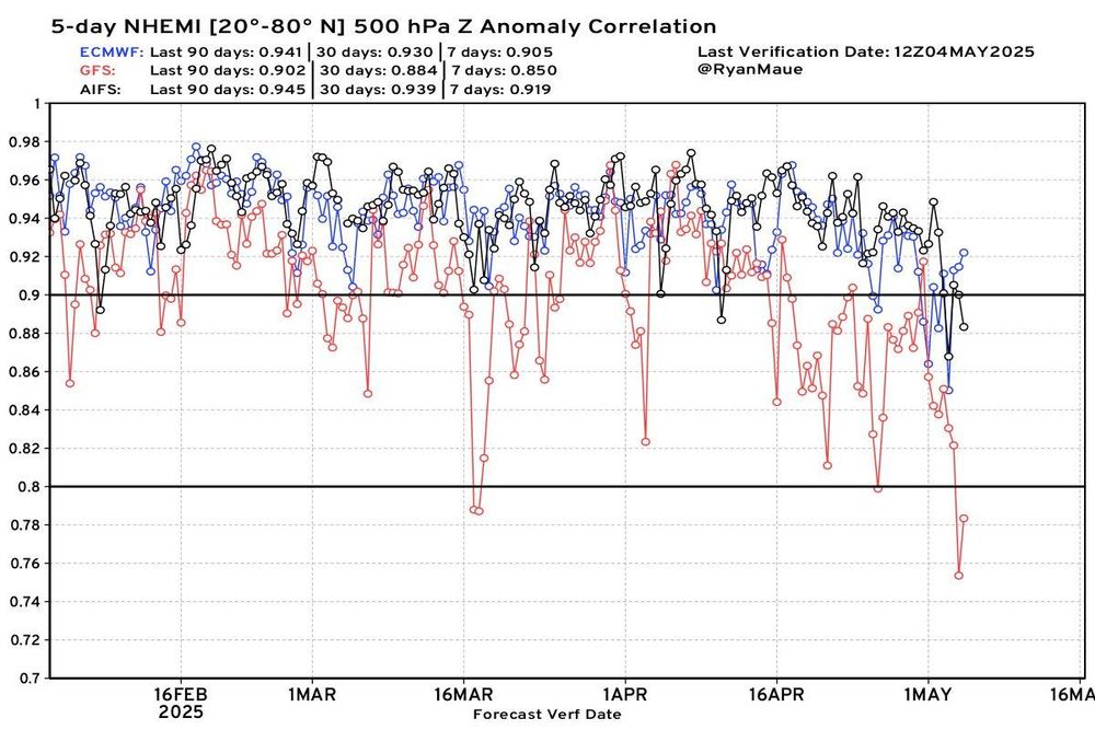
Over the last 7 days, last 30 days, last 90 days, of these 3 models: the AI model from ECMWF known as AIFS, the traditional weather models ECMWF IFS and the NOAA GFS, it was the AI weather model AIFS that has the best 5-day Northern Hemisphere (20N to 80N) anomaly correlation. (image: Ryan Maue)
May 5, 2025 at 5:01 PM
Over the last 7 days, last 30 days, last 90 days, of these 3 models: the AI model from ECMWF known as AIFS, the traditional weather models ECMWF IFS and the NOAA GFS, it was the AI weather model AIFS that has the best 5-day Northern Hemisphere (20N to 80N) anomaly correlation. (image: Ryan Maue)
Reposted by Brian Etherton

Radar and SPC damaging wind report loop of the severe storm complex/derecho that expanded from Illinois into Pennsylvania on Tuesday, producing widespread wind damage especially across Ohio and Pennsylvania:
May 2, 2025 at 12:45 AM
Radar and SPC damaging wind report loop of the severe storm complex/derecho that expanded from Illinois into Pennsylvania on Tuesday, producing widespread wind damage especially across Ohio and Pennsylvania:
California, which recently passed Japan to be the world's 4th largest economy, appears to be achieving such economic success while also achieving success in the ever increased use of renewable energy.

2025 record of 9.75 hours of >100% Wind-Water-Solar on the California ISO grid on Wed April 23.
Also the 40th-straight and 81st of 113 (72%) days with >100% WWS.
Peak WWS was 156.5% of demand and 24-avg was 77.6% of demand, alsoboth 2025 records
Gas is down 45% v '23 and 26% v '24
Also the 40th-straight and 81st of 113 (72%) days with >100% WWS.
Peak WWS was 156.5% of demand and 24-avg was 77.6% of demand, alsoboth 2025 records
Gas is down 45% v '23 and 26% v '24

April 24, 2025 at 9:25 PM
California, which recently passed Japan to be the world's 4th largest economy, appears to be achieving such economic success while also achieving success in the ever increased use of renewable energy.
Reposted by Brian Etherton

It's warming up across the UK this week, with the highest temperatures likely peaking on Friday 😎
April 1, 2025 at 10:53 AM
It's warming up across the UK this week, with the highest temperatures likely peaking on Friday 😎
Reposted by Brian Etherton

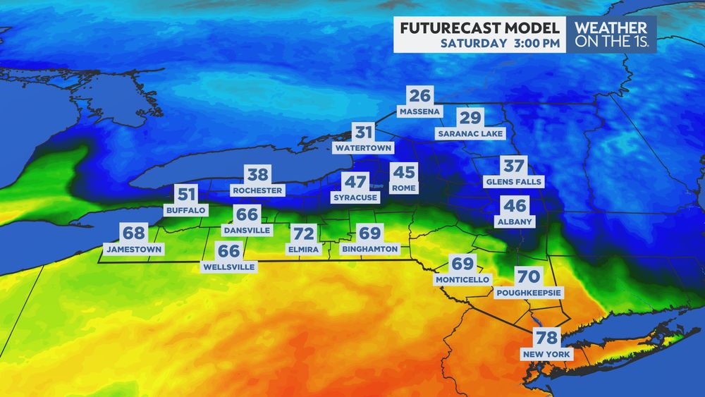
Man, what a temperature gradient across New York tomorrow! Our in-house model showing nearly 80° in NYC to the 20s in the North Country. #NYwx #wxonthe1s
March 28, 2025 at 4:08 PM
Man, what a temperature gradient across New York tomorrow! Our in-house model showing nearly 80° in NYC to the 20s in the North Country. #NYwx #wxonthe1s
Reposted by Brian Etherton

That is one pretty low off the Pacific Northwest coast.
March 27, 2025 at 2:10 AM
That is one pretty low off the Pacific Northwest coast.
This is really really unusual!
An unusual setup could lead to significant hail along the I-5 corridor between Seattle, Portland, and Eugene on Wednesday.
Forecasters warn the strongest storms could produce hailstones the size of a hen egg (2.00" in diameter) or larger.
www.damweather.com/2025/03/supe...
Forecasters warn the strongest storms could produce hailstones the size of a hen egg (2.00" in diameter) or larger.
www.damweather.com/2025/03/supe...
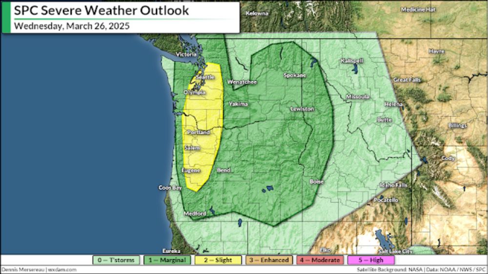
Supercells with large hail possible around Seattle, Portland on Wednesday
Significant hail is possible along the I-5 corridor from Seattle to Eugene on Wednesday.
www.damweather.com
March 25, 2025 at 7:00 PM
This is really really unusual!
Reposted by Brian Etherton

NWS crews have confirmed more than 80 tornadoes from the March 14-16 outbreak. The outbreak produced at least four EF-4 tornadoes and at least nine EF-3 tornadoes.

March 18, 2025 at 8:20 PM
NWS crews have confirmed more than 80 tornadoes from the March 14-16 outbreak. The outbreak produced at least four EF-4 tornadoes and at least nine EF-3 tornadoes.
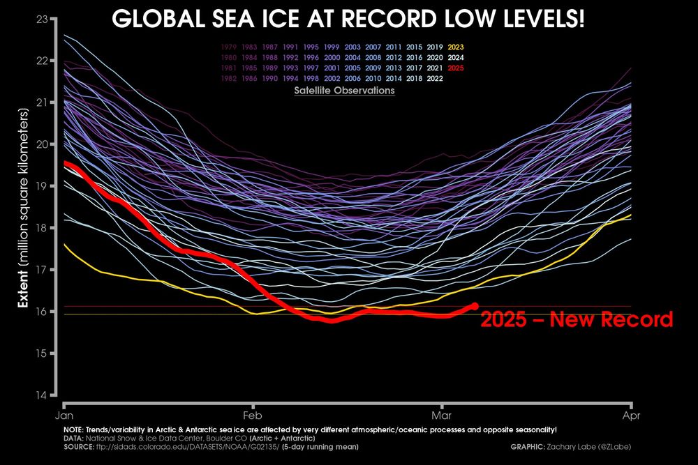
The extent of sea ice around the world continues to remain the smallest in our satellite observation history for this time of year.

The extent of sea ice around the world continues to remain the smallest in our satellite observation history for this time of year...
More graphs at zacklabe.com/global-sea-i.... Data from @nsidc.bsky.social.
More graphs at zacklabe.com/global-sea-i.... Data from @nsidc.bsky.social.
March 9, 2025 at 3:00 PM
The extent of sea ice around the world continues to remain the smallest in our satellite observation history for this time of year.
Agreed: a low pressure center THIS deep in THIS location is not at all common. That the forecast of it is relatively confident 6-days in advance is also uncommon.

Don't think I have ever seen anything like this in this portion of the country from an ensemble 6 days out before.

March 9, 2025 at 2:58 PM
Agreed: a low pressure center THIS deep in THIS location is not at all common. That the forecast of it is relatively confident 6-days in advance is also uncommon.