


Zack Labe
@zacklabe.com
Climate Scientist at @climatecentral.org | PhD | Passionate about improving science communication through data-driven stories | Harrisburg, PA | https://zacklabe.com/
Views, thoughts, and opinions expressed here are only my own.
Views, thoughts, and opinions expressed here are only my own.
Pinned
Zack Labe
@zacklabe.com
· Nov 30
🧵 Looking for (polar) climate data visualizations? Start here! 📈📉🧪⚒️🌊
+ Polar climate change: zacklabe.com/arctic-sea-i...
+ Global climate change indicators: zacklabe.com/climate-chan...
+ #Arctic sea ice extent: zacklabe.com/arctic-sea-i...
+ #Antarctic sea ice: zacklabe.com/antarctic-se...
+ Polar climate change: zacklabe.com/arctic-sea-i...
+ Global climate change indicators: zacklabe.com/climate-chan...
+ #Arctic sea ice extent: zacklabe.com/arctic-sea-i...
+ #Antarctic sea ice: zacklabe.com/antarctic-se...
Last month was the 4th warmest January on record for the average global sea surface temperature...
Graphic using NOAA ERSSTv5 data. Methods described in doi.org/10.1175/JCLI... 🌊
Graphic using NOAA ERSSTv5 data. Methods described in doi.org/10.1175/JCLI... 🌊

February 9, 2026 at 1:06 PM
Last month was the 4th warmest January on record for the average global sea surface temperature...
Graphic using NOAA ERSSTv5 data. Methods described in doi.org/10.1175/JCLI... 🌊
Graphic using NOAA ERSSTv5 data. Methods described in doi.org/10.1175/JCLI... 🌊
(Climate) "Coverage is punctuated by bursts of attention to late-year international climate conferences, but the recent decline persists even when you smooth that out. And it appears poised to continue. The real question is how far coverage can fall."
by open.substack.com/pub/reportea...
by open.substack.com/pub/reportea...

February 8, 2026 at 2:42 PM
(Climate) "Coverage is punctuated by bursts of attention to late-year international climate conferences, but the recent decline persists even when you smooth that out. And it appears poised to continue. The real question is how far coverage can fall."
by open.substack.com/pub/reportea...
by open.substack.com/pub/reportea...
Impossible to quantify how much this has already hurt the next generation of scientists.
This a word cloud from the titles of ~1100 terminated NSF grants.
It is hard not to see these grant terminations as an attack on the training of the future United States scientific workforce.
It is hard not to see these grant terminations as an attack on the training of the future United States scientific workforce.

February 7, 2026 at 9:34 PM
Impossible to quantify how much this has already hurt the next generation of scientists.
Carbon dioxide (CO₂) averaged about 429 ppm in January 2026
10 years ago January averaged about 403 ppm
Data available at gml.noaa.gov/ccgg/trends/
10 years ago January averaged about 403 ppm
Data available at gml.noaa.gov/ccgg/trends/

February 7, 2026 at 7:22 PM
Carbon dioxide (CO₂) averaged about 429 ppm in January 2026
10 years ago January averaged about 403 ppm
Data available at gml.noaa.gov/ccgg/trends/
10 years ago January averaged about 403 ppm
Data available at gml.noaa.gov/ccgg/trends/
Look how fast the Arctic Ocean is warming during the month of February over the last four decades...
Data from @copernicusecmwf.bsky.social ERA5 reanalysis.
Data from @copernicusecmwf.bsky.social ERA5 reanalysis.

February 7, 2026 at 3:14 PM
Look how fast the Arctic Ocean is warming during the month of February over the last four decades...
Data from @copernicusecmwf.bsky.social ERA5 reanalysis.
Data from @copernicusecmwf.bsky.social ERA5 reanalysis.
Friday ice update - #Arctic sea ice extent is currently the 4th lowest on record (JAXA data)...
• about 140,000 km² below the 2010s mean
• about 790,000 km² below the 2000s mean
• about 1,380,000 km² below the 1990s mean
• about 1,800,000 km² below the 1980s mean
More: zacklabe.com/arctic-sea-i...
• about 140,000 km² below the 2010s mean
• about 790,000 km² below the 2000s mean
• about 1,380,000 km² below the 1990s mean
• about 1,800,000 km² below the 1980s mean
More: zacklabe.com/arctic-sea-i...

February 6, 2026 at 2:04 PM
Friday ice update - #Arctic sea ice extent is currently the 4th lowest on record (JAXA data)...
• about 140,000 km² below the 2010s mean
• about 790,000 km² below the 2000s mean
• about 1,380,000 km² below the 1990s mean
• about 1,800,000 km² below the 1980s mean
More: zacklabe.com/arctic-sea-i...
• about 140,000 km² below the 2010s mean
• about 790,000 km² below the 2000s mean
• about 1,380,000 km² below the 1990s mean
• about 1,800,000 km² below the 1980s mean
More: zacklabe.com/arctic-sea-i...
100 years of changing February sea ice...
Total data set available from 1850 through 2017. Summary of methods: www.carbonbrief.org/guest-post-p.... More sea ice reconstructions at zacklabe.com/arctic-sea-i...
Total data set available from 1850 through 2017. Summary of methods: www.carbonbrief.org/guest-post-p.... More sea ice reconstructions at zacklabe.com/arctic-sea-i...
February 6, 2026 at 1:09 PM
100 years of changing February sea ice...
Total data set available from 1850 through 2017. Summary of methods: www.carbonbrief.org/guest-post-p.... More sea ice reconstructions at zacklabe.com/arctic-sea-i...
Total data set available from 1850 through 2017. Summary of methods: www.carbonbrief.org/guest-post-p.... More sea ice reconstructions at zacklabe.com/arctic-sea-i...
Patterns of February temperatures in the #Antarctic when averaged by decade...
Data from @copernicusecmwf.bsky.social ERA5 reanalysis.
Data from @copernicusecmwf.bsky.social ERA5 reanalysis.

February 6, 2026 at 12:47 AM
Patterns of February temperatures in the #Antarctic when averaged by decade...
Data from @copernicusecmwf.bsky.social ERA5 reanalysis.
Data from @copernicusecmwf.bsky.social ERA5 reanalysis.
"In a warming world there are… Still freezing nights — but fewer of them.
In a warming world there are… Still cold streaks — but shorter ones.
In a warming world there are… Still extremely cold days — but not as cold."
➡️ More in @climatecentral.org's latest: www.climatecentral.org/climate-matt...
In a warming world there are… Still cold streaks — but shorter ones.
In a warming world there are… Still extremely cold days — but not as cold."
➡️ More in @climatecentral.org's latest: www.climatecentral.org/climate-matt...

February 5, 2026 at 9:00 PM
"In a warming world there are… Still freezing nights — but fewer of them.
In a warming world there are… Still cold streaks — but shorter ones.
In a warming world there are… Still extremely cold days — but not as cold."
➡️ More in @climatecentral.org's latest: www.climatecentral.org/climate-matt...
In a warming world there are… Still cold streaks — but shorter ones.
In a warming world there are… Still extremely cold days — but not as cold."
➡️ More in @climatecentral.org's latest: www.climatecentral.org/climate-matt...
Reposted by Zack Labe


Last month observed unusually high sea surface temperatures in areas near a lack of sea ice, such as the Labrador Sea and western Bering Sea. Ocean temperatures continued to be very warm north of Scandinavia as well.
Data from NOAA OISSTv2.1 at www.ncei.noaa.gov/products/opt... 🌊
Data from NOAA OISSTv2.1 at www.ncei.noaa.gov/products/opt... 🌊

February 5, 2026 at 1:05 PM
Last month observed unusually high sea surface temperatures in areas near a lack of sea ice, such as the Labrador Sea and western Bering Sea. Ocean temperatures continued to be very warm north of Scandinavia as well.
Data from NOAA OISSTv2.1 at www.ncei.noaa.gov/products/opt... 🌊
Data from NOAA OISSTv2.1 at www.ncei.noaa.gov/products/opt... 🌊
"How and how much the media cover climate change matters greatly.
This 2025 downward trend appears in contrast with ongoing global warming where average temperatures in the most recent years have been the highest in nearly 150 years of recorded history."
This 2025 downward trend appears in contrast with ongoing global warming where average temperatures in the most recent years have been the highest in nearly 150 years of recorded history."
MeCCO Monthly Summaries :: Media and Climate Change Observatory
mecco.colorado.edu
February 5, 2026 at 2:35 AM
"How and how much the media cover climate change matters greatly.
This 2025 downward trend appears in contrast with ongoing global warming where average temperatures in the most recent years have been the highest in nearly 150 years of recorded history."
This 2025 downward trend appears in contrast with ongoing global warming where average temperatures in the most recent years have been the highest in nearly 150 years of recorded history."
Trends in February temperatures over land areas for the last 50 years...
Data from NOAAGlobalTemp v6.0.0 (www.ncei.noaa.gov/products/lan...)
Data from NOAAGlobalTemp v6.0.0 (www.ncei.noaa.gov/products/lan...)

February 4, 2026 at 9:03 PM
Trends in February temperatures over land areas for the last 50 years...
Data from NOAAGlobalTemp v6.0.0 (www.ncei.noaa.gov/products/lan...)
Data from NOAAGlobalTemp v6.0.0 (www.ncei.noaa.gov/products/lan...)
#Arctic air temperature rank by month over the satellite era - now updated through January 2026...
+ Ranks: 1=warmest (red), 47/48=coldest (blue)
+ Download higher resolution: zacklabe.com/arctic-tempe...
+ Ranks: 1=warmest (red), 47/48=coldest (blue)
+ Download higher resolution: zacklabe.com/arctic-tempe...

February 4, 2026 at 12:46 PM
#Arctic air temperature rank by month over the satellite era - now updated through January 2026...
+ Ranks: 1=warmest (red), 47/48=coldest (blue)
+ Download higher resolution: zacklabe.com/arctic-tempe...
+ Ranks: 1=warmest (red), 47/48=coldest (blue)
+ Download higher resolution: zacklabe.com/arctic-tempe...
January 2026 #Arctic sea ice extent was statistically tied (with last year) for the 2nd lowest on record for the month...
This was 1,310,000 km² below the 1981-2010 average. January ice extent is decreasing at about 2.85% per decade. Data: @nsidc.bsky.social (nsidc.org/data/seaice_...)
This was 1,310,000 km² below the 1981-2010 average. January ice extent is decreasing at about 2.85% per decade. Data: @nsidc.bsky.social (nsidc.org/data/seaice_...)
February 4, 2026 at 12:31 AM
January 2026 #Arctic sea ice extent was statistically tied (with last year) for the 2nd lowest on record for the month...
This was 1,310,000 km² below the 1981-2010 average. January ice extent is decreasing at about 2.85% per decade. Data: @nsidc.bsky.social (nsidc.org/data/seaice_...)
This was 1,310,000 km² below the 1981-2010 average. January ice extent is decreasing at about 2.85% per decade. Data: @nsidc.bsky.social (nsidc.org/data/seaice_...)
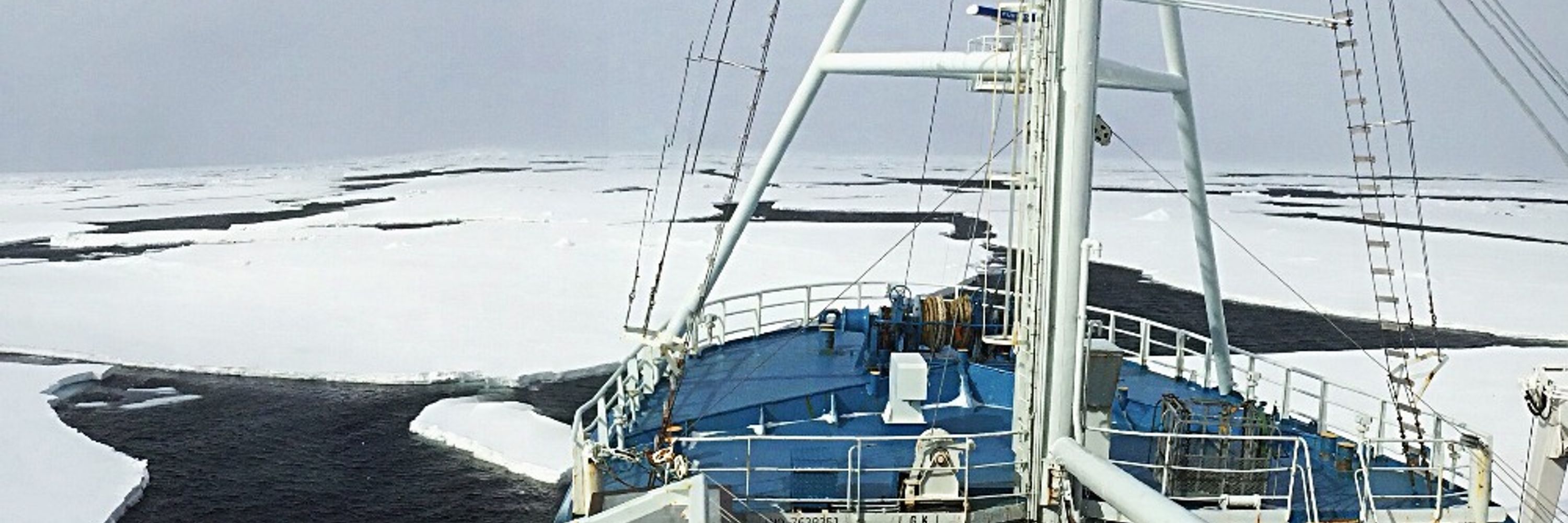
It is currently austral summer, which means that #Antarctic sea-ice extent is on its way to the annual minimum. This year will *not* be a new record low, partially due to very widespread ice cover in the Weddell Sea.
+ Another perspective zacklabe.com/antarctic-se...
+ Data doi.org/10.7265/b18j...
+ Another perspective zacklabe.com/antarctic-se...
+ Data doi.org/10.7265/b18j...

February 3, 2026 at 1:06 PM
It is currently austral summer, which means that #Antarctic sea-ice extent is on its way to the annual minimum. This year will *not* be a new record low, partially due to very widespread ice cover in the Weddell Sea.
+ Another perspective zacklabe.com/antarctic-se...
+ Data doi.org/10.7265/b18j...
+ Another perspective zacklabe.com/antarctic-se...
+ Data doi.org/10.7265/b18j...
This is the point I keep trying to get across in media interviews and conversations.
The science and data matter (obviously), but this is fundamentally a *people* story. These losses and lack of opportunities affect real people, real communities, and the impacts will last for decades.
The science and data matter (obviously), but this is fundamentally a *people* story. These losses and lack of opportunities affect real people, real communities, and the impacts will last for decades.

The state of the field is bad, actually.
The private sector seems to be still doing ok but the rest is hanging by a thread.
We have government shutdowns roughly every 2 months. Federal workers are treated like 3rd class citizens. NCAR as we know it may very well cease to exist.
The private sector seems to be still doing ok but the rest is hanging by a thread.
We have government shutdowns roughly every 2 months. Federal workers are treated like 3rd class citizens. NCAR as we know it may very well cease to exist.
February 2, 2026 at 10:43 PM
This is the point I keep trying to get across in media interviews and conversations.
The science and data matter (obviously), but this is fundamentally a *people* story. These losses and lack of opportunities affect real people, real communities, and the impacts will last for decades.
The science and data matter (obviously), but this is fundamentally a *people* story. These losses and lack of opportunities affect real people, real communities, and the impacts will last for decades.
Last month was the 13th lowest #Antarctic sea ice extent on record for the month of January.
This was 510,000 km² below the 1981-2010 January average. Data from the @nsidc.bsky.social: nsidc.org/data/seaice_...
This was 510,000 km² below the 1981-2010 January average. Data from the @nsidc.bsky.social: nsidc.org/data/seaice_...
February 2, 2026 at 10:28 PM
Last month was the 13th lowest #Antarctic sea ice extent on record for the month of January.
This was 510,000 km² below the 1981-2010 January average. Data from the @nsidc.bsky.social: nsidc.org/data/seaice_...
This was 510,000 km² below the 1981-2010 January average. Data from the @nsidc.bsky.social: nsidc.org/data/seaice_...
Monday ice update - #Arctic sea ice extent is currently the 3rd lowest on record (JAXA data)...
• about 270,000 km² below the 2010s mean
• about 910,000 km² below the 2000s mean
• about 1,480,000 km² below the 1990s mean
• about 1,910,000 km² below the 1980s mean
More: zacklabe.com/arctic-sea-i...
• about 270,000 km² below the 2010s mean
• about 910,000 km² below the 2000s mean
• about 1,480,000 km² below the 1990s mean
• about 1,910,000 km² below the 1980s mean
More: zacklabe.com/arctic-sea-i...

February 2, 2026 at 3:41 PM
Monday ice update - #Arctic sea ice extent is currently the 3rd lowest on record (JAXA data)...
• about 270,000 km² below the 2010s mean
• about 910,000 km² below the 2000s mean
• about 1,480,000 km² below the 1990s mean
• about 1,910,000 km² below the 1980s mean
More: zacklabe.com/arctic-sea-i...
• about 270,000 km² below the 2010s mean
• about 910,000 km² below the 2000s mean
• about 1,480,000 km² below the 1990s mean
• about 1,910,000 km² below the 1980s mean
More: zacklabe.com/arctic-sea-i...
A data-driven mosaic of our warming planet - now updated through 2025 🥵
Download graphic at zacklabe.com/climate-chan...
Download graphic at zacklabe.com/climate-chan...

February 2, 2026 at 12:39 PM
A data-driven mosaic of our warming planet - now updated through 2025 🥵
Download graphic at zacklabe.com/climate-chan...
Download graphic at zacklabe.com/climate-chan...
📉 Lowest mean Arctic sea-ice extent
📉 Lowest mean Arctic sea-ice volume
📉 Lowest mean Global sea-ice volume
📉 Lowest mean Arctic sea-ice volume
📉 Lowest mean Global sea-ice volume
My newest 'climate viz of the month' blog is out, which reports the latest annual mean sea ice stats and graphics for both poles: zacklabe.com/climate-viz-...
#DataViz #SciComm #OpenScience #OpenData
#DataViz #SciComm #OpenScience #OpenData

Climate Viz of the Month
December 2025 Hi everyone. I am just getting back from the annual meeting of the American Meteorological Society, so this blog is a bit delayed. As someone who loves snow and cold, I was excited to…
zacklabe.com
February 2, 2026 at 1:25 AM
📉 Lowest mean Arctic sea-ice extent
📉 Lowest mean Arctic sea-ice volume
📉 Lowest mean Global sea-ice volume
📉 Lowest mean Arctic sea-ice volume
📉 Lowest mean Global sea-ice volume
My recent interview about Arctic warming, data visualization, and the art of science communication - delphizero.substack.com/p/zack

Letting the Ice Speak
Climate scientist Zach Labe talks about Arctic warming, data visualization, and the art of science communication.
delphizero.substack.com
February 1, 2026 at 8:01 PM
My recent interview about Arctic warming, data visualization, and the art of science communication - delphizero.substack.com/p/zack
Large departures in #Arctic sea ice continue around Baffin Bay and the Labrador Sea, as well as the Barents Sea and Sea of Okhotsk. Resulting from the recent weather pattern, Bering Sea ice has a sharp locational gradient.
+ Concentration = fraction of sea ice
+ Graphic zacklabe.com/arctic-sea-i...
+ Concentration = fraction of sea ice
+ Graphic zacklabe.com/arctic-sea-i...

February 1, 2026 at 6:29 PM
Large departures in #Arctic sea ice continue around Baffin Bay and the Labrador Sea, as well as the Barents Sea and Sea of Okhotsk. Resulting from the recent weather pattern, Bering Sea ice has a sharp locational gradient.
+ Concentration = fraction of sea ice
+ Graphic zacklabe.com/arctic-sea-i...
+ Concentration = fraction of sea ice
+ Graphic zacklabe.com/arctic-sea-i...
ICYMI - two unique job opportunities open at @climatecentral.org:
+ Climate Data Scientist (closing soon!): www.climatecentral.org/open-positio...
+ Associate Product Manager: www.climatecentral.org/open-positio...
+ Climate Data Scientist (closing soon!): www.climatecentral.org/open-positio...
+ Associate Product Manager: www.climatecentral.org/open-positio...
February 1, 2026 at 2:41 PM
ICYMI - two unique job opportunities open at @climatecentral.org:
+ Climate Data Scientist (closing soon!): www.climatecentral.org/open-positio...
+ Associate Product Manager: www.climatecentral.org/open-positio...
+ Climate Data Scientist (closing soon!): www.climatecentral.org/open-positio...
+ Associate Product Manager: www.climatecentral.org/open-positio...
Welcome to February! Here's a look at how temperatures have changed around our planet over the last four decades...
Data from doi.org/10.24381/cds...
Data from doi.org/10.24381/cds...

February 1, 2026 at 2:00 PM
Welcome to February! Here's a look at how temperatures have changed around our planet over the last four decades...
Data from doi.org/10.24381/cds...
Data from doi.org/10.24381/cds...