


Yaakovweather.bsky.social
@yaakovweather.bsky.social
Reposted by Yaakovweather.bsky.social


Reposted by Yaakovweather.bsky.social

Record warmth far outpaced cold again last year: www.washingtonpost.com/weather/2026...

January 7, 2026 at 3:21 PM
Record warmth far outpaced cold again last year: www.washingtonpost.com/weather/2026...
Reposted by Yaakovweather.bsky.social

Definitive movement NNE now

October 28, 2025 at 5:58 AM
Definitive movement NNE now
Reposted by Yaakovweather.bsky.social
Updated track map. Starting to drift bit northward - part steering, part cyclonic wobble

October 28, 2025 at 3:17 AM
Updated track map. Starting to drift bit northward - part steering, part cyclonic wobble
Reposted by Yaakovweather.bsky.social

SSTs in the region where #Melissa has been developing are well above average - even compared to the past 30 years of warmer sea. Interestingly, also shear in the part of the world has been fairly consistently low (compared to 1950 onwards) since August... bit of a "loaded gun" you could argue...


October 26, 2025 at 12:43 PM
SSTs in the region where #Melissa has been developing are well above average - even compared to the past 30 years of warmer sea. Interestingly, also shear in the part of the world has been fairly consistently low (compared to 1950 onwards) since August... bit of a "loaded gun" you could argue...
Reposted by Yaakovweather.bsky.social

A 2017 paper reassessed the history of the Advanced Dvorak Technique (ADT) for global storms since 1979. As of 10:30pm ET on October 27, #Melissa is now *unofficially* only behind 2015's Hurricane Patricia (Eastern Pacific) for highest ADT in the past 46 years.
journals.ametsoc.org/view/journal...
journals.ametsoc.org/view/journal...

October 28, 2025 at 2:38 AM
A 2017 paper reassessed the history of the Advanced Dvorak Technique (ADT) for global storms since 1979. As of 10:30pm ET on October 27, #Melissa is now *unofficially* only behind 2015's Hurricane Patricia (Eastern Pacific) for highest ADT in the past 46 years.
journals.ametsoc.org/view/journal...
journals.ametsoc.org/view/journal...
Reposted by Yaakovweather.bsky.social

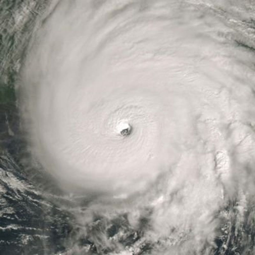
For posterity... Melissa's terrifying perfection: T8.6 initial intensity from the Automated Dvorak Technique.
Quite a thing to witness.
tropic.ssec.wisc.edu/real-time/ad...
Quite a thing to witness.
tropic.ssec.wisc.edu/real-time/ad...
October 28, 2025 at 3:24 AM
For posterity... Melissa's terrifying perfection: T8.6 initial intensity from the Automated Dvorak Technique.
Quite a thing to witness.
tropic.ssec.wisc.edu/real-time/ad...
Quite a thing to witness.
tropic.ssec.wisc.edu/real-time/ad...
Reposted by Yaakovweather.bsky.social
#Melissa has impressive outflow and upper divergence beginning as it interacts with the oncoming upper trough. This may allow for another unfortunate burst of intensification (barring an EWRC) as it approaches Jamaica
October 28, 2025 at 4:18 AM
#Melissa has impressive outflow and upper divergence beginning as it interacts with the oncoming upper trough. This may allow for another unfortunate burst of intensification (barring an EWRC) as it approaches Jamaica
Reposted by Yaakovweather.bsky.social

Just a follow up to say this did end up verifying:
AT 5pm Oct 25th, #Melissa was at 16.6N 75.5W.
By 11pm Oct 26th, #Melissa was at 16.3N 77.7W.
Just enough S of due W motion to delay serious rainfall hazards in #Jamaica temporary, though onset of catastrophic rainfall impacts likely today.
AT 5pm Oct 25th, #Melissa was at 16.6N 75.5W.
By 11pm Oct 26th, #Melissa was at 16.3N 77.7W.
Just enough S of due W motion to delay serious rainfall hazards in #Jamaica temporary, though onset of catastrophic rainfall impacts likely today.


October 27, 2025 at 5:20 PM
Reposted by Yaakovweather.bsky.social

I mentioned the Cuba-Hatteras Hurricane of late October 1837 a short time ago, here is my take on it. A major hurricane in Cuba. Melissa likely won't [but I did not say definitely not] duplicate it nor go as far west, as this was a very unusual late season hurricane.

October 22, 2025 at 2:11 PM
I mentioned the Cuba-Hatteras Hurricane of late October 1837 a short time ago, here is my take on it. A major hurricane in Cuba. Melissa likely won't [but I did not say definitely not] duplicate it nor go as far west, as this was a very unusual late season hurricane.
Reposted by Yaakovweather.bsky.social

Melissa's peak winds could "weaken slightly" before landfall. That could happen if it replaces its eyewall in an "eyewall replacement cycle".
But that would make Melissa's wind field *larger*, even while its peak winds tick down a tad.
That's what happened when Maria hit Puerto Rico in 2017.
But that would make Melissa's wind field *larger*, even while its peak winds tick down a tad.
That's what happened when Maria hit Puerto Rico in 2017.

October 27, 2025 at 12:50 PM
Melissa's peak winds could "weaken slightly" before landfall. That could happen if it replaces its eyewall in an "eyewall replacement cycle".
But that would make Melissa's wind field *larger*, even while its peak winds tick down a tad.
That's what happened when Maria hit Puerto Rico in 2017.
But that would make Melissa's wind field *larger*, even while its peak winds tick down a tad.
That's what happened when Maria hit Puerto Rico in 2017.
Reposted by Yaakovweather.bsky.social

NOAA TDR showing evidence that a secondary eyewall is beginning to form, seen by the ring of larger vorticity and vertical velocities outside the inner eyewall. This signals Melissa has likely peaked in intensity, but the inner core wind field will begin to expand.

October 27, 2025 at 12:54 PM
NOAA TDR showing evidence that a secondary eyewall is beginning to form, seen by the ring of larger vorticity and vertical velocities outside the inner eyewall. This signals Melissa has likely peaked in intensity, but the inner core wind field will begin to expand.
Reposted by Yaakovweather.bsky.social

Major European institutes join race to save US science data.
Thank goodness!
www.nature.com/articles/d41...
Thank goodness!
www.nature.com/articles/d41...

Major European institutes join race to save US science data
As the administration of US President Donald Trump slashes budgets, crucial climate and other data sets could disappear.
www.nature.com
April 25, 2025 at 1:46 PM
Major European institutes join race to save US science data.
Thank goodness!
www.nature.com/articles/d41...
Thank goodness!
www.nature.com/articles/d41...
Reposted by Yaakovweather.bsky.social
NWS has confirmed 29 tornadoes from last weekend through Monday's round of severe weather in 13 states in the South, Midwest. That includes 3 rated EF2.
Damage surveys continue, so that total will climb higher, as yet another severe outbreak targets the region starting later tonight.
Damage surveys continue, so that total will climb higher, as yet another severe outbreak targets the region starting later tonight.

April 1, 2025 at 11:45 AM
NWS has confirmed 29 tornadoes from last weekend through Monday's round of severe weather in 13 states in the South, Midwest. That includes 3 rated EF2.
Damage surveys continue, so that total will climb higher, as yet another severe outbreak targets the region starting later tonight.
Damage surveys continue, so that total will climb higher, as yet another severe outbreak targets the region starting later tonight.
Reposted by Yaakovweather.bsky.social
MJO strength peaks in March and can be a time of ENSO transition. It came and went with near-constant EWBs. La Niña is still in control atmospherically, and without an overbearing warm pool (such as 2023's), it seems El Niño this year is becoming increasingly unlikely

April 1, 2025 at 2:44 PM
MJO strength peaks in March and can be a time of ENSO transition. It came and went with near-constant EWBs. La Niña is still in control atmospherically, and without an overbearing warm pool (such as 2023's), it seems El Niño this year is becoming increasingly unlikely
Reposted by Yaakovweather.bsky.social
Milton was also the 4th most intense Atlantic hurricane in recorded history as measured by central pressure. It reached 895 mb off the northwest coast of the Yucatán Peninsula in the Gulf of Mexico... within range of the radar in Sabancuy, Mexico. bmcnoldy.earth.miami.edu/tropics/radar/
April 1, 2025 at 3:04 PM
Milton was also the 4th most intense Atlantic hurricane in recorded history as measured by central pressure. It reached 895 mb off the northwest coast of the Yucatán Peninsula in the Gulf of Mexico... within range of the radar in Sabancuy, Mexico. bmcnoldy.earth.miami.edu/tropics/radar/
Reposted by Yaakovweather.bsky.social

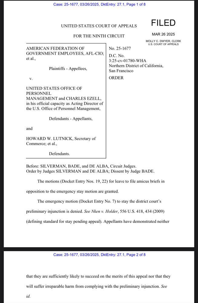
JUST IN: The 9th circuit court of appeals won’t clear the way for the mass firing of probationary employees at six key federal departments, leaving in place a lower court’s order reinstating thousands of terminated workers.
March 27, 2025 at 12:57 AM
JUST IN: The 9th circuit court of appeals won’t clear the way for the mass firing of probationary employees at six key federal departments, leaving in place a lower court’s order reinstating thousands of terminated workers.
Reposted by Yaakovweather.bsky.social

It's been 6 months since Hurricane #Helene. Here are JUST SOME of the astounding numbers I've gathered
- 16,200,000 people lost power
- 42 trillion gallons of water fell
- 4,562 cell towers knocked out
- 125,000 homes damaged
- 822,000 acres of forest destroyed
www.accuweather.com/en/hurricane...
- 16,200,000 people lost power
- 42 trillion gallons of water fell
- 4,562 cell towers knocked out
- 125,000 homes damaged
- 822,000 acres of forest destroyed
www.accuweather.com/en/hurricane...
March 26, 2025 at 4:02 PM
It's been 6 months since Hurricane #Helene. Here are JUST SOME of the astounding numbers I've gathered
- 16,200,000 people lost power
- 42 trillion gallons of water fell
- 4,562 cell towers knocked out
- 125,000 homes damaged
- 822,000 acres of forest destroyed
www.accuweather.com/en/hurricane...
- 16,200,000 people lost power
- 42 trillion gallons of water fell
- 4,562 cell towers knocked out
- 125,000 homes damaged
- 822,000 acres of forest destroyed
www.accuweather.com/en/hurricane...
Reposted by Yaakovweather.bsky.social

The greatest loss of data is in the Midwest, where forecasts of the timing and strength of low pressure troughs dominate steering of landfalling Gulf of Mexico hurricanes. It's plausible this lack of data could make a NHC 3-day cone of uncertainty to be centered over Mobile instead of New Orleans.

I’m keeping a running upperair observation status page on my website.
I have additional metadata like reason for degradation, degradation type, when the degradation began, etc. In a coming update you will be able to read those things by clicking on the site.
www.stormscale.io/spc/upperair...
I have additional metadata like reason for degradation, degradation type, when the degradation began, etc. In a coming update you will be able to read those things by clicking on the site.
www.stormscale.io/spc/upperair...

March 26, 2025 at 4:16 PM
The greatest loss of data is in the Midwest, where forecasts of the timing and strength of low pressure troughs dominate steering of landfalling Gulf of Mexico hurricanes. It's plausible this lack of data could make a NHC 3-day cone of uncertainty to be centered over Mobile instead of New Orleans.
Reposted by Yaakovweather.bsky.social

A small summary about climate change and tornado trends in the CONUS:
1. Fewer days with tornadoes but bigger tornado outbreaks when they happen.
2. Tornadoes in the summer ⬇️ winter ⬆️.
3. Some shift in the alley maximum eastward.
If you have more, or if something is inaccurate, please share.
1. Fewer days with tornadoes but bigger tornado outbreaks when they happen.
2. Tornadoes in the summer ⬇️ winter ⬆️.
3. Some shift in the alley maximum eastward.
If you have more, or if something is inaccurate, please share.
March 24, 2025 at 1:50 PM
A small summary about climate change and tornado trends in the CONUS:
1. Fewer days with tornadoes but bigger tornado outbreaks when they happen.
2. Tornadoes in the summer ⬇️ winter ⬆️.
3. Some shift in the alley maximum eastward.
If you have more, or if something is inaccurate, please share.
1. Fewer days with tornadoes but bigger tornado outbreaks when they happen.
2. Tornadoes in the summer ⬇️ winter ⬆️.
3. Some shift in the alley maximum eastward.
If you have more, or if something is inaccurate, please share.
Reposted by Yaakovweather.bsky.social

Sudden stratospheric warmings (SSWs) are extreme events, but the current SSW (very likely an FSW, final stratospheric warming) is turning into a *properly* extreme event – likely to set a variety of records – have a click around the plots/variables here ozonewatch.gsfc.nasa.gov/meteorology/...
NASA Ozone Watch: 2024 Arctic MERRA-2 Wind
2024 Arctic MERRA-2 Wind
ozonewatch.gsfc.nasa.gov
March 18, 2025 at 5:48 PM
Sudden stratospheric warmings (SSWs) are extreme events, but the current SSW (very likely an FSW, final stratospheric warming) is turning into a *properly* extreme event – likely to set a variety of records – have a click around the plots/variables here ozonewatch.gsfc.nasa.gov/meteorology/...
Reposted by Yaakovweather.bsky.social

The early April -PNA/-NAO pattern is imho largely being triggered by low frequency forcing from the Western Tropical Pacific & downward propagation of stratospheric circulation anomalies from the preceding final warming event.
There’s probably more of this where it came from in April.
There’s probably more of this where it came from in April.


March 25, 2025 at 12:19 PM
The early April -PNA/-NAO pattern is imho largely being triggered by low frequency forcing from the Western Tropical Pacific & downward propagation of stratospheric circulation anomalies from the preceding final warming event.
There’s probably more of this where it came from in April.
There’s probably more of this where it came from in April.
Reposted by Yaakovweather.bsky.social

The stratospheric polar vortex is set to weaken further in the coming days putting the 10mb u-wind near -30m/s. That value would represent the strongest reversal since the SSW of March 2016 and greatest reversal so late in the season since MERRA2 records began in the 1970s.

March 25, 2025 at 10:42 PM
The stratospheric polar vortex is set to weaken further in the coming days putting the 10mb u-wind near -30m/s. That value would represent the strongest reversal since the SSW of March 2016 and greatest reversal so late in the season since MERRA2 records began in the 1970s.
Reposted by Yaakovweather.bsky.social
The last soaking rain in Corpus Christi, Texas, was Jan. 9, almost 11 weeks ago. No measurable rain this month, so far.
So, it only stands to reason they're in the second highest level of flooding rainfall threat through early Friday AM, per NWS/WPC.
Typical Texas feast or famine rain scenario.
So, it only stands to reason they're in the second highest level of flooding rainfall threat through early Friday AM, per NWS/WPC.
Typical Texas feast or famine rain scenario.


March 26, 2025 at 10:45 AM
The last soaking rain in Corpus Christi, Texas, was Jan. 9, almost 11 weeks ago. No measurable rain this month, so far.
So, it only stands to reason they're in the second highest level of flooding rainfall threat through early Friday AM, per NWS/WPC.
Typical Texas feast or famine rain scenario.
So, it only stands to reason they're in the second highest level of flooding rainfall threat through early Friday AM, per NWS/WPC.
Typical Texas feast or famine rain scenario.
Reposted by Yaakovweather.bsky.social

The WPC days 3-7 verification for March 14, 2025.
It doesn’t get much better than this.
It doesn’t get much better than this.
March 15, 2025 at 9:49 PM
The WPC days 3-7 verification for March 14, 2025.
It doesn’t get much better than this.
It doesn’t get much better than this.