


Anthony Masiello
@antmasiello.bsky.social
Climate, weather, sub-seasonal to seasonal processes/forecasting. Music, song writing, dad. Located in Burlington, NJ.
Natural variability, in low frequency states of atmospheric circulation, is becoming increasingly likely as the main explanation for the North Atlantic warming hole.

The Atlantic's warming hole is not a sign of the AMOC weakening, a new study suggests 🌊🧪: ocean2climate.org/2025/11/12/t...

The Atlantic’s ‘Warming Hole’ Isn’t What You Think: 5 Surprising Truths From New Climate Research
This blog post and the “Deep Drive” podcast on a new paper “Atmosphere-driven processes in shaping long-term climate variability in Greenland and the broader subpolar North Atlant…
ocean2climate.org
November 12, 2025 at 4:10 PM
Natural variability, in low frequency states of atmospheric circulation, is becoming increasingly likely as the main explanation for the North Atlantic warming hole.
I'm too stupid to help myself, but I keep checking the sky to the north here in cloudy, light-pollution filled NJ. lol
November 12, 2025 at 1:27 AM
I'm too stupid to help myself, but I keep checking the sky to the north here in cloudy, light-pollution filled NJ. lol
Significant snow squall across PA and I-80. These are notorious accident producers.
November 11, 2025 at 2:51 AM
Significant snow squall across PA and I-80. These are notorious accident producers.
Reposted by Anthony Masiello

Reposted by Anthony Masiello

At 10:15 PM EST, Leisuretowne [Burlington Co, NJ] Trained Spotter reports Tstm Wnd Dmg. Multiple large tree limbs down on a house leading to roof damage. Time estimated from radar. #njwx Link
November 6, 2025 at 3:46 AM
At 10:15 PM EST, Leisuretowne [Burlington Co, NJ] Trained Spotter reports Tstm Wnd Dmg. Multiple large tree limbs down on a house leading to roof damage. Time estimated from radar. #njwx Link
Reposted by Anthony Masiello
READING/SPAATZ FLD,PA (RDG) ASOS reports gust of 53 knots (61.0 mph) from WNW @ 0254Z -- KRDG 060254Z 29029G53KT 10SM -RA SCT043 SCT060 BKN080 16/08 A2972 RMK AO2 PK WND 31053/0254 RAB0158 SLP067 P0001 60001 T01560083 53021
November 6, 2025 at 2:57 AM
READING/SPAATZ FLD,PA (RDG) ASOS reports gust of 53 knots (61.0 mph) from WNW @ 0254Z -- KRDG 060254Z 29029G53KT 10SM -RA SCT043 SCT060 BKN080 16/08 A2972 RMK AO2 PK WND 31053/0254 RAB0158 SLP067 P0001 60001 T01560083 53021
Reposted by Anthony Masiello

MIDDLETOWN/OLMSTED,PA (MDT) ASOS reports gust of 54 knots (62.1 mph) from NW @ 0141Z -- KMDT 060156Z 30020G36KT 6SM -RA SCT030 BKN065 OVC100 13/10 A2972 RMK AO2 PK WND 31054/0141 RAB42 SLP064 P0005 T01280100
November 6, 2025 at 2:00 AM
MIDDLETOWN/OLMSTED,PA (MDT) ASOS reports gust of 54 knots (62.1 mph) from NW @ 0141Z -- KMDT 060156Z 30020G36KT 6SM -RA SCT030 BKN065 OVC100 13/10 A2972 RMK AO2 PK WND 31054/0141 RAB42 SLP064 P0005 T01280100
Reposted by Anthony Masiello
CLEARFIELD-LAWRENCE APT(WAS N97),PA (FIG) ASOS reports gust of 56 knots (64.4 mph) from NNW @ 0036Z -- KFIG 060054Z AUTO 31024G40KT 10SM -RA SCT022 BKN029 OVC039 09/06 A2979 RMK AO2 PK WND 33056/0036 RAE11B36 PRESRR SLP096 P0003 T00940061
November 6, 2025 at 12:57 AM
CLEARFIELD-LAWRENCE APT(WAS N97),PA (FIG) ASOS reports gust of 56 knots (64.4 mph) from NNW @ 0036Z -- KFIG 060054Z AUTO 31024G40KT 10SM -RA SCT022 BKN029 OVC039 09/06 A2979 RMK AO2 PK WND 33056/0036 RAE11B36 PRESRR SLP096 P0003 T00940061
@lawliberg.bsky.social voting was a lot smoother this morning in Northwest Burlington but alas it's not a presidential election. There were two booths with two stations each to vote where I go. I suppose that's sufficient for now. 🤷♂️
November 4, 2025 at 2:58 PM
@lawliberg.bsky.social voting was a lot smoother this morning in Northwest Burlington but alas it's not a presidential election. There were two booths with two stations each to vote where I go. I suppose that's sufficient for now. 🤷♂️
Reposted by Anthony Masiello

The Advanced Dvorak Technique (ADT) satellite-derived intensity estimate peaked at 185 knots for #Melissa -- which, according to the developer at CIMSS, is the highest value to date for any tropical cyclone.

October 28, 2025 at 10:41 PM
The Advanced Dvorak Technique (ADT) satellite-derived intensity estimate peaked at 185 knots for #Melissa -- which, according to the developer at CIMSS, is the highest value to date for any tropical cyclone.
Descending mesoscale inflow jets in close proximity to core that work with the core or non-perturbing Vortex Rossby Waves, all a possibility with Melissa's ability to sustain/resist classic ERC so far. Experts will soon dive into the data to let us know. For now, we speculate.
October 28, 2025 at 12:43 PM
Descending mesoscale inflow jets in close proximity to core that work with the core or non-perturbing Vortex Rossby Waves, all a possibility with Melissa's ability to sustain/resist classic ERC so far. Experts will soon dive into the data to let us know. For now, we speculate.
Reposted by Anthony Masiello

October 20, 2025 at 12:22 AM
Reposted by Anthony Masiello

On Oct. 16, 1987, southern Britain’s landscape was unrecognizable. Overnight, the country had been hit by its fiercest storm in more than 300 years where at least 18 people were killed. No one — not even Britain’s trusted weather forecasters — had seen it coming.

How the UK’s Hurricane-Strength Storm of 1987 Became a Famous Weather Forecasting Failure
The Great Storm of 1987 was a forecasting blunder that left at least 18 people dead, felled 15 million trees and caused a billion pounds’ worth of damage.
nyti.ms
October 15, 2025 at 4:40 PM
On Oct. 16, 1987, southern Britain’s landscape was unrecognizable. Overnight, the country had been hit by its fiercest storm in more than 300 years where at least 18 people were killed. No one — not even Britain’s trusted weather forecasters — had seen it coming.
Whether you are in the Outer Banks or up in New England, much of the Northeast US Coastal Plain is seeing northeasterly wind. Locally here in NJ, the LLJ will peak this evening/tonight before moving out/weakening tomorrow morning.

October 12, 2025 at 3:38 PM
Whether you are in the Outer Banks or up in New England, much of the Northeast US Coastal Plain is seeing northeasterly wind. Locally here in NJ, the LLJ will peak this evening/tonight before moving out/weakening tomorrow morning.
Bethany Beach, DE and Barnegat, NJ wave heights plots this morning.


October 12, 2025 at 3:03 PM
Bethany Beach, DE and Barnegat, NJ wave heights plots this morning.
You can get seasick watching the Cape May Marina webcam in the wind: capemaymarina.com/live-cameras/

Live Cameras - Cape May Marina
capemaymarina.com
October 12, 2025 at 2:44 PM
You can get seasick watching the Cape May Marina webcam in the wind: capemaymarina.com/live-cameras/
I have been enjoying watching the visible loop of the circulation off the NC/SC coastline this morning. The 12z analysis has a 992mb low here.
October 12, 2025 at 1:54 PM
I have been enjoying watching the visible loop of the circulation off the NC/SC coastline this morning. The 12z analysis has a 992mb low here.
Reposted by Anthony Masiello

New surge forecasts are in... some up, some down, most same.
Big news: Cape May is now forecast to have the highest gauge level in its 25-year record. Lewes, DE has fallen from #3 to #7.
Big news: Cape May is now forecast to have the highest gauge level in its 25-year record. Lewes, DE has fallen from #3 to #7.
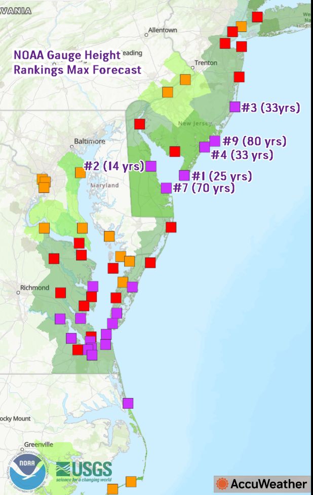
October 11, 2025 at 2:15 PM
New surge forecasts are in... some up, some down, most same.
Big news: Cape May is now forecast to have the highest gauge level in its 25-year record. Lewes, DE has fallen from #3 to #7.
Big news: Cape May is now forecast to have the highest gauge level in its 25-year record. Lewes, DE has fallen from #3 to #7.
The current forecast at Cape May Harbor Sunday afternoon has major flooding. Uh oh.

October 10, 2025 at 2:08 PM
The current forecast at Cape May Harbor Sunday afternoon has major flooding. Uh oh.
A nor'easter is becoming likely this weekend/early next week for the Mid Atlantic. The idea of the northern stream s/w not cutting off to interact with the coastal storm is losing support.
October 8, 2025 at 6:52 PM
A nor'easter is becoming likely this weekend/early next week for the Mid Atlantic. The idea of the northern stream s/w not cutting off to interact with the coastal storm is losing support.
This weekend's partial to full phase is going to be fun.
October 7, 2025 at 11:38 PM
This weekend's partial to full phase is going to be fun.
I went to check these products this morning and forgot...oh right, of course. :( It's the end of an era in the stratosphere world: www.cpc.ncep.noaa.gov/products/str...
Climate Prediction Center - Stratosphere Home
www.cpc.ncep.noaa.gov
October 2, 2025 at 12:22 PM
I went to check these products this morning and forgot...oh right, of course. :( It's the end of an era in the stratosphere world: www.cpc.ncep.noaa.gov/products/str...
Seeing fallstreaks/hole punch signatures on the visible satellite this morning over NJ.
September 29, 2025 at 1:52 PM
Seeing fallstreaks/hole punch signatures on the visible satellite this morning over NJ.
Okay, tomorrow has my attention. I'll be at CHOP and distracted but will need to keep an eye on this.

September 25, 2025 at 1:36 AM
Okay, tomorrow has my attention. I'll be at CHOP and distracted but will need to keep an eye on this.
Having a child who's suffering from Henoch-Schönlein Purpura (HSP) is terrible. We're in the midst of it. Have any of you had experience with this? I never heard of it until we went to the ER Monday.
September 17, 2025 at 11:22 PM
Having a child who's suffering from Henoch-Schönlein Purpura (HSP) is terrible. We're in the midst of it. Have any of you had experience with this? I never heard of it until we went to the ER Monday.