


Simon Lee
@simonleewx.com
Lecturer in Atmospheric Science, University of St Andrews. Large-scale weather & climate variability, prediction & change. simonleewx.com
Pinned
Simon Lee
@simonleewx.com
· Jan 10

📣 New paper with Lorenzo Polvani published in @agu.org GRL!
Increasing Frequency and Persistence of the Summertime Greenland High Regime Not Captured by a Seasonal Prediction Model Very Large Ensemble
Open access: doi.org/10.1029/2025...
@earthscista.bsky.social @lamont.columbia.edu
Increasing Frequency and Persistence of the Summertime Greenland High Regime Not Captured by a Seasonal Prediction Model Very Large Ensemble
Open access: doi.org/10.1029/2025...
@earthscista.bsky.social @lamont.columbia.edu
Reposted by Simon Lee

We’ve got a new dataset that’s hi-res and research ready: MESACLIP. Researchers used two supercomputers to create the MESACLIP dataset which features the Earth system in unprecedented detail, including snow cover and sea surface temperatures. Learn more: https://bit.ly/4rBK9bg

February 9, 2026 at 4:59 PM
We’ve got a new dataset that’s hi-res and research ready: MESACLIP. Researchers used two supercomputers to create the MESACLIP dataset which features the Earth system in unprecedented detail, including snow cover and sea surface temperatures. Learn more: https://bit.ly/4rBK9bg
Reposted by Simon Lee

Grazalema, Spain, received over 2,000 mm (78 inches) of rain in just the last 20 days.
Over a year’s worth of rain — and it’s only early February. This is hydrologically absurd.
Over a year’s worth of rain — and it’s only early February. This is hydrologically absurd.

February 9, 2026 at 4:11 PM
Grazalema, Spain, received over 2,000 mm (78 inches) of rain in just the last 20 days.
Over a year’s worth of rain — and it’s only early February. This is hydrologically absurd.
Over a year’s worth of rain — and it’s only early February. This is hydrologically absurd.
Reposted by Simon Lee
ERA5 daily-mean 10 hPa 60°N zonal-mean zonal wind time series plots, 1940/41 through present
simonleewx.com/10-hpa-60n-z...
simonleewx.com/10-hpa-60n-z...

February 4, 2026 at 5:52 PM
ERA5 daily-mean 10 hPa 60°N zonal-mean zonal wind time series plots, 1940/41 through present
simonleewx.com/10-hpa-60n-z...
simonleewx.com/10-hpa-60n-z...
ERA5 daily-mean 10 hPa 60°N zonal-mean zonal wind time series plots, 1940/41 through present
simonleewx.com/10-hpa-60n-z...
simonleewx.com/10-hpa-60n-z...
February 4, 2026 at 5:52 PM
ERA5 daily-mean 10 hPa 60°N zonal-mean zonal wind time series plots, 1940/41 through present
simonleewx.com/10-hpa-60n-z...
simonleewx.com/10-hpa-60n-z...
Reposted by Simon Lee

New all-time minimum sea level in the Baltic Sea!
The Föglö tide gauge measured just -71.6 cm below the mean level which is the lowest value ever recorded there. Records have been kept over 100 years, since 1924 (!).
The sea level is still decreasing. (1/3)
The Föglö tide gauge measured just -71.6 cm below the mean level which is the lowest value ever recorded there. Records have been kept over 100 years, since 1924 (!).
The sea level is still decreasing. (1/3)

February 4, 2026 at 10:12 AM
New all-time minimum sea level in the Baltic Sea!
The Föglö tide gauge measured just -71.6 cm below the mean level which is the lowest value ever recorded there. Records have been kept over 100 years, since 1924 (!).
The sea level is still decreasing. (1/3)
The Föglö tide gauge measured just -71.6 cm below the mean level which is the lowest value ever recorded there. Records have been kept over 100 years, since 1924 (!).
The sea level is still decreasing. (1/3)
The weather regime that on average brings the coldest weather is warming the fastest in a large part of northern Europe. In contrast, the weather regime that typically brings the warmest weather has warmed the slowest.
doi.org/10.1002/asl.... @mikarantane.bsky.social
doi.org/10.1002/asl.... @mikarantane.bsky.social

Is climate change responsible for increasingly frequent or severe cold events?
The evidence suggests it is not.
Instead, the impact of climate change is warmer winters and less severe cold events.
@hausfath.bsky.social has a great post on The Climate Brink talking about this.
The evidence suggests it is not.
Instead, the impact of climate change is warmer winters and less severe cold events.
@hausfath.bsky.social has a great post on The Climate Brink talking about this.

Fact check: Climate change is not making extreme cold more common
Sometimes it just gets cold
substack.com
February 3, 2026 at 2:59 PM
The weather regime that on average brings the coldest weather is warming the fastest in a large part of northern Europe. In contrast, the weather regime that typically brings the warmest weather has warmed the slowest.
doi.org/10.1002/asl.... @mikarantane.bsky.social
doi.org/10.1002/asl.... @mikarantane.bsky.social
Reposted by Simon Lee

While there *is* evidence of both "wetter wets" & "drier dries" in warming climate, temperatures are going almost universally in one direction: Up. We're just not seeing "colder colds."
Some interesting potential Arctic-related caveats still remain TBD, but that doesn't change big picture.
Some interesting potential Arctic-related caveats still remain TBD, but that doesn't change big picture.
Is climate change responsible for increasingly frequent or severe cold events?
The evidence suggests it is not.
Instead, the impact of climate change is warmer winters and less severe cold events.
@hausfath.bsky.social has a great post on The Climate Brink talking about this.
The evidence suggests it is not.
Instead, the impact of climate change is warmer winters and less severe cold events.
@hausfath.bsky.social has a great post on The Climate Brink talking about this.
Fact check: Climate change is not making extreme cold more common
Sometimes it just gets cold
substack.com
February 3, 2026 at 1:57 AM
While there *is* evidence of both "wetter wets" & "drier dries" in warming climate, temperatures are going almost universally in one direction: Up. We're just not seeing "colder colds."
Some interesting potential Arctic-related caveats still remain TBD, but that doesn't change big picture.
Some interesting potential Arctic-related caveats still remain TBD, but that doesn't change big picture.
Delighted to see this research in @rmets.org Weather!
Expressing probabilities could be the key for improved weather-based decision-making, according to new Met Office research.
Read more in our news release ⬇️
bit.ly/4qfyZYv
Read more in our news release ⬇️
bit.ly/4qfyZYv

February 3, 2026 at 1:55 PM
Delighted to see this research in @rmets.org Weather!
A sensible assessment of the science.

With cold outbreaks sweeping parts of the US, some have argued that climate change is to blame. But the proposed mechanism remains quite controversial in the scientific community, and the number of extreme cold events have been decreasing almost everywhere: www.theclimatebrink....

February 2, 2026 at 10:30 PM
A sensible assessment of the science.
Reposted by Simon Lee

It’s time for our annual reminder that, yes, you can have winter storms, record snowfall, and extreme cold even with global warming. Winter is getting warmer, but not so warm that snow and ice storms aren’t still possible. Are you surprised? Read our new article for more info. Link in comments.


February 2, 2026 at 8:03 PM
It’s time for our annual reminder that, yes, you can have winter storms, record snowfall, and extreme cold even with global warming. Winter is getting warmer, but not so warm that snow and ice storms aren’t still possible. Are you surprised? Read our new article for more info. Link in comments.
Reposted by Simon Lee

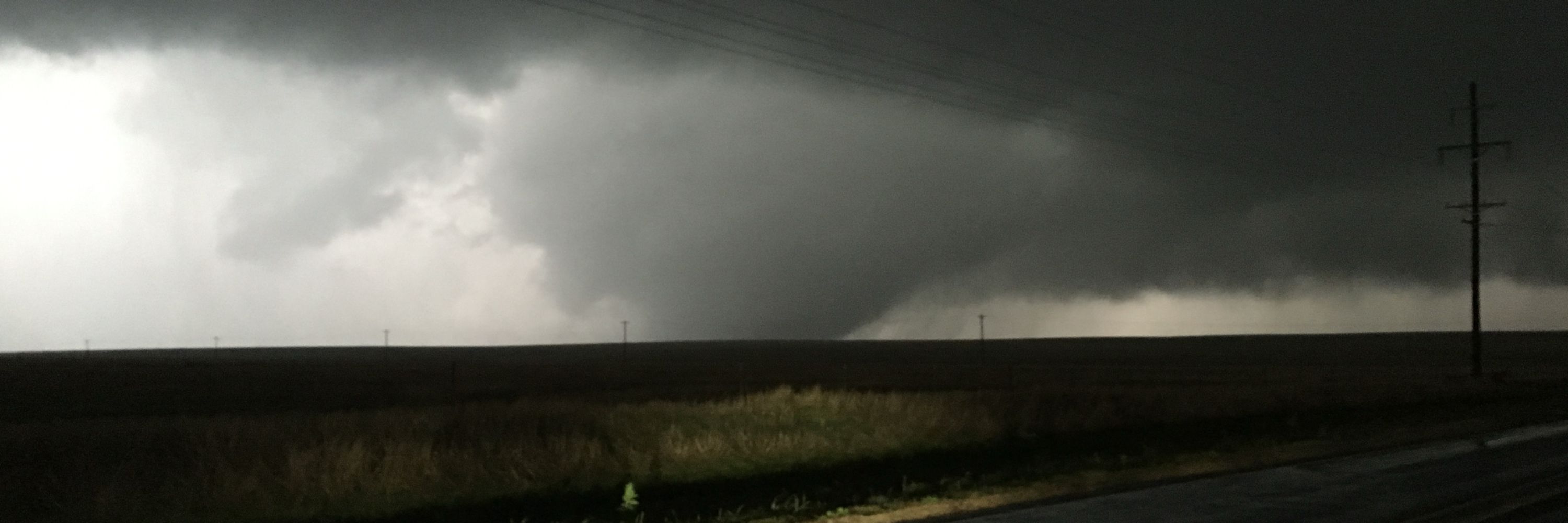
The deadly Cole, OK EF3 tornado from 04-19-2023. I couldn't believe the clear slot wrapped around this thing. This was a long day for central Oklahoma, and one in which I saw eight tornadoes! #Photography

January 29, 2026 at 11:24 PM
The deadly Cole, OK EF3 tornado from 04-19-2023. I couldn't believe the clear slot wrapped around this thing. This was a long day for central Oklahoma, and one in which I saw eight tornadoes! #Photography
Reposted by Simon Lee

New discussion paper just dropped that’s taken shall we say a little work to get this far … essd.copernicus.org/preprints/es... please be kind. Not on an at all sensitive topic in the slightest.

How well can we quantify when 1.5 °C of global warming has been exceeded?
Abstract. Parties to the 2015 Paris Agreement agreed to limit the long-term increase in global average temperature to well below 2 °C and pursue efforts to keep temperatures below 1.5 °C relative to p...
essd.copernicus.org
January 28, 2026 at 8:48 AM
New discussion paper just dropped that’s taken shall we say a little work to get this far … essd.copernicus.org/preprints/es... please be kind. Not on an at all sensitive topic in the slightest.
Reposted by Simon Lee
Kelvin-Helmholtz-Instabilität über der Nordsee am Freitag/Samstag, erzeugt durch eine Verwirblung im Lee des Riesengebirges (CZ):
January 28, 2026 at 8:17 AM
Kelvin-Helmholtz-Instabilität über der Nordsee am Freitag/Samstag, erzeugt durch eine Verwirblung im Lee des Riesengebirges (CZ):
Reposted by Simon Lee
The last 10 days (16th-25th January 2026) MSLP anomaly versus the second half of January 2014. Not terribly different.


January 27, 2026 at 9:54 PM
The last 10 days (16th-25th January 2026) MSLP anomaly versus the second half of January 2014. Not terribly different.
Reposted by Simon Lee

Several sites have provisionally set new January daily rainfall records, some are shown in the table below 👇
Katesbridge has provisionally recorded its wettest day on record, while Plymouth (Mountbatten) also saw a notable record at a site with over 100 years of observations
Katesbridge has provisionally recorded its wettest day on record, while Plymouth (Mountbatten) also saw a notable record at a site with over 100 years of observations

January 27, 2026 at 2:55 PM
Several sites have provisionally set new January daily rainfall records, some are shown in the table below 👇
Katesbridge has provisionally recorded its wettest day on record, while Plymouth (Mountbatten) also saw a notable record at a site with over 100 years of observations
Katesbridge has provisionally recorded its wettest day on record, while Plymouth (Mountbatten) also saw a notable record at a site with over 100 years of observations
Strong, moist southeasterly flow giving an unusual and spectacular example of orographic enhancement, leeward rain shadow, and a standing wave pattern.
We’ve been stuck in this pattern for an unusually long time now — the January-total rainfall map will be an unusual one!
We’ve been stuck in this pattern for an unusually long time now — the January-total rainfall map will be an unusual one!
January 27, 2026 at 8:33 PM
Strong, moist southeasterly flow giving an unusual and spectacular example of orographic enhancement, leeward rain shadow, and a standing wave pattern.
We’ve been stuck in this pattern for an unusually long time now — the January-total rainfall map will be an unusual one!
We’ve been stuck in this pattern for an unusually long time now — the January-total rainfall map will be an unusual one!
Storm Chandra currently bringing unusually strong winds from the east/southeast across the UK today, alongside heavy rain and snow in places.

January 27, 2026 at 11:39 AM
Storm Chandra currently bringing unusually strong winds from the east/southeast across the UK today, alongside heavy rain and snow in places.
"...Arctic-induced circulation responses are not robustly detected in observations and fully-coupled models. The dominant response to Arctic changes under global warming has been the reduction of cold extremes associated with decreased day-to-day temperature variability"
doi.org/10.1002/asl....
doi.org/10.1002/asl....

Detectable Human Influence on Reduced Day‐to‐Day Temperature Variability in the Cold Season Driven by Arctic Sea‐Ice Loss
Over recent decades, day-to-day temperature variability at Northern Hemisphere mid and high latitudes has decreased, especially in the autumn and winter seasons. It is unclear how much the observed r....
doi.org
January 27, 2026 at 11:09 AM
"...Arctic-induced circulation responses are not robustly detected in observations and fully-coupled models. The dominant response to Arctic changes under global warming has been the reduction of cold extremes associated with decreased day-to-day temperature variability"
doi.org/10.1002/asl....
doi.org/10.1002/asl....
Reposted by Simon Lee

EUMETSAT view: Ireland and UK at 0940 UTC. @simonleewx.com @drgeoffsmith.bsky.social @winchesterweather.bsky.social @wessexweather.net @wansteadweather.bsky.social @chadweather.bsky.social @fifeweather.co.uk @wgoodf.bsky.social @metoffice.gov.uk

January 27, 2026 at 10:15 AM
EUMETSAT view: Ireland and UK at 0940 UTC. @simonleewx.com @drgeoffsmith.bsky.social @winchesterweather.bsky.social @wessexweather.net @wansteadweather.bsky.social @chadweather.bsky.social @fifeweather.co.uk @wgoodf.bsky.social @metoffice.gov.uk
"...a jet stream analysis shows no pronounced weakening or increased waviness in the polar jet. Thus, the hypothesis that weaker temperature gradients slow down jet streams was not supported in our real-world climate scenarios."
doi.org/10.1175/JCLI...
doi.org/10.1175/JCLI...
January 26, 2026 at 11:51 AM
"...a jet stream analysis shows no pronounced weakening or increased waviness in the polar jet. Thus, the hypothesis that weaker temperature gradients slow down jet streams was not supported in our real-world climate scenarios."
doi.org/10.1175/JCLI...
doi.org/10.1175/JCLI...
The extreme cold across eastern N America is due to the Alaskan Ridge regime, which on average brings the coldest winter weather to this region.
Is this happening more often?
No. During the modern warming era, there has been no observed trend in the occurrence of this regime at this time of year.
Is this happening more often?
No. During the modern warming era, there has been no observed trend in the occurrence of this regime at this time of year.

January 23, 2026 at 4:59 PM
The extreme cold across eastern N America is due to the Alaskan Ridge regime, which on average brings the coldest winter weather to this region.
Is this happening more often?
No. During the modern warming era, there has been no observed trend in the occurrence of this regime at this time of year.
Is this happening more often?
No. During the modern warming era, there has been no observed trend in the occurrence of this regime at this time of year.
What's almost more depressing about The White House posting climate denialism are the apparently well-meaning replies which try to argue "it’s one of the predicted consequences of a warming Arctic destabilizing global weather systems" (or equivalent), which isn't the case either
January 23, 2026 at 4:05 PM
What's almost more depressing about The White House posting climate denialism are the apparently well-meaning replies which try to argue "it’s one of the predicted consequences of a warming Arctic destabilizing global weather systems" (or equivalent), which isn't the case either
Reposted by Simon Lee
METOP-B, 1002 UTC Overpass: @simonleewx.com @winchesterweather.bsky.social @wessexweather.net @wansteadweather.bsky.social @chadweather.bsky.social @fifeweather.co.uk @wgoodf.bsky.social @metoffice.gov.uk @weathermizu.bsky.social

January 23, 2026 at 10:31 AM
Reposted by Simon Lee

The @metoffice.gov.uk have just tweaked their app.
Improved: forecast maps scrolling better but not as clean as last app version. ‘Feels like’ temperature back on main carousel.
Not fixed yet: No wind gusts on carousel. Locations list still awful design. Warnings list & map should be more visible.
Improved: forecast maps scrolling better but not as clean as last app version. ‘Feels like’ temperature back on main carousel.
Not fixed yet: No wind gusts on carousel. Locations list still awful design. Warnings list & map should be more visible.
So… the @metoffice.gov.uk app redesign - is it just a bit worse or much much worse?
January 22, 2026 at 10:42 AM
The @metoffice.gov.uk have just tweaked their app.
Improved: forecast maps scrolling better but not as clean as last app version. ‘Feels like’ temperature back on main carousel.
Not fixed yet: No wind gusts on carousel. Locations list still awful design. Warnings list & map should be more visible.
Improved: forecast maps scrolling better but not as clean as last app version. ‘Feels like’ temperature back on main carousel.
Not fixed yet: No wind gusts on carousel. Locations list still awful design. Warnings list & map should be more visible.
High seas looking out from St Andrews this afternoon, with 30–40mph southeasterly winds onshore.

January 22, 2026 at 5:43 PM
High seas looking out from St Andrews this afternoon, with 30–40mph southeasterly winds onshore.