


Chuck Copeland 🌀
@nchurricane.com
• NC-Based Weather Enthusiast
• Created nchurricane.com in 2003
• Will sometimes post cat pictures (see @nchurricats.bsky.social for more)
• Freelance multimedia creator/full-time retail manager
#wx #wxsky #ncwx
• Created nchurricane.com in 2003
• Will sometimes post cat pictures (see @nchurricats.bsky.social for more)
• Freelance multimedia creator/full-time retail manager
#wx #wxsky #ncwx
Pinned
Chuck Copeland 🌀
@nchurricane.com
· Nov 14


#Introduction👋
I'm a #wx enthusiast, retail manager, freelance video/photo editor, #CatDad, & former racecar driver.
I run a #weather website, nchurricane.com.
My other accounts:
#VideoEditing ⛈️ - @chuckcopeland.com
#Cats 🐈 - @nchurricats.bsky.social
#Motorsports 🏁 - @ncracersgarage.bsky.social
I'm a #wx enthusiast, retail manager, freelance video/photo editor, #CatDad, & former racecar driver.
I run a #weather website, nchurricane.com.
My other accounts:
#VideoEditing ⛈️ - @chuckcopeland.com
#Cats 🐈 - @nchurricats.bsky.social
#Motorsports 🏁 - @ncracersgarage.bsky.social
I finally got around to getting MRMS data in my work-in-progress alpha-stage dashboard.
My biggest hurdle that I can't seem to get over is the colormap for IR and WV GOES images. I just can't seem to get it to look like I want.
My biggest hurdle that I can't seem to get over is the colormap for IR and WV GOES images. I just can't seem to get it to look like I want.
February 17, 2026 at 4:06 AM
I finally got around to getting MRMS data in my work-in-progress alpha-stage dashboard.
My biggest hurdle that I can't seem to get over is the colormap for IR and WV GOES images. I just can't seem to get it to look like I want.
My biggest hurdle that I can't seem to get over is the colormap for IR and WV GOES images. I just can't seem to get it to look like I want.
That last sentence. I've never known why that wasn't/couldn't be implemented. iNWS is simple and effective,

It still floors me that NWS never overcame the app hurdle. The argument 15 years ago was undue competition with the private sector, but I would've expected that barrier to have fallen with the massive uptake in apps vs websites. Even a public iNWS would be a tremendous service nowadays.
February 17, 2026 at 2:28 AM
That last sentence. I've never known why that wasn't/couldn't be implemented. iNWS is simple and effective,
Reposted by Chuck Copeland 🌀

A prominent Bluesky elder already hosts Jeopardy
How many followers for a prominent Bluesky elder to host Jeopardy
February 16, 2026 at 8:29 PM
A prominent Bluesky elder already hosts Jeopardy
iNWS says "Hi y'all."

February 16, 2026 at 2:55 AM
iNWS says "Hi y'all."

Reposted by Chuck Copeland 🌀

I think we saw a "few" snow reports on Saturday and Saturday night across North Carolina... #SpectrumNews1 #ncwx

February 1, 2026 at 7:47 PM
I think we saw a "few" snow reports on Saturday and Saturday night across North Carolina... #SpectrumNews1 #ncwx
Checking out the NOAA-20 VIIRS images, it's cool to see the barrier islands coated in #snow, too. #wx #ncwx
ge.ssec.wisc.edu/viirs-today/...
ge.ssec.wisc.edu/viirs-today/...

February 1, 2026 at 7:26 PM
Checking out the NOAA-20 VIIRS images, it's cool to see the barrier islands coated in #snow, too. #wx #ncwx
ge.ssec.wisc.edu/viirs-today/...
ge.ssec.wisc.edu/viirs-today/...
Reposted by Chuck Copeland 🌀

Here's our analysis of this weekend's snowfall totals across North Carolina. ❄️
Notably, portions of all 3 regions of the state (Mountains, Piedmont, and Coastal Plain) received more than a foot of snow!
Stay tuned for our full blog post writeup about this storm tomorrow. #ncwx
Notably, portions of all 3 regions of the state (Mountains, Piedmont, and Coastal Plain) received more than a foot of snow!
Stay tuned for our full blog post writeup about this storm tomorrow. #ncwx

February 1, 2026 at 7:20 PM
Here's our analysis of this weekend's snowfall totals across North Carolina. ❄️
Notably, portions of all 3 regions of the state (Mountains, Piedmont, and Coastal Plain) received more than a foot of snow!
Stay tuned for our full blog post writeup about this storm tomorrow. #ncwx
Notably, portions of all 3 regions of the state (Mountains, Piedmont, and Coastal Plain) received more than a foot of snow!
Stay tuned for our full blog post writeup about this storm tomorrow. #ncwx
February 1, 2026 at 6:10 PM
Drone footage over Winterville, NC showing #snow as far as the eye can see. A snowstorm to remember.
Officially measured just a touch over a foot at my location, with higher drifts. The biggest storm since March 1980 (December 1989 for the coast) for many parts of North Carolina.
#wx #wxsky #ncwx
Officially measured just a touch over a foot at my location, with higher drifts. The biggest storm since March 1980 (December 1989 for the coast) for many parts of North Carolina.
#wx #wxsky #ncwx
February 1, 2026 at 3:42 PM
The @NWS has an awesome dashboard for finding pretty much any weather data for thousands of locations.
weather.gov/forecastpoints
You should bookmark it!
#ncwx #wx #wxsky #weather
weather.gov/forecastpoints
You should bookmark it!
#ncwx #wx #wxsky #weather
January 30, 2026 at 1:28 PM
The @NWS has an awesome dashboard for finding pretty much any weather data for thousands of locations.
weather.gov/forecastpoints
You should bookmark it!
#ncwx #wx #wxsky #weather
weather.gov/forecastpoints
You should bookmark it!
#ncwx #wx #wxsky #weather
Working on a personal dashboard using MetPy to produce satellite and radar loops.
Currently using THREDDS, but I want to know which source is better and faster to download (AWS, Google, etc)?
I'm also curious about how to get the colormaps correct for the colorized ABI channels. #ncwx
Currently using THREDDS, but I want to know which source is better and faster to download (AWS, Google, etc)?
I'm also curious about how to get the colormaps correct for the colorized ABI channels. #ncwx
January 29, 2026 at 5:43 PM
Working on a personal dashboard using MetPy to produce satellite and radar loops.
Currently using THREDDS, but I want to know which source is better and faster to download (AWS, Google, etc)?
I'm also curious about how to get the colormaps correct for the colorized ABI channels. #ncwx
Currently using THREDDS, but I want to know which source is better and faster to download (AWS, Google, etc)?
I'm also curious about how to get the colormaps correct for the colorized ABI channels. #ncwx


Reposted by Chuck Copeland 🌀

She didn’t make it that far outside before turning around 🐾

January 24, 2026 at 4:39 PM
She didn’t make it that far outside before turning around 🐾

Reposted by Chuck Copeland 🌀

/ A *PRELIMINARY* SNOWTOTES MAP
/ 4 SOUTHERN NEW ENGLAND BTWIXT SUN 1/25 & MON 1/26
/ THESE VALUES WILL ALMOST CERTAINLY CHANGE
/ & ITS BEEN DIFFICULT
/ 1 FEVERISH VIZION SAYS 2 THING
/ & THE NEXT SAYS ANOTHER
/ HARD 2 MAKE SENSE OF THESE V RAW, V POWERFUL VIZIONS
/ 4 SOUTHERN NEW ENGLAND BTWIXT SUN 1/25 & MON 1/26
/ THESE VALUES WILL ALMOST CERTAINLY CHANGE
/ & ITS BEEN DIFFICULT
/ 1 FEVERISH VIZION SAYS 2 THING
/ & THE NEXT SAYS ANOTHER
/ HARD 2 MAKE SENSE OF THESE V RAW, V POWERFUL VIZIONS

January 23, 2026 at 12:51 PM
/ A *PRELIMINARY* SNOWTOTES MAP
/ 4 SOUTHERN NEW ENGLAND BTWIXT SUN 1/25 & MON 1/26
/ THESE VALUES WILL ALMOST CERTAINLY CHANGE
/ & ITS BEEN DIFFICULT
/ 1 FEVERISH VIZION SAYS 2 THING
/ & THE NEXT SAYS ANOTHER
/ HARD 2 MAKE SENSE OF THESE V RAW, V POWERFUL VIZIONS
/ 4 SOUTHERN NEW ENGLAND BTWIXT SUN 1/25 & MON 1/26
/ THESE VALUES WILL ALMOST CERTAINLY CHANGE
/ & ITS BEEN DIFFICULT
/ 1 FEVERISH VIZION SAYS 2 THING
/ & THE NEXT SAYS ANOTHER
/ HARD 2 MAKE SENSE OF THESE V RAW, V POWERFUL VIZIONS

January 21, 2026 at 4:14 AM

Reposted by Chuck Copeland 🌀
My old bank just sent me a letter - to my current address - telling me that they need me to update my contact information because they don’t have my current address.
a woman in a pink cardigan stands in front of a white board with the words that makes no sense written on it
ALT: a woman in a pink cardigan stands in front of a white board with the words that makes no sense written on it
media.tenor.com
December 24, 2025 at 1:27 AM
My old bank just sent me a letter - to my current address - telling me that they need me to update my contact information because they don’t have my current address.
Reposted by Chuck Copeland 🌀

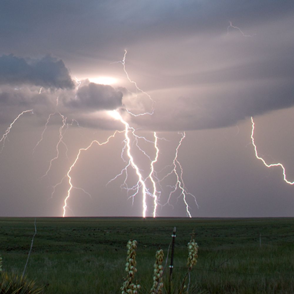
A rare November thunderstorm brings dramatic skies (and lightning) with it as the sun sets this evening.
Shot with a Samsung S23 Ultra. Edited in #DavinciResolve Studio.
#videography #timelapse #weather #mobilevideography
Shot with a Samsung S23 Ultra. Edited in #DavinciResolve Studio.
#videography #timelapse #weather #mobilevideography
November 22, 2025 at 10:50 PM
A rare November thunderstorm brings dramatic skies (and lightning) with it as the sun sets this evening.
Shot with a Samsung S23 Ultra. Edited in #DavinciResolve Studio.
#videography #timelapse #weather #mobilevideography
Shot with a Samsung S23 Ultra. Edited in #DavinciResolve Studio.
#videography #timelapse #weather #mobilevideography
I really wish I did not have to work tonight and had time to set up for this, but the Samsung did ok.
Seeing some incredible #aurora photos tonight.
Seeing some incredible #aurora photos tonight.
Tonight's #aurora definitely beats the one in May 2024 for my area in NC, USA. If the forecast comes to fruition, tomorrow's will be even better.
Incredible.
#astrophotography #photography
Incredible.
#astrophotography #photography

November 12, 2025 at 4:21 AM
I really wish I did not have to work tonight and had time to set up for this, but the Samsung did ok.
Seeing some incredible #aurora photos tonight.
Seeing some incredible #aurora photos tonight.