


Chuck Copeland 🌀
@nchurricane.com
• NC-Based Weather Enthusiast
• Created nchurricane.com in 2003
• Will sometimes post cat pictures (see @nchurricats.bsky.social for more)
• Freelance multimedia creator/full-time retail manager
#wx #wxsky #ncwx
• Created nchurricane.com in 2003
• Will sometimes post cat pictures (see @nchurricats.bsky.social for more)
• Freelance multimedia creator/full-time retail manager
#wx #wxsky #ncwx

November 11, 2025 at 6:05 AM

November 10, 2025 at 10:46 PM

Time-lapse of #Melissa becoming one of the strongest cyclones ever recorded in the Atlantic basin.
#hurricanemelissa #wx
#hurricanemelissa #wx
October 29, 2025 at 1:46 AM
Time-lapse of #Melissa becoming one of the strongest cyclones ever recorded in the Atlantic basin.
#hurricanemelissa #wx
#hurricanemelissa #wx
October 29, 2025 at 12:27 AM
The center of #Melissa is emerging back into the ocean.
The terrain of #Jamaica disrupted the core, but it will soon be fully over very warm waters as it makes its way towards a second landfall in eastern #Cuba.
As of the last advisory, it was still a category 4.
#hurricanemelissa
The terrain of #Jamaica disrupted the core, but it will soon be fully over very warm waters as it makes its way towards a second landfall in eastern #Cuba.
As of the last advisory, it was still a category 4.
#hurricanemelissa
October 28, 2025 at 9:36 PM
The center of #Melissa is emerging back into the ocean.
The terrain of #Jamaica disrupted the core, but it will soon be fully over very warm waters as it makes its way towards a second landfall in eastern #Cuba.
As of the last advisory, it was still a category 4.
#hurricanemelissa
The terrain of #Jamaica disrupted the core, but it will soon be fully over very warm waters as it makes its way towards a second landfall in eastern #Cuba.
As of the last advisory, it was still a category 4.
#hurricanemelissa
Hi-res view into eye of category 5 #Hurricane #Melissa just before landfall on the South Coast of #Jamaica this afternoon.
As seen from the Sentinel-2 satellite (link):
browser.dataspace.copernicus.eu?zoom=12&lat=...
As seen from the Sentinel-2 satellite (link):
browser.dataspace.copernicus.eu?zoom=12&lat=...

October 28, 2025 at 8:35 PM
Hi-res view into eye of category 5 #Hurricane #Melissa just before landfall on the South Coast of #Jamaica this afternoon.
As seen from the Sentinel-2 satellite (link):
browser.dataspace.copernicus.eu?zoom=12&lat=...
As seen from the Sentinel-2 satellite (link):
browser.dataspace.copernicus.eu?zoom=12&lat=...
Here's what #Melissa looks like from GOES-West. The compression doesn't do the stadium effect justice.
Here's the link to the CIRA SLIDER loop: rammb-slider.cira.colostate.edu?sat=goes-18&...
#hurricanemelissa
Here's the link to the CIRA SLIDER loop: rammb-slider.cira.colostate.edu?sat=goes-18&...
#hurricanemelissa
October 28, 2025 at 5:08 PM
Here's what #Melissa looks like from GOES-West. The compression doesn't do the stadium effect justice.
Here's the link to the CIRA SLIDER loop: rammb-slider.cira.colostate.edu?sat=goes-18&...
#hurricanemelissa
Here's the link to the CIRA SLIDER loop: rammb-slider.cira.colostate.edu?sat=goes-18&...
#hurricanemelissa
It looks like (barring a last minute wobble) that this will be the area of landfall for #Melissa, near the border of Westmoreland and St. Elizabeth Perishes.

October 28, 2025 at 4:48 PM
It looks like (barring a last minute wobble) that this will be the area of landfall for #Melissa, near the border of Westmoreland and St. Elizabeth Perishes.
I can't imagine what the surge levels will be in the Black River Bay with the path #Melissa is taking upon landfall.
Very bad angle vs the topography.
#hurricanemelissa #jamaica
Very bad angle vs the topography.
#hurricanemelissa #jamaica
October 28, 2025 at 3:51 PM
I can't imagine what the surge levels will be in the Black River Bay with the path #Melissa is taking upon landfall.
Very bad angle vs the topography.
#hurricanemelissa #jamaica
Very bad angle vs the topography.
#hurricanemelissa #jamaica
The 11am advisory from the NHC on #Melissa.
892 mb is the third lowest pressure recorded for an Atlantic hurricane, behind Wilma (2005) - 882mb and Gilbert (1998) - 888mb.
Official info: www.nhc.noaa.gov#Melissa
My Melissa Page: www.nchurricane.com/active/?stor...
#hurricanemelissa #jamaica
892 mb is the third lowest pressure recorded for an Atlantic hurricane, behind Wilma (2005) - 882mb and Gilbert (1998) - 888mb.
Official info: www.nhc.noaa.gov#Melissa
My Melissa Page: www.nchurricane.com/active/?stor...
#hurricanemelissa #jamaica

October 28, 2025 at 3:14 PM
The 11am advisory from the NHC on #Melissa.
892 mb is the third lowest pressure recorded for an Atlantic hurricane, behind Wilma (2005) - 882mb and Gilbert (1998) - 888mb.
Official info: www.nhc.noaa.gov#Melissa
My Melissa Page: www.nchurricane.com/active/?stor...
#hurricanemelissa #jamaica
892 mb is the third lowest pressure recorded for an Atlantic hurricane, behind Wilma (2005) - 882mb and Gilbert (1998) - 888mb.
Official info: www.nhc.noaa.gov#Melissa
My Melissa Page: www.nchurricane.com/active/?stor...
#hurricanemelissa #jamaica
A slight northward wobble as #Melissa makes final approach on the Jamaica coastline.
Source: www.weathernerds.org/satellite/?i...
#hurricanemelissa #jamaica
Source: www.weathernerds.org/satellite/?i...
#hurricanemelissa #jamaica
October 28, 2025 at 3:05 PM
A slight northward wobble as #Melissa makes final approach on the Jamaica coastline.
Source: www.weathernerds.org/satellite/?i...
#hurricanemelissa #jamaica
Source: www.weathernerds.org/satellite/?i...
#hurricanemelissa #jamaica
#Melissa getting close to landfall. Hurricane force winds likely affecting St. Elizabeth parish, including Treasure Beach by now.
#hurricanemelissa #jamaica
#hurricanemelissa #jamaica
October 28, 2025 at 2:49 PM
#Melissa getting close to landfall. Hurricane force winds likely affecting St. Elizabeth parish, including Treasure Beach by now.
#hurricanemelissa #jamaica
#hurricanemelissa #jamaica
Since the Jamaica Meteorological Service website is down, we have to go to the Pilón, Cuba radar to see #Melissa approach landfall in Jamaica.
www.insmet.cu/asp/genesis....
#hurricanemelissa #jamaica
www.insmet.cu/asp/genesis....
#hurricanemelissa #jamaica
October 28, 2025 at 2:29 PM
Since the Jamaica Meteorological Service website is down, we have to go to the Pilón, Cuba radar to see #Melissa approach landfall in Jamaica.
www.insmet.cu/asp/genesis....
#hurricanemelissa #jamaica
www.insmet.cu/asp/genesis....
#hurricanemelissa #jamaica
Latest update on #Melissa from the National Hurricane Center
Última actualización sobre Melissa del Centro Nacional de Huracanes
- www.nhc.noaa.gov#Melissa
#hurricanemelissa #huracánmelissa
Última actualización sobre Melissa del Centro Nacional de Huracanes
- www.nhc.noaa.gov#Melissa
#hurricanemelissa #huracánmelissa


October 28, 2025 at 2:19 PM
Latest update on #Melissa from the National Hurricane Center
Última actualización sobre Melissa del Centro Nacional de Huracanes
- www.nhc.noaa.gov#Melissa
#hurricanemelissa #huracánmelissa
Última actualización sobre Melissa del Centro Nacional de Huracanes
- www.nhc.noaa.gov#Melissa
#hurricanemelissa #huracánmelissa
#Hurricane force winds (64kt+) only extend 20-25 nautical miles (23-28 mi/37-46 km) from the center of #Melissa.
Anyone in the direct path *could* experience gusts to 180 or higher, but it will not be continuous. Higher elevations will have a better chance at higher gusts.
#hurricanemelissa
Anyone in the direct path *could* experience gusts to 180 or higher, but it will not be continuous. Higher elevations will have a better chance at higher gusts.
#hurricanemelissa


October 28, 2025 at 1:56 PM
#Hurricane force winds (64kt+) only extend 20-25 nautical miles (23-28 mi/37-46 km) from the center of #Melissa.
Anyone in the direct path *could* experience gusts to 180 or higher, but it will not be continuous. Higher elevations will have a better chance at higher gusts.
#hurricanemelissa
Anyone in the direct path *could* experience gusts to 180 or higher, but it will not be continuous. Higher elevations will have a better chance at higher gusts.
#hurricanemelissa
"Looks like they are heading out NW now. They were probably just trying to figure out the best path out, which is basically impossible when the entire eyewall is lit up with severe turb and lightning. Same thing happened on my Michael flight: "
x.com/JeremyDeHart...
#hurricanemelissa #melissa
x.com/JeremyDeHart...
#hurricanemelissa #melissa

October 28, 2025 at 1:34 PM
"Looks like they are heading out NW now. They were probably just trying to figure out the best path out, which is basically impossible when the entire eyewall is lit up with severe turb and lightning. Same thing happened on my Michael flight: "
x.com/JeremyDeHart...
#hurricanemelissa #melissa
x.com/JeremyDeHart...
#hurricanemelissa #melissa
Via Meteorologist Jeremy DeHart of the Air Force Reserve Hurricane Hunters on X: x.com/JeremyDeHart...
I was wondering if that pattern was typical.
#melissa #hurricanemelissa
I was wondering if that pattern was typical.
#melissa #hurricanemelissa

October 28, 2025 at 1:25 PM
Via Meteorologist Jeremy DeHart of the Air Force Reserve Hurricane Hunters on X: x.com/JeremyDeHart...
I was wondering if that pattern was typical.
#melissa #hurricanemelissa
I was wondering if that pattern was typical.
#melissa #hurricanemelissa
#Hurricane #Melissa is now in rarified air of sub 900mb.
Max sustained winds 180 mph.
Official info: hurricane.gov
My Melissa page: www.nchurricane.com/active/?stor...
#hurricanemelissa #jamaica
Max sustained winds 180 mph.
Official info: hurricane.gov
My Melissa page: www.nchurricane.com/active/?stor...
#hurricanemelissa #jamaica

October 28, 2025 at 1:09 PM
#Hurricane #Melissa is now in rarified air of sub 900mb.
Max sustained winds 180 mph.
Official info: hurricane.gov
My Melissa page: www.nchurricane.com/active/?stor...
#hurricanemelissa #jamaica
Max sustained winds 180 mph.
Official info: hurricane.gov
My Melissa page: www.nchurricane.com/active/?stor...
#hurricanemelissa #jamaica
This meso loop of #Melissa from CIRA is absolutely stunning at it makes its closes in on landfall in southwestern Jamaica.
rammb-data.cira.colostate.edu/tc_realtime/...
#hurricanemelissa
rammb-data.cira.colostate.edu/tc_realtime/...
#hurricanemelissa
October 28, 2025 at 12:52 PM
This meso loop of #Melissa from CIRA is absolutely stunning at it makes its closes in on landfall in southwestern Jamaica.
rammb-data.cira.colostate.edu/tc_realtime/...
#hurricanemelissa
rammb-data.cira.colostate.edu/tc_realtime/...
#hurricanemelissa

October 28, 2025 at 4:21 AM
161kt (185 mph) at the surface...
via the Air Force mission into #Melissa right now.
Link for recon data: www.tropicaltidbits.com/recon/
#hurricanemelissa #wxsky
via the Air Force mission into #Melissa right now.
Link for recon data: www.tropicaltidbits.com/recon/
#hurricanemelissa #wxsky


October 28, 2025 at 4:14 AM
161kt (185 mph) at the surface...
via the Air Force mission into #Melissa right now.
Link for recon data: www.tropicaltidbits.com/recon/
#hurricanemelissa #wxsky
via the Air Force mission into #Melissa right now.
Link for recon data: www.tropicaltidbits.com/recon/
#hurricanemelissa #wxsky
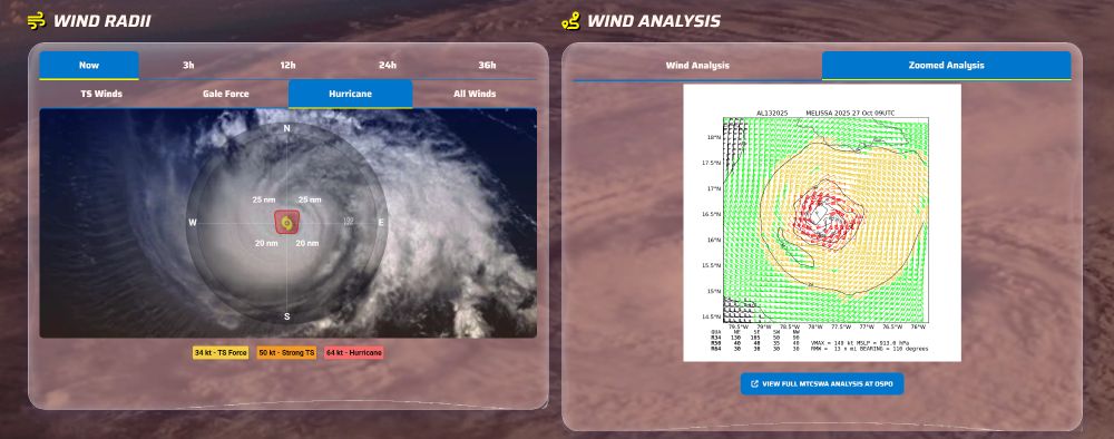
#Melissa's 64kt+ winds only extend out 20-25nm from the center but, holy cow, what a difference a few miles makes.
#hurricanemelissa
(From my Melissa page: www.nchurricane.com/active/?stor...)
#hurricanemelissa
(From my Melissa page: www.nchurricane.com/active/?stor...)
October 28, 2025 at 3:48 AM
#Melissa's 64kt+ winds only extend out 20-25nm from the center but, holy cow, what a difference a few miles makes.
#hurricanemelissa
(From my Melissa page: www.nchurricane.com/active/?stor...)
#hurricanemelissa
(From my Melissa page: www.nchurricane.com/active/?stor...)
#Melissa has started the forecast move to the NE. Looking at the #Jamaica radar, you can the see the eye go out of range (240nm) and then begin to creep back in.
Radar Link: (but the site has not been reliable over the past few hours): metservice.gov.jm/daily-foreca...
#hurricane #hurricanemelissa
Radar Link: (but the site has not been reliable over the past few hours): metservice.gov.jm/daily-foreca...
#hurricane #hurricanemelissa
October 28, 2025 at 2:59 AM
#Melissa has started the forecast move to the NE. Looking at the #Jamaica radar, you can the see the eye go out of range (240nm) and then begin to creep back in.
Radar Link: (but the site has not been reliable over the past few hours): metservice.gov.jm/daily-foreca...
#hurricane #hurricanemelissa
Radar Link: (but the site has not been reliable over the past few hours): metservice.gov.jm/daily-foreca...
#hurricane #hurricanemelissa