


Johnny K
@stormchaser4850.bsky.social
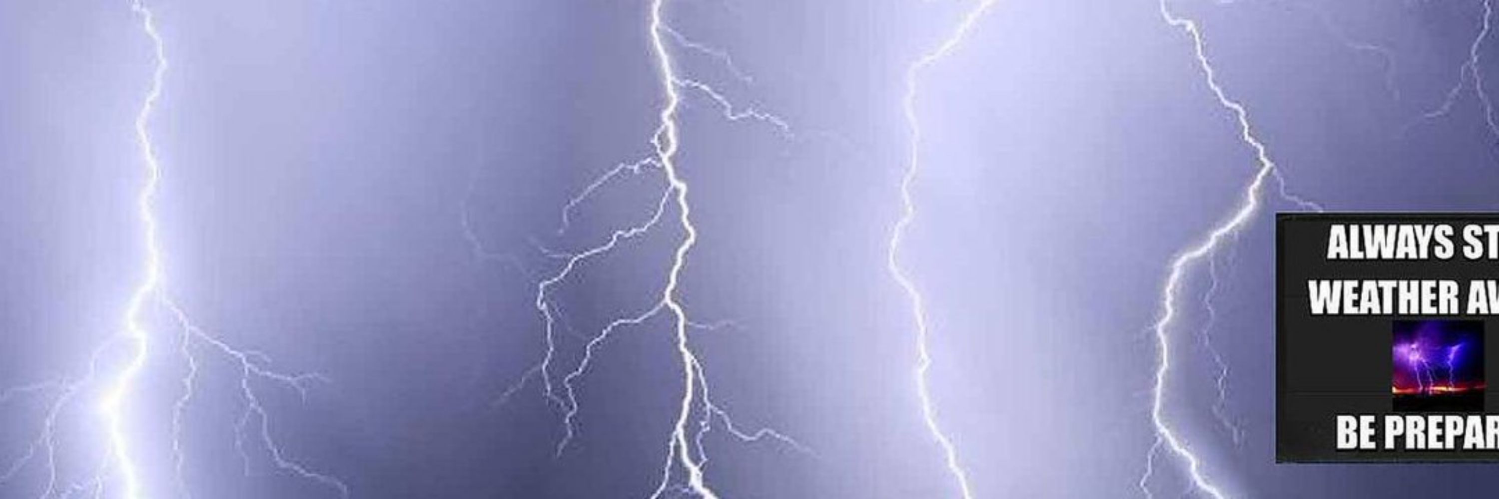
*Regardless of the method or source, you should ALWAYS STAY WEATHER AWARE as weather is ALWAYS changing*
(All weather, all the time)
TikTOK: https://www.tiktok.com/@alwaysstayweatheraware?lang=en
(All weather, all the time)
TikTOK: https://www.tiktok.com/@alwaysstayweatheraware?lang=en
Reposted by Johnny K

Fee-fi-fo-fum the Polar Vortex is about to come undone! 😳
That typically means wild weather/ big time cold to follow!
But wait, don’t head for the hills just yet. I assure you the sky won’t fall.
Seriously though, you’re bound to hear about this, and the science is fascinating, so let’s dig in… 1/
That typically means wild weather/ big time cold to follow!
But wait, don’t head for the hills just yet. I assure you the sky won’t fall.
Seriously though, you’re bound to hear about this, and the science is fascinating, so let’s dig in… 1/

November 18, 2025 at 12:13 AM
Fee-fi-fo-fum the Polar Vortex is about to come undone! 😳
That typically means wild weather/ big time cold to follow!
But wait, don’t head for the hills just yet. I assure you the sky won’t fall.
Seriously though, you’re bound to hear about this, and the science is fascinating, so let’s dig in… 1/
That typically means wild weather/ big time cold to follow!
But wait, don’t head for the hills just yet. I assure you the sky won’t fall.
Seriously though, you’re bound to hear about this, and the science is fascinating, so let’s dig in… 1/

Reposted by Johnny K

SFO received 1.14" of rainfall today breaking the previous daily record of 0.91" in 1996. https://x.com/NWSBayArea/status/1990581452157956317
November 18, 2025 at 12:44 AM
SFO received 1.14" of rainfall today breaking the previous daily record of 0.91" in 1996. https://x.com/NWSBayArea/status/1990581452157956317
Reposted by Johnny K

A good reminder that hazardous weather doesn't care what the calendar says. If the atmospheric conditions come together, severe weather and flooding can happen any time!
weather.gov/safety 🌪️
On this day in 2013, a High Risk was issued. 74 tornadoes occurred, including: 2 EF4s, 7 EF3s, and 24 EF2s.
weather.gov/safety 🌪️
On this day in 2013, a High Risk was issued. 74 tornadoes occurred, including: 2 EF4s, 7 EF3s, and 24 EF2s.


November 17, 2025 at 8:36 PM
A good reminder that hazardous weather doesn't care what the calendar says. If the atmospheric conditions come together, severe weather and flooding can happen any time!
weather.gov/safety 🌪️
On this day in 2013, a High Risk was issued. 74 tornadoes occurred, including: 2 EF4s, 7 EF3s, and 24 EF2s.
weather.gov/safety 🌪️
On this day in 2013, a High Risk was issued. 74 tornadoes occurred, including: 2 EF4s, 7 EF3s, and 24 EF2s.
Reposted by Johnny K
NOAA's #GOESEast 🛰️ is tracking the nation's weather on your Monday morning. Heavy rain will continue to bring the threat for flash flooding and landslides in southern California as another system drops locally heavy snow across parts of the Northeast. What's the forecast where you live? weather.gov
November 17, 2025 at 3:16 PM
NOAA's #GOESEast 🛰️ is tracking the nation's weather on your Monday morning. Heavy rain will continue to bring the threat for flash flooding and landslides in southern California as another system drops locally heavy snow across parts of the Northeast. What's the forecast where you live? weather.gov


November 17, 2025 at 12:20 PM
Reposted by Johnny K

4-day rain total at Santa Barbara, CA their heaviest in over 20 years (since Jan. 2005), and pushes them to a record Nov. tally dating to 1941.
Another inch or so today.
Some mountain locations in SBA County picked up over 10 inches of rain the past 72 hours.
Another inch or so today.
Some mountain locations in SBA County picked up over 10 inches of rain the past 72 hours.


November 17, 2025 at 11:08 AM
4-day rain total at Santa Barbara, CA their heaviest in over 20 years (since Jan. 2005), and pushes them to a record Nov. tally dating to 1941.
Another inch or so today.
Some mountain locations in SBA County picked up over 10 inches of rain the past 72 hours.
Another inch or so today.
Some mountain locations in SBA County picked up over 10 inches of rain the past 72 hours.
Reposted by Johnny K

November rain (🎸) vs. average: true, it is supposed to rain in November (one of the top 4 rain months) but we're running ahead of average and these numbers will certainly leap even more > average this week, thanks in large part to tonight's storm #CAwx 11/16/2025


November 17, 2025 at 2:37 AM
November rain (🎸) vs. average: true, it is supposed to rain in November (one of the top 4 rain months) but we're running ahead of average and these numbers will certainly leap even more > average this week, thanks in large part to tonight's storm #CAwx 11/16/2025
Reposted by Johnny K

"It's been a cold month. What global warming?" - Florida Man
November 16, 2025 at 6:47 PM
"It's been a cold month. What global warming?" - Florida Man
Reposted by Johnny K
60-day precipitation departure from normal. Most all states, with a few notable exceptions, are quite dry.

November 17, 2025 at 1:05 AM
60-day precipitation departure from normal. Most all states, with a few notable exceptions, are quite dry.
Live: #SaranacLake #NewYork ( #NYwx ): hotelsaranac.com/about/roofto...
#WinterStormWARNING through 7 pm EST Monday evening (November 17) for periods of moderate/heavy snow with total accumulations between 10 and 16 inches on northwesterly and westerly slopes along with winds of 35 mph #wx #wxsky
#WinterStormWARNING through 7 pm EST Monday evening (November 17) for periods of moderate/heavy snow with total accumulations between 10 and 16 inches on northwesterly and westerly slopes along with winds of 35 mph #wx #wxsky
November 17, 2025 at 1:07 AM
Live: #SaranacLake #NewYork ( #NYwx ): hotelsaranac.com/about/roofto...
#WinterStormWARNING through 7 pm EST Monday evening (November 17) for periods of moderate/heavy snow with total accumulations between 10 and 16 inches on northwesterly and westerly slopes along with winds of 35 mph #wx #wxsky
#WinterStormWARNING through 7 pm EST Monday evening (November 17) for periods of moderate/heavy snow with total accumulations between 10 and 16 inches on northwesterly and westerly slopes along with winds of 35 mph #wx #wxsky
Reposted by Johnny K
We've had beneficial rain the past few days, w/ more rain expected tonight into Monday. Be prepared for a messy commute Monday morning, plan for extra time if necessary. Below on the left is rainfall for the past 72hrs, on the right is expected ... https://x.com/NWSBayArea/status/1990199492495483274

November 16, 2025 at 11:41 PM
We've had beneficial rain the past few days, w/ more rain expected tonight into Monday. Be prepared for a messy commute Monday morning, plan for extra time if necessary. Below on the left is rainfall for the past 72hrs, on the right is expected ... https://x.com/NWSBayArea/status/1990199492495483274
Reposted by Johnny K
Plan on a stormy finish to the weekend 🚨 increasing wind and rain late evening and overnight as a fast moving but intense cold front moves through. We will likely see some localized runoff issues overnight w/ lingering impacts possible into the Monday morning commute. 11/16/2025
November 16, 2025 at 11:43 PM
Plan on a stormy finish to the weekend 🚨 increasing wind and rain late evening and overnight as a fast moving but intense cold front moves through. We will likely see some localized runoff issues overnight w/ lingering impacts possible into the Monday morning commute. 11/16/2025
( #NWSWPC): ⚠️ Here's a look at the precipitation forecast for the next 7 DAYS.
A series of systems will keep conditions unsettled across the West, while a more substantial system brings a threat of heavy showers and thunderstorms to the south-central #USwx towards the end of the week. ⛈️ #wx #wxsky
A series of systems will keep conditions unsettled across the West, while a more substantial system brings a threat of heavy showers and thunderstorms to the south-central #USwx towards the end of the week. ⛈️ #wx #wxsky

November 17, 2025 at 12:17 AM
( #NWSWPC): ⚠️ Here's a look at the precipitation forecast for the next 7 DAYS.
A series of systems will keep conditions unsettled across the West, while a more substantial system brings a threat of heavy showers and thunderstorms to the south-central #USwx towards the end of the week. ⛈️ #wx #wxsky
A series of systems will keep conditions unsettled across the West, while a more substantial system brings a threat of heavy showers and thunderstorms to the south-central #USwx towards the end of the week. ⛈️ #wx #wxsky

Reposted by Johnny K
A strong cold front will bring widespread moderate rain, gusty winds, potential for thunderstorms, and nuisance flooding to the Bay Area and Central Coast Sunday night into Monday morning. Remember to slow down and avoid flooded roadways on the ... https://x.com/NWSBayArea/status/1990020844479795466

November 16, 2025 at 11:38 AM
A strong cold front will bring widespread moderate rain, gusty winds, potential for thunderstorms, and nuisance flooding to the Bay Area and Central Coast Sunday night into Monday morning. Remember to slow down and avoid flooded roadways on the ... https://x.com/NWSBayArea/status/1990020844479795466
Reposted by Johnny K

Temperatures have warmed across the contiguous United States over the last five decades or so during the months of December through February (a rapidly warming season)...
Check out @climatecentral.org's winter package for more information and graphics: www.climatecentral.org/climate-matt... ❄️🥵
Check out @climatecentral.org's winter package for more information and graphics: www.climatecentral.org/climate-matt... ❄️🥵

November 15, 2025 at 5:41 PM
Temperatures have warmed across the contiguous United States over the last five decades or so during the months of December through February (a rapidly warming season)...
Check out @climatecentral.org's winter package for more information and graphics: www.climatecentral.org/climate-matt... ❄️🥵
Check out @climatecentral.org's winter package for more information and graphics: www.climatecentral.org/climate-matt... ❄️🥵

November 16, 2025 at 12:21 PM
Reposted by Johnny K

That #LARain is really coming down this morning. Flash Flood Warnings for all of Los Angeles, with one "Considerable" west of town. Various reports of flooded roads, rocks & trees down.
November 15, 2025 at 4:43 PM
That #LARain is really coming down this morning. Flash Flood Warnings for all of Los Angeles, with one "Considerable" west of town. Various reports of flooded roads, rocks & trees down.


November 15, 2025 at 12:21 PM
Reposted by Johnny K
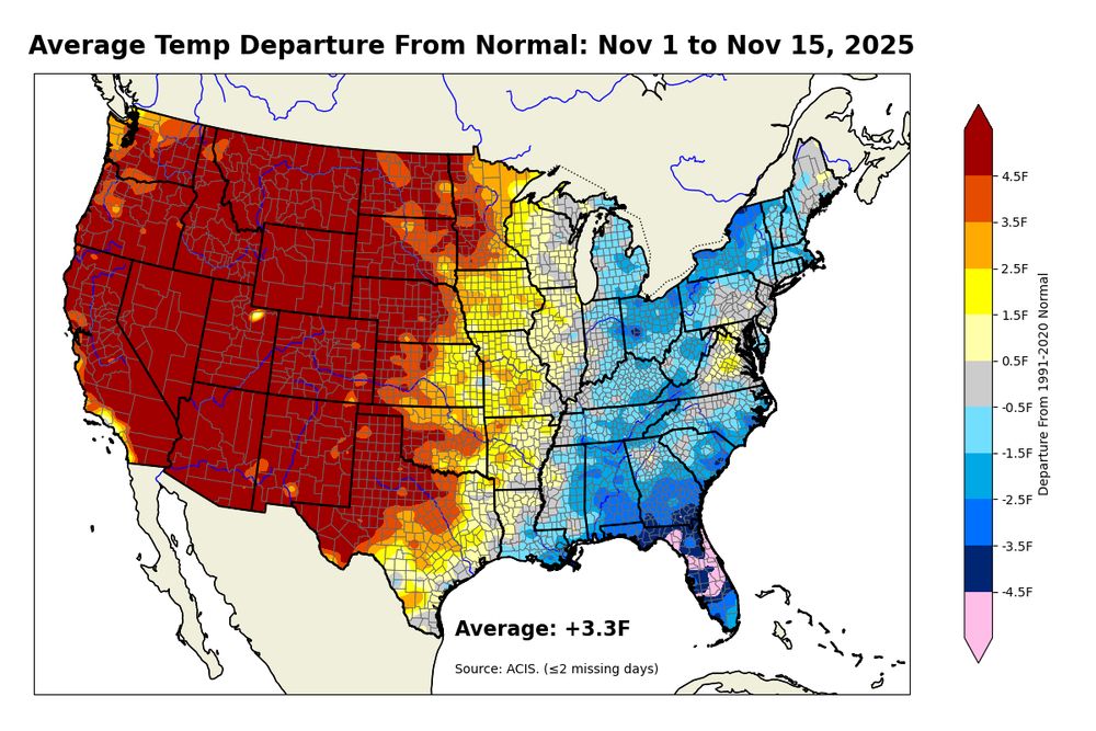
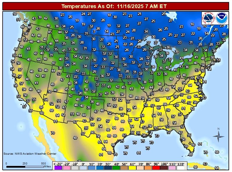
You thought our Deep South record cold was impressive? Take a look at this record heat! 100 plus record highs today across the Nation’s middle. Temps in some of the Northern Plains besting Florida!
Pretty darn comfortable for November.
Pretty darn comfortable for November.

November 14, 2025 at 9:29 PM
You thought our Deep South record cold was impressive? Take a look at this record heat! 100 plus record highs today across the Nation’s middle. Temps in some of the Northern Plains besting Florida!
Pretty darn comfortable for November.
Pretty darn comfortable for November.

( #NWSCPC): A SIGNIFICANT pattern change is becoming increasingly likely across much of the country during late November and early December www.cpc.ncep.noaa.gov/cpc_key_mess...
#USwx #wx #wxsky
#USwx #wx #wxsky

November 14, 2025 at 9:40 PM
( #NWSCPC): A SIGNIFICANT pattern change is becoming increasingly likely across much of the country during late November and early December www.cpc.ncep.noaa.gov/cpc_key_mess...
#USwx #wx #wxsky
#USwx #wx #wxsky
Reposted by Johnny K
A surge of unseasonably warm air is resulting in near-record to record-breaking high temperatures across a broad region of the Central and Southern Plains.
The combination of this unusual warmth, low relative humidity, and the strong, gusty winds will create favorable fire weather conditions.
The combination of this unusual warmth, low relative humidity, and the strong, gusty winds will create favorable fire weather conditions.

November 14, 2025 at 6:45 PM
A surge of unseasonably warm air is resulting in near-record to record-breaking high temperatures across a broad region of the Central and Southern Plains.
The combination of this unusual warmth, low relative humidity, and the strong, gusty winds will create favorable fire weather conditions.
The combination of this unusual warmth, low relative humidity, and the strong, gusty winds will create favorable fire weather conditions.