Johnny K
banner
stormchaser4850.bsky.social
Johnny K
@stormchaser4850.bsky.social
*Regardless of the method or source, you should ALWAYS STAY WEATHER AWARE as weather is ALWAYS changing*

(All weather, all the time)

TikTOK: https://www.tiktok.com/@alwaysstayweatheraware?lang=en
( #NOAASatellites): The LONG #PolarNight has begun in the United States' northernmost city— #Utqiaġvik, #Alaska!

Yesterday, @noaa.gov's #GOESWest ( #GOES18) 🛰️ captured the LAST #sunset of the year in Utqiaġvik. The sun will rise above the horizon again in about 64 days on January 22, 2026. #wxsky
November 19, 2025 at 10:23 PM
( #NWSBirmingham): BREAKING: An additional EF-2 #tornado has been documented from the HISTORIC TORNADO OUTBREAK of April 15, 2011. #Alabama #ALwx #wx #wxsky

Additional details can be found here and in the attached images: www.weather.gov/bmx/event_04...
November 19, 2025 at 9:29 PM
7 am EST/6 am CST Wednesday morning (November 19) #USwx #TEMPERATURES #wx #wxsky
November 19, 2025 at 12:22 PM
( #NWSWPC): Locally heavy rainfall will bring chances for Flash #FLOODING starting tomorrow (November 19) mostly in #Texas ( #TXwx ) and then training across Texas northeastward toward the Ozarks on Thursday (November 20) #wx #wxsky
November 18, 2025 at 10:08 PM
7 am EST/6 am CST Tuesday morning (November 18) #USwx #TEMPERATURES #wx #wxsky
November 18, 2025 at 12:19 PM
( #NWSVegas): Heads up! Another round of heavy rain is on the way which could lead to localized #FLOODING. Be mindful of #FLOOD sensitive basins, washes, and be prepared to seek higher ground if you encounter FLOOD waters. #LasVegas #CAwx #NVwx #AZwx #wx #wxsky
November 18, 2025 at 1:23 AM
7 am EST/6 am CST Monday morning (November 17) #USwx #TEMPERATURES #wx #wxsky
November 17, 2025 at 12:20 PM
Live: #SaranacLake #NewYork ( #NYwx ): hotelsaranac.com/about/roofto...

#WinterStormWARNING through 7 pm EST Monday evening (November 17) for periods of moderate/heavy snow with total accumulations between 10 and 16 inches on northwesterly and westerly slopes along with winds of 35 mph #wx #wxsky
November 17, 2025 at 1:07 AM
( #NWSWPC): ⚠️ Here's a look at the precipitation forecast for the next 7 DAYS.

A series of systems will keep conditions unsettled across the West, while a more substantial system brings a threat of heavy showers and thunderstorms to the south-central #USwx towards the end of the week. ⛈️ #wx #wxsky
November 17, 2025 at 12:17 AM
( #NWSVegas): Yesterday (November 15) was uncharacteristically WET across the region! Here's a look at the rainfall totals at the major regional observation points. #CAwx #NVwx #AZwx #LasVegas #VegasWeather #wx #wxsky
November 16, 2025 at 6:47 PM
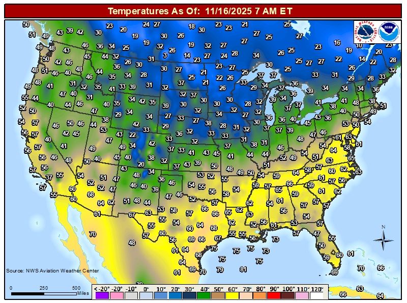
7 am EST/6 am CST Sunday morning (November 16) #USwx #TEMPERATURES #wx #wxsky
November 16, 2025 at 12:21 PM
( #NWSReno): Look at that spin 🤩 This system has been a menace to deal with from a forecast standpoint. It's not winter yet folks; it's definitely still transition season. #NVwx #CAwx #wx #wxsky
November 16, 2025 at 12:02 AM
7 am EST/6 am CST Saturday morning (November 15) #USwx #TEMPERATURES #wx #wxsky
November 15, 2025 at 12:21 PM
( #NWSGSP): The WARMER air is here to stay before the #Thanksgiving holiday.

#SCwx #NCwx #GAwx #USwx #wx #wxsky
November 14, 2025 at 10:54 PM
( #NWSCPC): A SIGNIFICANT pattern change is becoming increasingly likely across much of the country during late November and early December www.cpc.ncep.noaa.gov/cpc_key_mess...

#USwx #wx #wxsky
November 14, 2025 at 9:40 PM
7 am EST/6 am CST Friday morning (November 14) #USwx #TEMPERATURES #wx #wxsky
November 14, 2025 at 12:20 PM
( #NWSSWPC): An X4.0 flare occurred at 14/0830 UTC from Region 4274. #USwx #wx #wxsky
November 14, 2025 at 12:05 PM
( #NWSWPC): 🌧️An ATMOSPHERIC RIVER will continue to impact #California through late Saturday/early Sunday. Heavy rain will shift from Central #CAwx today to Southern CA on Friday. Heavy precipitation may lead to scattered instances of flash #FLOODING, especially near burn scars and steep terrain. #wx
November 13, 2025 at 7:19 PM
( #NWSCPC): La Niña is favored to continue into the Northern Hemisphere #winter, with a transition to ENSO-neutral most likely in January-March 2026 (61% chance). A #LaNina Advisory remains in effect. #USwx #wx #wxsky #ENSO www.cpc.ncep.noaa.gov/products/ana...
November 13, 2025 at 2:11 PM
7 am EST/6 am CST Thursday morning (November 13) #USwx #TEMPERATURES #wx #wxsky
November 13, 2025 at 12:22 PM
( #NWSEastern): Well we've had quite a number of #USwx locations that saw a sighting of the 4 letter "S" word the last few days. With that, here is a look at where #snowfall totals stand this season so far in the East. Yes, #Boston has had less #snow than many areas in #NorthCarolina #wx #wxsky
November 13, 2025 at 6:10 AM
( #NWS_BaltWash): While last evening featured some clouds, tonight has provided a clearer view of the #NorthernLights. All photos from our office near Dulles Airport last night and tonight. #DCwx #wx #wxsky

For the latest space weather forecast: spaceweather.gov
November 13, 2025 at 3:17 AM
( #NWSSWPC): Here is another video update from us here at #SWPC as the FINAL CME has arrived. Hopefully these help, please let us know if you find them useful and we'll see what we can do for future events. Stay space weather aware at www.spaceweather.gov

#NorthernLights #Aurora #USwx #wx #wxsky
November 13, 2025 at 12:51 AM
7 am EST/6 am CST Wednesday morning (November 12) #USwx #TEMPERATURES #wx #wxsky
November 12, 2025 at 12:21 PM
( #NWSSeattle): #Aurora Borealis as seen from the office roof this evening over Lake Washington! High clouds will continue to increase tonight, but any breaks in the clouds will allow for the #NorthernLights to be visible. #WAwx #wx #wxsky
November 12, 2025 at 12:12 PM