


Lars Lowinski
@larswx.bsky.social
RMetS Chartered Meteorologist, photographer, occasional storm chaser.
Interested in severe weather, natural hazards and risk communication.
Opinions are my own.
My photography: larslowinski.com
Interested in severe weather, natural hazards and risk communication.
Opinions are my own.
My photography: larslowinski.com
Reposted by Lars Lowinski

Grazalema, Spain, received over 2,000 mm (78 inches) of rain in just the last 20 days.
Over a year’s worth of rain — and it’s only early February. This is hydrologically absurd.
Over a year’s worth of rain — and it’s only early February. This is hydrologically absurd.

February 9, 2026 at 4:11 PM
Grazalema, Spain, received over 2,000 mm (78 inches) of rain in just the last 20 days.
Over a year’s worth of rain — and it’s only early February. This is hydrologically absurd.
Over a year’s worth of rain — and it’s only early February. This is hydrologically absurd.
Reposted by Lars Lowinski

Bizarre scenes in eastern Germany after days of mixed precipitation. A layer of black ice and frozen snow several centimeters thick is causing chaotic conditions on the roads. Images via WarnWetter-App @dwdderwetterdienst.bsky.social #Winter #Weather #Snow #Ice


February 6, 2026 at 8:25 AM
Bizarre scenes in eastern Germany after days of mixed precipitation. A layer of black ice and frozen snow several centimeters thick is causing chaotic conditions on the roads. Images via WarnWetter-App @dwdderwetterdienst.bsky.social #Winter #Weather #Snow #Ice
Reposted by Lars Lowinski

New all-time minimum sea level in the Baltic Sea!
The Föglö tide gauge measured just -71.6 cm below the mean level which is the lowest value ever recorded there. Records have been kept over 100 years, since 1924 (!).
The sea level is still decreasing. (1/3)
The Föglö tide gauge measured just -71.6 cm below the mean level which is the lowest value ever recorded there. Records have been kept over 100 years, since 1924 (!).
The sea level is still decreasing. (1/3)

February 4, 2026 at 10:12 AM
New all-time minimum sea level in the Baltic Sea!
The Föglö tide gauge measured just -71.6 cm below the mean level which is the lowest value ever recorded there. Records have been kept over 100 years, since 1924 (!).
The sea level is still decreasing. (1/3)
The Föglö tide gauge measured just -71.6 cm below the mean level which is the lowest value ever recorded there. Records have been kept over 100 years, since 1924 (!).
The sea level is still decreasing. (1/3)
A photo from a recent colourful evening across the plains of western Victoria, #Australia, near Horsham, as a cool change moved through, accompanied by some high-based convection and virga #stormhour

February 2, 2026 at 1:21 PM
A photo from a recent colourful evening across the plains of western Victoria, #Australia, near Horsham, as a cool change moved through, accompanied by some high-based convection and virga #stormhour
Massive smoke plumes from a large bushfire near Gellibrand, Victoria, yesterday which prompted emergency warnings in the area. The fire even produced a towering pyrocumulus and pileus cloud as the hot updraft pushed through stable layers in the mid-levels. #fireweather #stormhour


January 25, 2026 at 10:36 AM
Massive smoke plumes from a large bushfire near Gellibrand, Victoria, yesterday which prompted emergency warnings in the area. The fire even produced a towering pyrocumulus and pileus cloud as the hot updraft pushed through stable layers in the mid-levels. #fireweather #stormhour
A spell of extreme heat and fire danger is on the cards across SE Australia.
We’ve been through 48C heat in the W Pilbara on 5 January, wasn’t fun 😅
Sth I noticed here: the visibility of information on natural hazards on many platforms, whether it’s cyclones, floods or fires. #weatherawareness
We’ve been through 48C heat in the W Pilbara on 5 January, wasn’t fun 😅
Sth I noticed here: the visibility of information on natural hazards on many platforms, whether it’s cyclones, floods or fires. #weatherawareness


January 23, 2026 at 7:24 AM
A spell of extreme heat and fire danger is on the cards across SE Australia.
We’ve been through 48C heat in the W Pilbara on 5 January, wasn’t fun 😅
Sth I noticed here: the visibility of information on natural hazards on many platforms, whether it’s cyclones, floods or fires. #weatherawareness
We’ve been through 48C heat in the W Pilbara on 5 January, wasn’t fun 😅
Sth I noticed here: the visibility of information on natural hazards on many platforms, whether it’s cyclones, floods or fires. #weatherawareness
Reposted by Lars Lowinski

Landed in London. There was a CRAZY aurora outside on the flight over, I've never seen anything like it! Absolutely surreal...


January 20, 2026 at 12:09 PM
Landed in London. There was a CRAZY aurora outside on the flight over, I've never seen anything like it! Absolutely surreal...
Reposted by Lars Lowinski

As the climate data for 2025 continues to be released, it's time to update various data visualisations.
First - the global climate stripes for 1850-2025. A third darkest red stripe is added.
The last 11 years have been the warmest 11 years on record. A sequence that is unlikely to be broken soon.
First - the global climate stripes for 1850-2025. A third darkest red stripe is added.
The last 11 years have been the warmest 11 years on record. A sequence that is unlikely to be broken soon.


January 14, 2026 at 11:02 AM
As the climate data for 2025 continues to be released, it's time to update various data visualisations.
First - the global climate stripes for 1850-2025. A third darkest red stripe is added.
The last 11 years have been the warmest 11 years on record. A sequence that is unlikely to be broken soon.
First - the global climate stripes for 1850-2025. A third darkest red stripe is added.
The last 11 years have been the warmest 11 years on record. A sequence that is unlikely to be broken soon.
Reposted by Lars Lowinski

Is damaging hail getting worse? An ESSL-led study published in Nature Geoscience finds that very large hail is modelled to occur most frequently in South America, the United States, and South Africa, but Europe shows the strongest increase in very large hail frequency. doi.org/10.1038/s415...

January 12, 2026 at 1:30 PM
Is damaging hail getting worse? An ESSL-led study published in Nature Geoscience finds that very large hail is modelled to occur most frequently in South America, the United States, and South Africa, but Europe shows the strongest increase in very large hail frequency. doi.org/10.1038/s415...
Dust devils and a possible landspout in brutal 47C heat SW of Karratha, Western Australia, yesterday afternoon. #photography #stormhour


January 6, 2026 at 8:20 AM
Dust devils and a possible landspout in brutal 47C heat SW of Karratha, Western Australia, yesterday afternoon. #photography #stormhour
Little Lagoon Creek and Beach, Shark Bay, Australia #PhotoHour

January 1, 2026 at 2:05 PM
Little Lagoon Creek and Beach, Shark Bay, Australia #PhotoHour
#Uluru, Northern Territory, with its famous evening glow a few days ago. There was quite a bit of high-based convective cloud that afternoon in 38C heat, so chances for a decent sunset didn’t seem that high at first.
But skies cleared enough just in time. #stormhour
But skies cleared enough just in time. #stormhour

December 19, 2025 at 7:06 AM
#Uluru, Northern Territory, with its famous evening glow a few days ago. There was quite a bit of high-based convective cloud that afternoon in 38C heat, so chances for a decent sunset didn’t seem that high at first.
But skies cleared enough just in time. #stormhour
But skies cleared enough just in time. #stormhour
Reposted by Lars Lowinski

It’s simply not possible to overstate how important NCAR is to US and world science. We need to fight this with everything we’ve got.

Exclusive: The Trump administration is moving to dismantle the National Center for Atmospheric Research in Colorado, according to a senior White House official, taking aim at one of the world's leading climate research labs.

Trump moves to dismantle major US climate research center in Colorado
The Trump administration is breaking up the National Center for Atmospheric Research, taking aim at one of the world's leading climate research labs.
bit.ly
December 17, 2025 at 12:15 PM
It’s simply not possible to overstate how important NCAR is to US and world science. We need to fight this with everything we’ve got.
Colourful and hazy sunset earlier near Bowen, QLD, Australia after a hot and fairly windy Tuesday. There were some smoke plumes in the air from nearby (small) bushfires. #stormhour

December 2, 2025 at 10:54 AM
Colourful and hazy sunset earlier near Bowen, QLD, Australia after a hot and fairly windy Tuesday. There were some smoke plumes in the air from nearby (small) bushfires. #stormhour
Beautiful halo with a nicely positioned cloud above Airlie Beach, QLD, Australia earlier today. #stormhour #atmosphericoptics

November 30, 2025 at 10:20 AM
Beautiful halo with a nicely positioned cloud above Airlie Beach, QLD, Australia earlier today. #stormhour #atmosphericoptics

Reposted by Lars Lowinski

Expert comment about more destructive tropical cyclones as the world warms:
theconversation.com/hurricane-me...
theconversation.com/hurricane-me...

Hurricane Melissa is a warning – why violent storms are increasingly catching the world off guard
In a single day, Melissa exploded from a moderate storm into a major hurricane with 170mph winds.
theconversation.com
October 30, 2025 at 7:51 AM
Expert comment about more destructive tropical cyclones as the world warms:
theconversation.com/hurricane-me...
theconversation.com/hurricane-me...
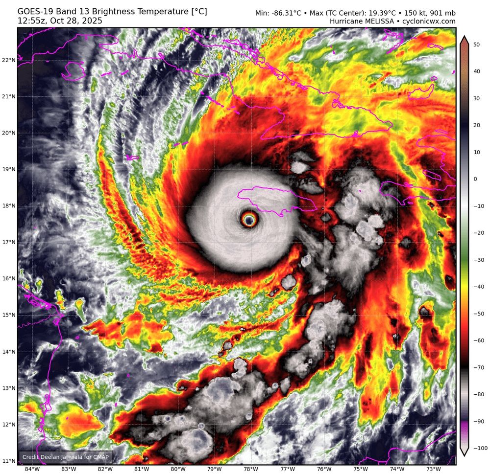
This is amazing footage.

This is footage taken earlier today of the eye of Hurricane Melissa.
The entire view is remarkable, of the core of one of the strongest Atlantic basic hurricanes in recorded history, and a catastrophic hit to Jamaica and the central Caribbean.
The entire view is remarkable, of the core of one of the strongest Atlantic basic hurricanes in recorded history, and a catastrophic hit to Jamaica and the central Caribbean.
October 29, 2025 at 12:51 PM
This is amazing footage.
Reposted by Lars Lowinski

Wow. This is easily the most ridiculous dropsonde I’ve ever seen.
188 knot mean winds in the low-levels with gusts over 250 mph
Absolutely scary and historic hurricane headed into SW Jamaica this morning
188 knot mean winds in the low-levels with gusts over 250 mph
Absolutely scary and historic hurricane headed into SW Jamaica this morning
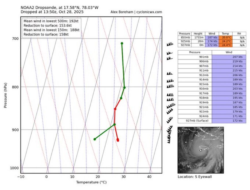
October 28, 2025 at 2:21 PM
Wow. This is easily the most ridiculous dropsonde I’ve ever seen.
188 knot mean winds in the low-levels with gusts over 250 mph
Absolutely scary and historic hurricane headed into SW Jamaica this morning
188 knot mean winds in the low-levels with gusts over 250 mph
Absolutely scary and historic hurricane headed into SW Jamaica this morning
Reposted by Lars Lowinski

With a central pressure down to 896mb as of 9am EDT, #Melissa has joined the elite sub-900mb group of Atlantic hurricanes... it is now one of just seven:
Wilma 2005: 882mb
Gilbert 1988: 888mb
Labor Day 1935: 892mb
Rita 2005: 895mb
Milton 2024: 895mb
Melissa 2025: 896mb
Allen 1980: 899mb
Wilma 2005: 882mb
Gilbert 1988: 888mb
Labor Day 1935: 892mb
Rita 2005: 895mb
Milton 2024: 895mb
Melissa 2025: 896mb
Allen 1980: 899mb
October 28, 2025 at 1:20 PM
With a central pressure down to 896mb as of 9am EDT, #Melissa has joined the elite sub-900mb group of Atlantic hurricanes... it is now one of just seven:
Wilma 2005: 882mb
Gilbert 1988: 888mb
Labor Day 1935: 892mb
Rita 2005: 895mb
Milton 2024: 895mb
Melissa 2025: 896mb
Allen 1980: 899mb
Wilma 2005: 882mb
Gilbert 1988: 888mb
Labor Day 1935: 892mb
Rita 2005: 895mb
Milton 2024: 895mb
Melissa 2025: 896mb
Allen 1980: 899mb
Reposted by Lars Lowinski

A true catastrophe is likely to unfold in Jamaica, as multiple days of rain followed by a direct hit from a top-end hurricane push the limits of what the country has seen historically. Details on the forecast, which aren’t much changed today below and at theeyewall.com.

Melissa explodes into a powerful hurricane, and it is going to deliver catastrophic impacts to Jamaica
Flooding, surge, and wind all look truly awful for Jamaica.
open.substack.com
October 26, 2025 at 5:59 PM
A true catastrophe is likely to unfold in Jamaica, as multiple days of rain followed by a direct hit from a top-end hurricane push the limits of what the country has seen historically. Details on the forecast, which aren’t much changed today below and at theeyewall.com.
Reposted by Lars Lowinski

NHC now explicitly calls for Melissa to reach category 5 intensity before striking Jamaica.
The addition of Google DeepMind’s FNV3 ensemble this year bolstered forecast confidence in extreme intensification — it’s doubtful the NHC forecast would’ve been this aggressive without FNV3.
The addition of Google DeepMind’s FNV3 ensemble this year bolstered forecast confidence in extreme intensification — it’s doubtful the NHC forecast would’ve been this aggressive without FNV3.


October 25, 2025 at 9:08 PM
NHC now explicitly calls for Melissa to reach category 5 intensity before striking Jamaica.
The addition of Google DeepMind’s FNV3 ensemble this year bolstered forecast confidence in extreme intensification — it’s doubtful the NHC forecast would’ve been this aggressive without FNV3.
The addition of Google DeepMind’s FNV3 ensemble this year bolstered forecast confidence in extreme intensification — it’s doubtful the NHC forecast would’ve been this aggressive without FNV3.
This could become a catastrophic flood and wind event for Jamaica in particular.

1:52 PM EDT, 10/25: #HurricaneMelissa, a Category 1 hurricane with 75 mph winds, is SW of #Haiti. It is expected to rapidly intensify and reach high end #Category4 (possibly #Category5) #Monday as it moves towards #Jamaica, with heavy #rainfall (up to 30”/750mm) & #flooding forecast.


October 25, 2025 at 6:58 PM
This could become a catastrophic flood and wind event for Jamaica in particular.
Reposted by Lars Lowinski

Tropical Storm #Melissa has not yet strengthened. But this actually bad news, since a weaker storm is more likely to linger in the Caribbean and become a major hurricane, as @bhensonweather.bsky.social and I explain:
yaleclimateconnections.org/2025/10/trop...
yaleclimateconnections.org/2025/10/trop...

Tropical Storm Melissa not yet strengthening, but still expected to become a dangerous Caribbean hurricane » Yale Climate Connections
The track forecast is more uncertain than usual, but Melissa is likely to bring colossal rains and life-threatening flooding to multiple islands in the Caribbean.
yaleclimateconnections.org
October 22, 2025 at 4:29 PM
Tropical Storm #Melissa has not yet strengthened. But this actually bad news, since a weaker storm is more likely to linger in the Caribbean and become a major hurricane, as @bhensonweather.bsky.social and I explain:
yaleclimateconnections.org/2025/10/trop...
yaleclimateconnections.org/2025/10/trop...
Reposted by Lars Lowinski

Tornadoes in France today. At least one death and 9 injuries, unfortunate but somewhat inevitable when a significant tornado (seems to be at least an IF2 to me) strikes such a populated area. Europe has a severe lack of tornado awareness and when a violent one will strike a highly populated area...

Oh, that's interesting ! So far, we have two tornadoes for today, but not on those locations !
The first one in Ermont/Eaubonne : www.facebook.com/1284867853/v...
The first one in Ermont/Eaubonne : www.facebook.com/1284867853/v...

Isabelle Lesot Yvart on Reels
www.facebook.com
October 20, 2025 at 7:15 PM
Tornadoes in France today. At least one death and 9 injuries, unfortunate but somewhat inevitable when a significant tornado (seems to be at least an IF2 to me) strikes such a populated area. Europe has a severe lack of tornado awareness and when a violent one will strike a highly populated area...