


Lars Lowinski
@larswx.bsky.social
RMetS Chartered Meteorologist, photographer, occasional storm chaser.
Interested in severe weather, natural hazards and risk communication.
Opinions are my own.
My photography: larslowinski.com
Interested in severe weather, natural hazards and risk communication.
Opinions are my own.
My photography: larslowinski.com
Widespread power cuts affecting western and central Scotland just now as a result of damaging winds from #StormAmy (source: ssen.co.uk)

October 3, 2025 at 9:02 PM
Widespread power cuts affecting western and central Scotland just now as a result of damaging winds from #StormAmy (source: ssen.co.uk)
#StormAmy probably being named very soon as models are in better agreement this morning. It could be a record-breaker in terms of low pressure for the time of year as well.
W + N Scotland in particular is likely to see some intense winds with this one.
W + N Scotland in particular is likely to see some intense winds with this one.


October 1, 2025 at 9:12 AM
#StormAmy probably being named very soon as models are in better agreement this morning. It could be a record-breaker in terms of low pressure for the time of year as well.
W + N Scotland in particular is likely to see some intense winds with this one.
W + N Scotland in particular is likely to see some intense winds with this one.
While the Azores have seen some tropical storms and a few hurricanes in the past, #Gabrielle will be at the upper end of the climatological range in terms of intensity. People on the central islands in particular should take this storm seriously and prepare for it


September 25, 2025 at 10:27 AM
While the Azores have seen some tropical storms and a few hurricanes in the past, #Gabrielle will be at the upper end of the climatological range in terms of intensity. People on the central islands in particular should take this storm seriously and prepare for it
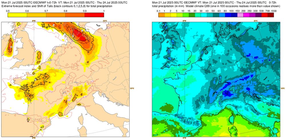
This one will happen very close to home...heavy (locally thundery) rain in far W Germany and surrounding areas. A few locations could see up to 100 mm in under 24 hours, enough to cause some flooding issues despite rather dry antecedent conditions. #weather


September 8, 2025 at 11:16 AM
This one will happen very close to home...heavy (locally thundery) rain in far W Germany and surrounding areas. A few locations could see up to 100 mm in under 24 hours, enough to cause some flooding issues despite rather dry antecedent conditions. #weather
#lunareclipse2025 as seen in the Siebengebirge hills near Bonn earlier today.


September 7, 2025 at 9:33 PM
#lunareclipse2025 as seen in the Siebengebirge hills near Bonn earlier today.
A peaceful scene near the High Fens in eastern Belgium on a recent chilly August morning, with a whiff of autumn already in the air.
#landscapephotography
#landscapephotography

August 25, 2025 at 12:45 PM
A peaceful scene near the High Fens in eastern Belgium on a recent chilly August morning, with a whiff of autumn already in the air.
#landscapephotography
#landscapephotography

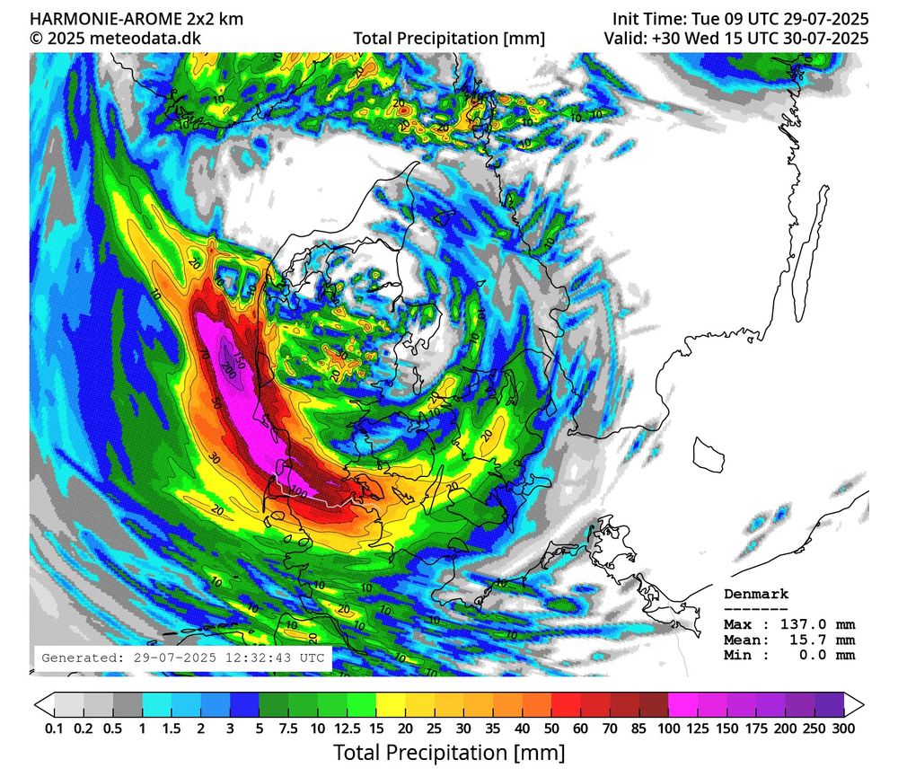
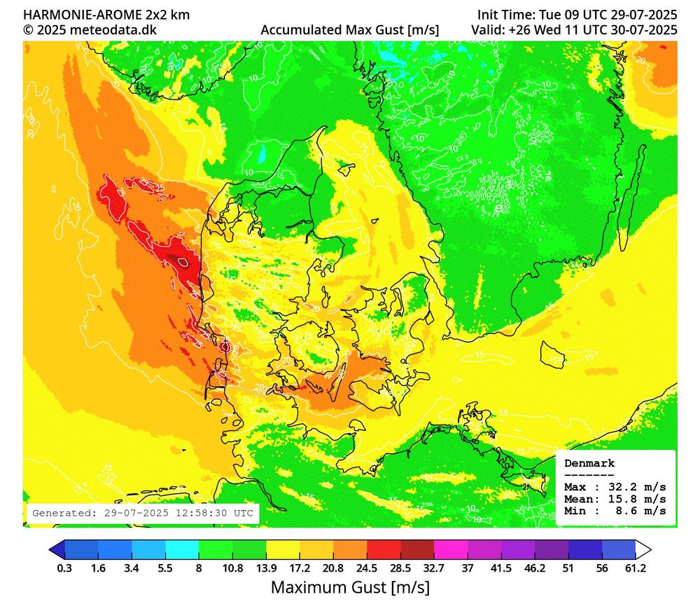
It will feel like a tropical storm for people living / holidaying on the W Danish coasts or in far N Germany in terms of rain and wind (only with lower temperatures and no, it is NOT a tropical system). High-res models indicate very heavy rain through late WED and local gusts between 80 and 100km/h
July 29, 2025 at 4:14 PM
It will feel like a tropical storm for people living / holidaying on the W Danish coasts or in far N Germany in terms of rain and wind (only with lower temperatures and no, it is NOT a tropical system). High-res models indicate very heavy rain through late WED and local gusts between 80 and 100km/h
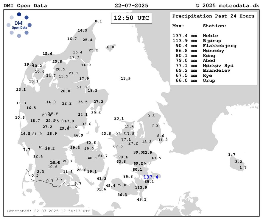
A quite remarkable rainfall event is unfolding in south and east Denmark. Some stations have seen over 100mm in the past 24 hours, with Neble in the far SE recording 136.7mm so far.
The Danish all-time 24h record is 168.9mm recorded in July 1931.
There are increasing reports of flooding.
The Danish all-time 24h record is 168.9mm recorded in July 1931.
There are increasing reports of flooding.
July 22, 2025 at 12:59 PM
A quite remarkable rainfall event is unfolding in south and east Denmark. Some stations have seen over 100mm in the past 24 hours, with Neble in the far SE recording 136.7mm so far.
The Danish all-time 24h record is 168.9mm recorded in July 1931.
There are increasing reports of flooding.
The Danish all-time 24h record is 168.9mm recorded in July 1931.
There are increasing reports of flooding.
Busy days at the ESSL Expert Testbed in Wiener Neustadt. We discussed the previous day’s extensive severe weather in France, followed by an in-depth look at the risk across Austria and surrounding areas today. @essl-ecss.bsky.social


June 26, 2025 at 12:54 PM
Busy days at the ESSL Expert Testbed in Wiener Neustadt. We discussed the previous day’s extensive severe weather in France, followed by an in-depth look at the risk across Austria and surrounding areas today. @essl-ecss.bsky.social
Brilliant display of asperitas clouds across the Rhine valley near Bonn at around 5am this morning, as rain and thunderstorms approached from the SW atop a slightly cooler and stable boundary layer with NW winds. #StormHour @weatherandradar.bsky.social


June 15, 2025 at 11:57 AM
Brilliant display of asperitas clouds across the Rhine valley near Bonn at around 5am this morning, as rain and thunderstorms approached from the SW atop a slightly cooler and stable boundary layer with NW winds. #StormHour @weatherandradar.bsky.social
Severe risk later today and into Saturday across parts of W Europe as moderately strong SW upper flow overlaps with areas of seasonally high instability.
Parts of France, SE England & Belgium are likely to see severe storms through early Saturday, with large hail and damaging winds in places
Parts of France, SE England & Belgium are likely to see severe storms through early Saturday, with large hail and damaging winds in places


June 13, 2025 at 11:56 AM
Severe risk later today and into Saturday across parts of W Europe as moderately strong SW upper flow overlaps with areas of seasonally high instability.
Parts of France, SE England & Belgium are likely to see severe storms through early Saturday, with large hail and damaging winds in places
Parts of France, SE England & Belgium are likely to see severe storms through early Saturday, with large hail and damaging winds in places
View to the west from a webcam in the NW of Munich as a supercell storm approaches the city. Hail up to 3cm was reported in some nearby locations. #weather

June 4, 2025 at 6:12 PM
View to the west from a webcam in the NW of Munich as a supercell storm approaches the city. Hail up to 3cm was reported in some nearby locations. #weather
A Mesoscale Discussion has been issued by estofex.org, highlighting the increasing risk of rapid severe thunderstorm development late this afternoon across SE Germany. The #Munich area is also in the firing line of supercells with very large to giant hail + severe winds. @wetteronline.bsky.social

June 4, 2025 at 2:34 PM
A Mesoscale Discussion has been issued by estofex.org, highlighting the increasing risk of rapid severe thunderstorm development late this afternoon across SE Germany. The #Munich area is also in the firing line of supercells with very large to giant hail + severe winds. @wetteronline.bsky.social
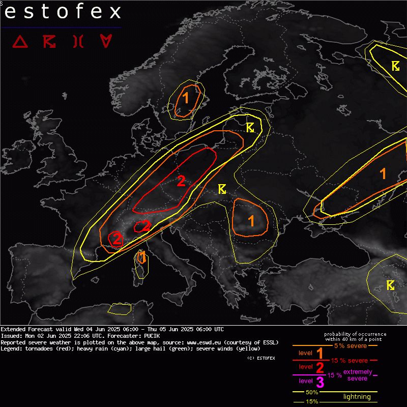
Heads-up SE Germany, N Austria and Czech Republic! Widespread severe storms are likely Wednesday afternoon into Wednesday night, with a risk of locally very large hail and damaging winds.
The current (extended) Estofex outlook can be found here: www.estofex.org
The current (extended) Estofex outlook can be found here: www.estofex.org
June 3, 2025 at 8:26 AM
Heads-up SE Germany, N Austria and Czech Republic! Widespread severe storms are likely Wednesday afternoon into Wednesday night, with a risk of locally very large hail and damaging winds.
The current (extended) Estofex outlook can be found here: www.estofex.org
The current (extended) Estofex outlook can be found here: www.estofex.org
And it seems to verify. There were several reports of large hail earlier today and ongoing supercells NW of Cologne just now.

May 31, 2025 at 5:49 PM
And it seems to verify. There were several reports of large hail earlier today and ongoing supercells NW of Cologne just now.
A high-level view of the Kit Carson supercell (complete with base and mammatus) in eastern Colorado late Friday as seen from the plane during the climb-out from Denver Airport. It was producing hail up to baseball size around that time. #cowx #stormhour


May 24, 2025 at 5:40 AM
A high-level view of the Kit Carson supercell (complete with base and mammatus) in eastern Colorado late Friday as seen from the plane during the climb-out from Denver Airport. It was producing hail up to baseball size around that time. #cowx #stormhour
HP supercell with hail up to tennis ball size just north of Lean, TX at around 4.45pm today. #txwx #stormhour @weatherandradarusa.bsky.social


May 22, 2025 at 11:18 PM
HP supercell with hail up to tennis ball size just north of Lean, TX at around 4.45pm today. #txwx #stormhour @weatherandradarusa.bsky.social
Some impressions from Sunday’s severe storms in NW #Oklahoma. While we didn’t quite make it to the very photogenic Arnett tornado in time (waited too long for the stratus to finally retreat N near Alva) we did capture amazing supercell structure that day. #stormhour @weatherandradar.bsky.social


May 20, 2025 at 2:36 PM
Some impressions from Sunday’s severe storms in NW #Oklahoma. While we didn’t quite make it to the very photogenic Arnett tornado in time (waited too long for the stratus to finally retreat N near Alva) we did capture amazing supercell structure that day. #stormhour @weatherandradar.bsky.social
Impressive supercell structure in south central Oklahoma on Saturday. This storm produced a tornado near Pauls Valley earlier west of our location. #okwx #stormhour @weatherandradar.bsky.social


May 18, 2025 at 5:25 AM
Impressive supercell structure in south central Oklahoma on Saturday. This storm produced a tornado near Pauls Valley earlier west of our location. #okwx #stormhour @weatherandradar.bsky.social
Tornado SE of Bell City, Missouri at around 4pm today. #mowx #kywx #stormhour @weatherandradar.bsky.social
May 16, 2025 at 10:31 PM
Tornado SE of Bell City, Missouri at around 4pm today. #mowx #kywx #stormhour @weatherandradar.bsky.social
Another “Down Day” in the Badlands National Park in South Dakota today. Beautiful, rugged landscape! 🪨


May 14, 2025 at 2:34 AM
Another “Down Day” in the Badlands National Park in South Dakota today. Beautiful, rugged landscape! 🪨
Watched some (very) high-based storms in SE #Montana after a hot, dry and windy day last night, with strong outflow and beautiful sunset scenery. #stormhour


May 12, 2025 at 3:19 PM
Watched some (very) high-based storms in SE #Montana after a hot, dry and windy day last night, with strong outflow and beautiful sunset scenery. #stormhour
Airplane view of a severe storm in the northwestern #Florida Panhandle en route to Denver this morning shortly after 11am EDT. There were two tornado reports in the area around that time. #stormhour

May 10, 2025 at 7:35 PM
Airplane view of a severe storm in the northwestern #Florida Panhandle en route to Denver this morning shortly after 11am EDT. There were two tornado reports in the area around that time. #stormhour
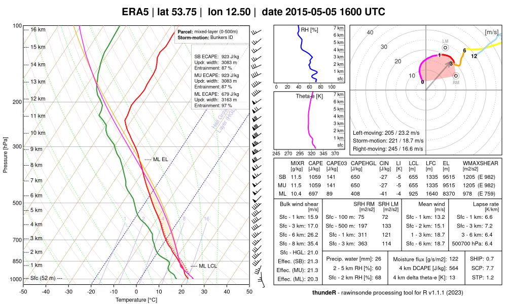
And an equally impressive environment by central European standards (e.g. ERA5 profile S of Rostock that afternoon). One of those occasions where spring/early summer dynamics meet moderately unstable air masses and create high-end tornadic setups.
May 6, 2025 at 2:42 PM
And an equally impressive environment by central European standards (e.g. ERA5 profile S of Rostock that afternoon). One of those occasions where spring/early summer dynamics meet moderately unstable air masses and create high-end tornadic setups.