


Adrian Leyser Sturm
@leysersturm.bsky.social
Meteorologist👨🎓
Storm Chaser & Photographer🌪📸
Forecaster & Radar/Tornado Expert
@dwdderwetterdienst.bsky.social
📍Oberursel • Frankfurt/M.• Idar-Oberstein | Germany
Storm Chaser & Photographer🌪📸
Forecaster & Radar/Tornado Expert
@dwdderwetterdienst.bsky.social
📍Oberursel • Frankfurt/M.• Idar-Oberstein | Germany

Freezing temperatures this morning in parts of Western and Central Europe. Especially in a band stretching from central France across the Alpine region and southern Germany to Czechia and Slovakia, temperatures are frequently below -10 °C, and in some places even below -20 °C. #Winter #Weather

January 5, 2026 at 6:34 AM
Böllerst du laut 🎆, denkst du leise 😴!
In diesem Sinne, einen guten Rutsch!
😊
#SicherInsNeueJahr
#Böllerciao
In diesem Sinne, einen guten Rutsch!
😊
#SicherInsNeueJahr
#Böllerciao
December 31, 2025 at 4:59 PM
Böllerst du laut 🎆, denkst du leise 😴!
In diesem Sinne, einen guten Rutsch!
😊
#SicherInsNeueJahr
#Böllerciao
In diesem Sinne, einen guten Rutsch!
😊
#SicherInsNeueJahr
#Böllerciao
Reposted by Adrian Leyser Sturm

2025 is in the climate books. 3rd warmest after 2023 and 2024 or tied 2nd warmest after 2024 (preliminary). The trend continues to be up, even tho it is within the expected range of warming given the known external factors.
Below the HadCRUT5 dataset ...
www.metoffice.gov.uk/hadobs/hadcr...
(1/2)
Below the HadCRUT5 dataset ...
www.metoffice.gov.uk/hadobs/hadcr...
(1/2)


December 30, 2025 at 10:34 AM
2025 is in the climate books. 3rd warmest after 2023 and 2024 or tied 2nd warmest after 2024 (preliminary). The trend continues to be up, even tho it is within the expected range of warming given the known external factors.
Below the HadCRUT5 dataset ...
www.metoffice.gov.uk/hadobs/hadcr...
(1/2)
Below the HadCRUT5 dataset ...
www.metoffice.gov.uk/hadobs/hadcr...
(1/2)
Interessant! Die "Meereshitzewelle" 2023/24 war eher kein Klimasprung, sondern Resultat interner Variabilität. Aber: Die Daten deuten darauf hin, dass das Klimasystem (noch)sensitiver gegenüber Antrieben sein könnte und die tieferliegende Erwärmung eventuell von den Modellen unterschätzt wird.

🌊📉 Sea surface temperatures have… come back down.
After the big global jump in 2023/24, SSTs are now back at below pre-jump levels in November (climatereanalyzer.org/clim/sst_dai...).
Climate surprise or expected? What role does climate variability play? Let’s try to unpack 👇
After the big global jump in 2023/24, SSTs are now back at below pre-jump levels in November (climatereanalyzer.org/clim/sst_dai...).
Climate surprise or expected? What role does climate variability play? Let’s try to unpack 👇

December 16, 2025 at 1:13 PM
Interessant! Die "Meereshitzewelle" 2023/24 war eher kein Klimasprung, sondern Resultat interner Variabilität. Aber: Die Daten deuten darauf hin, dass das Klimasystem (noch)sensitiver gegenüber Antrieben sein könnte und die tieferliegende Erwärmung eventuell von den Modellen unterschätzt wird.
Cloud structure characteristic of increased mineral dust concentration over the central Mediterranean. The so-called “Saharan Air Layer” (SAL) is located at an altitude of between 3 and 4 km, as illustrated by the backward trajectories based on GFS data.


December 16, 2025 at 8:33 AM
Cloud structure characteristic of increased mineral dust concentration over the central Mediterranean. The so-called “Saharan Air Layer” (SAL) is located at an altitude of between 3 and 4 km, as illustrated by the backward trajectories based on GFS data.
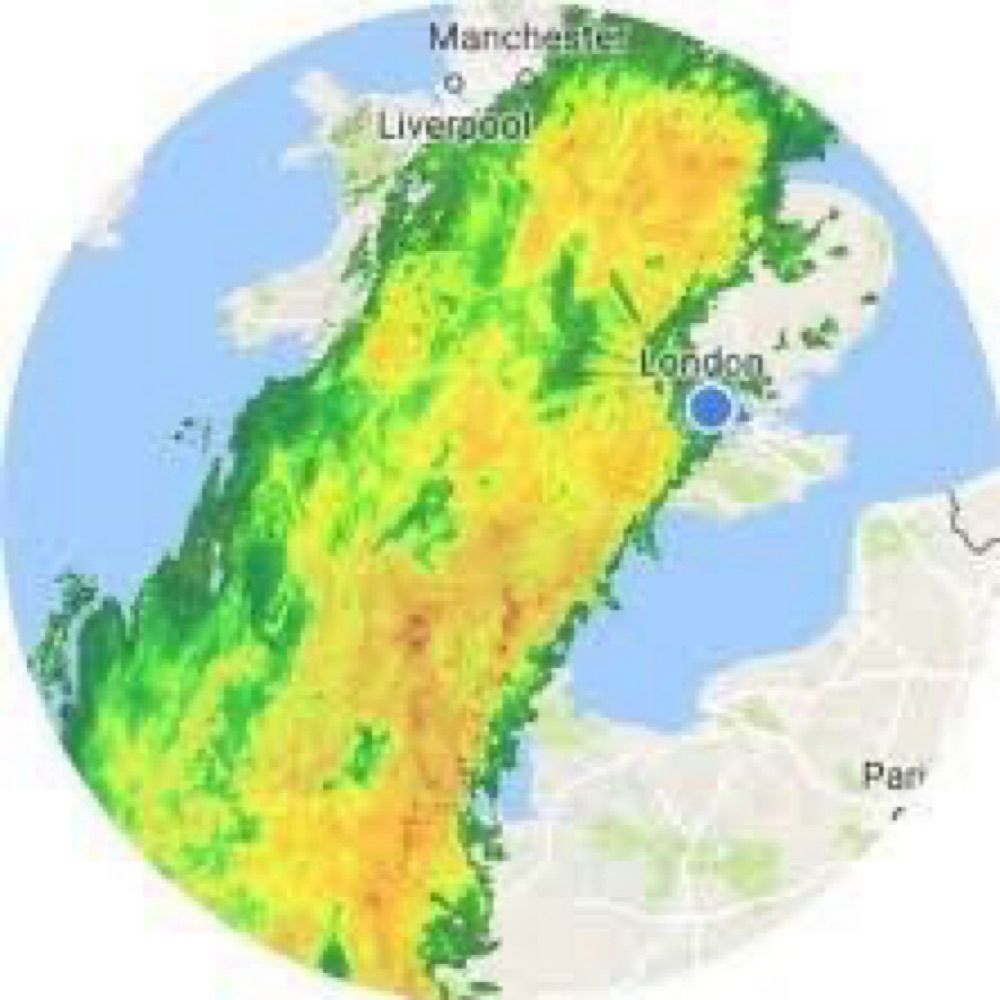
2025 wird nach zwei feuchten Jahren wohl wieder ein sehr trockenes. Während nur im Südwesten größere Gebiete eine ausgeglichene Bilanz (90-110 %) aufzuweisen haben und es regional sogar zu feucht war (>110 %), war es sonst vielfach sehr trocken (<70 %). Hier die angeeichten DWD-Radardaten.

December 15, 2025 at 1:20 PM
2025 wird nach zwei feuchten Jahren wohl wieder ein sehr trockenes. Während nur im Südwesten größere Gebiete eine ausgeglichene Bilanz (90-110 %) aufzuweisen haben und es regional sogar zu feucht war (>110 %), war es sonst vielfach sehr trocken (<70 %). Hier die angeeichten DWD-Radardaten.
When things get boring down below, it's sometimes worth taking a look from above: Orographic and shear-induced gravity waves at the top of a shallow stratus cloud layer, seen from MTG.

December 15, 2025 at 9:05 AM
When things get boring down below, it's sometimes worth taking a look from above: Orographic and shear-induced gravity waves at the top of a shallow stratus cloud layer, seen from MTG.
Winter has been completely banished from Europe for a while.
A notably “warm” start to meteorological winter across Europe only far north of Norway, Finland and Sweden have escaped.
The first half has been perhaps been the warmest on record this December though is not expected to exceed 2015... (1/2)
The first half has been perhaps been the warmest on record this December though is not expected to exceed 2015... (1/2)

December 15, 2025 at 8:42 AM
Winter has been completely banished from Europe for a while.
A change in the weather pattern is imminent! Around Christmas, a blocking will build up over N Europe, causing the westerly drift over W/C Europe to subside (transition to NAO-). However, due to the warm weather in recent weeks and poor snow cover, no significant onset of winter is expected yet.

December 15, 2025 at 7:23 AM
A change in the weather pattern is imminent! Around Christmas, a blocking will build up over N Europe, causing the westerly drift over W/C Europe to subside (transition to NAO-). However, due to the warm weather in recent weeks and poor snow cover, no significant onset of winter is expected yet.
Potential Shapiro-Keyser-Cyclone >> #StormBram << on Tuesday, according to the @dwdderwetterdienst.bsky.social forecast! Due to a rapid cyclogenesis the minimum surface pressure could drop below 960 hPa with serious impacts especially for Ireland and Scotland. But note the uncertainty (spread)!


December 7, 2025 at 11:39 AM
Potential Shapiro-Keyser-Cyclone >> #StormBram << on Tuesday, according to the @dwdderwetterdienst.bsky.social forecast! Due to a rapid cyclogenesis the minimum surface pressure could drop below 960 hPa with serious impacts especially for Ireland and Scotland. But note the uncertainty (spread)!
In the medium range, there is an enhanced risk of significant #storms over Western #Europe. Increasing horizontal temperature gradients are leading to a massive upper-level jet streak, at the left exit of which rapid “bombogenesis” is possible. This is associated with a potential positive NAO phase.

December 2, 2025 at 8:59 AM
In the medium range, there is an enhanced risk of significant #storms over Western #Europe. Increasing horizontal temperature gradients are leading to a massive upper-level jet streak, at the left exit of which rapid “bombogenesis” is possible. This is associated with a potential positive NAO phase.
Freezing cold in Central Europe! Severe frost in Germany with lows of up to -18 °C. Regionally, the coldest November night in 20 years.
A temperature of -34 °C was measured at Funtensee (a high-altitude karst lake @kachelmannwetter.com)
A temperature of -34 °C was measured at Funtensee (a high-altitude karst lake @kachelmannwetter.com)


November 23, 2025 at 12:50 PM
Freezing cold in Central Europe! Severe frost in Germany with lows of up to -18 °C. Regionally, the coldest November night in 20 years.
A temperature of -34 °C was measured at Funtensee (a high-altitude karst lake @kachelmannwetter.com)
A temperature of -34 °C was measured at Funtensee (a high-altitude karst lake @kachelmannwetter.com)
Record warm November day in southwestern #Germany. Temperatures above 20 °C, despite sunshine obscured by mineral dust. #temperature #records #weather


November 13, 2025 at 4:14 PM
Record warm November day in southwestern #Germany. Temperatures above 20 °C, despite sunshine obscured by mineral dust. #temperature #records #weather


The (possible record-breaking) Canarian #heat bubble (up to 35 °C!) will be sucked in by powerful Atlantic cyclones and carried as far as W-/C-Europe. By the middle of next week, temperatures of around 20 °C and locally around 25 °C are possible there too. #summerlike #weather #forecast #extreme
November 2, 2025 at 11:37 AM
The (possible record-breaking) Canarian #heat bubble (up to 35 °C!) will be sucked in by powerful Atlantic cyclones and carried as far as W-/C-Europe. By the middle of next week, temperatures of around 20 °C and locally around 25 °C are possible there too. #summerlike #weather #forecast #extreme
#Hurricane #Melissa from a #radar perspective. At first glance, the images may not be as stunning as the satellite images of the storm, but they impressively show how Melissa developed into an almost perfect storm with an almost perfect eye wall.
October 29, 2025 at 4:38 AM
#Hurricane #Melissa from a #radar perspective. At first glance, the images may not be as stunning as the satellite images of the storm, but they impressively show how Melissa developed into an almost perfect storm with an almost perfect eye wall.
Reposted by Adrian Leyser Sturm

Hurricane Melissa has just broken the record for the driest eye ever observed in a tropical cyclone, with a temperature of -4.75°C.
This is nothing short of astronomical.
This is nothing short of astronomical.

October 27, 2025 at 5:49 PM
Hurricane Melissa has just broken the record for the driest eye ever observed in a tropical cyclone, with a temperature of -4.75°C.
This is nothing short of astronomical.
This is nothing short of astronomical.
That doesn't look good...

October 22, 2025 at 1:12 PM
That doesn't look good...
The #severe #storm for parts of Western and Central #Europe has been named by @meteofrance.com: #Benjamin. It temporarily has the characteristics of a Shapiro-Keyser-Cyclone. The @dwdderwetterdienst.bsky.social forecast takes this into account with a frontal fracture.

October 22, 2025 at 9:35 AM
The #severe #storm for parts of Western and Central #Europe has been named by @meteofrance.com: #Benjamin. It temporarily has the characteristics of a Shapiro-Keyser-Cyclone. The @dwdderwetterdienst.bsky.social forecast takes this into account with a frontal fracture.

Further (extreme) heavy rainfall and floods for parts of #Spain due to #DANA (=Depresión Aislada en Niveles Altos) #Alice. After #Tarragona was affected yesterday, this time it is the region south of #Valencia and #Amposta. The satellite image shows a two huge, stationary storm systems.
October 13, 2025 at 11:02 AM
Potentially dangerous hybrid storm for the Southeast/East US starting this weekend? Frontal zone/trough could interact constructively with (sub-)tropical disturbance. Also interaction with future Tropical Storm Jerry? (->steering/moisture transport!). But very uncertain due to its complexity!


October 7, 2025 at 8:33 AM
Potentially dangerous hybrid storm for the Southeast/East US starting this weekend? Frontal zone/trough could interact constructively with (sub-)tropical disturbance. Also interaction with future Tropical Storm Jerry? (->steering/moisture transport!). But very uncertain due to its complexity!
During the week an omega blocking pattern will build up. It sets up quite far to the west, so that the large-scale circulation “ATR” (Altantic Ridge) is favored. This will bring calm weather to large parts of W/C-Europe and unsettled weather with heavy precipitation to the southeast and east.


October 6, 2025 at 11:29 AM
During the week an omega blocking pattern will build up. It sets up quite far to the west, so that the large-scale circulation “ATR” (Altantic Ridge) is favored. This will bring calm weather to large parts of W/C-Europe and unsettled weather with heavy precipitation to the southeast and east.
Updated #tornado statistics and illustrations from #Germany from our colleague @meteomabe.bsky.social.

Your probably all know the #tornado stripes for Germany that I have posted several times. Starting at 2000 since with a robust dataset from then on. It shows a clear maxium for the years surounding the recors year 2006. #showyourstripes 1/3

October 6, 2025 at 7:29 AM
Updated #tornado statistics and illustrations from #Germany from our colleague @meteomabe.bsky.social.