


London & Southeast🔅
@thesnowdreamer.bsky.social
Pinned

End of Week Forecast | TheSnowDreamer
Get more from TheSnowDreamer on Patreon
www.patreon.com
Impactful weather conditions 🌧️ are expected to hit much of England and Wales tomorrow with the arrival of Storm Claudia (named by Spanish met).
Membership starts from as little as 50p for the first month use code 'ED74C' to get 70% off any tier.
www.patreon.com/posts/143511...
Membership starts from as little as 50p for the first month use code 'ED74C' to get 70% off any tier.
www.patreon.com/posts/143511...
18.3c the confirmed max at Heathrow that’s warmest it has ever been this late in year (1948-2025).
Amazing how there are some people in London dressed like they’re going on Arctic expedition.
Today’s preliminary max of 18C (64F) at London Heathrow - exceptionally mild for mid November. It smashes previous daily highest max record of 16.5C set on this date in 2009.
Today’s preliminary max of 18C (64F) at London Heathrow - exceptionally mild for mid November. It smashes previous daily highest max record of 16.5C set on this date in 2009.
November 13, 2025 at 8:38 PM
18.3c the confirmed max at Heathrow that’s warmest it has ever been this late in year (1948-2025).
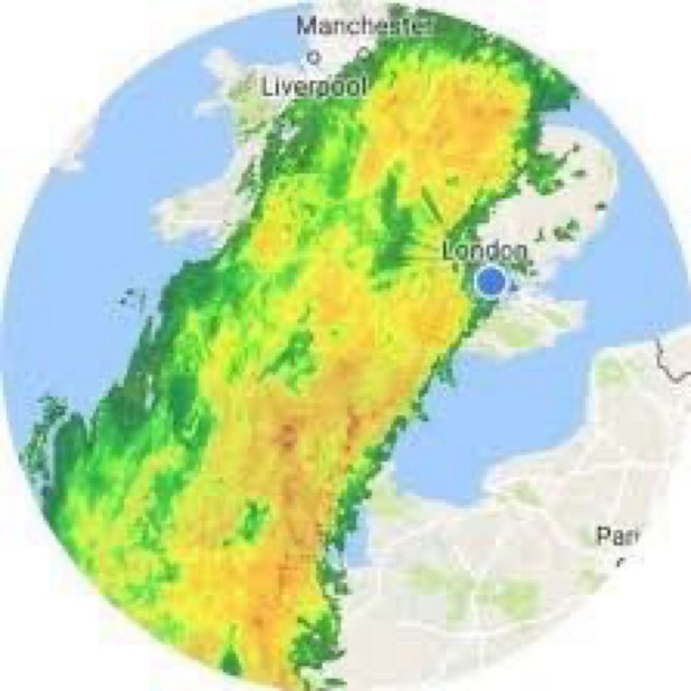
Here arrives exceptionally wet 36 hours for large swathes of England & Wales…. #Claudia
Heaviest and most persistent rain is now fortunately expected to spare London tomorrow. More targeting Midlands…
Heaviest and most persistent rain is now fortunately expected to spare London tomorrow. More targeting Midlands…

November 13, 2025 at 7:57 PM
Here arrives exceptionally wet 36 hours for large swathes of England & Wales…. #Claudia
Heaviest and most persistent rain is now fortunately expected to spare London tomorrow. More targeting Midlands…
Heaviest and most persistent rain is now fortunately expected to spare London tomorrow. More targeting Midlands…
Impactful weather conditions 🌧️ are expected to hit much of England and Wales tomorrow with the arrival of Storm Claudia (named by Spanish met).
Membership starts from as little as 50p for the first month use code 'ED74C' to get 70% off any tier.
www.patreon.com/posts/143511...
Membership starts from as little as 50p for the first month use code 'ED74C' to get 70% off any tier.
www.patreon.com/posts/143511...
End of Week Forecast | TheSnowDreamer
Get more from TheSnowDreamer on Patreon
www.patreon.com
November 13, 2025 at 7:46 PM
Impactful weather conditions 🌧️ are expected to hit much of England and Wales tomorrow with the arrival of Storm Claudia (named by Spanish met).
Membership starts from as little as 50p for the first month use code 'ED74C' to get 70% off any tier.
www.patreon.com/posts/143511...
Membership starts from as little as 50p for the first month use code 'ED74C' to get 70% off any tier.
www.patreon.com/posts/143511...
Amazing how there are some people in London dressed like they’re going on Arctic expedition.
Today’s preliminary max of 18C (64F) at London Heathrow - exceptionally mild for mid November. It smashes previous daily highest max record of 16.5C set on this date in 2009.
Today’s preliminary max of 18C (64F) at London Heathrow - exceptionally mild for mid November. It smashes previous daily highest max record of 16.5C set on this date in 2009.
November 13, 2025 at 5:48 PM
Amazing how there are some people in London dressed like they’re going on Arctic expedition.
Today’s preliminary max of 18C (64F) at London Heathrow - exceptionally mild for mid November. It smashes previous daily highest max record of 16.5C set on this date in 2009.
Today’s preliminary max of 18C (64F) at London Heathrow - exceptionally mild for mid November. It smashes previous daily highest max record of 16.5C set on this date in 2009.
Reposted by London & Southeast🔅

The forecast model consensus for tomorrow's wettest weather is now further north than most of yesterday's runs had it.
Result being, southernmost counties look to be spared the worst of it, but 40+ mm in 24 hours may be experienced as far north as Leeds.
Result being, southernmost counties look to be spared the worst of it, but 40+ mm in 24 hours may be experienced as far north as Leeds.


November 13, 2025 at 9:37 AM
The forecast model consensus for tomorrow's wettest weather is now further north than most of yesterday's runs had it.
Result being, southernmost counties look to be spared the worst of it, but 40+ mm in 24 hours may be experienced as far north as Leeds.
Result being, southernmost counties look to be spared the worst of it, but 40+ mm in 24 hours may be experienced as far north as Leeds.
The earliest Sudden Stratospheric Warming (SSW) event in history is a distinct possibility in final week of November.
November 12, 2025 at 8:19 PM
The earliest Sudden Stratospheric Warming (SSW) event in history is a distinct possibility in final week of November.
Hi Liza, I’ll keep that in mind. Would like to hear what others think.
Trouble is character limit on here, I suppose I could cut them down.
Trouble is character limit on here, I suppose I could cut them down.

I follow you and I find your posts useful, but I really wish you would just post the same text & images here rather than screenshots from X with no alt text.
Would you please consider doing that? It would make the images much easier to see, among other advantages.
Would you please consider doing that? It would make the images much easier to see, among other advantages.
November 12, 2025 at 7:41 PM
Hi Liza, I’ll keep that in mind. Would like to hear what others think.
Trouble is character limit on here, I suppose I could cut them down.
Trouble is character limit on here, I suppose I could cut them down.


Friday looks like a shocker… #weatheraware

November 12, 2025 at 1:26 PM
Friday looks like a shocker… #weatheraware
Temperatures at 1.5km above London will be going from +8C tomorrow to -5C early next week. Well below average.
Certainly going to be noticeable sudden cooling after what will have been warmest first half to November on record.
Certainly going to be noticeable sudden cooling after what will have been warmest first half to November on record.

November 11, 2025 at 5:40 PM
Temperatures at 1.5km above London will be going from +8C tomorrow to -5C early next week. Well below average.
Certainly going to be noticeable sudden cooling after what will have been warmest first half to November on record.
Certainly going to be noticeable sudden cooling after what will have been warmest first half to November on record.
Something of a shock to system coming soon…
Max temperatures over next few days will be closer to April values by next Monday they will be closer to midwinter.
The colder weather next week looks mostly dry with crisp sunshine featuring. A recipe for frosty nights including urban areas.
Max temperatures over next few days will be closer to April values by next Monday they will be closer to midwinter.
The colder weather next week looks mostly dry with crisp sunshine featuring. A recipe for frosty nights including urban areas.

November 11, 2025 at 5:13 PM
Something of a shock to system coming soon…
Max temperatures over next few days will be closer to April values by next Monday they will be closer to midwinter.
The colder weather next week looks mostly dry with crisp sunshine featuring. A recipe for frosty nights including urban areas.
Max temperatures over next few days will be closer to April values by next Monday they will be closer to midwinter.
The colder weather next week looks mostly dry with crisp sunshine featuring. A recipe for frosty nights including urban areas.

Balmy November nights - lows of 13C expected in London overnight. As warm as it should be in middle of afternoon.
Appreciating the heating savings?
Appreciating the heating savings?

November 9, 2025 at 9:05 PM
Balmy November nights - lows of 13C expected in London overnight. As warm as it should be in middle of afternoon.
Appreciating the heating savings?
Appreciating the heating savings?
My latest thoughts on week ahead weather. A predominantly gloomy but very mild week. Major change in feel next weekend, Arctic air spreading south.....
Running a pre-winter sale, use code 'ED74C' to get 70% off your first month 😀
www.patreon.com/posts/143188...
Running a pre-winter sale, use code 'ED74C' to get 70% off your first month 😀
www.patreon.com/posts/143188...

Noticeably mild conditions in the week ahead before much colder conditions spread from N | TheSnowDreamer
Get more from TheSnowDreamer on Patreon
www.patreon.com
November 9, 2025 at 5:08 PM
My latest thoughts on week ahead weather. A predominantly gloomy but very mild week. Major change in feel next weekend, Arctic air spreading south.....
Running a pre-winter sale, use code 'ED74C' to get 70% off your first month 😀
www.patreon.com/posts/143188...
Running a pre-winter sale, use code 'ED74C' to get 70% off your first month 😀
www.patreon.com/posts/143188...
Thus far the average max at London Heathrow has been 16.2C +5C above already warmed 1991-2020 monthly average high.
So the outlook will be a shock - expecting widespread frosts into early next week with temperatures more typical of January values. Feeling even more chillier as it has been so mild.
So the outlook will be a shock - expecting widespread frosts into early next week with temperatures more typical of January values. Feeling even more chillier as it has been so mild.
November 9, 2025 at 2:24 PM
Thus far the average max at London Heathrow has been 16.2C +5C above already warmed 1991-2020 monthly average high.
So the outlook will be a shock - expecting widespread frosts into early next week with temperatures more typical of January values. Feeling even more chillier as it has been so mild.
So the outlook will be a shock - expecting widespread frosts into early next week with temperatures more typical of January values. Feeling even more chillier as it has been so mild.
Colder weather (much colder to of late) on near horizon? #ukweather

November 8, 2025 at 9:47 PM
Colder weather (much colder to of late) on near horizon? #ukweather
Very mild throughout next week, but guidance is growing more confident on colder conditions developing thereafter. More acutely felt after what will have been, an exceptionally mild first half to Nov.
November 8, 2025 at 12:23 PM
Very mild throughout next week, but guidance is growing more confident on colder conditions developing thereafter. More acutely felt after what will have been, an exceptionally mild first half to Nov.
Noticing unseasonable mildness?
Well can confirm a record “warm” opening week to November in London area….
Well can confirm a record “warm” opening week to November in London area….

November 7, 2025 at 5:31 PM
Noticing unseasonable mildness?
Well can confirm a record “warm” opening week to November in London area….
Well can confirm a record “warm” opening week to November in London area….
#ukweather interesting possibilities of considerable temperature falls deeper into November, after a presumably record warm first half to Nov.

November 6, 2025 at 10:52 PM
#ukweather interesting possibilities of considerable temperature falls deeper into November, after a presumably record warm first half to Nov.
Like every Thursday evening, I take a closer look at the end of week weather. There's not much to feast your eyes on but Saturday is looking to feature sunnier spells.
This blog post is accessible to all patrons. Join us!
www.patreon.com/posts/142989...
This blog post is accessible to all patrons. Join us!
www.patreon.com/posts/142989...

End of Week Forecast | TheSnowDreamer
Get more from TheSnowDreamer on Patreon
www.patreon.com
November 6, 2025 at 6:39 PM
Like every Thursday evening, I take a closer look at the end of week weather. There's not much to feast your eyes on but Saturday is looking to feature sunnier spells.
This blog post is accessible to all patrons. Join us!
www.patreon.com/posts/142989...
This blog post is accessible to all patrons. Join us!
www.patreon.com/posts/142989...
I can now confirm we have fallen a little short with a max of 18.2C making it tied 4th warmest Nov day on record at LHR (1948-2025).
If ☁️ was not as extensive the 2010 record would’ve been beaten.
18.5C - 4 Nov 2010
18.4C - 6 Nov 2003
18.3C - 1 Nov 1984
18.2C - 5 Nov 2025*****
18.2C - 3 Nov 1994
If ☁️ was not as extensive the 2010 record would’ve been beaten.
18.5C - 4 Nov 2010
18.4C - 6 Nov 2003
18.3C - 1 Nov 1984
18.2C - 5 Nov 2025*****
18.2C - 3 Nov 1994
Stay tuned it’s possible highest recorded November temperature at #London Heathrow was broken today.
Hourly ob of 17.9C at noon with some warm sunshine at time, possible it went higher. Undoubtedly if today was sunny, it would have been smashed. Exceptionally warm air pervades Europe….
Hourly ob of 17.9C at noon with some warm sunshine at time, possible it went higher. Undoubtedly if today was sunny, it would have been smashed. Exceptionally warm air pervades Europe….
November 5, 2025 at 6:38 PM
I can now confirm we have fallen a little short with a max of 18.2C making it tied 4th warmest Nov day on record at LHR (1948-2025).
If ☁️ was not as extensive the 2010 record would’ve been beaten.
18.5C - 4 Nov 2010
18.4C - 6 Nov 2003
18.3C - 1 Nov 1984
18.2C - 5 Nov 2025*****
18.2C - 3 Nov 1994
If ☁️ was not as extensive the 2010 record would’ve been beaten.
18.5C - 4 Nov 2010
18.4C - 6 Nov 2003
18.3C - 1 Nov 1984
18.2C - 5 Nov 2025*****
18.2C - 3 Nov 1994
Stay tuned it’s possible highest recorded November temperature at #London Heathrow was broken today.
Hourly ob of 17.9C at noon with some warm sunshine at time, possible it went higher. Undoubtedly if today was sunny, it would have been smashed. Exceptionally warm air pervades Europe….
Hourly ob of 17.9C at noon with some warm sunshine at time, possible it went higher. Undoubtedly if today was sunny, it would have been smashed. Exceptionally warm air pervades Europe….

November 5, 2025 at 4:37 PM
Stay tuned it’s possible highest recorded November temperature at #London Heathrow was broken today.
Hourly ob of 17.9C at noon with some warm sunshine at time, possible it went higher. Undoubtedly if today was sunny, it would have been smashed. Exceptionally warm air pervades Europe….
Hourly ob of 17.9C at noon with some warm sunshine at time, possible it went higher. Undoubtedly if today was sunny, it would have been smashed. Exceptionally warm air pervades Europe….
Impressive Arctic blast while swift will affect large portions of eastern US early next week. More notably cold weather extending unusually far S for time of year, associated with polar vortex.
Frost possible into Florida Panhandle with 850hPa temps signalled 20C below average. Before much of UK!
Frost possible into Florida Panhandle with 850hPa temps signalled 20C below average. Before much of UK!


November 4, 2025 at 7:37 PM
Impressive Arctic blast while swift will affect large portions of eastern US early next week. More notably cold weather extending unusually far S for time of year, associated with polar vortex.
Frost possible into Florida Panhandle with 850hPa temps signalled 20C below average. Before much of UK!
Frost possible into Florida Panhandle with 850hPa temps signalled 20C below average. Before much of UK!
