


Russ Schumacher
@rschumacher.cloud
"an upbeat atmospheric science professor" -- theverge | sometimes it snows in April | Fort Collins, Colorado | personal account
Pinned
Russ Schumacher
@rschumacher.cloud
· Aug 13
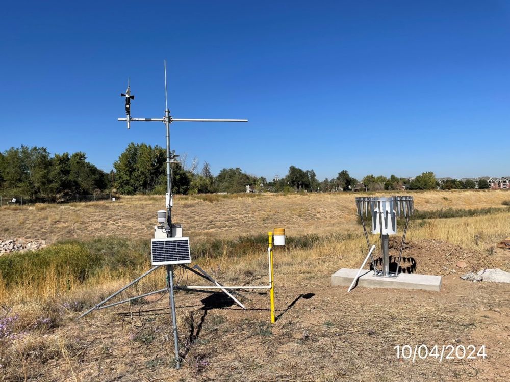
CoAgMET---the Colorado Agricultural Meteorological network, aka Colorado's Mesonet---was recently recognized for over 30 years of data collection. Read more about the award and the network in this story from CSU Source. Here's to 30 more years of valuable weather and climate information! #cowx
CSU Colorado Mesonet recognized by American Association of State Climatologists for over thirty years of service - Walter Scott, Jr. College of Engineering
The Colorado Agricultural and Meteorological Network, known as CoAgMET, was recognized with the American Association of State Climatologists 30 Year Mesonet Award for contributing more than 30 years o...
engr.source.colostate.edu
A lot of people still don’t know that we have a mesonet in Colorado — and we’re working to make it better every year! #cowx
Reposted by Russ Schumacher

They are really planning to go through with these cuts at Nebraska, despite recommendations not to. Unbelievable.
If you want to hire highly qualified, very successful earth and atmospheric sciences faculty in teaching and research, quite a few are probably looking for jobs for next year.
If you want to hire highly qualified, very successful earth and atmospheric sciences faculty in teaching and research, quite a few are probably looking for jobs for next year.
Final Budget Reduction Plan | Budget Process | Nebraska
budgetprocess.unl.edu
November 10, 2025 at 11:19 PM
They are really planning to go through with these cuts at Nebraska, despite recommendations not to. Unbelievable.
If you want to hire highly qualified, very successful earth and atmospheric sciences faculty in teaching and research, quite a few are probably looking for jobs for next year.
If you want to hire highly qualified, very successful earth and atmospheric sciences faculty in teaching and research, quite a few are probably looking for jobs for next year.

Reposted by Russ Schumacher

I first wrote and cron’d the script that makes these @NWSSPC upper air maps in November 1998. It’s been running and making the twice-daily UA maps for the past 27 years at this URL: www.spc.noaa.gov/obswx/maps/. That’s over 138,000 maps online and it’s still going!
November 10, 2025 at 9:18 PM
I first wrote and cron’d the script that makes these @NWSSPC upper air maps in November 1998. It’s been running and making the twice-daily UA maps for the past 27 years at this URL: www.spc.noaa.gov/obswx/maps/. That’s over 138,000 maps online and it’s still going!
Reposted by Russ Schumacher

Water Year 2025 was the 10th warmest on record for Colorado and featured drought, fires, floods, and even a record-setting snowstorm. We recap all that and more in our Colorado Water Year 2025 Summary! ⬇️
Home
co-water-year-2025.my.canva.site
November 10, 2025 at 6:06 PM
Water Year 2025 was the 10th warmest on record for Colorado and featured drought, fires, floods, and even a record-setting snowstorm. We recap all that and more in our Colorado Water Year 2025 Summary! ⬇️
Reposted by Russ Schumacher

An update from the NWS on the potential snow event. Read it.
One key: “…As a result, the expectation is for the lake effect snow bands to be unusually intense with peak snow rates of 3 to locally 5 inches per hour, frequent lightning and thunder, and pockets of hail.”
#ILwx #Chicago #ChicagoWX
One key: “…As a result, the expectation is for the lake effect snow bands to be unusually intense with peak snow rates of 3 to locally 5 inches per hour, frequent lightning and thunder, and pockets of hail.”
#ILwx #Chicago #ChicagoWX

November 9, 2025 at 4:51 PM
An update from the NWS on the potential snow event. Read it.
One key: “…As a result, the expectation is for the lake effect snow bands to be unusually intense with peak snow rates of 3 to locally 5 inches per hour, frequent lightning and thunder, and pockets of hail.”
#ILwx #Chicago #ChicagoWX
One key: “…As a result, the expectation is for the lake effect snow bands to be unusually intense with peak snow rates of 3 to locally 5 inches per hour, frequent lightning and thunder, and pockets of hail.”
#ILwx #Chicago #ChicagoWX
Reposted by Russ Schumacher

Millennials haven’t had easy lives but at least we’ll always have this beat drop at 3:07

November 7, 2025 at 4:10 PM
Millennials haven’t had easy lives but at least we’ll always have this beat drop at 3:07
Reposted by Russ Schumacher
“Some of the smaller, more local reservoirs saw significant improvement,” said Peter Goble, a climatologist for the Colorado Climate Center at Colorado State University. “If we look at our reservoir giants, like Powell and Mead, unfortunately at that scale this is kind of a drop in the bucket.”

October storms brought damaging floods to southwestern Colorado, but also much needed drought relief
The October floods in Colorado damaged homes and upended lives, but there was one silver lining: The water also replenished reservoirs.
coloradosun.com
November 7, 2025 at 1:11 PM
“Some of the smaller, more local reservoirs saw significant improvement,” said Peter Goble, a climatologist for the Colorado Climate Center at Colorado State University. “If we look at our reservoir giants, like Powell and Mead, unfortunately at that scale this is kind of a drop in the bucket.”
Reposted by Russ Schumacher

As premiums skyrocket, Colorado now one of most expensive states in U.S. for home insurance trib.al/0r4kTbA

As premiums skyrocket, Colorado now one of most expensive states in U.S. for home insurance
Colorado is No. 2 in the country for hail insurance claims and the number of properties in areas at risk for wildfires.
trib.al
November 7, 2025 at 12:05 PM
As premiums skyrocket, Colorado now one of most expensive states in U.S. for home insurance trib.al/0r4kTbA
Reposted by Russ Schumacher
I was going to wait until the shutdown was over but the cat is out if the bag. My first journal article is now live!
Convective Mode Classification and Distribution of Contiguous United States Tornado Events from 2003–2023 in: Weather and Forecasting - Ahead of print share.google/M3ty4pVs5Tld...
Convective Mode Classification and Distribution of Contiguous United States Tornado Events from 2003–2023 in: Weather and Forecasting - Ahead of print share.google/M3ty4pVs5Tld...

Convective Mode Classification and Distribution of Contiguous United States Tornado Events from 2003–2023
Abstract Tornadoes and severe thunderstorms represent a significant threat to life and property in the United States annually. Approximately one thousand tornadoes, two-hundred being significant (F/EF-2+), are documented on average every year. Using archived radar and Storm Data storm report information, 21 912 tornado grid hours were manually analyzed for convective mode from the years 2003–2023. This dataset builds upon prior work by Smith et al. (2012) (hereafter S12) by more than doubling the sample size to produce a robust, multidecadal climatology of tornadoes by convective mode. Comparisons were made between tornado samples spanning 2003–2011 and 2012–2023 to assess changes in the frequency and spatial occurrence of tornadoes. Convective mode characterization consisted of a subjective analysis of WSR-88D imagery into three categories: 1) supercell, 2) quasi–linear convective system (QLCS), and 3) disorganized. Spatial climatologies of the different modes were performed and Kernel Density Estimate plots of events per decade were generated as in S12. The highest climatological frequency for tornadic supercells is reaffirmed to extend from KS and OK east-southeastward to MS and AL, while QLCS tornadoes are more frequent from the northern Gulf Coast states into the lower Ohio River Valley. Comparing the new sample to the original, QLCS tornado relative frequency increased by over 100%. Substantial variation in QLCS tornado occurrence may be due to non-meteorological factors such as dual polarization radar and different observing/reporting practices.
share.google
November 5, 2025 at 3:18 PM
I was going to wait until the shutdown was over but the cat is out if the bag. My first journal article is now live!
Convective Mode Classification and Distribution of Contiguous United States Tornado Events from 2003–2023 in: Weather and Forecasting - Ahead of print share.google/M3ty4pVs5Tld...
Convective Mode Classification and Distribution of Contiguous United States Tornado Events from 2003–2023 in: Weather and Forecasting - Ahead of print share.google/M3ty4pVs5Tld...
Reposted by Russ Schumacher

You can see the smoke plume from the UPS plane crash in Louisville, Kentucky from the KLVX radar
November 4, 2025 at 11:33 PM
You can see the smoke plume from the UPS plane crash in Louisville, Kentucky from the KLVX radar
getting ready for a day discussing extreme rainfall and mountain meteorology. after you vote, join in on the fun here:
www.nationalacademies.org
November 4, 2025 at 3:08 PM
getting ready for a day discussing extreme rainfall and mountain meteorology. after you vote, join in on the fun here:
Reposted by Russ Schumacher

Undergraduate opportunity! 📣 The NSF SOARS program is open for applications! SOARS is an undergrad-grad bridge program focusing on promoting and supporting research, mentoring, and community.
Learn more about eligibility and the app process:
ucar.wd5.myworkdayjobs.com/en-US/UCAR_C...
Learn more about eligibility and the app process:
ucar.wd5.myworkdayjobs.com/en-US/UCAR_C...

2026 NSF SOARS® First-Year Protege
Job Description Summary: UCAR is excited to announce the application opening of the U.S. National Science Foundation (NSF) Significant Opportunities in Atmospheric Research and Science (SOARS) program...
ucar.wd5.myworkdayjobs.com
November 3, 2025 at 8:57 PM
Undergraduate opportunity! 📣 The NSF SOARS program is open for applications! SOARS is an undergrad-grad bridge program focusing on promoting and supporting research, mentoring, and community.
Learn more about eligibility and the app process:
ucar.wd5.myworkdayjobs.com/en-US/UCAR_C...
Learn more about eligibility and the app process:
ucar.wd5.myworkdayjobs.com/en-US/UCAR_C...
Reposted by Russ Schumacher
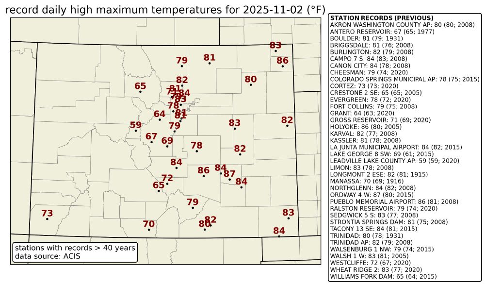
Lots of new daily high temperature records were set across Colorado yesterday, some by more than 5℉! ☀️
November 3, 2025 at 6:55 PM
Lots of new daily high temperature records were set across Colorado yesterday, some by more than 5℉! ☀️
Reposted by Russ Schumacher

Did not expect one of the best paragraphs I’d read about baseball would come from an Irish newspaper
www.irishexaminer.com/sport-column...
www.irishexaminer.com/sport-column...

November 2, 2025 at 2:22 PM
Did not expect one of the best paragraphs I’d read about baseball would come from an Irish newspaper
www.irishexaminer.com/sport-column...
www.irishexaminer.com/sport-column...


Reposted by Russ Schumacher

I’ll bet you never heard of an incredible weather event that happened 34 years ago on this very date, one so rarely mentioned yet so epic in scale, seemingly unknown to younger Minnesotas who lean forward with anticipation and excitement as survivors begin the tale of a Halloween blizzard that
October 31, 2025 at 11:09 AM
I’ll bet you never heard of an incredible weather event that happened 34 years ago on this very date, one so rarely mentioned yet so epic in scale, seemingly unknown to younger Minnesotas who lean forward with anticipation and excitement as survivors begin the tale of a Halloween blizzard that
Reposted by Russ Schumacher

Multi-panel view of the last few days of Hurricane Melissa:
↖️ GOES-19 infrared brightness temp
↗️ GOES-19 visible satellite
↙️ Hurricane hunter planes & flight paths
↘️ Recon-derived flight level wind swath
⬇️ Estimated minimum pressure from recon dropsondes
↖️ GOES-19 infrared brightness temp
↗️ GOES-19 visible satellite
↙️ Hurricane hunter planes & flight paths
↘️ Recon-derived flight level wind swath
⬇️ Estimated minimum pressure from recon dropsondes
October 29, 2025 at 10:14 PM
Multi-panel view of the last few days of Hurricane Melissa:
↖️ GOES-19 infrared brightness temp
↗️ GOES-19 visible satellite
↙️ Hurricane hunter planes & flight paths
↘️ Recon-derived flight level wind swath
⬇️ Estimated minimum pressure from recon dropsondes
↖️ GOES-19 infrared brightness temp
↗️ GOES-19 visible satellite
↙️ Hurricane hunter planes & flight paths
↘️ Recon-derived flight level wind swath
⬇️ Estimated minimum pressure from recon dropsondes

Reposted by Russ Schumacher

#Melissa's landfall intensity of 185 mph/892 mb ties it with the Florida Key's Labor Day Hurricane of 1935 as the record minimum pressure of any TC making landfall *anywhere* the NATL basin. I feel for the residents of #Jamaica 😞
Zoomed in G19 visible meso loop courtesy of @cyclonicwx.bsky.social
Zoomed in G19 visible meso loop courtesy of @cyclonicwx.bsky.social
October 28, 2025 at 5:14 PM
#Melissa's landfall intensity of 185 mph/892 mb ties it with the Florida Key's Labor Day Hurricane of 1935 as the record minimum pressure of any TC making landfall *anywhere* the NATL basin. I feel for the residents of #Jamaica 😞
Zoomed in G19 visible meso loop courtesy of @cyclonicwx.bsky.social
Zoomed in G19 visible meso loop courtesy of @cyclonicwx.bsky.social
Reposted by Russ Schumacher

Per NOAA/AOML/HRD’s Sim Aberson, the 219 kt reading will be the fastest wind ever measured by a dropsonde if it passes final quality-control checks.

This is hands down the most extraordinary dropsonde in Atlantic recon history.

October 28, 2025 at 3:41 PM
Per NOAA/AOML/HRD’s Sim Aberson, the 219 kt reading will be the fastest wind ever measured by a dropsonde if it passes final quality-control checks.
Reposted by Russ Schumacher

You VERY rarely ever see a satellite presentation like this anywhere in the world. And you certainly don't expect to see it this close to a mountainous island.
As of 5am EDT on Tuesday, #Melissa is the 8th strongest Atlantic hurricane on record by central pressure (901 mb).
As of 5am EDT on Tuesday, #Melissa is the 8th strongest Atlantic hurricane on record by central pressure (901 mb).
October 28, 2025 at 11:36 AM
You VERY rarely ever see a satellite presentation like this anywhere in the world. And you certainly don't expect to see it this close to a mountainous island.
As of 5am EDT on Tuesday, #Melissa is the 8th strongest Atlantic hurricane on record by central pressure (901 mb).
As of 5am EDT on Tuesday, #Melissa is the 8th strongest Atlantic hurricane on record by central pressure (901 mb).
Reposted by Russ Schumacher

August 23, 2017 vs. September 17, 2017
This is what the defoliation looked like across the Virgin Islands after Hurricane Irma swept the region as a Cat 5—and the worst winds actually missed the islands to the north.
A swath of western Jamaica will look the same when the skies clear in a few days.
This is what the defoliation looked like across the Virgin Islands after Hurricane Irma swept the region as a Cat 5—and the worst winds actually missed the islands to the north.
A swath of western Jamaica will look the same when the skies clear in a few days.


October 27, 2025 at 8:11 PM
August 23, 2017 vs. September 17, 2017
This is what the defoliation looked like across the Virgin Islands after Hurricane Irma swept the region as a Cat 5—and the worst winds actually missed the islands to the north.
A swath of western Jamaica will look the same when the skies clear in a few days.
This is what the defoliation looked like across the Virgin Islands after Hurricane Irma swept the region as a Cat 5—and the worst winds actually missed the islands to the north.
A swath of western Jamaica will look the same when the skies clear in a few days.
Reposted by Russ Schumacher

From a crewmember on yesterday's Teal 74 mission into now-Category 5 Hurricane #Melissa. As clear of an eye as you will see in the Atlantic basin.
October 27, 2025 at 4:11 PM
From a crewmember on yesterday's Teal 74 mission into now-Category 5 Hurricane #Melissa. As clear of an eye as you will see in the Atlantic basin.
Reposted by Russ Schumacher

"The NOAA aircraft left the storm early after
experiencing severe turbulence in the southwestern eyewall."
These men and women are not being paid due to the US government shutdown. Not to mention that according to AOML's director emeritus Robert Atlas, they are down 40-50% staff. #Melissa
experiencing severe turbulence in the southwestern eyewall."
These men and women are not being paid due to the US government shutdown. Not to mention that according to AOML's director emeritus Robert Atlas, they are down 40-50% staff. #Melissa
October 27, 2025 at 3:49 PM
"The NOAA aircraft left the storm early after
experiencing severe turbulence in the southwestern eyewall."
These men and women are not being paid due to the US government shutdown. Not to mention that according to AOML's director emeritus Robert Atlas, they are down 40-50% staff. #Melissa
experiencing severe turbulence in the southwestern eyewall."
These men and women are not being paid due to the US government shutdown. Not to mention that according to AOML's director emeritus Robert Atlas, they are down 40-50% staff. #Melissa