


Michael Anderson
@manderson003.bsky.social
He/him. From Hamburg, Germany. Interested in weather + climate, music and gaming.
Reposted by Michael Anderson

This has to be unheard of. With an extraordinary peak flash rate of 699 flashes per minute just prior to landfall in Jamaica, Melissa probably set the record for the most prolific inner-core lightning outbreak ever recorded in an Atlantic hurricane.

November 6, 2025 at 5:40 PM
This has to be unheard of. With an extraordinary peak flash rate of 699 flashes per minute just prior to landfall in Jamaica, Melissa probably set the record for the most prolific inner-core lightning outbreak ever recorded in an Atlantic hurricane.
We set two monthly records at stations with long period of record today, including at Zugspitze, Germany's highest mountain.
New record 10.5°C, beating the 9.9°C set last year. Records since 1900.
18.6°C in Wernigerode-Schierke, beating 17.5°C set in 1955, Records since 1903.
New record 10.5°C, beating the 9.9°C set last year. Records since 1900.
18.6°C in Wernigerode-Schierke, beating 17.5°C set in 1955, Records since 1903.

November 6, 2025 at 8:01 PM
We set two monthly records at stations with long period of record today, including at Zugspitze, Germany's highest mountain.
New record 10.5°C, beating the 9.9°C set last year. Records since 1900.
18.6°C in Wernigerode-Schierke, beating 17.5°C set in 1955, Records since 1903.
New record 10.5°C, beating the 9.9°C set last year. Records since 1900.
18.6°C in Wernigerode-Schierke, beating 17.5°C set in 1955, Records since 1903.
The full moon just now. Taken with my phone

November 5, 2025 at 11:47 PM
The full moon just now. Taken with my phone
We had some lovely mild autumn weather in Hamburg today: Went out and took some photos with my new camera:


November 5, 2025 at 6:42 PM
We had some lovely mild autumn weather in Hamburg today: Went out and took some photos with my new camera:
Reposted by Michael Anderson

WORLD CLIMATIC HISTORY REWRITTEN
Record warm nights falling allover the Hemisphere
❗️INCREDIBLE MINIMUM
30.4 Khor Fakkam EMIRATES
29.4 Abu Musa IRAN
29.2 Qaboos Port OMAN
and
28.9 Ca Mau VIETNAM
27.2 Dhaka BANGLADESH HOTTEST NOVEMBER NIGHT EVER
Tropical nights in Europe
Mental
Record warm nights falling allover the Hemisphere
❗️INCREDIBLE MINIMUM
30.4 Khor Fakkam EMIRATES
29.4 Abu Musa IRAN
29.2 Qaboos Port OMAN
and
28.9 Ca Mau VIETNAM
27.2 Dhaka BANGLADESH HOTTEST NOVEMBER NIGHT EVER
Tropical nights in Europe
Mental

November 1, 2025 at 7:18 AM
WORLD CLIMATIC HISTORY REWRITTEN
Record warm nights falling allover the Hemisphere
❗️INCREDIBLE MINIMUM
30.4 Khor Fakkam EMIRATES
29.4 Abu Musa IRAN
29.2 Qaboos Port OMAN
and
28.9 Ca Mau VIETNAM
27.2 Dhaka BANGLADESH HOTTEST NOVEMBER NIGHT EVER
Tropical nights in Europe
Mental
Record warm nights falling allover the Hemisphere
❗️INCREDIBLE MINIMUM
30.4 Khor Fakkam EMIRATES
29.4 Abu Musa IRAN
29.2 Qaboos Port OMAN
and
28.9 Ca Mau VIETNAM
27.2 Dhaka BANGLADESH HOTTEST NOVEMBER NIGHT EVER
Tropical nights in Europe
Mental
Reposted by Michael Anderson

The final act of the Hurricane #Melissa 10-day rampage will be tonight in southeastern Newfoundland, bringing an end to the historic hurricane's impacts.
yaleclimateconnections.org/2025/10/hurr...
yaleclimateconnections.org/2025/10/hurr...

Hurricane Melissa dies over the cold waters of the North Atlantic » Yale Climate Connections
In what will hopefully be the final act of the suddenly historic 2025 Atlantic hurricane season, ex-Melissa will be sweeping past Newfoundland, Canada late tonight as an extratropical storm with Cat 1...
yaleclimateconnections.org
October 31, 2025 at 5:12 PM
The final act of the Hurricane #Melissa 10-day rampage will be tonight in southeastern Newfoundland, bringing an end to the historic hurricane's impacts.
yaleclimateconnections.org/2025/10/hurr...
yaleclimateconnections.org/2025/10/hurr...
Reposted by Michael Anderson

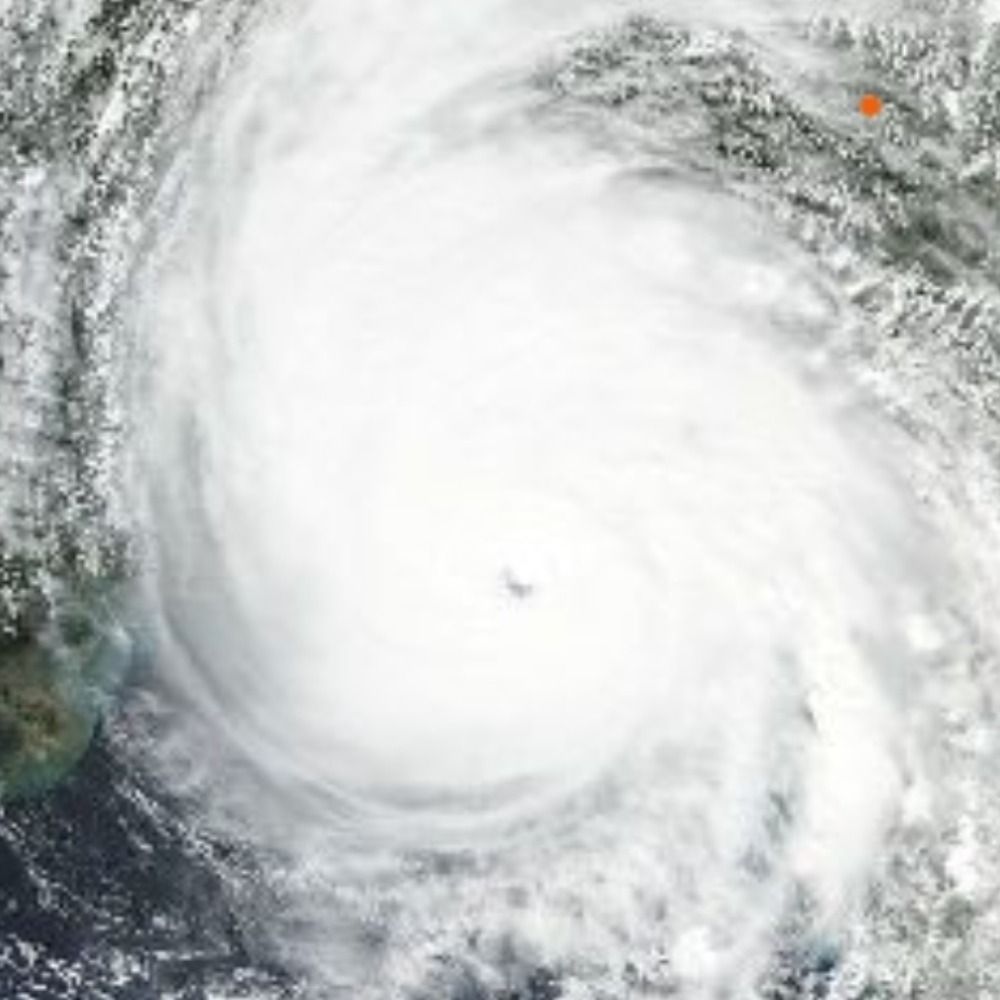
Copernicus Sentinel-2 Sat of Melissa
x.com/forecaster25...
x.com/forecaster25...

October 28, 2025 at 10:28 PM
Copernicus Sentinel-2 Sat of Melissa
x.com/forecaster25...
x.com/forecaster25...
Reposted by Michael Anderson
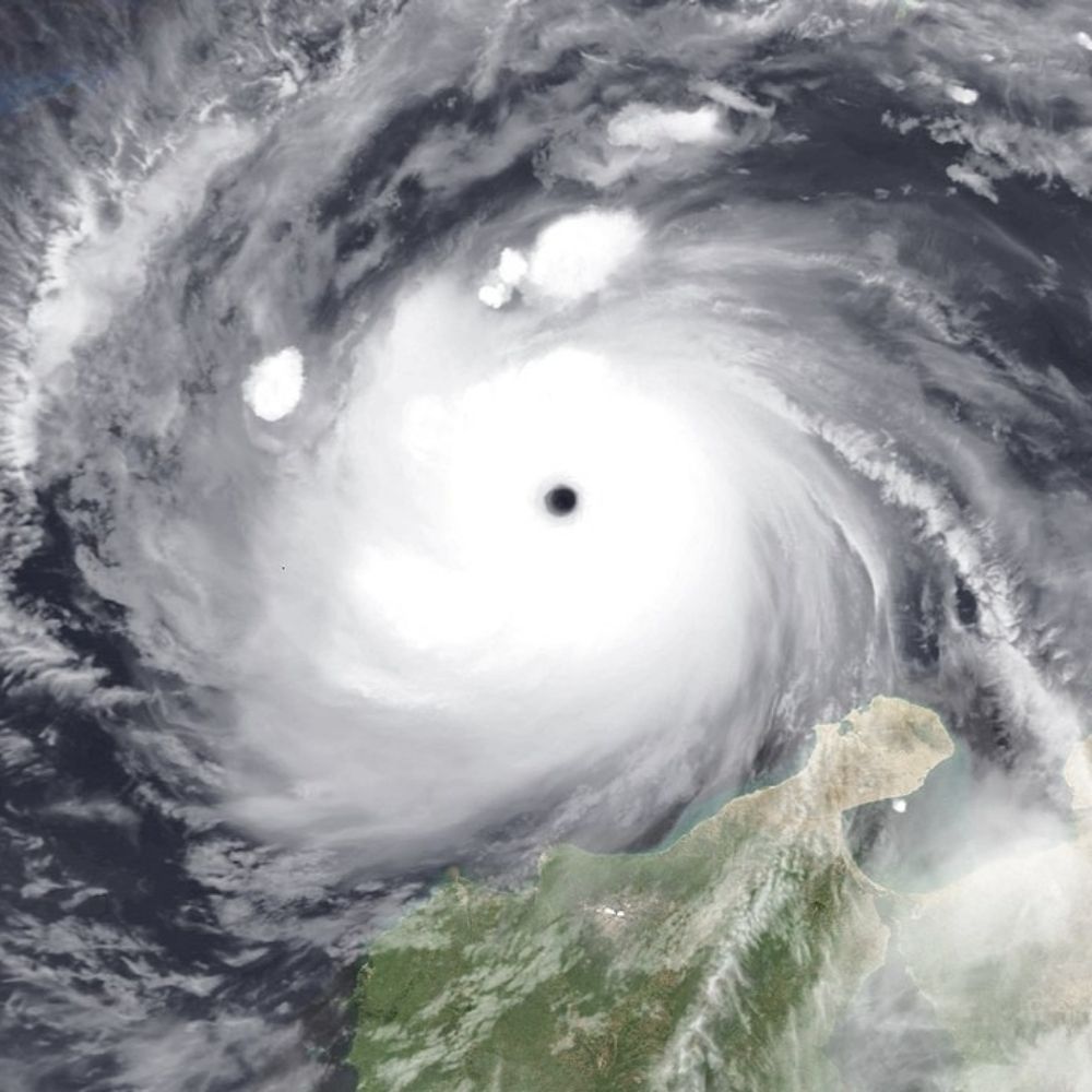
The eye of Major Hurricane Melissa has wasted no time warming again after it closed during its passage over the complex terrain of Jamaica. A nice new burst of convection in the eyewall as well. The question is how much she can re-organize and re-strengthen prior to Cuba.
October 28, 2025 at 10:48 PM
The eye of Major Hurricane Melissa has wasted no time warming again after it closed during its passage over the complex terrain of Jamaica. A nice new burst of convection in the eyewall as well. The question is how much she can re-organize and re-strengthen prior to Cuba.
Reposted by Michael Anderson

#Melissa makes landfall in southwestern Jamaica near New Hope as a powerful category 5 hurricane. For the latest updates visit hurricanes.gov


October 28, 2025 at 5:06 PM
#Melissa makes landfall in southwestern Jamaica near New Hope as a powerful category 5 hurricane. For the latest updates visit hurricanes.gov
Reposted by Michael Anderson

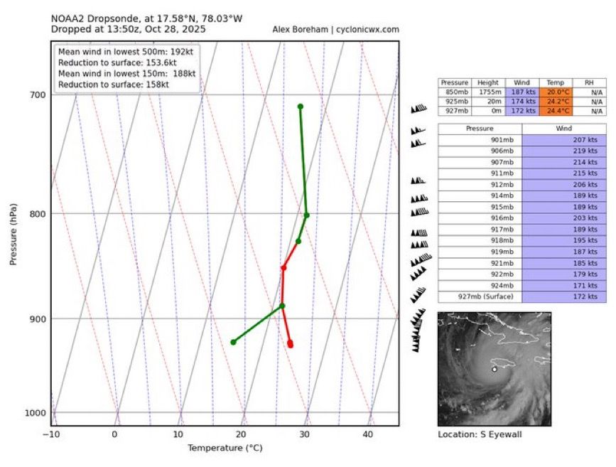
This is hands down the most extraordinary dropsonde in Atlantic recon history.

October 28, 2025 at 2:18 PM
This is hands down the most extraordinary dropsonde in Atlantic recon history.
Reposted by Michael Anderson

Wow. This is easily the most ridiculous dropsonde I’ve ever seen.
188 knot mean winds in the low-levels with gusts over 250 mph
Absolutely scary and historic hurricane headed into SW Jamaica this morning
188 knot mean winds in the low-levels with gusts over 250 mph
Absolutely scary and historic hurricane headed into SW Jamaica this morning
October 28, 2025 at 2:21 PM
Wow. This is easily the most ridiculous dropsonde I’ve ever seen.
188 knot mean winds in the low-levels with gusts over 250 mph
Absolutely scary and historic hurricane headed into SW Jamaica this morning
188 knot mean winds in the low-levels with gusts over 250 mph
Absolutely scary and historic hurricane headed into SW Jamaica this morning
Reposted by Michael Anderson
The eye of extremely powerful Major Hurricane Melissa, one of the most intense tropical cyclones ever observed in the Atlantic basin, is now imminently about to begin coming on-shore. Her powerful eyewall containing destructive winds now lashing (W) Jamaica. Terrible, absolutely terrible.
October 28, 2025 at 1:43 PM
The eye of extremely powerful Major Hurricane Melissa, one of the most intense tropical cyclones ever observed in the Atlantic basin, is now imminently about to begin coming on-shore. Her powerful eyewall containing destructive winds now lashing (W) Jamaica. Terrible, absolutely terrible.
Reposted by Michael Anderson

October 28 9:00am ET: #Melissa is now a 180 mph storm with a central pressure down to 896 millibars.
Only 5 other known Atlantic storms have had stronger wind speeds (Allen, Dorian, Wilma, Gilbert, Labor Day (1935)).
2024 & 2025: First back-to-back years with <900mb Atlantic hurricanes on record.
Only 5 other known Atlantic storms have had stronger wind speeds (Allen, Dorian, Wilma, Gilbert, Labor Day (1935)).
2024 & 2025: First back-to-back years with <900mb Atlantic hurricanes on record.
October 28, 2025 at 1:14 PM
October 28 9:00am ET: #Melissa is now a 180 mph storm with a central pressure down to 896 millibars.
Only 5 other known Atlantic storms have had stronger wind speeds (Allen, Dorian, Wilma, Gilbert, Labor Day (1935)).
2024 & 2025: First back-to-back years with <900mb Atlantic hurricanes on record.
Only 5 other known Atlantic storms have had stronger wind speeds (Allen, Dorian, Wilma, Gilbert, Labor Day (1935)).
2024 & 2025: First back-to-back years with <900mb Atlantic hurricanes on record.
Reposted by Michael Anderson

#Melissa unfortunately is still intensifying. A 9am EDT Tropical Cyclone Update indicates that winds are up to 180 mph, with an estimated minimum pressure of 896 mb.
You can see how GLM lightning has 📈 in the past hour, encircling the eye, with eye WV temp still increasing!
You can see how GLM lightning has 📈 in the past hour, encircling the eye, with eye WV temp still increasing!
October 28, 2025 at 1:13 PM
#Melissa unfortunately is still intensifying. A 9am EDT Tropical Cyclone Update indicates that winds are up to 180 mph, with an estimated minimum pressure of 896 mb.
You can see how GLM lightning has 📈 in the past hour, encircling the eye, with eye WV temp still increasing!
You can see how GLM lightning has 📈 in the past hour, encircling the eye, with eye WV temp still increasing!
Reposted by Michael Anderson

This meso loop of #Melissa from CIRA is absolutely stunning at it makes its closes in on landfall in southwestern Jamaica.
rammb-data.cira.colostate.edu/tc_realtime/...
#hurricanemelissa
rammb-data.cira.colostate.edu/tc_realtime/...
#hurricanemelissa
October 28, 2025 at 12:52 PM
This meso loop of #Melissa from CIRA is absolutely stunning at it makes its closes in on landfall in southwestern Jamaica.
rammb-data.cira.colostate.edu/tc_realtime/...
#hurricanemelissa
rammb-data.cira.colostate.edu/tc_realtime/...
#hurricanemelissa
Reposted by Michael Anderson

Here's a look at recent warming in the Caribbean during the September to November period since 1982. This is driven by human-caused climate change and fuels these powerful hurricanes. 🌊
More views at zacklabe.com/united-state...
More views at zacklabe.com/united-state...

October 28, 2025 at 1:25 PM
Here's a look at recent warming in the Caribbean during the September to November period since 1982. This is driven by human-caused climate change and fuels these powerful hurricanes. 🌊
More views at zacklabe.com/united-state...
More views at zacklabe.com/united-state...
Reposted by Michael Anderson

Waiting on a dropsonde to confirm, but Melissa is most certainly below 900 hPa right now.
Tragically we are about to witness the 2nd or 1st deepest Atlantic hurricane landfall by min MSLP on record in Jamaica.
Tragically we are about to witness the 2nd or 1st deepest Atlantic hurricane landfall by min MSLP on record in Jamaica.

October 28, 2025 at 12:41 PM
Waiting on a dropsonde to confirm, but Melissa is most certainly below 900 hPa right now.
Tragically we are about to witness the 2nd or 1st deepest Atlantic hurricane landfall by min MSLP on record in Jamaica.
Tragically we are about to witness the 2nd or 1st deepest Atlantic hurricane landfall by min MSLP on record in Jamaica.
Reposted by Michael Anderson
What we're witnessing with #Melissa is ultra rare in the history of known hurricanes in the Atlantic. This level of sustained intensity and feasting on every joule of ocean heat content without any real disruption is incredible.
Not hyperbole: Jamaica is facing a generational catastrophic event.
Not hyperbole: Jamaica is facing a generational catastrophic event.
October 28, 2025 at 2:23 AM
What we're witnessing with #Melissa is ultra rare in the history of known hurricanes in the Atlantic. This level of sustained intensity and feasting on every joule of ocean heat content without any real disruption is incredible.
Not hyperbole: Jamaica is facing a generational catastrophic event.
Not hyperbole: Jamaica is facing a generational catastrophic event.
Reposted by Michael Anderson

At 901 millibars minimum central barometric pressure, #Melissa is the strongest hurricane ever recorded so late in a season in the Atlantic. It is also the 8th strongest Atlantic #hurricane during any part of the season. It is now sadly moving north-northeast towards #Jamaica.

October 28, 2025 at 7:17 AM
At 901 millibars minimum central barometric pressure, #Melissa is the strongest hurricane ever recorded so late in a season in the Atlantic. It is also the 8th strongest Atlantic #hurricane during any part of the season. It is now sadly moving north-northeast towards #Jamaica.
Reposted by Michael Anderson
During Melissa’s rapid intensification the storm drifted slowly over exceptionally warm ocean waters that were 1.4°C (2.5°F) warmer than average — these conditions were made up to 700 times more likely because of human-caused climate change. (via @climatecentral.org) 1/2

October 28, 2025 at 12:58 AM
During Melissa’s rapid intensification the storm drifted slowly over exceptionally warm ocean waters that were 1.4°C (2.5°F) warmer than average — these conditions were made up to 700 times more likely because of human-caused climate change. (via @climatecentral.org) 1/2
Reposted by Michael Anderson
The western end of Jamaica where #Melissa is projected to make landfall has the least well-built structures of anyplace on the island. Graphic is from a 2021 paper, "Poverty and hurricane risk exposure in Jamaica": www.researchgate.net/publication/...

October 28, 2025 at 1:53 AM
The western end of Jamaica where #Melissa is projected to make landfall has the least well-built structures of anyplace on the island. Graphic is from a 2021 paper, "Poverty and hurricane risk exposure in Jamaica": www.researchgate.net/publication/...
Reposted by Michael Anderson
Hurricane #Melissa is on track to be Jamaica's strongest hurricane strike on record. Many superlatives to discuss in today's post, including a rough ride for the Hurricane Hunters: yaleclimateconnections.org/2025/10/jama...

Jamaica braces for Cat 5 Hurricane Melissa, Earth's strongest storm of 2025 » Yale Climate Connections
A remarkable three of the Atlantic's five hurricanes this year have hit Cat 5.
yaleclimateconnections.org
October 27, 2025 at 6:03 PM
Hurricane #Melissa is on track to be Jamaica's strongest hurricane strike on record. Many superlatives to discuss in today's post, including a rough ride for the Hurricane Hunters: yaleclimateconnections.org/2025/10/jama...
Reposted by Michael Anderson

From a crewmember on yesterday's Teal 74 mission into now-Category 5 Hurricane #Melissa. As clear of an eye as you will see in the Atlantic basin.
October 27, 2025 at 4:11 PM
From a crewmember on yesterday's Teal 74 mission into now-Category 5 Hurricane #Melissa. As clear of an eye as you will see in the Atlantic basin.
Reposted by Michael Anderson

🚨 None of the UN IPCC models capture what NASA satellites are seeing.
We should assume and prepare for the worst, as there is a non-zero chance of 3°C of global warming by 2050.
We better assume that it will happen and/or try to make sure that it doesn't happen.
1/
We should assume and prepare for the worst, as there is a non-zero chance of 3°C of global warming by 2050.
We better assume that it will happen and/or try to make sure that it doesn't happen.
1/
October 13, 2025 at 12:31 PM
🚨 None of the UN IPCC models capture what NASA satellites are seeing.
We should assume and prepare for the worst, as there is a non-zero chance of 3°C of global warming by 2050.
We better assume that it will happen and/or try to make sure that it doesn't happen.
1/
We should assume and prepare for the worst, as there is a non-zero chance of 3°C of global warming by 2050.
We better assume that it will happen and/or try to make sure that it doesn't happen.
1/