


@sausiuswx.bsky.social
Average weather enthusiast -
Main areas of interest: Tropical Cyclones and (European) severewx
Main areas of interest: Tropical Cyclones and (European) severewx
Fresh off the presses: Tropical Cyclone Gezani swirling menacingly close to the Mozambique coast as pictured by the MODIS instrument aboard NASA's Terra satellite


February 13, 2026 at 8:41 PM
Fresh off the presses: Tropical Cyclone Gezani swirling menacingly close to the Mozambique coast as pictured by the MODIS instrument aboard NASA's Terra satellite
Tropical Cyclone Gezani is now making its closest approach to the Mozambique coast, the eyewall coming preceriously close to shore. The eye has warmed considerably in the last few hours but the effects of shear and dry air are still evident. Intensity officially around 165 km/h
February 13, 2026 at 7:44 PM
Tropical Cyclone Gezani is now making its closest approach to the Mozambique coast, the eyewall coming preceriously close to shore. The eye has warmed considerably in the last few hours but the effects of shear and dry air are still evident. Intensity officially around 165 km/h
Throughout this morning JPSS satellites pictured Tropical Cyclone Gezani multiple times in stunning clarity, as it recovered from the adverse effects of vertical wind shear that had plagued the system overnight.


February 13, 2026 at 2:27 PM
Throughout this morning JPSS satellites pictured Tropical Cyclone Gezani multiple times in stunning clarity, as it recovered from the adverse effects of vertical wind shear that had plagued the system overnight.
Thankfully Tropical Cyclone Gezani will stay off of the Mozambique coast. That being said, tropical storm force winds and some heavy rain are still propably being felt along the caost of Inhambane Province but the core windfield should stay off-shore, which is good news.
February 13, 2026 at 1:38 PM
Thankfully Tropical Cyclone Gezani will stay off of the Mozambique coast. That being said, tropical storm force winds and some heavy rain are still propably being felt along the caost of Inhambane Province but the core windfield should stay off-shore, which is good news.
Overnight the satellite presentation of Gezani deteriorated significantly. This was almost certainly a result of the system being pummeled by shear peaking at around 15-20 knots. Now that shear is back below 10 knots, Gezani is back on the mend again.
February 13, 2026 at 10:47 AM
Overnight the satellite presentation of Gezani deteriorated significantly. This was almost certainly a result of the system being pummeled by shear peaking at around 15-20 knots. Now that shear is back below 10 knots, Gezani is back on the mend again.
Earlier today, NASA's polar orbiting satellite captured these high-resolution images of Tropical Cyclone Gezani as it was rapidly intensifying in the Mozambique channel.


February 12, 2026 at 8:23 PM
Earlier today, NASA's polar orbiting satellite captured these high-resolution images of Tropical Cyclone Gezani as it was rapidly intensifying in the Mozambique channel.
Synthetic aperture radar data yielded estimated 1 minute sustained wind speeds of 92 knots for Gezani at 1552 UTC, which aligns well with the estimates provided by the Deep Learning/AI enhanced objective intensity guides D-PRINT and AiDT. ADTs playing catchup.


February 12, 2026 at 6:34 PM
Synthetic aperture radar data yielded estimated 1 minute sustained wind speeds of 92 knots for Gezani at 1552 UTC, which aligns well with the estimates provided by the Deep Learning/AI enhanced objective intensity guides D-PRINT and AiDT. ADTs playing catchup.
Ok, I may have jinxed it slightly (god I guess). Clearly that shear that I mentioned impinging on Gezani did a bit more damage then I thought it would. Probably also lead to Gezani being ventilated with some drier more stable air. Anyway, new VHT just went up, let's see.
February 12, 2026 at 5:40 PM
Ok, I may have jinxed it slightly (god I guess). Clearly that shear that I mentioned impinging on Gezani did a bit more damage then I thought it would. Probably also lead to Gezani being ventilated with some drier more stable air. Anyway, new VHT just went up, let's see.
OMG Gezani is cooking so incredibly hard rn and undergoing an impressive period of rapid intensification. At one point I counted at least triple rotating VHTs. I am also noting cirrus fanning out into 3/4 quadrants. Tho it also evident that some shear is impinging on the vortex.
February 12, 2026 at 3:30 PM
OMG Gezani is cooking so incredibly hard rn and undergoing an impressive period of rapid intensification. At one point I counted at least triple rotating VHTs. I am also noting cirrus fanning out into 3/4 quadrants. Tho it also evident that some shear is impinging on the vortex.
Woah there. I was afraid this is gonna happen. Gezani is once again rapidly intensifiyng and is likely to once again reach the stage of Intense Tropical Cyclone. Hopefully it will not make a second landfall in Inhambane province but this scenario cannot be ruled out.
February 12, 2026 at 1:43 PM
Woah there. I was afraid this is gonna happen. Gezani is once again rapidly intensifiyng and is likely to once again reach the stage of Intense Tropical Cyclone. Hopefully it will not make a second landfall in Inhambane province but this scenario cannot be ruled out.
Cyclone Gezani is back over water and trying to re-organize. Model guidance is generally agreement that it will re-intensify but there is considerable disagreement as to how much intensification. Track is also questionable with a possible second landfall in Nampula Province.


February 11, 2026 at 9:55 PM
Cyclone Gezani is back over water and trying to re-organize. Model guidance is generally agreement that it will re-intensify but there is considerable disagreement as to how much intensification. Track is also questionable with a possible second landfall in Nampula Province.
VWP hodographs from southwestern France indicate that exstreme shear magnitudes are already in place. In fact both Momuy and Bourdeux show a 0-3 BWD of between 60 and 70 knots. Bourdeux also has a large looping hodograph. Proper convective initiation may be imminent as well.


February 11, 2026 at 6:07 PM
VWP hodographs from southwestern France indicate that exstreme shear magnitudes are already in place. In fact both Momuy and Bourdeux show a 0-3 BWD of between 60 and 70 knots. Bourdeux also has a large looping hodograph. Proper convective initiation may be imminent as well.
These high-res satellite images of Tropical Cyclone Gezani where captured less then 6 hours before its devestating landfall on the important Port City of Toamasina that has left at least 20 people dead. At virtually this exact time JTWC fixed the intensity at 205 km/h (125 mph).


February 11, 2026 at 4:21 PM
These high-res satellite images of Tropical Cyclone Gezani where captured less then 6 hours before its devestating landfall on the important Port City of Toamasina that has left at least 20 people dead. At virtually this exact time JTWC fixed the intensity at 205 km/h (125 mph).
Certainly looks like Storm Nils will also be associated with a severe weather threat especially across southern France, where extreme shear magnitudes should overlap with at least some instability. Damaging wind gusts near showers/storms and even tornadoes a possibility.


February 10, 2026 at 7:44 PM
Certainly looks like Storm Nils will also be associated with a severe weather threat especially across southern France, where extreme shear magnitudes should overlap with at least some instability. Damaging wind gusts near showers/storms and even tornadoes a possibility.
According to my analysis Intense Tropical Cyclone Gezani has just made landfall, unfortunately pretty much right on top of the port city of Toamasina. Satellite estimates suggest Gezani was a C4 SSHWS with winds of ~220 km/h at landfall. The reasonable worst case has sadly come true.
February 10, 2026 at 5:11 PM
According to my analysis Intense Tropical Cyclone Gezani has just made landfall, unfortunately pretty much right on top of the port city of Toamasina. Satellite estimates suggest Gezani was a C4 SSHWS with winds of ~220 km/h at landfall. The reasonable worst case has sadly come true.
According to my analysis Intense Tropical Cyclone Gezani has just made landfall unfortunately virtually on top of the port city of Toamasina. Satellite estimates suggest Gezani was a Cat 4 SSHWS with winds of ~220 km/h at landfall. The reasonable worst case has sadly come true.
February 10, 2026 at 5:08 PM
According to my analysis Intense Tropical Cyclone Gezani has just made landfall unfortunately virtually on top of the port city of Toamasina. Satellite estimates suggest Gezani was a Cat 4 SSHWS with winds of ~220 km/h at landfall. The reasonable worst case has sadly come true.
Recently received high-res MW images confirm that Gezani continues well along the path of core formation. A nascent core is clerly present, with only a weakness in the SE quad ramaining. Also note the presence of a cyan ring at 37 Ghz, which often heralds rapid intensification.


February 9, 2026 at 5:22 PM
Recently received high-res MW images confirm that Gezani continues well along the path of core formation. A nascent core is clerly present, with only a weakness in the SE quad ramaining. Also note the presence of a cyan ring at 37 Ghz, which often heralds rapid intensification.
Based on agency and model forecasts it is becoming increasingly likely that Gezani will deliver a direct hit to the important port city of Toamasina, home to >300k people, as a very dangerous Intense Tropical Cyclone within just 24 hours. THIS IS A LIFE-THREATENING SITUATION!


February 9, 2026 at 3:14 PM
Based on agency and model forecasts it is becoming increasingly likely that Gezani will deliver a direct hit to the important port city of Toamasina, home to >300k people, as a very dangerous Intense Tropical Cyclone within just 24 hours. THIS IS A LIFE-THREATENING SITUATION!
Gezani looks rather healthy today north of Reunion. Rotating convective bursts indicate that core formation is in progress and MW images back this up. Forming CDO looks relatively symmetrical. All points to a healthy system that is at least steadily strengthening.
February 9, 2026 at 2:46 PM
Gezani looks rather healthy today north of Reunion. Rotating convective bursts indicate that core formation is in progress and MW images back this up. Forming CDO looks relatively symmetrical. All points to a healthy system that is at least steadily strengthening.
Actually getting concerned again about Gezani after thinking the last few days that it isn't a big problem afterall. Some of the newer guidance is very bullish again. Low shear and a favourable upper-level pattern could allow an intense tropical cyclone landfall in Madagascar.


February 8, 2026 at 8:54 PM
Actually getting concerned again about Gezani after thinking the last few days that it isn't a big problem afterall. Some of the newer guidance is very bullish again. Low shear and a favourable upper-level pattern could allow an intense tropical cyclone landfall in Madagascar.
Well, turns out that Mitchell has actually stayed towards the western end of the guidance envelope and is now in the process of rounding northwest cape. Despite having lost much of its intensity at this point, damaging winds are still possibly overspraeding part of the peninsula.
February 8, 2026 at 4:23 PM
Well, turns out that Mitchell has actually stayed towards the western end of the guidance envelope and is now in the process of rounding northwest cape. Despite having lost much of its intensity at this point, damaging winds are still possibly overspraeding part of the peninsula.
Cyclone Mitchell is struggling with the effects of shear as it starts to near landfall in the Exmouth gulf in about 18 hours. This manifests in only a partial eyewall being present on the downshear right. BOM estimates C3 on Aus scale. Expected to bring damaging winds to Onslow this afternoon.


February 7, 2026 at 8:02 PM
Cyclone Mitchell is struggling with the effects of shear as it starts to near landfall in the Exmouth gulf in about 18 hours. This manifests in only a partial eyewall being present on the downshear right. BOM estimates C3 on Aus scale. Expected to bring damaging winds to Onslow this afternoon.
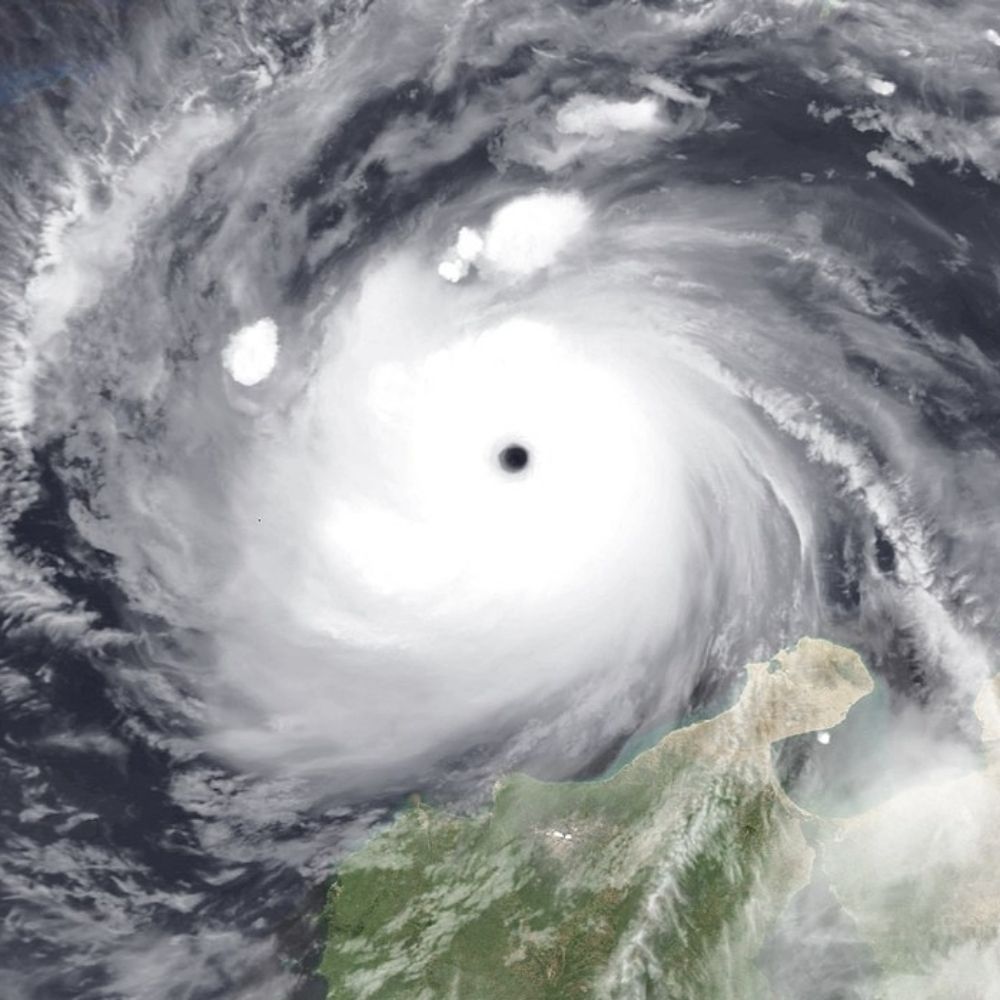
Eearlier this afternoon, the polar orbiting Aqua satellite captured these images of windstorm Marta approaching Portugal. Less then two weeks after areas just a bit further south were devestated by historic windstorm Kirstin. Hoping for a less serious outcome this time. (1/3)


February 7, 2026 at 5:37 PM
Eearlier this afternoon, the polar orbiting Aqua satellite captured these images of windstorm Marta approaching Portugal. Less then two weeks after areas just a bit further south were devestated by historic windstorm Kirstin. Hoping for a less serious outcome this time. (1/3)
I don't like what I am seeing from the ICON-EU at all regarding storm Marta tomorrow. For several runs now, ICON-EU has been very bullish & a northward trend has it now progging damaging hurricane-force gusts in the Porto vicinity. Other solutions more bearish tho🤞


February 6, 2026 at 9:26 PM
I don't like what I am seeing from the ICON-EU at all regarding storm Marta tomorrow. For several runs now, ICON-EU has been very bullish & a northward trend has it now progging damaging hurricane-force gusts in the Porto vicinity. Other solutions more bearish tho🤞
One thing to watch out for with Mitchell is that due to the storm hugging the Pilbara coast its entire life, it is very much possible that it brings hurricane-force winds to Karratha. despite an actual landfall near Onslow. The latest HAFS-A depicts this possibility quite well.
February 6, 2026 at 7:47 PM
One thing to watch out for with Mitchell is that due to the storm hugging the Pilbara coast its entire life, it is very much possible that it brings hurricane-force winds to Karratha. despite an actual landfall near Onslow. The latest HAFS-A depicts this possibility quite well.