


Alex Melendez
@kzoowxman.bsky.social
Studied Meteorology at Central Michigan University. B.A. in Communications. Treasurer/Forecaster for Michigan Storm Chasers. Go Blue! Rep Detroit. One Pride.
Reposted by Alex Melendez

PETERS: Will you commit to me that the forecasting office in Marquette will not cease its round the clock operation?
LUTNICK: You don't understand it yet because nobody has explained it to you. These are hard drive computers literally that nobody has seen in 25 years
PETERS: So the answer is no
LUTNICK: You don't understand it yet because nobody has explained it to you. These are hard drive computers literally that nobody has seen in 25 years
PETERS: So the answer is no
June 4, 2025 at 3:52 PM
PETERS: Will you commit to me that the forecasting office in Marquette will not cease its round the clock operation?
LUTNICK: You don't understand it yet because nobody has explained it to you. These are hard drive computers literally that nobody has seen in 25 years
PETERS: So the answer is no
LUTNICK: You don't understand it yet because nobody has explained it to you. These are hard drive computers literally that nobody has seen in 25 years
PETERS: So the answer is no
Reposted by Alex Melendez

Reposted by Alex Melendez

Tropical Cyclone #Alfred is slowly strengthening in the Coral Sea.
Currently well offshore from north Queensland, Alfred is expected to turn southeast and intensify midweek. While its future path remains uncertain, it could approach the Queensland coast over the coming days.
Currently well offshore from north Queensland, Alfred is expected to turn southeast and intensify midweek. While its future path remains uncertain, it could approach the Queensland coast over the coming days.
February 24, 2025 at 10:52 AM
Tropical Cyclone #Alfred is slowly strengthening in the Coral Sea.
Currently well offshore from north Queensland, Alfred is expected to turn southeast and intensify midweek. While its future path remains uncertain, it could approach the Queensland coast over the coming days.
Currently well offshore from north Queensland, Alfred is expected to turn southeast and intensify midweek. While its future path remains uncertain, it could approach the Queensland coast over the coming days.
Reposted by Alex Melendez
More of this is going on

February 18, 2025 at 6:34 PM
More of this is going on
Reposted by Alex Melendez

[Delayed Report] On Dec 4, at 6:53 PM EST, 3 E South Haven [Van Buren Co, MI] Public reports Non-Tstm Wnd Dmg. Four trees down on one property with trunk snaps and uproots. One tree landed on a camper trailer. #miwx Link

December 6, 2024 at 3:59 PM
[Delayed Report] On Dec 4, at 6:53 PM EST, 3 E South Haven [Van Buren Co, MI] Public reports Non-Tstm Wnd Dmg. Four trees down on one property with trunk snaps and uproots. One tree landed on a camper trailer. #miwx Link
Reposted by Alex Melendez

BREAKING NEWS: A powerful 7.0 earthquake has struck off the northern California coast. A tsunami warning has been issued.
The tsunami warning stretches hundreds of miles from the Bay Area of California north into central Oregon.
The tsunami warning stretches hundreds of miles from the Bay Area of California north into central Oregon.

A powerful 7.0 earthquake strikes off northern California coast; tsunami warning issued
A powerful earthquake has struck off the northern California coast and a tsunami warning has been issued. Several aftershocks continue to rattle the area off Eureka.
www.npr.org
December 5, 2024 at 7:35 PM
BREAKING NEWS: A powerful 7.0 earthquake has struck off the northern California coast. A tsunami warning has been issued.
The tsunami warning stretches hundreds of miles from the Bay Area of California north into central Oregon.
The tsunami warning stretches hundreds of miles from the Bay Area of California north into central Oregon.
Snow squalls are coming. Lake effect to follow overnight.

December 4, 2024 at 11:28 PM
Snow squalls are coming. Lake effect to follow overnight.
Another winter storm comes. After digging out from the first blast of lake effect, another round comes in tomorrow night and Thursday. Very strong winds accompany this.


December 3, 2024 at 8:01 PM
Another winter storm comes. After digging out from the first blast of lake effect, another round comes in tomorrow night and Thursday. Very strong winds accompany this.
Reposted by Alex Melendez

6 years ago this evening near Beardstown, Illinois - one of ~5 tornadoes I observed during the December 1st, 2018 tornado outbreak - none more photogenic than this one.
The calendar said climatological winter but forecast soundings said classic supercells.
The calendar said climatological winter but forecast soundings said classic supercells.

December 2, 2024 at 1:41 AM
6 years ago this evening near Beardstown, Illinois - one of ~5 tornadoes I observed during the December 1st, 2018 tornado outbreak - none more photogenic than this one.
The calendar said climatological winter but forecast soundings said classic supercells.
The calendar said climatological winter but forecast soundings said classic supercells.
Reposted by Alex Melendez

Tampa Bay has work to do: 126 flood pumps and 40 sewage lift stations malfunctioned or lost power during Milton, putting over 20 million gallons of sewage into Tampa Bay. A recommendation: Solar power generators!
www.tampabay.com/news/hillsbo...
www.tampabay.com/news/hillsbo...

Two hurricanes swamped Tampa Bay flood defenses. What can be done?
Sewage stations backed up. Drainage systems were overwhelmed. But experts say there are upgrades possible to prevent flooding in the future.
www.tampabay.com
December 2, 2024 at 1:02 AM
Tampa Bay has work to do: 126 flood pumps and 40 sewage lift stations malfunctioned or lost power during Milton, putting over 20 million gallons of sewage into Tampa Bay. A recommendation: Solar power generators!
www.tampabay.com/news/hillsbo...
www.tampabay.com/news/hillsbo...
Reposted by Alex Melendez
( #BuffaloBills ): #Timelapse of the clearing of around 2 FEET of Lake Effect #SNOW at Orchard Park #NewYork ( #NYwx ) stadium near Buffalo Sunday afternoon (December 1) ahead of the #NFL game Sunday night #wx #wxsky
Ready. For. #Football.
#SFvsBUF | #BillsMafia
Ready. For. #Football.
#SFvsBUF | #BillsMafia
December 2, 2024 at 12:54 AM
( #BuffaloBills ): #Timelapse of the clearing of around 2 FEET of Lake Effect #SNOW at Orchard Park #NewYork ( #NYwx ) stadium near Buffalo Sunday afternoon (December 1) ahead of the #NFL game Sunday night #wx #wxsky
Ready. For. #Football.
#SFvsBUF | #BillsMafia
Ready. For. #Football.
#SFvsBUF | #BillsMafia
Next round up. Winter Storm Watches for the West Michigan lakeshore, Winter Storm Warnings for the U.P. and northern lower Michigan. HREF still depicting significant totals by Monday evening, another foot of snow for some.

December 1, 2024 at 7:16 PM
Next round up. Winter Storm Watches for the West Michigan lakeshore, Winter Storm Warnings for the U.P. and northern lower Michigan. HREF still depicting significant totals by Monday evening, another foot of snow for some.
Reposted by Alex Melendez

That is some convective lake effect snow coming off Lake Ontario into the Tug Hill. Whew. Not quite megaband status yet but not far off.
November 30, 2024 at 2:44 AM
That is some convective lake effect snow coming off Lake Ontario into the Tug Hill. Whew. Not quite megaband status yet but not far off.
Reposted by Alex Melendez

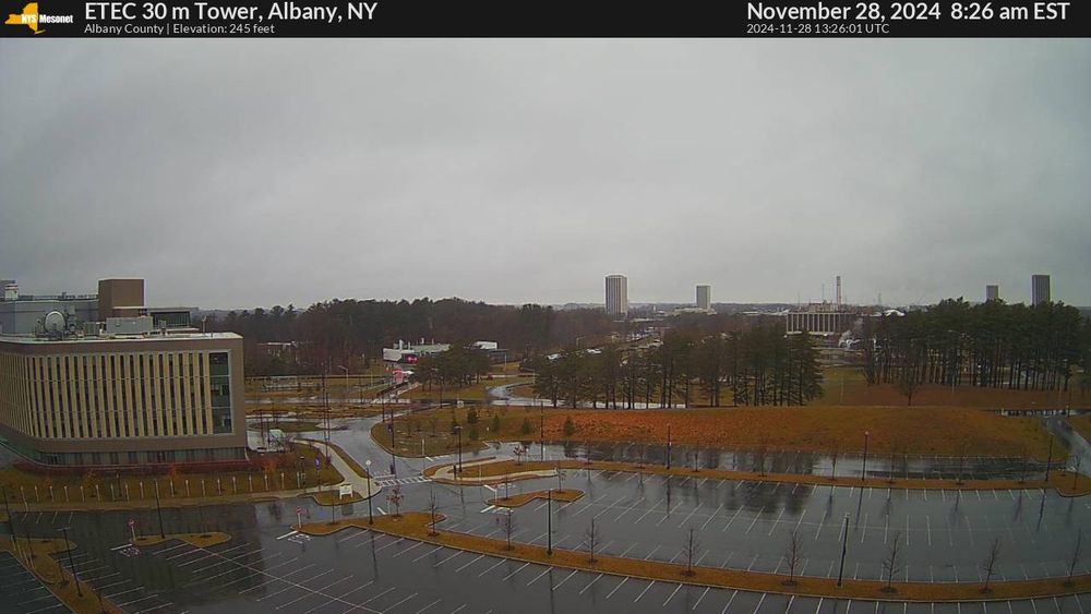
Just a bit of elevation difference making a big difference for snow accumulations in the Albany area. NYSM camera images at Voorheesville (375 ft elevation) vs UAlbany (250 ft):

November 28, 2024 at 3:03 PM
Just a bit of elevation difference making a big difference for snow accumulations in the Albany area. NYSM camera images at Voorheesville (375 ft elevation) vs UAlbany (250 ft):
Reposted by Alex Melendez

The ultimate chasecation trip planner plot. Based on 2,000 documented Great Plains supercells and tornadoes since 1990, and sans inflation of multi-storm outbreaks, here's just the likelihood that each day gives you a storm:

November 27, 2024 at 11:41 PM
The ultimate chasecation trip planner plot. Based on 2,000 documented Great Plains supercells and tornadoes since 1990, and sans inflation of multi-storm outbreaks, here's just the likelihood that each day gives you a storm:
Reposted by Alex Melendez

Light(n)ing the Way.
![A colorful supercell thunderstorm hovers directly over the road ahead. A lightning bolt strikes right over the road - its light reflects off of the wet pavement, illuminating the foreground, and reveals details in the cloud structure. On the left of the storm is a clear blue night sky full of stars. [P.S. to my storm chaser friends from Twitter...I am sorry. You already saw enough of this storm, but I am still getting through them here. Just mute 'Ada' or me].](https://cdn.bsky.app/img/feed_thumbnail/plain/did:plc:acm2yz57z6weqbdbw5lpluu3/bafkreibhiv4neyzfqp332dtait3gw4e6jblp5ddf7cufw6wtenjnvpdcdm@jpeg)
November 27, 2024 at 11:06 PM
Light(n)ing the Way.
Reposted by Alex Melendez

If ∂T/∂t is calculated using multiple output times, then the 1st law of thermo can be used to back out the diabatic contribution


November 27, 2024 at 9:36 PM
If ∂T/∂t is calculated using multiple output times, then the 1st law of thermo can be used to back out the diabatic contribution
While we don't have a presence yet on Blue Sky, Michigan Storm Chasers released our snowfall totals for the multi day Lake Effect event from overnight Thursday through Tuesday.

November 27, 2024 at 11:19 PM
While we don't have a presence yet on Blue Sky, Michigan Storm Chasers released our snowfall totals for the multi day Lake Effect event from overnight Thursday through Tuesday.
18z Euro continues the Lake Effect madness, 12z had strong support from ensembles, so far, 18z ensembles contunue support.


November 27, 2024 at 12:33 AM
18z Euro continues the Lake Effect madness, 12z had strong support from ensembles, so far, 18z ensembles contunue support.
Reposted by Alex Melendez

So much pain in the extended outlook for Alaska. Everything after day 6 or 7 is incredibly warm and there is no end in sight. It will be a brutal first half of December around here. This map shows the probability of being 10F above normal on Dec 6th. @alaskawx.bsky.social

November 26, 2024 at 10:04 PM
So much pain in the extended outlook for Alaska. Everything after day 6 or 7 is incredibly warm and there is no end in sight. It will be a brutal first half of December around here. This map shows the probability of being 10F above normal on Dec 6th. @alaskawx.bsky.social
Reposted by Alex Melendez
Ahhhhh I passed my phd preliminary exams lets go
November 26, 2024 at 6:58 PM
Ahhhhh I passed my phd preliminary exams lets go
Reposted by Alex Melendez
November 25-29th, 1921:
New England was in the midst of a four-day ice storm. Following the storm, ice was more than three inches thick in many places, and property damage was in the millions of dollars. Northern New England received heavy snow, with more than two feet reported in some areas.
New England was in the midst of a four-day ice storm. Following the storm, ice was more than three inches thick in many places, and property damage was in the millions of dollars. Northern New England received heavy snow, with more than two feet reported in some areas.


November 26, 2024 at 1:07 PM
November 25-29th, 1921:
New England was in the midst of a four-day ice storm. Following the storm, ice was more than three inches thick in many places, and property damage was in the millions of dollars. Northern New England received heavy snow, with more than two feet reported in some areas.
New England was in the midst of a four-day ice storm. Following the storm, ice was more than three inches thick in many places, and property damage was in the millions of dollars. Northern New England received heavy snow, with more than two feet reported in some areas.
Reposted by Alex Melendez


Who wants a white Thanksgiving? This guy. Euro ensemble average creeping north.

November 23, 2024 at 8:14 PM
Who wants a white Thanksgiving? This guy. Euro ensemble average creeping north.
Reposted by Alex Melendez

How has your 2024 been when it comes to NWS Storm Prediction Center outlooks? Here are the spots that have seen at least one of the four major categories (or higher) up through today.


November 20, 2024 at 11:30 PM
How has your 2024 been when it comes to NWS Storm Prediction Center outlooks? Here are the spots that have seen at least one of the four major categories (or higher) up through today.