


Da'Vel Johnson
@davelrj.bsky.social
NOLA Native. Meteorologist with an interest in economics and decision making. I stay active, do capoeira, work on my French and Spanish. Nature Photography too. Don't worry. Be Happy ⚜️ linktr.ee/davelrj
After Monday's cold front, DC and the Northeast won't see 45 degrees for quite some time. 👎🏾
December 27, 2025 at 1:28 PM
After Monday's cold front, DC and the Northeast won't see 45 degrees for quite some time. 👎🏾
Reposted by Da'Vel Johnson

Expected impacts from this weekend's major SoCal storm--which now appears likely to feature widespread flood risk and also a few severe thunderstorms--continue to increase. I will have a blog post and YouTube livestream at a TBD time later today to discuss. #CAwx

November 14, 2025 at 5:39 PM
Expected impacts from this weekend's major SoCal storm--which now appears likely to feature widespread flood risk and also a few severe thunderstorms--continue to increase. I will have a blog post and YouTube livestream at a TBD time later today to discuss. #CAwx
Clear sky and a full moon

November 5, 2025 at 3:46 AM
Clear sky and a full moon
Reposted by Da'Vel Johnson

Nighttime polar orbiter satellite photos of Jamaica before and after #Melissa show how the power grid was affected. Melissa knocked out power to about 77% of Jamaica’s customers, said Minister of Local Government Desmond McKenzie. Photos from worldview.earthdata.nasa.gov

October 30, 2025 at 2:16 PM
Nighttime polar orbiter satellite photos of Jamaica before and after #Melissa show how the power grid was affected. Melissa knocked out power to about 77% of Jamaica’s customers, said Minister of Local Government Desmond McKenzie. Photos from worldview.earthdata.nasa.gov
Reposted by Da'Vel Johnson

“Once we arrived in central Jamaica we started to see how severely the island has been hit. The town of Mandeville has been, for want of a better word, flattened. A petrol station had lost its roof and most of its pumps.”
www.bbc.com/news/article...
www.bbc.com/news/article...

Jamaicans take stock after Hurricane Melissa causes damage, flooding and power cuts
With communication networks in Jamaica crippled, the true scale of the disaster remains unknown.
www.bbc.com
October 30, 2025 at 9:31 AM
“Once we arrived in central Jamaica we started to see how severely the island has been hit. The town of Mandeville has been, for want of a better word, flattened. A petrol station had lost its roof and most of its pumps.”
www.bbc.com/news/article...
www.bbc.com/news/article...
The satellite derived wind field really puts the scale into prospective. Around half the Jamaica will see hurricane force winds from Melissa, but several parishes (Westmoreland, Saint Elizabeth, Manchester, Saint James, Trelawny) will see extreme winds over 95kts/110 mph. Higher in the mountains.

October 28, 2025 at 2:24 PM
The satellite derived wind field really puts the scale into prospective. Around half the Jamaica will see hurricane force winds from Melissa, but several parishes (Westmoreland, Saint Elizabeth, Manchester, Saint James, Trelawny) will see extreme winds over 95kts/110 mph. Higher in the mountains.
Reposted by Da'Vel Johnson

#Melissa unfortunately is still intensifying. A 9am EDT Tropical Cyclone Update indicates that winds are up to 180 mph, with an estimated minimum pressure of 896 mb.
You can see how GLM lightning has 📈 in the past hour, encircling the eye, with eye WV temp still increasing!
You can see how GLM lightning has 📈 in the past hour, encircling the eye, with eye WV temp still increasing!
October 28, 2025 at 1:13 PM
#Melissa unfortunately is still intensifying. A 9am EDT Tropical Cyclone Update indicates that winds are up to 180 mph, with an estimated minimum pressure of 896 mb.
You can see how GLM lightning has 📈 in the past hour, encircling the eye, with eye WV temp still increasing!
You can see how GLM lightning has 📈 in the past hour, encircling the eye, with eye WV temp still increasing!
Reposted by Da'Vel Johnson

Waiting on a dropsonde to confirm, but Melissa is most certainly below 900 hPa right now.
Tragically we are about to witness the 2nd or 1st deepest Atlantic hurricane landfall by min MSLP on record in Jamaica.
Tragically we are about to witness the 2nd or 1st deepest Atlantic hurricane landfall by min MSLP on record in Jamaica.

October 28, 2025 at 12:41 PM
Waiting on a dropsonde to confirm, but Melissa is most certainly below 900 hPa right now.
Tragically we are about to witness the 2nd or 1st deepest Atlantic hurricane landfall by min MSLP on record in Jamaica.
Tragically we are about to witness the 2nd or 1st deepest Atlantic hurricane landfall by min MSLP on record in Jamaica.
Reposted by Da'Vel Johnson
The western end of Jamaica where #Melissa is projected to make landfall has the least well-built structures of anyplace on the island. Graphic is from a 2021 paper, "Poverty and hurricane risk exposure in Jamaica": www.researchgate.net/publication/...

October 28, 2025 at 1:53 AM
The western end of Jamaica where #Melissa is projected to make landfall has the least well-built structures of anyplace on the island. Graphic is from a 2021 paper, "Poverty and hurricane risk exposure in Jamaica": www.researchgate.net/publication/...
Reposted by Da'Vel Johnson

What we're witnessing with #Melissa is ultra rare in the history of known hurricanes in the Atlantic. This level of sustained intensity and feasting on every joule of ocean heat content without any real disruption is incredible.
Not hyperbole: Jamaica is facing a generational catastrophic event.
Not hyperbole: Jamaica is facing a generational catastrophic event.
October 28, 2025 at 2:23 AM
What we're witnessing with #Melissa is ultra rare in the history of known hurricanes in the Atlantic. This level of sustained intensity and feasting on every joule of ocean heat content without any real disruption is incredible.
Not hyperbole: Jamaica is facing a generational catastrophic event.
Not hyperbole: Jamaica is facing a generational catastrophic event.
Reposted by Da'Vel Johnson

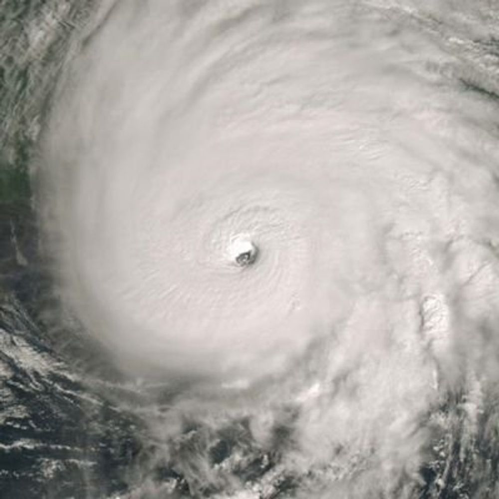
The monster eye at the center of a still strengthening Hurricane Melissa.
October 27, 2025 at 4:54 PM
The monster eye at the center of a still strengthening Hurricane Melissa.
Reposted by Da'Vel Johnson
Sunrise on Hurricane Melissa.
Melissa is now a Category 4 storm with sustained winds of 140 mph.
Melissa is now a Category 4 storm with sustained winds of 140 mph.
October 26, 2025 at 2:59 PM
Sunrise on Hurricane Melissa.
Melissa is now a Category 4 storm with sustained winds of 140 mph.
Melissa is now a Category 4 storm with sustained winds of 140 mph.
Reposted by Da'Vel Johnson

Melissa has rapidly intensified into a category 4 major hurricane according to preliminary NHC estimates:
- from 60 to 120 kt in 24 hours (⬆️ 60 kt)
- from 90 to 110 kt in just 6 hours (⬆️ 20 kt)
This slow-moving storm will not only deliver damaging winds & storm surge but also catastrophic rainfall.
- from 60 to 120 kt in 24 hours (⬆️ 60 kt)
- from 90 to 110 kt in just 6 hours (⬆️ 20 kt)
This slow-moving storm will not only deliver damaging winds & storm surge but also catastrophic rainfall.
October 26, 2025 at 1:51 PM
Melissa has rapidly intensified into a category 4 major hurricane according to preliminary NHC estimates:
- from 60 to 120 kt in 24 hours (⬆️ 60 kt)
- from 90 to 110 kt in just 6 hours (⬆️ 20 kt)
This slow-moving storm will not only deliver damaging winds & storm surge but also catastrophic rainfall.
- from 60 to 120 kt in 24 hours (⬆️ 60 kt)
- from 90 to 110 kt in just 6 hours (⬆️ 20 kt)
This slow-moving storm will not only deliver damaging winds & storm surge but also catastrophic rainfall.
Reposted by Da'Vel Johnson

Category 4 🚨
Major Hurricane Melissa
5:00 AM EDT Sun Oct 26
Location: 16.3°N 76.3°W
Moving: W at 5 mph
Min pressure: 944 mb
Max sustained: 140 mph
(image via @tropicaltidbits.bsky.social)
Major Hurricane Melissa
5:00 AM EDT Sun Oct 26
Location: 16.3°N 76.3°W
Moving: W at 5 mph
Min pressure: 944 mb
Max sustained: 140 mph
(image via @tropicaltidbits.bsky.social)
October 26, 2025 at 9:02 AM
Category 4 🚨
Major Hurricane Melissa
5:00 AM EDT Sun Oct 26
Location: 16.3°N 76.3°W
Moving: W at 5 mph
Min pressure: 944 mb
Max sustained: 140 mph
(image via @tropicaltidbits.bsky.social)
Major Hurricane Melissa
5:00 AM EDT Sun Oct 26
Location: 16.3°N 76.3°W
Moving: W at 5 mph
Min pressure: 944 mb
Max sustained: 140 mph
(image via @tropicaltidbits.bsky.social)
Reposted by Da'Vel Johnson
Recon is finding #Melissa notably stronger, at about 85kt with pressure having dropped all the way to 971mb. The wind field is much more coherent and symmetric, and there are double hot towers trying to surround the eye. Could see some impressive intensification rates from recon this evening


October 25, 2025 at 11:21 PM
Recon is finding #Melissa notably stronger, at about 85kt with pressure having dropped all the way to 971mb. The wind field is much more coherent and symmetric, and there are double hot towers trying to surround the eye. Could see some impressive intensification rates from recon this evening
Reposted by Da'Vel Johnson
Jamaica, in particular, will likely suffer catastrophic impacts from now rapidly-intensifying (but slow-moving) Hurricane #Melissa. A *Category 5* landfall now appears to be the most likely outcome, & 30-40+ inches of *additional* rain in mountains will lead to extreme flooding.

October 25, 2025 at 9:26 PM
Jamaica, in particular, will likely suffer catastrophic impacts from now rapidly-intensifying (but slow-moving) Hurricane #Melissa. A *Category 5* landfall now appears to be the most likely outcome, & 30-40+ inches of *additional* rain in mountains will lead to extreme flooding.

With the GFS coming more in-line with the rest of the model guidence this afternoon, it confirms that Tropical Storm Melissa will produce near-historic amounts of rainfall and flooding for Jamaica, Hispanola, and eastern Cuba when it makes landfall as a major hurricane.

October 25, 2025 at 4:59 PM
With the GFS coming more in-line with the rest of the model guidence this afternoon, it confirms that Tropical Storm Melissa will produce near-historic amounts of rainfall and flooding for Jamaica, Hispanola, and eastern Cuba when it makes landfall as a major hurricane.
Reposted by Da'Vel Johnson

#Melissa is about to undergo rapid intensification (RI). And I anticipate it will be quite explosive. A classic cyan ring on 37 GHz imagery from this GMI overpass at 1447 UTC.

October 25, 2025 at 4:15 PM
#Melissa is about to undergo rapid intensification (RI). And I anticipate it will be quite explosive. A classic cyan ring on 37 GHz imagery from this GMI overpass at 1447 UTC.
Reposted by Da'Vel Johnson

The current forecast at Cape May Harbor Sunday afternoon has major flooding. Uh oh.

October 10, 2025 at 2:08 PM
The current forecast at Cape May Harbor Sunday afternoon has major flooding. Uh oh.
Reposted by Da'Vel Johnson

This will be a common sight across #SaintAugustine into the weekend. Continuous periods of heavy rainfall combined with a developing Nor’easter off the coast will contribute to flooding across the area. Never drive through flooded roadways. Good news: much drier next week. #wx


October 10, 2025 at 2:35 PM
This will be a common sight across #SaintAugustine into the weekend. Continuous periods of heavy rainfall combined with a developing Nor’easter off the coast will contribute to flooding across the area. Never drive through flooded roadways. Good news: much drier next week. #wx
Reposted by Da'Vel Johnson

A textbook example of concentric eyewalls in Super Typhoon #Ragasa as seen from Chinese radars. This and other radar loops are available at bmcnoldy.earth.miami.edu/tropics/radar/.
#HuajiashaCN
#HuajiashaCN
September 23, 2025 at 12:19 PM
A textbook example of concentric eyewalls in Super Typhoon #Ragasa as seen from Chinese radars. This and other radar loops are available at bmcnoldy.earth.miami.edu/tropics/radar/.
#HuajiashaCN
#HuajiashaCN
Reposted by Da'Vel Johnson

There are a lot of NWS positions now posted on USAJobs. Come work with us! I guarantee you'll have a tough time finding public servants more passionate about the work they do. www.usajobs.gov/search/resul...
USAJOBS - Search
www.usajobs.gov
September 12, 2025 at 1:27 PM
There are a lot of NWS positions now posted on USAJobs. Come work with us! I guarantee you'll have a tough time finding public servants more passionate about the work they do. www.usajobs.gov/search/resul...
Reposted by Da'Vel Johnson

Half-baked notion, so caveats. But if LLMs are basically trained on our collective work without permission or consent and then used to routinize much of that work, a large share of the capital gains should go to a national fund dividend, analogous to the Alaska Fund, that pays us all.
September 9, 2025 at 3:21 PM
Half-baked notion, so caveats. But if LLMs are basically trained on our collective work without permission or consent and then used to routinize much of that work, a large share of the capital gains should go to a national fund dividend, analogous to the Alaska Fund, that pays us all.
⛈️⛈️⛈️

We asked Americans about 16 federal agencies. The National Park Service and National Weather Service were among the most favorable. www.pewresearch.org/...

September 4, 2025 at 4:37 PM
⛈️⛈️⛈️