


Dr. Athena Masson
@weathergoddess.bsky.social
Meteorologist & Hurricane specialist. Creator of the Masson-Gough Hurricane Scale. UofT PhD Graduate. JU MBA. I collect degrees. Researcher and Professor 🎓Not a “Weather Girl”
Cold Weather Advisory in place for much of Northeast #Florida. Not everyday that we see wind chill values in the lower 20s, especially in November. Even wording of hypothermia & frostbite. Bring in all pets and sensitive plants tonight. Gradual warming expected after Tuesday. #wx

November 11, 2025 at 12:24 AM
Coldest temps of the season arrive Monday & Tuesday for parts of North #Florida. Cold front moving through tonight with high pressure building in behind bringing cold northerly winds. Freeze Watch in place for Monday night & into Tuesday morning. Bring in pets & sensitive plants.

November 10, 2025 at 2:47 AM
Coldest temps of the season arrive Monday & Tuesday for parts of North #Florida. Cold front moving through tonight with high pressure building in behind bringing cold northerly winds. Freeze Watch in place for Monday night & into Tuesday morning. Bring in pets & sensitive plants.
Seven years later and I am still rocking my #hurricane graduation shoes. #wx


November 7, 2025 at 11:50 PM
Seven years later and I am still rocking my #hurricane graduation shoes. #wx
It’s not #Halloween without the annual #hurricane pumpkin. Focused on the stadium effect for the eye this year. Have a Happy Halloween everyone 🌀

November 1, 2025 at 2:19 AM
It’s not #Halloween without the annual #hurricane pumpkin. Focused on the stadium effect for the eye this year. Have a Happy Halloween everyone 🌀
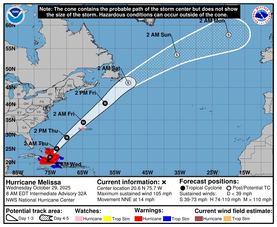
Eyes on The Bahamas today. However, #Bermuda now under a #Hurricane Warning. #Melissa will be picked up by a cold front from the north pushing it towards Bermuda Thursday. A chance of intensification but strong wind shear and the cold front interaction could hinder strengthening.


October 29, 2025 at 5:48 PM
Eyes on The Bahamas today. However, #Bermuda now under a #Hurricane Warning. #Melissa will be picked up by a cold front from the north pushing it towards Bermuda Thursday. A chance of intensification but strong wind shear and the cold front interaction could hinder strengthening.
#Melissa pulling away from #Cuba & approaching The Bahamas. Currently a Category 2. Land interaction has helped to weaken the winds but heavy rainfall, flooding, & surge will persist across the region today. Don’t focus on the Category, focus on protecting your life and property.


October 29, 2025 at 2:42 PM
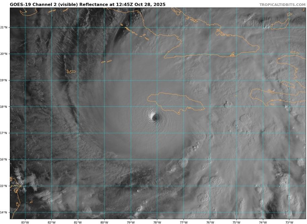
From the National #Hurricane Center regarding the landfall of #Melissa. Currently down to a Cat 4 as it carves across the island of #Jamaica. Eye is closing off but has the chance to undergo an eyewall replacement cycle and strengthen as it exits back out over water before approaching #Cuba. #wx

October 28, 2025 at 8:29 PM
From the National #Hurricane Center regarding the landfall of #Melissa. Currently down to a Cat 4 as it carves across the island of #Jamaica. Eye is closing off but has the chance to undergo an eyewall replacement cycle and strengthen as it exits back out over water before approaching #Cuba. #wx
#Melissa has made landfall near New Hope, Jamaica, with winds of 185 mph and a barometric pressure of 892 mb. Tied with the 1935 Labor Day #hurricane as the strongest landfall on record in the Atlantic. #wx

October 28, 2025 at 5:32 PM
#Melissa has made landfall near New Hope, Jamaica, with winds of 185 mph and a barometric pressure of 892 mb. Tied with the 1935 Labor Day #hurricane as the strongest landfall on record in the Atlantic. #wx
Max winds are 185mph. Pressure 892mb. Category 5 #Melissa coming ashore in #Jamaica. Tied for the third strongest Atlantic #hurricane on record based on barometric pressure. If it reaches wind speeds of 190mph it will be tied with Allen (1980) as the strongest based on winds. #wx


October 28, 2025 at 2:26 PM
Max winds are 185mph. Pressure 892mb. Category 5 #Melissa coming ashore in #Jamaica. Tied for the third strongest Atlantic #hurricane on record based on barometric pressure. If it reaches wind speeds of 190mph it will be tied with Allen (1980) as the strongest based on winds. #wx
#Melissa joins the 800 club. Pressure now down to 896 mb. Wind speeds up to 180 mph. The sixth strongest Atlantic #hurricane based on pressure. Intensification continues as Melissa approaches the coastline of #Jamaica. #wx
October 28, 2025 at 1:17 PM
#Melissa joins the 800 club. Pressure now down to 896 mb. Wind speeds up to 180 mph. The sixth strongest Atlantic #hurricane based on pressure. Intensification continues as Melissa approaches the coastline of #Jamaica. #wx
#HurricaneMelissa is a buzzsaw of a storm this morning. Pressure still dropping. 901mb. Only six Atlantic hurricanes have reached barometric pressure in the 800s. The record for lowest pressure is Wilma (2005) - 882mb. Landfall expected in #Jamaica later today. #wx
October 28, 2025 at 8:29 AM
#HurricaneMelissa is a buzzsaw of a storm this morning. Pressure still dropping. 901mb. Only six Atlantic hurricanes have reached barometric pressure in the 800s. The record for lowest pressure is Wilma (2005) - 882mb. Landfall expected in #Jamaica later today. #wx
Earlier from the #Hurricane Center. The Hurricane Hunters had to abort their mission into #Melissa due to severe turbulence in the eyewall. #wx

October 27, 2025 at 6:19 PM
Earlier from the #Hurricane Center. The Hurricane Hunters had to abort their mission into #Melissa due to severe turbulence in the eyewall. #wx
Still intensifying. #Melissa producing max sustained winds near 175mph. Barometric pressure dropping to 906mb. Record for the fastest winds in an Atlantic #hurricane belongs to Allen (1980), which had wind speeds near 190mph. #wx
October 27, 2025 at 5:52 PM
Still intensifying. #Melissa producing max sustained winds near 175mph. Barometric pressure dropping to 906mb. Record for the fastest winds in an Atlantic #hurricane belongs to Allen (1980), which had wind speeds near 190mph. #wx
#Melissa is a Category 5 #hurricane with wind speeds near 160mph. Landfall expected Tuesday in #Jamaica. This is the 3rd Cat 5 storm of the 2025 season. The last time the Atlantic produced three of more Cat 5 systems was 2005 (4 produced). #wx
October 27, 2025 at 12:10 PM
#Melissa is a Category 5 #hurricane with wind speeds near 160mph. Landfall expected Tuesday in #Jamaica. This is the 3rd Cat 5 storm of the 2025 season. The last time the Atlantic produced three of more Cat 5 systems was 2005 (4 produced). #wx
#Melissa exploding in intensity today. From a Tropical Storm this morning to now a major Category 3 #hurricane. Further strengthening is expected as it crawls westward tonight. Hurricane Warning up for #Jamaica. #wx
October 26, 2025 at 3:07 AM
#Melissa exploding in intensity today. From a Tropical Storm this morning to now a major Category 3 #hurricane. Further strengthening is expected as it crawls westward tonight. Hurricane Warning up for #Jamaica. #wx
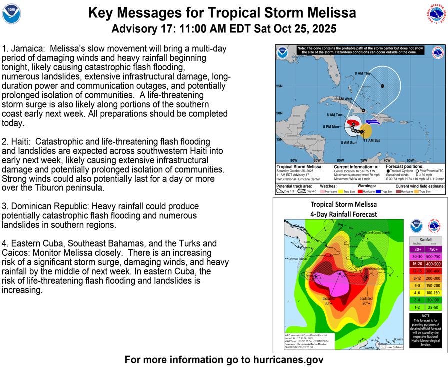
#Melissa close to #hurricane status. Expected to become a major hurricane (Category 3+) over the weekend. It will be Melissa’s extremely slow forward speed that will be the main concern. Especially for #Jamaica. Very heavy rainfall, long-lasting strong winds, and storm surge. #wx

October 25, 2025 at 4:10 PM
#Melissa close to #hurricane status. Expected to become a major hurricane (Category 3+) over the weekend. It will be Melissa’s extremely slow forward speed that will be the main concern. Especially for #Jamaica. Very heavy rainfall, long-lasting strong winds, and storm surge. #wx
A big thank you to NWS Jacksonville, Ben Nelson, Scott Cordero, and Kip Bricker for welcoming my Jacksonville University Aviation Meteorology students to the facility. Students got to make connections to the #weather community, launch a weather balloon, and witness TAFs being created. #wx


October 25, 2025 at 2:49 PM
Crisp temperatures and a mostly clear evening across Northeast #Florida as high pressure settles over the region. Beautiful sunset in #SaintAugustine. #wx

October 23, 2025 at 10:49 PM
Crisp temperatures and a mostly clear evening across Northeast #Florida as high pressure settles over the region. Beautiful sunset in #SaintAugustine. #wx
No surprise if #Melissa intensifies into a major #hurricane in the next few days. Blocking high pressure to the north will keep Melissa situated in the warm waters of the #Caribbean, moving very slowly. Days of heavy rainfall & breezy winds to impact parts of the Greater Antilles. #wx


October 22, 2025 at 11:53 PM
No surprise if #Melissa intensifies into a major #hurricane in the next few days. Blocking high pressure to the north will keep Melissa situated in the warm waters of the #Caribbean, moving very slowly. Days of heavy rainfall & breezy winds to impact parts of the Greater Antilles. #wx
Welcome to midterms week. 🖊️

October 14, 2025 at 8:59 PM
Welcome to midterms week. 🖊️
This will be a common sight across #SaintAugustine into the weekend. Continuous periods of heavy rainfall combined with a developing Nor’easter off the coast will contribute to flooding across the area. Never drive through flooded roadways. Good news: much drier next week. #wx


October 10, 2025 at 2:35 PM
This will be a common sight across #SaintAugustine into the weekend. Continuous periods of heavy rainfall combined with a developing Nor’easter off the coast will contribute to flooding across the area. Never drive through flooded roadways. Good news: much drier next week. #wx
Reposted by Dr. Athena Masson

Seven years ago today, Hurricane Michael continued to intensify as it headed north toward the coast. It made landfall near Mexico Beach FL with 160mph peak sustained winds, making it the 1st Category 5 landfall in the FL panhandle and only the 4th in U.S. history.
October 10, 2025 at 2:24 PM
Seven years ago today, Hurricane Michael continued to intensify as it headed north toward the coast. It made landfall near Mexico Beach FL with 160mph peak sustained winds, making it the 1st Category 5 landfall in the FL panhandle and only the 4th in U.S. history.
Personally I am disappointed. This was the perfect opportunity to name a beast of a storm #Karen 😂 Instead a subtropical low pressure has been given the name in the northern Atlantic. Not a lot of moisture associated with this system but winds are reaching tropical storm status. #wx


October 10, 2025 at 12:56 PM
We have Tropical Storm #Jerry in the central Atlantic gradually moving westward. Strengthening is expected over the next few days and likely could become a #hurricane. A Tropical Storm Watch has been issued for portions of the northern Leeward Islands. #wx


October 7, 2025 at 8:40 PM
We have Tropical Storm #Jerry in the central Atlantic gradually moving westward. Strengthening is expected over the next few days and likely could become a #hurricane. A Tropical Storm Watch has been issued for portions of the northern Leeward Islands. #wx
An extensive forensic analysis of a deadly June tornado in North Dakota helped National Weather Service teams confirm the first EF-5 #tornado in the U.S. in more than 12 years. The tornado was one of 25 twisters that night. #wx
www.accuweather.com/en/severe-we...
www.accuweather.com/en/severe-we...

The first EF5 tornado since 2013 has been confirmed in North Dakota
This tornado, which knocked a train off its tracks, ends the 12-year 'drought' of EF5 tornadoes since the Moore, Oklahoma storm in 2013.
www.accuweather.com
October 6, 2025 at 4:51 PM
An extensive forensic analysis of a deadly June tornado in North Dakota helped National Weather Service teams confirm the first EF-5 #tornado in the U.S. in more than 12 years. The tornado was one of 25 twisters that night. #wx
www.accuweather.com/en/severe-we...
www.accuweather.com/en/severe-we...