


Veer
@veeringwindswx.bsky.social
Weather enthusiast from the mid-Atlantic. Jack of all trades generally - winter, severe, tropics, etc. Whatever's active at the time!
Reposted by Veer
Here are updated verifications for 2025, AL/EP combined, EMXI not available. Impressed that NHC is beating everything, including consensus, for intensity, and everything but Google DeepMind (GDMI) for track. Rough year for GFS and the statistical intensity aids. Banner year for GDMI.


October 31, 2025 at 4:52 PM
Here are updated verifications for 2025, AL/EP combined, EMXI not available. Impressed that NHC is beating everything, including consensus, for intensity, and everything but Google DeepMind (GDMI) for track. Rough year for GFS and the statistical intensity aids. Banner year for GDMI.
Reposted by Veer

Your wish is my command - the super ensemble viewer is back online! Just go to the "superensemble" tab for any storm that has it.
The static images are back for most plots - I'll add the interactive viewer and a few other plots in the coming days.
polarwx.com/tropical/?st...
The static images are back for most plots - I'll add the interactive viewer and a few other plots in the coming days.
polarwx.com/tropical/?st...
September 26, 2025 at 1:17 AM
Your wish is my command - the super ensemble viewer is back online! Just go to the "superensemble" tab for any storm that has it.
The static images are back for most plots - I'll add the interactive viewer and a few other plots in the coming days.
polarwx.com/tropical/?st...
The static images are back for most plots - I'll add the interactive viewer and a few other plots in the coming days.
polarwx.com/tropical/?st...
Reposted by Veer

Pretty neat radar evolution w/ #Gabrielle which rapidly intensified into a Cat 4 #hurricane today.
An eyewall replacement cycle occurred, but instead of the typical cycle of the inner replacing the outer eyewall, it appears the two eyewalls merged & did not interrupt continued intensification.
An eyewall replacement cycle occurred, but instead of the typical cycle of the inner replacing the outer eyewall, it appears the two eyewalls merged & did not interrupt continued intensification.
September 22, 2025 at 10:23 PM
Pretty neat radar evolution w/ #Gabrielle which rapidly intensified into a Cat 4 #hurricane today.
An eyewall replacement cycle occurred, but instead of the typical cycle of the inner replacing the outer eyewall, it appears the two eyewalls merged & did not interrupt continued intensification.
An eyewall replacement cycle occurred, but instead of the typical cycle of the inner replacing the outer eyewall, it appears the two eyewalls merged & did not interrupt continued intensification.
Reposted by Veer

To complement excellent graphics like the one Brian provided (see quoted post), I crafted a storm-following animation of Hurricane Katrina (2005) using NOAA's half-hourly, 4-km multi-satellite merged infrared dataset called Merged IR.
August 22, 2025 at 3:35 PM
To complement excellent graphics like the one Brian provided (see quoted post), I crafted a storm-following animation of Hurricane Katrina (2005) using NOAA's half-hourly, 4-km multi-satellite merged infrared dataset called Merged IR.
Reposted by Veer
#Hurricane #Erin has just become a Category 5 hurricane (140 kt / 917 mb).
Earliest known occurrence of Cat 5 in open Atlantic (outside Caribbean & Gulf).
Rapid Intensification (+75 kt in 24h!)
To illustrate how remarkable this period of #RI has been check out this WV 18 hour animation below ⤵️
Earliest known occurrence of Cat 5 in open Atlantic (outside Caribbean & Gulf).
Rapid Intensification (+75 kt in 24h!)
To illustrate how remarkable this period of #RI has been check out this WV 18 hour animation below ⤵️
August 16, 2025 at 3:51 PM
#Hurricane #Erin has just become a Category 5 hurricane (140 kt / 917 mb).
Earliest known occurrence of Cat 5 in open Atlantic (outside Caribbean & Gulf).
Rapid Intensification (+75 kt in 24h!)
To illustrate how remarkable this period of #RI has been check out this WV 18 hour animation below ⤵️
Earliest known occurrence of Cat 5 in open Atlantic (outside Caribbean & Gulf).
Rapid Intensification (+75 kt in 24h!)
To illustrate how remarkable this period of #RI has been check out this WV 18 hour animation below ⤵️
Reposted by Veer
Tampa, FL reached 100 degrees today, the first such instance in the station's recorded data thread since 1890.
How did this happen?
On the synoptic scale, an anomalous upper-level ridge traversing the region from east to west: (1/3)
How did this happen?
On the synoptic scale, an anomalous upper-level ridge traversing the region from east to west: (1/3)

July 28, 2025 at 12:54 AM
Tampa, FL reached 100 degrees today, the first such instance in the station's recorded data thread since 1890.
How did this happen?
On the synoptic scale, an anomalous upper-level ridge traversing the region from east to west: (1/3)
How did this happen?
On the synoptic scale, an anomalous upper-level ridge traversing the region from east to west: (1/3)
Reposted by Veer
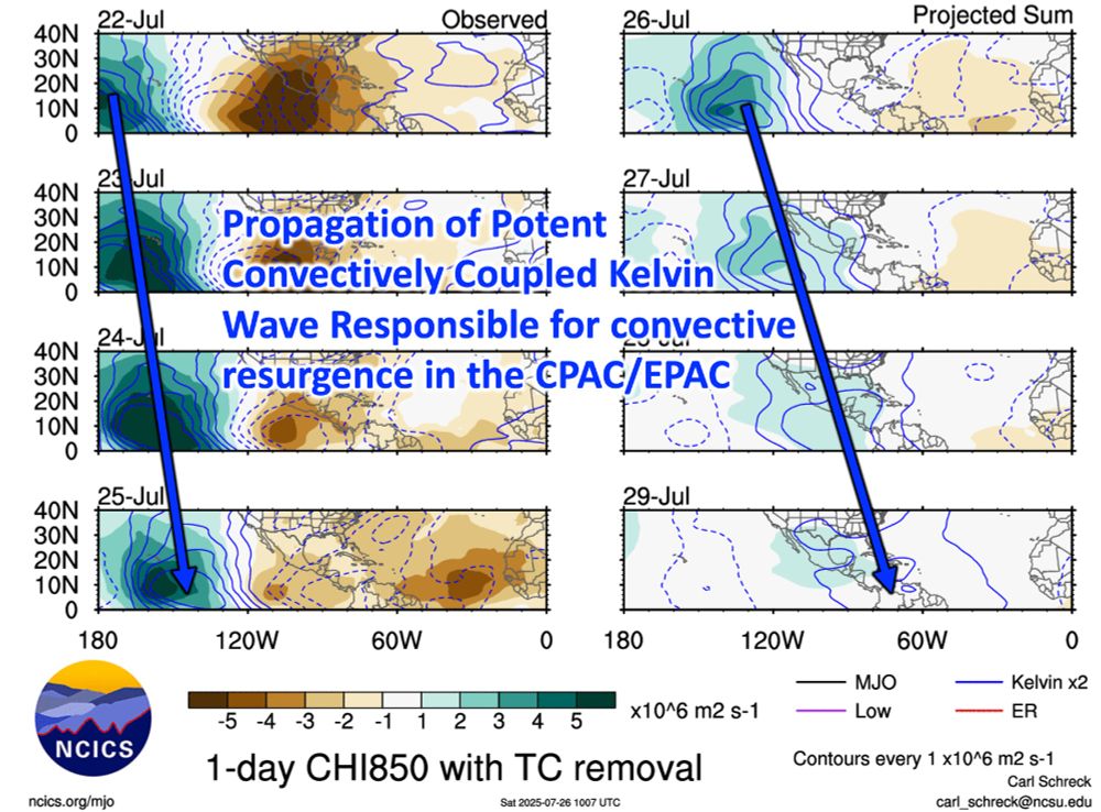
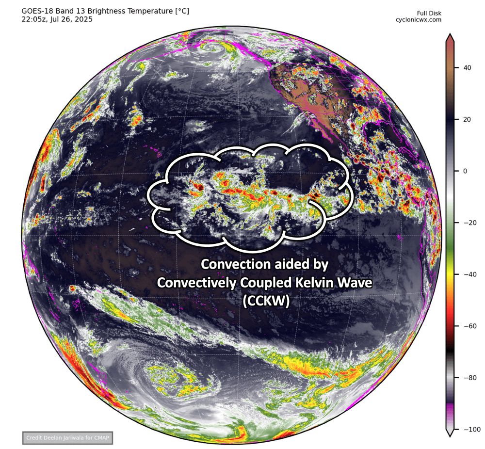
Not hard to see what is causing the abrupt uptick in convective activity in the Central & East Pacific. A potent Convectively Coupled Kelvin Wave, #CCKW, has been marching eastward, activating the #ITCZ.
This convection may aid #ITCZ breakdown, with 3️⃣ areas being monitored for #TC formation.
This convection may aid #ITCZ breakdown, with 3️⃣ areas being monitored for #TC formation.

July 26, 2025 at 10:48 PM
Reposted by Veer
It's been a bit since I've done a meteorological deep dive, but the devastating flash #flood in central Texas this July 4th/5th deserve a closer look. #TXwx
Yes remnants of #Barry were involved helping enhance moisture. A remnant MCV from Mexico on 3 July also played a role.
Full evolution below ⤵️
Yes remnants of #Barry were involved helping enhance moisture. A remnant MCV from Mexico on 3 July also played a role.
Full evolution below ⤵️
July 5, 2025 at 10:00 PM
Reposted by Veer

Today was the last day at NOAA for hundreds of employees who took an early retirement offer. Collectively, an estimated 27,000 years of experience left the agency. It goes without saying they will be missed. Their decades of service is commendable & appreciated.
m.youtube.com/watch?v=Si-R...
m.youtube.com/watch?v=Si-R...
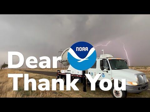
Dear NOAA: Thank You
YouTube video by Cole Vaughn
m.youtube.com
April 30, 2025 at 11:29 PM
Today was the last day at NOAA for hundreds of employees who took an early retirement offer. Collectively, an estimated 27,000 years of experience left the agency. It goes without saying they will be missed. Their decades of service is commendable & appreciated.
m.youtube.com/watch?v=Si-R...
m.youtube.com/watch?v=Si-R...
Reposted by Veer
Saw a post from @vortexjeff.bsky.social on The Other Site, and was interested to understand how one would advect such an impressive EML into northwestern Oregon. If I ran HYSPLIT correctly (perhaps a tenuous assumption), it looks like the source region was somewhere in the northern Sierra.


March 26, 2025 at 5:53 PM
Saw a post from @vortexjeff.bsky.social on The Other Site, and was interested to understand how one would advect such an impressive EML into northwestern Oregon. If I ran HYSPLIT correctly (perhaps a tenuous assumption), it looks like the source region was somewhere in the northern Sierra.
Reposted by Veer

AguaceroWx FREE OPEN BETA is LIVE for limited time! Already have an account? Go to aguacerowx.com/app. Need to register? Visit aguacerowx.com/register. We welcome your feedback!
Join our discord here to get updates/make suggestions! discord.gg/HxkzgbrFjt
Join our discord here to get updates/make suggestions! discord.gg/HxkzgbrFjt

March 9, 2025 at 9:08 PM
AguaceroWx FREE OPEN BETA is LIVE for limited time! Already have an account? Go to aguacerowx.com/app. Need to register? Visit aguacerowx.com/register. We welcome your feedback!
Join our discord here to get updates/make suggestions! discord.gg/HxkzgbrFjt
Join our discord here to get updates/make suggestions! discord.gg/HxkzgbrFjt
Reposted by Veer

Contiguous U.S. winter temperature categories. 25% of the Lower 48 is in some shade of red and 15% is in some shade of blue. This is in comparison to the 1991-2020 climate normal period - which is quite a bit warmer than previous periods.

March 5, 2025 at 6:21 AM
Contiguous U.S. winter temperature categories. 25% of the Lower 48 is in some shade of red and 15% is in some shade of blue. This is in comparison to the 1991-2020 climate normal period - which is quite a bit warmer than previous periods.
Reposted by Veer


Very encouraging. What is even happening anymore

February 28, 2025 at 3:59 PM
Very encouraging. What is even happening anymore
That’s the Constitution mate. The literal Constitution

February 28, 2025 at 2:36 PM
That’s the Constitution mate. The literal Constitution
Reposted by Veer

All probationary federal employees at NOAA’s EMC that’s responsible for keeping all US weather model systems running have been fired with 1 hours notice. And that includes me and colleagues. We will not go quietly because we care about the NOAA mission to protect the public.
February 27, 2025 at 9:18 PM
All probationary federal employees at NOAA’s EMC that’s responsible for keeping all US weather model systems running have been fired with 1 hours notice. And that includes me and colleagues. We will not go quietly because we care about the NOAA mission to protect the public.
First post in a good bit:
Eyeing the third week of March for a serious ramp up in severe weather across the US. MJO stalls & strengthens in the Maritime Continent without competing forcing in the WHEM beginning mid month and lasting perhaps longer than a week.
Eyeing the third week of March for a serious ramp up in severe weather across the US. MJO stalls & strengthens in the Maritime Continent without competing forcing in the WHEM beginning mid month and lasting perhaps longer than a week.


February 25, 2025 at 6:59 AM
First post in a good bit:
Eyeing the third week of March for a serious ramp up in severe weather across the US. MJO stalls & strengthens in the Maritime Continent without competing forcing in the WHEM beginning mid month and lasting perhaps longer than a week.
Eyeing the third week of March for a serious ramp up in severe weather across the US. MJO stalls & strengthens in the Maritime Continent without competing forcing in the WHEM beginning mid month and lasting perhaps longer than a week.
Reposted by Veer
@brandonskalniak.bsky.social has been helping me with weather history for a while now. He recently completed his Radar Museum with 5319 entries. Please, have a look!
www.brandoweather.com/radar-museum
www.brandoweather.com/radar-museum

February 23, 2025 at 1:13 AM
@brandonskalniak.bsky.social has been helping me with weather history for a while now. He recently completed his Radar Museum with 5319 entries. Please, have a look!
www.brandoweather.com/radar-museum
www.brandoweather.com/radar-museum
Reposted by Veer

The PDF that detailed NOAA’s Radar Next Program was deleted by Executive Order
www.noaa.gov/sites/defaul...
www.noaa.gov/sites/defaul...


February 16, 2025 at 7:24 PM
The PDF that detailed NOAA’s Radar Next Program was deleted by Executive Order
www.noaa.gov/sites/defaul...
www.noaa.gov/sites/defaul...
Reposted by Veer

Snow easing but not over. How much more we project:
North of Beltway: 0.5-1.5"
Near Beltway: ~ 2"
South of Betlway: 2-3"
This would bring totals to 1.5 to 4.5" N of Beltway, 5 to 7" near Beltway and 6-11" to south. Yes, a boom for some.
More info at cwg.live
North of Beltway: 0.5-1.5"
Near Beltway: ~ 2"
South of Betlway: 2-3"
This would bring totals to 1.5 to 4.5" N of Beltway, 5 to 7" near Beltway and 6-11" to south. Yes, a boom for some.
More info at cwg.live

February 12, 2025 at 1:54 AM
Snow easing but not over. How much more we project:
North of Beltway: 0.5-1.5"
Near Beltway: ~ 2"
South of Betlway: 2-3"
This would bring totals to 1.5 to 4.5" N of Beltway, 5 to 7" near Beltway and 6-11" to south. Yes, a boom for some.
More info at cwg.live
North of Beltway: 0.5-1.5"
Near Beltway: ~ 2"
South of Betlway: 2-3"
This would bring totals to 1.5 to 4.5" N of Beltway, 5 to 7" near Beltway and 6-11" to south. Yes, a boom for some.
More info at cwg.live
Reposted by Veer
Reminder that if there is a government shutdown, some NOAA websites like NCEI (ncei.noaa.gov, archived weather databases) and PSL (psl.noaa.gov) are likely to be offline — if you rely on them, the next few days are a good time to download data you need.
December 19, 2024 at 3:08 AM
Reminder that if there is a government shutdown, some NOAA websites like NCEI (ncei.noaa.gov, archived weather databases) and PSL (psl.noaa.gov) are likely to be offline — if you rely on them, the next few days are a good time to download data you need.
Reposted by Veer
For the first time in quite a while, December looks to be off to a colder than average start in the eastern United States.
The biggest difference vs. past Decembers? The absence of troughing anchored over the Northeast Pacific & Northwest US, which has been present in almost every recent December.
The biggest difference vs. past Decembers? The absence of troughing anchored over the Northeast Pacific & Northwest US, which has been present in almost every recent December.


November 20, 2024 at 11:26 PM
For the first time in quite a while, December looks to be off to a colder than average start in the eastern United States.
The biggest difference vs. past Decembers? The absence of troughing anchored over the Northeast Pacific & Northwest US, which has been present in almost every recent December.
The biggest difference vs. past Decembers? The absence of troughing anchored over the Northeast Pacific & Northwest US, which has been present in almost every recent December.
Reposted by Veer
Worth recapping how remarkable last two weeks have been in the WPAC with #TC activity.
4️⃣ #Typhoons ( #Yinxing, #Toraji, #Usagi, #Man-Yi ) hit the #Philippeans in just *9️⃣* days!!!!
Unprecedented in modern records. 3 of the typhoons were Cat 4 or stronger! The full two week animation is below 👇
4️⃣ #Typhoons ( #Yinxing, #Toraji, #Usagi, #Man-Yi ) hit the #Philippeans in just *9️⃣* days!!!!
Unprecedented in modern records. 3 of the typhoons were Cat 4 or stronger! The full two week animation is below 👇
November 18, 2024 at 11:49 PM
Reposted by Veer
I plan to eventually transfer my website from my old OU host to a separate server, but in the meantime, I wrote a detailed blog post about the challenges of forecasting Tropical Storm Sara and what went wrong:
arctic.som.ou.edu/tburg/blog/p...
arctic.som.ou.edu/tburg/blog/p...

November 17, 2024 at 12:34 AM
I plan to eventually transfer my website from my old OU host to a separate server, but in the meantime, I wrote a detailed blog post about the challenges of forecasting Tropical Storm Sara and what went wrong:
arctic.som.ou.edu/tburg/blog/p...
arctic.som.ou.edu/tburg/blog/p...