


Veer
@veeringwindswx.bsky.social
Weather enthusiast from the mid-Atlantic. Jack of all trades generally - winter, severe, tropics, etc. Whatever's active at the time!
Very encouraging. What is even happening anymore

February 28, 2025 at 3:59 PM
Very encouraging. What is even happening anymore
That’s the Constitution mate. The literal Constitution

February 28, 2025 at 2:36 PM
That’s the Constitution mate. The literal Constitution
First post in a good bit:
Eyeing the third week of March for a serious ramp up in severe weather across the US. MJO stalls & strengthens in the Maritime Continent without competing forcing in the WHEM beginning mid month and lasting perhaps longer than a week.
Eyeing the third week of March for a serious ramp up in severe weather across the US. MJO stalls & strengthens in the Maritime Continent without competing forcing in the WHEM beginning mid month and lasting perhaps longer than a week.


February 25, 2025 at 6:59 AM
First post in a good bit:
Eyeing the third week of March for a serious ramp up in severe weather across the US. MJO stalls & strengthens in the Maritime Continent without competing forcing in the WHEM beginning mid month and lasting perhaps longer than a week.
Eyeing the third week of March for a serious ramp up in severe weather across the US. MJO stalls & strengthens in the Maritime Continent without competing forcing in the WHEM beginning mid month and lasting perhaps longer than a week.
Trends within a subtle steering regime are hard to ignore with #99L. It wasn’t clear how much influence the distant weak TUTT would exert on track, but subtropical ridging is now forecast to build in stronger and faster - which in turn lowers the intensity ceiling.
November 14, 2024 at 12:58 AM
Trends within a subtle steering regime are hard to ignore with #99L. It wasn’t clear how much influence the distant weak TUTT would exert on track, but subtropical ridging is now forecast to build in stronger and faster - which in turn lowers the intensity ceiling.
It is remarkable to see how quickly #Rafael's polar outflow channel has opened up today as the upstream ridge as finally progressed eastward. Such dramatic outflow expansion can be an important RI indicator, which fits well with today's trends.
November 6, 2024 at 12:42 AM
It is remarkable to see how quickly #Rafael's polar outflow channel has opened up today as the upstream ridge as finally progressed eastward. Such dramatic outflow expansion can be an important RI indicator, which fits well with today's trends.
Complex synoptic setup ahead for the upcoming TC in the western Caribbean. As the upstream ridge over E CONUS progresses eastward and anticyclonic outflow from #97L expands, the primary shortwave trough will cutoff and retrograde to the SW, creating a favorable UL environment for RI.


November 3, 2024 at 5:52 PM
Complex synoptic setup ahead for the upcoming TC in the western Caribbean. As the upstream ridge over E CONUS progresses eastward and anticyclonic outflow from #97L expands, the primary shortwave trough will cutoff and retrograde to the SW, creating a favorable UL environment for RI.
In addition, low-level saturation tends to work better in such QLCS scenarios when dealing with tornado production - usually it would be a significant hindrance.

November 3, 2024 at 2:53 AM
In addition, low-level saturation tends to work better in such QLCS scenarios when dealing with tornado production - usually it would be a significant hindrance.
The squall will trek into a more surface-based instability profile deeper into the night as the earlier convection has left a void yet to be filled by the strong advection. Watch for NW/SE oriented bookends given the SWly 0-3 km shear - N/S will also work given 40 kt magnitude.
November 3, 2024 at 2:53 AM
The squall will trek into a more surface-based instability profile deeper into the night as the earlier convection has left a void yet to be filled by the strong advection. Watch for NW/SE oriented bookends given the SWly 0-3 km shear - N/S will also work given 40 kt magnitude.
I do think quite a few tornadoes will occur overnight across Oklahoma in association with the WAA regime - there could be a couple tornadic prefrontal supercells followed by a maturing, very efficient tornado-producing QLCS. Look out for squall line interactions especially. (1/3)


November 3, 2024 at 2:48 AM
I do think quite a few tornadoes will occur overnight across Oklahoma in association with the WAA regime - there could be a couple tornadic prefrontal supercells followed by a maturing, very efficient tornado-producing QLCS. Look out for squall line interactions especially. (1/3)
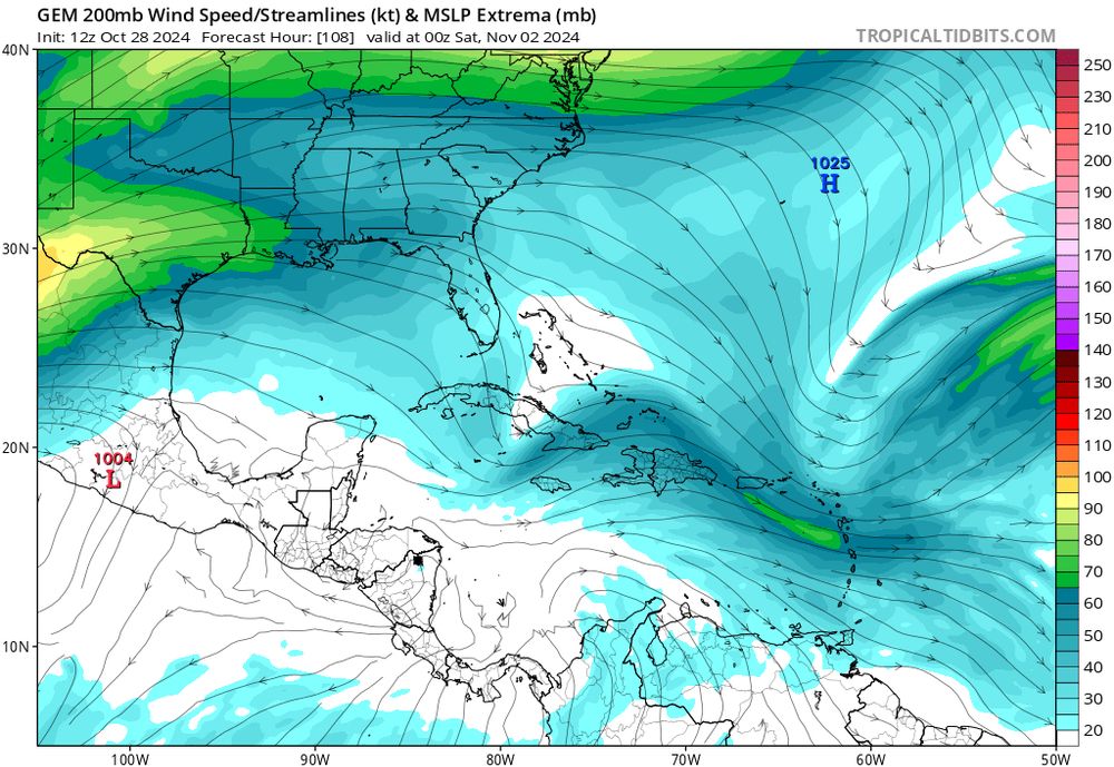
An important part of our Caribbean TCG potential will be a shortwave entering the gulf in a couple days & making its way into the northern Caribbean by the end of the week. The amplitude and placement of this feature is vital - e.g. the Euro solution wouldn’t favor TCG with how far south it is.


October 28, 2024 at 4:32 PM
An important part of our Caribbean TCG potential will be a shortwave entering the gulf in a couple days & making its way into the northern Caribbean by the end of the week. The amplitude and placement of this feature is vital - e.g. the Euro solution wouldn’t favor TCG with how far south it is.
Sifted through center dropsonde pressure data for #Milton this morning - pretty interesting! Using a couple data points from the midday mission and a few from the evening post-peak mission, I also interpolated a peak pressure of ~894.7 mb at ~21z using a quadratic regression with r^2=0.998. #wxsky

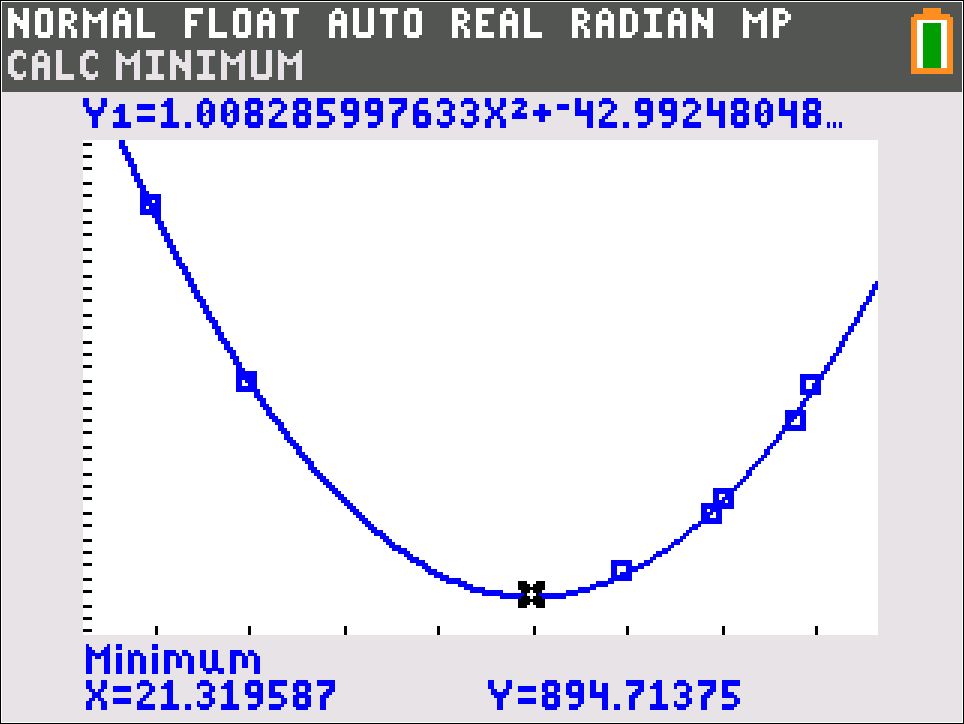
October 28, 2024 at 11:54 AM
Warm seclusion activities @drmetwatch.bsky.social


October 27, 2024 at 1:58 PM
Warm seclusion activities @drmetwatch.bsky.social


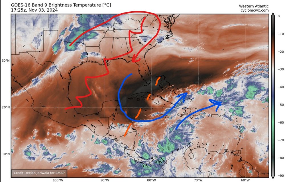
A few graphics regarding the synoptic setup that accompanies likely TCG in the Caribbean #tropicswx #wxsky (1/3)
October 27, 2024 at 11:41 AM
A few graphics regarding the synoptic setup that accompanies likely TCG in the Caribbean #tropicswx #wxsky (1/3)

A potential STC developing underneath an upper low in the north Pacific seems to have gone under the radar! Look out for a cool swirl in the next couple days.


October 22, 2024 at 10:49 PM
A potential STC developing underneath an upper low in the north Pacific seems to have gone under the radar! Look out for a cool swirl in the next couple days.
Just as a side note, it's been wild to watch how frequently convection pulses up and down within the CDO of #Oscar during its 24 hours as a TC so far. The sustenance of a remarkably compact core is something to behold!
October 20, 2024 at 4:52 AM
Just as a side note, it's been wild to watch how frequently convection pulses up and down within the CDO of #Oscar during its 24 hours as a TC so far. The sustenance of a remarkably compact core is something to behold!
Hey @burgwx.bsky.social this looks awfully similar to a graph about a year ago!
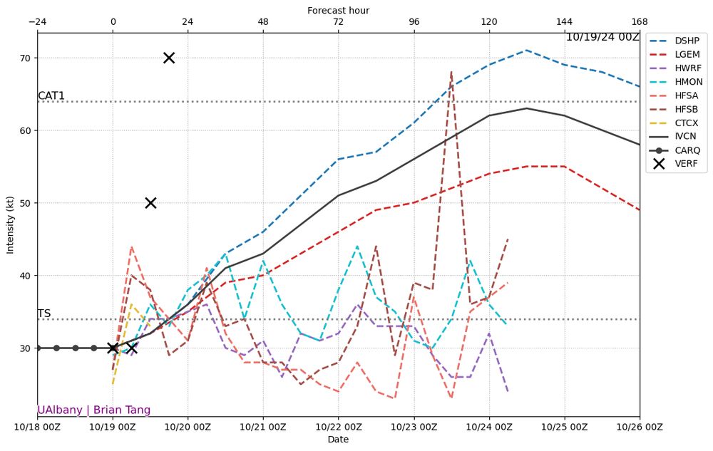
October 19, 2024 at 8:23 PM
Hey @burgwx.bsky.social this looks awfully similar to a graph about a year ago!
After an active time for TCs in the eastern hemisphere over the next week or so, the MJO is forecast to propagate rather quickly into the western Atlantic around the tail end of the month. The WCAR is climatologically favored, so keep an eye out for the first week of November w/ warming SSTs.


October 18, 2024 at 8:43 AM
After an active time for TCs in the eastern hemisphere over the next week or so, the MJO is forecast to propagate rather quickly into the western Atlantic around the tail end of the month. The WCAR is climatologically favored, so keep an eye out for the first week of November w/ warming SSTs.
Switching over to tropics for a second, the MLC associated with #95L is becoming more likely to cross into the EPAC in a few days, and re-development looks rather probable in the medium range.


October 18, 2024 at 7:51 AM
Switching over to tropics for a second, the MLC associated with #95L is becoming more likely to cross into the EPAC in a few days, and re-development looks rather probable in the medium range.
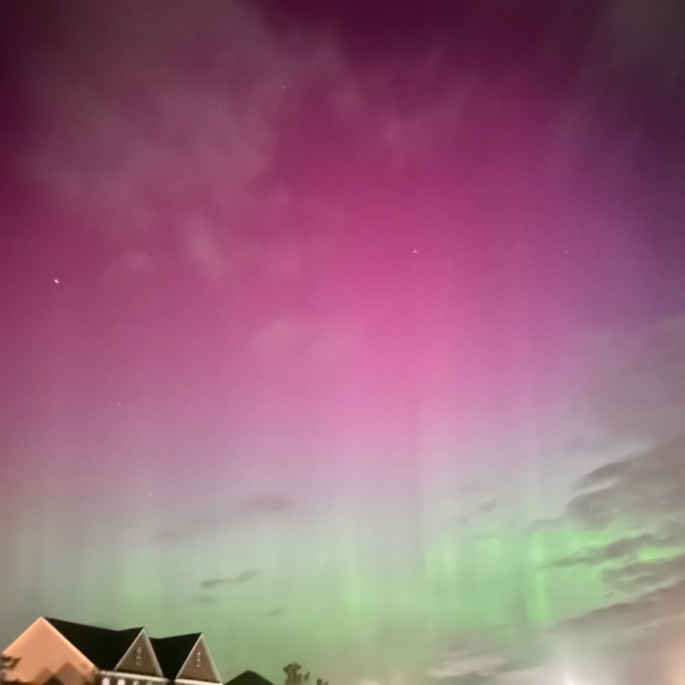
Oh yeah I figure I should post some of my cool sky pics or whatever. None of these feature a blue sky!


October 17, 2024 at 7:36 PM
Oh yeah I figure I should post some of my cool sky pics or whatever. None of these feature a blue sky!
Looks like a synoptically appetizing setup for NM on Friday, if it wasn't for extremely marginal thermos! Lift arrives after dark per RAP - wouldn't rule out a couple tornadoes in the narrow region of favorability with a moistening boundary layer overnight.


October 17, 2024 at 6:23 AM
Looks like a synoptically appetizing setup for NM on Friday, if it wasn't for extremely marginal thermos! Lift arrives after dark per RAP - wouldn't rule out a couple tornadoes in the narrow region of favorability with a moistening boundary layer overnight.
Is this bluesky's version of that circle thing we had on wxtwitter? Obligatory 10M users post to fit in...

September 17, 2024 at 6:53 AM
Is this bluesky's version of that circle thing we had on wxtwitter? Obligatory 10M users post to fit in...