


The Viabundus Map
@viabundus.bsky.social
This is the international viabundus-project, digitally recreating Northern Europe's route-network around 1500. 🇩🇪🇳🇱🇩🇰🇫🇮🇸🇪More on http://www.viabundus.eu
Reposted by The Viabundus Map
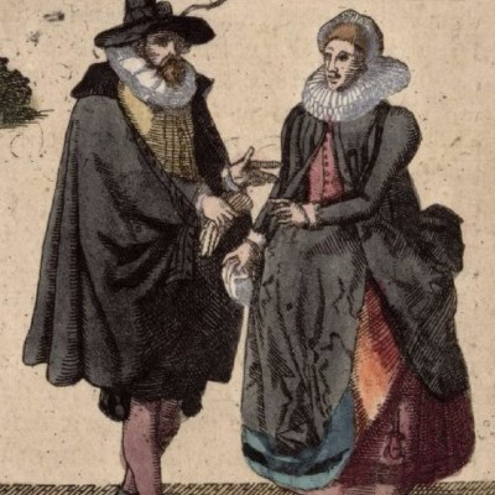
Breslau, 11. Feb 1626
Freitags ist des Bethlens Braut [1] allhie über Nacht geblieben / die hat 40 Wägen / jeden mit 6 Pferden bei sich - Bürgerschaft mit 200 Pferden, Landobrist von Dohna und viele Adelige ihr entgegen geritten.
aus:
brema.suub.uni-bremen.de/zeitungen17/...
Freitags ist des Bethlens Braut [1] allhie über Nacht geblieben / die hat 40 Wägen / jeden mit 6 Pferden bei sich - Bürgerschaft mit 200 Pferden, Landobrist von Dohna und viele Adelige ihr entgegen geritten.
aus:
brema.suub.uni-bremen.de/zeitungen17/...

February 12, 2026 at 5:38 AM
Breslau, 11. Feb 1626
Freitags ist des Bethlens Braut [1] allhie über Nacht geblieben / die hat 40 Wägen / jeden mit 6 Pferden bei sich - Bürgerschaft mit 200 Pferden, Landobrist von Dohna und viele Adelige ihr entgegen geritten.
aus:
brema.suub.uni-bremen.de/zeitungen17/...
Freitags ist des Bethlens Braut [1] allhie über Nacht geblieben / die hat 40 Wägen / jeden mit 6 Pferden bei sich - Bürgerschaft mit 200 Pferden, Landobrist von Dohna und viele Adelige ihr entgegen geritten.
aus:
brema.suub.uni-bremen.de/zeitungen17/...

January 31, 2026 at 7:40 AM
Reposted by The Viabundus Map
2. Maantie. Maantie ei tarkoita maalla olevaa tietä, vaan on jo keskiaikaisten maan(👈!)lakien tieluokka. Maantie (r. Landsväg) oli koko maakunnan (r. Land, lat. Terra) verotalonpoikien yhteisesti ylläpitämä tie, maa/ linnavoutikuntien välinen tie. Hämeensilta oli keskiajalla yleisen maantien silta.


January 30, 2026 at 2:18 PM
2. Maantie. Maantie ei tarkoita maalla olevaa tietä, vaan on jo keskiaikaisten maan(👈!)lakien tieluokka. Maantie (r. Landsväg) oli koko maakunnan (r. Land, lat. Terra) verotalonpoikien yhteisesti ylläpitämä tie, maa/ linnavoutikuntien välinen tie. Hämeensilta oli keskiajalla yleisen maantien silta.
Reposted by The Viabundus Map
The Newport Arch - the remains of the north gateway to Roman Lincoln (Lindum Colonia). Built in around 200 AD, the arch is the only Roman gateway in the UK still used by traffic. 📸 My own. #RomanSiteSaturday #RomanBritain #Lincoln

January 24, 2026 at 8:37 AM
The Newport Arch - the remains of the north gateway to Roman Lincoln (Lindum Colonia). Built in around 200 AD, the arch is the only Roman gateway in the UK still used by traffic. 📸 My own. #RomanSiteSaturday #RomanBritain #Lincoln
Reposted by The Viabundus Map

This is such a cool illustration of how the Mercator map distorts the size of Greenland, which looks as big as the whole continent of Africa on that map but is actually the size of Mexico.
January 18, 2026 at 7:43 PM
This is such a cool illustration of how the Mercator map distorts the size of Greenland, which looks as big as the whole continent of Africa on that map but is actually the size of Mexico.
Reposted by The Viabundus Map
Nach einem sehr bereichernden Workshop zur vormodernen Mobilität in Osnabrück im letzten Juni wollen Christoph Mauntel und ich das Format dieses Jahr in Kiel fortsetzen. Der CFP findet sich hier: www.hsozkult.de/event/id/eve.... Wir freuen uns auf Vorschläge und sind dankbar fürs Teilen. 🤗
Reisen – pilgern – migrieren
Der Workshop ist ein Forum für Wissenschaftler:innen verschiedener Disziplinen, auf dem Ansätze, Methoden und Zugänge zur Mobilitätsforschung diskutiert werden.
www.hsozkult.de
January 9, 2026 at 11:08 AM
Nach einem sehr bereichernden Workshop zur vormodernen Mobilität in Osnabrück im letzten Juni wollen Christoph Mauntel und ich das Format dieses Jahr in Kiel fortsetzen. Der CFP findet sich hier: www.hsozkult.de/event/id/eve.... Wir freuen uns auf Vorschläge und sind dankbar fürs Teilen. 🤗
Reposted by The Viabundus Map
Shoutout to our dear colleague Dr. Mikola Volkau for his new NAWA funded project "The route to Europe: urbanization and roads in the Grand Duchy of Lithuania from the 16th to the middle of the 17th century" at the Manteuffel Institute of History, Polish Academy of Sciences 2025-2027.

December 18, 2025 at 4:46 PM
Shoutout to our dear colleague Dr. Mikola Volkau for his new NAWA funded project "The route to Europe: urbanization and roads in the Grand Duchy of Lithuania from the 16th to the middle of the 17th century" at the Manteuffel Institute of History, Polish Academy of Sciences 2025-2027.
Reposted by The Viabundus Map

Publication – « Routes d’Orient et d’Occident », éd. Benhima Yassir, Gilotte Sophie, Rousset Marie-Odile (Médiévales, 89)
rmblf.be/2026/01/02/p...
rmblf.be/2026/01/02/p...

Publication – « Routes d’Orient et d’Occident », éd. Benhima Yassir, Gilotte Sophie, Rousset Marie-Odile (Médiévales, 89)
Pèlerins, marchands et autres voyageurs sillonnent les routes médiévales, y compris dans des espaces inhospitaliers, ignorant sans doute que les infrastructures routières qu’ils empruntaient ont fa…
rmblf.be
January 2, 2026 at 7:55 AM
Publication – « Routes d’Orient et d’Occident », éd. Benhima Yassir, Gilotte Sophie, Rousset Marie-Odile (Médiévales, 89)
rmblf.be/2026/01/02/p...
rmblf.be/2026/01/02/p...
Reposted by The Viabundus Map

This is a useful website to quickly view different map projections. Useful when you want to map a specific region and aren't sure what projection to use. Also, it's just good fun to play with: buff.ly/36nJtxQ
Map Projection Explorer
Explore the world in different map projections
buff.ly
January 1, 2026 at 8:01 PM
This is a useful website to quickly view different map projections. Useful when you want to map a specific region and aren't sure what projection to use. Also, it's just good fun to play with: buff.ly/36nJtxQ
Reposted by The Viabundus Map

Oops, left out the url to my web site that explains me more fully...https://kgeographer.org
I'm now seeking part-time development contract(s) after a semi-retirement phase of personal research. Projects or experiments in spatial humanities, geo-inflected NLP, LLM stuff, software design, data modeling & munging all possible. DM me if you think of something and RT if inclined. Thx.
December 21, 2025 at 3:03 AM
Oops, left out the url to my web site that explains me more fully...https://kgeographer.org
Reposted by The Viabundus Map

Driving home for #Christmas 🎄
#medievalsky #medievaladvent
The Morgan Library & Museum, MS M.705, f. 33r
#medievalsky #medievaladvent
The Morgan Library & Museum, MS M.705, f. 33r

December 20, 2025 at 2:56 AM
Driving home for #Christmas 🎄
#medievalsky #medievaladvent
The Morgan Library & Museum, MS M.705, f. 33r
#medievalsky #medievaladvent
The Morgan Library & Museum, MS M.705, f. 33r
Reposted by The Viabundus Map

Reposted by The Viabundus Map
Kysely historiallisista teistä on käynnissä. Väitöskirjatutkija Katrina Virtanen @utu.fi kerää tämän päivän kokemuksia ja muistoja arkisesta kulkemisesta ja suunnitellusta matkanteosta Suomen vanhoilla teillä. Yhteistyössä @viabundus.bsky.social & Postimuseo. Lisätietoa:
sites.utu.fi/humanisticgi...
sites.utu.fi/humanisticgi...

December 19, 2025 at 10:59 AM
Kysely historiallisista teistä on käynnissä. Väitöskirjatutkija Katrina Virtanen @utu.fi kerää tämän päivän kokemuksia ja muistoja arkisesta kulkemisesta ja suunnitellusta matkanteosta Suomen vanhoilla teillä. Yhteistyössä @viabundus.bsky.social & Postimuseo. Lisätietoa:
sites.utu.fi/humanisticgi...
sites.utu.fi/humanisticgi...
Reposted by The Viabundus Map

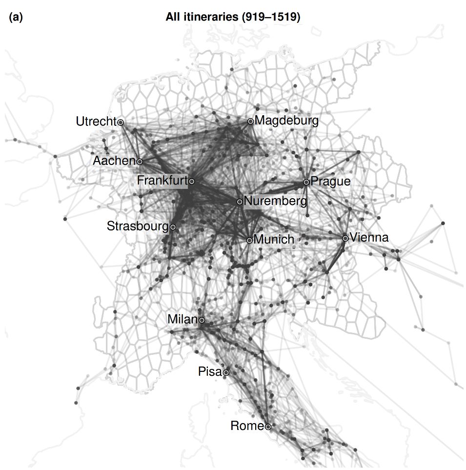
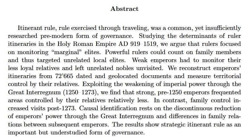
🚨 Very excited that our paper on *Rulers on the Road* has been cond. accepted at the AJPS @ajpseditor.bsky.social. We analyze emperors' strategies of itinerant rule in the Holy Roman Empire 919-1519. Fun working with @claranw.bsky.social, @andrejkokkonen.bsky.social & Jørgen Møller shorturl.at/Spm7z
April 29, 2025 at 3:43 PM
🚨 Very excited that our paper on *Rulers on the Road* has been cond. accepted at the AJPS @ajpseditor.bsky.social. We analyze emperors' strategies of itinerant rule in the Holy Roman Empire 919-1519. Fun working with @claranw.bsky.social, @andrejkokkonen.bsky.social & Jørgen Møller shorturl.at/Spm7z
Shoutout to our dear colleague Dr. Mikola Volkau for his new NAWA funded project "The route to Europe: urbanization and roads in the Grand Duchy of Lithuania from the 16th to the middle of the 17th century" at the Manteuffel Institute of History, Polish Academy of Sciences 2025-2027.
December 18, 2025 at 4:46 PM
Shoutout to our dear colleague Dr. Mikola Volkau for his new NAWA funded project "The route to Europe: urbanization and roads in the Grand Duchy of Lithuania from the 16th to the middle of the 17th century" at the Manteuffel Institute of History, Polish Academy of Sciences 2025-2027.
Reposted by The Viabundus Map

The DIGARV book is now OA! Lots of useful & interesting digital humanities stuff in there.
Chapter 9 is about/by the Mapping Lived Religion project team.
Check it out!
www.vitterhetsakademien.se/nyheter/nyhe...
Chapter 9 is about/by the Mapping Lived Religion project team.
Check it out!
www.vitterhetsakademien.se/nyheter/nyhe...

Ny bok: Digitalisering av kulturarvssamlingar
Boken om forskningsprogrammet Digarv – Digitalisering och tillgängliggörande av kulturarvssamlingar har nu publicerats. I boken beskrivs samtliga fjorton projekt som ingick i programmet som var ett...
www.vitterhetsakademien.se
December 17, 2025 at 7:16 PM
The DIGARV book is now OA! Lots of useful & interesting digital humanities stuff in there.
Chapter 9 is about/by the Mapping Lived Religion project team.
Check it out!
www.vitterhetsakademien.se/nyheter/nyhe...
Chapter 9 is about/by the Mapping Lived Religion project team.
Check it out!
www.vitterhetsakademien.se/nyheter/nyhe...
Reposted by The Viabundus Map
Visbundus Suomi -projektin väitöskirjatutkija Katrina Virtasen tuore projektiesittely Positio-lehdessä. Katrina kerää materiaalia historiallisista teistä kokemuksena, linkki kyselyyn artikkelissa. Eikun vastaamaan!
@viabundus.bsky.social #VuabundusSuomi
@viabundus.bsky.social #VuabundusSuomi
Paikkatietoon erikoistunut Positio-lehti on julkaissut Katrina Virtasen @utu.fi artikkelin Viabundus Finland 1350-1650 -karttajulkaisusta. Uutinen on kirjoitettu hankkeessa sovellettujen paikkatietomenetelmien näkökulmasta.
@viabundus.bsky.social @koneensaatio.fi
positio-lehti.fi/2025/12/suom...
@viabundus.bsky.social @koneensaatio.fi
positio-lehti.fi/2025/12/suom...

Suomen keskiajan ja uuden ajan alun maantiet ja etappipaikat karttaliittymänä | Positio
Suomen keskiaikaiset ja varhaismodernit maantiet ja teiden varsilla olevat etappipaikat on koottu kartalle. Koneen Säätiön rahoittama Viabundus Suomi
positio-lehti.fi
December 15, 2025 at 2:38 PM
Visbundus Suomi -projektin väitöskirjatutkija Katrina Virtasen tuore projektiesittely Positio-lehdessä. Katrina kerää materiaalia historiallisista teistä kokemuksena, linkki kyselyyn artikkelissa. Eikun vastaamaan!
@viabundus.bsky.social #VuabundusSuomi
@viabundus.bsky.social #VuabundusSuomi
Reposted by The Viabundus Map
Tell your boss that I gave you the rest of the week off so you can explore this amazing interactive map showing the road network of the Roman Empire. This is so much fun to explore you can compare the Ancient and Modern road network for example. Your boss will understand... Source: itiner-e.org

December 5, 2025 at 6:38 PM
Tell your boss that I gave you the rest of the week off so you can explore this amazing interactive map showing the road network of the Roman Empire. This is so much fun to explore you can compare the Ancient and Modern road network for example. Your boss will understand... Source: itiner-e.org
Reposted by The Viabundus Map

To GLAM colleagues:
Do you use the GETTY VOCABULARIES? We seek feedback to improve these important resources. Please answer this survey and share it in your circles! It is anonymous although email is collected for context. 10-30 mins to complete. Thank you!
docs.google.com/forms/d/e/1F...
Do you use the GETTY VOCABULARIES? We seek feedback to improve these important resources. Please answer this survey and share it in your circles! It is anonymous although email is collected for context. 10-30 mins to complete. Thank you!
docs.google.com/forms/d/e/1F...

Getty Vocabularies Survey
We're looking to improve the Getty Vocabularies (AAT, ULAN, TGN) and would appreciate your feedback.
docs.google.com
December 3, 2025 at 3:21 PM
To GLAM colleagues:
Do you use the GETTY VOCABULARIES? We seek feedback to improve these important resources. Please answer this survey and share it in your circles! It is anonymous although email is collected for context. 10-30 mins to complete. Thank you!
docs.google.com/forms/d/e/1F...
Do you use the GETTY VOCABULARIES? We seek feedback to improve these important resources. Please answer this survey and share it in your circles! It is anonymous although email is collected for context. 10-30 mins to complete. Thank you!
docs.google.com/forms/d/e/1F...
Reposted by The Viabundus Map

Ride on, little woodblock printed postal messenger being used on all title pages of every new issue of a certain #earlymodern German newspaper. Ride on. Enjoy yourself.
September 19, 2024 at 4:50 PM
Ride on, little woodblock printed postal messenger being used on all title pages of every new issue of a certain #earlymodern German newspaper. Ride on. Enjoy yourself.
Reposted by The Viabundus Map

🚨NEW PAPER 🚨
Our article, co-authored with Matteo Rossi, “Modelling Economic and Human Mobility in the Landscapes of Monti Lucretili, Lazio, Italy: a Microregional Approach over the Longue Durée” has just been published in Acta Archaeologica @degruyterbrill.bsky.social
doi.org/10.1163/1600...
Our article, co-authored with Matteo Rossi, “Modelling Economic and Human Mobility in the Landscapes of Monti Lucretili, Lazio, Italy: a Microregional Approach over the Longue Durée” has just been published in Acta Archaeologica @degruyterbrill.bsky.social
doi.org/10.1163/1600...

November 12, 2025 at 5:24 PM
🚨NEW PAPER 🚨
Our article, co-authored with Matteo Rossi, “Modelling Economic and Human Mobility in the Landscapes of Monti Lucretili, Lazio, Italy: a Microregional Approach over the Longue Durée” has just been published in Acta Archaeologica @degruyterbrill.bsky.social
doi.org/10.1163/1600...
Our article, co-authored with Matteo Rossi, “Modelling Economic and Human Mobility in the Landscapes of Monti Lucretili, Lazio, Italy: a Microregional Approach over the Longue Durée” has just been published in Acta Archaeologica @degruyterbrill.bsky.social
doi.org/10.1163/1600...
Congratulations on your excellent new home, @rdjhss.bsky.social ! The future of scientific publishing should be oa and publicly funded. We're proud to have contributed to the Research Data Journal for the Humanities and Social Sciences: researchdatajournal.org/article/view...
Viabundus: Map of Premodern European Transport and Mobility
| Research Data Journal for the Humanities and Social Sciences
researchdatajournal.org
November 11, 2025 at 9:01 PM
Congratulations on your excellent new home, @rdjhss.bsky.social ! The future of scientific publishing should be oa and publicly funded. We're proud to have contributed to the Research Data Journal for the Humanities and Social Sciences: researchdatajournal.org/article/view...
Reposted by The Viabundus Map

🔔 Newsflash!
📅 As of today Research Data Journal for the Humanities and Social Sciences has transferred to @openjournalsnl.bsky.social, a platform specifically for diamond open access publishing.
📅 As of today Research Data Journal for the Humanities and Social Sciences has transferred to @openjournalsnl.bsky.social, a platform specifically for diamond open access publishing.
Research Data Journal for the Humanities and Social Sciences
researchdatajournal.org
November 11, 2025 at 4:41 PM
🔔 Newsflash!
📅 As of today Research Data Journal for the Humanities and Social Sciences has transferred to @openjournalsnl.bsky.social, a platform specifically for diamond open access publishing.
📅 As of today Research Data Journal for the Humanities and Social Sciences has transferred to @openjournalsnl.bsky.social, a platform specifically for diamond open access publishing.
Media reports are often overly simplified, obviously. Our friends at itiner-e were more cautious in their publications, though. For scientific discourse, it is a great proof of methodology. Feedback on details are certainly welcome and will be integrated in v. 2.0, for sure.

Cet article sur les voies de l'empire romain fait le buzz, mais en faire un "high resolution dataset" est bien imprudent... pour un petit coin de Bourgogne, routes royales et nationales du 18e ou 20e s. coexistent avec des tracés hypothétiques au mieux. 1/
www.nature.com/articles/s41...
www.nature.com/articles/s41...

Itiner-e: A high-resolution dataset of roads of the Roman Empire - Scientific Data
Scientific Data - Itiner-e: A high-resolution dataset of roads of the Roman Empire
www.nature.com
November 10, 2025 at 7:45 AM
Media reports are often overly simplified, obviously. Our friends at itiner-e were more cautious in their publications, though. For scientific discourse, it is a great proof of methodology. Feedback on details are certainly welcome and will be integrated in v. 2.0, for sure.