


The Viabundus Map
@viabundus.bsky.social
This is the international viabundus-project, digitally recreating Northern Europe's route-network around 1500. 🇩🇪🇳🇱🇩🇰🇫🇮🇸🇪More on http://www.viabundus.eu
This would not have been possible without the well-established long-distance road infrastructure. On the side of a road in Lübeck you can still find a cross, which probably had a wooden hand pointing to Wilsnack. How long would you have travelled to Wilsnack? Check it out on viabundus.eu (3/3)


October 31, 2025 at 1:18 PM
This would not have been possible without the well-established long-distance road infrastructure. On the side of a road in Lübeck you can still find a cross, which probably had a wooden hand pointing to Wilsnack. How long would you have travelled to Wilsnack? Check it out on viabundus.eu (3/3)
The Holy Blood became a destination for pilgrims from central Europe, including Denmark, Bohemia and the Netherlands. We know that from the findings of pilgrim badges, which were beautifully mapped by the team of kunera.nl. The famous Margery Kempe tells us, she had been here, too. (2/3)


October 31, 2025 at 1:11 PM
The Holy Blood became a destination for pilgrims from central Europe, including Denmark, Bohemia and the Netherlands. We know that from the findings of pilgrim badges, which were beautifully mapped by the team of kunera.nl. The famous Margery Kempe tells us, she had been here, too. (2/3)
Huh, the Blood! Legend has it, that in the 1380s, three bleeding hosts were discovered in Wilsnack in Brandenburg, which quickly became one of Northern Europe's most famous pilgrim’s destinations. The little village built an oversized church, which even today impresses by its sheer size. (1/3)


October 31, 2025 at 1:00 PM
Huh, the Blood! Legend has it, that in the 1380s, three bleeding hosts were discovered in Wilsnack in Brandenburg, which quickly became one of Northern Europe's most famous pilgrim’s destinations. The little village built an oversized church, which even today impresses by its sheer size. (1/3)
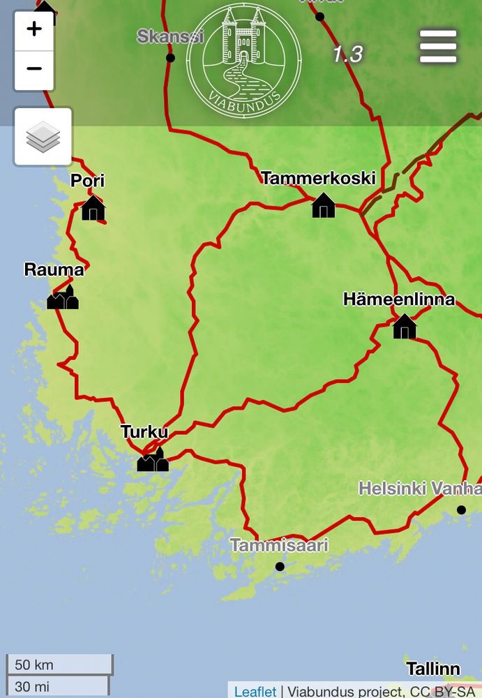
Huzzah! Viabundus 2.0 "St. George" is online! We invite you to play around with the updated routing tool and to explore the newly added Finnish roads! www.viabundus.eu
April 25, 2025 at 3:48 PM
Huzzah! Viabundus 2.0 "St. George" is online! We invite you to play around with the updated routing tool and to explore the newly added Finnish roads! www.viabundus.eu
There it is: The Viabundus Update 2.0 including the new dataset created by the team of Viabundus Finland!
We celebrate the news with a two-hour virtual event packed with short presentations on Friday, April 25, 10-12 CEST.
Find the programme and the registration here: s.academiccloud.de/FstqOZ
We celebrate the news with a two-hour virtual event packed with short presentations on Friday, April 25, 10-12 CEST.
Find the programme and the registration here: s.academiccloud.de/FstqOZ
April 12, 2025 at 1:29 PM
There it is: The Viabundus Update 2.0 including the new dataset created by the team of Viabundus Finland!
We celebrate the news with a two-hour virtual event packed with short presentations on Friday, April 25, 10-12 CEST.
Find the programme and the registration here: s.academiccloud.de/FstqOZ
We celebrate the news with a two-hour virtual event packed with short presentations on Friday, April 25, 10-12 CEST.
Find the programme and the registration here: s.academiccloud.de/FstqOZ
Thanks to a hint by Andy D., a new and curious user, a bug in the routing tool could be repaired. Everything is back to normal! (that is at least something considering the current state of things, eh?) If you encounter problems, please don't hesitate to drop us a message!

November 12, 2024 at 8:59 AM
Thanks to a hint by Andy D., a new and curious user, a bug in the routing tool could be repaired. Everything is back to normal! (that is at least something considering the current state of things, eh?) If you encounter problems, please don't hesitate to drop us a message!
Bluesky now has over 10 million users, and I was #2,470,700!

September 18, 2024 at 10:06 AM
Bluesky now has over 10 million users, and I was #2,470,700!
Imagining this session like 👇. Have to be there...

September 10, 2024 at 11:57 AM
Imagining this session like 👇. Have to be there...
Viabundus on the Road: Meet our PI Bart Holterman today in Washington D.C. at #DH2024 (dh2024.adho.org). In the panel "Grounding Truth: Critical and Data-Driven Approaches to the History of Travel" @rmidura.bsky.social and other @emdigit.bsky.social members discuss premodern spatial data. Fresh!

August 8, 2024 at 10:17 AM
Viabundus on the Road: Meet our PI Bart Holterman today in Washington D.C. at #DH2024 (dh2024.adho.org). In the panel "Grounding Truth: Critical and Data-Driven Approaches to the History of Travel" @rmidura.bsky.social and other @emdigit.bsky.social members discuss premodern spatial data. Fresh!
Our colleague @muntera.bsky.social presented viabundus at Universität Kassel. A question that always comes up in discussions is that of the impact of seasonality on speed and routes of travelling. It looks like this should be a topic for a future panel or workshop...

June 13, 2024 at 6:45 AM
Our colleague @muntera.bsky.social presented viabundus at Universität Kassel. A question that always comes up in discussions is that of the impact of seasonality on speed and routes of travelling. It looks like this should be a topic for a future panel or workshop...
More LOD have been added, thanks to the World Historical Gazetteer reconciliation feature. The Viabundus places will be included into the WHG this year soon.

March 20, 2024 at 10:11 PM
More LOD have been added, thanks to the World Historical Gazetteer reconciliation feature. The Viabundus places will be included into the WHG this year soon.
Inclusion of all towns in the Burgundian Netherlands as mapped by Jacob van Deventer
(16th c.) and collection of additional information in this region. Ongoing improvement of nodes and roads in the Netherlands and Denmark.
(16th c.) and collection of additional information in this region. Ongoing improvement of nodes and roads in the Netherlands and Denmark.

March 20, 2024 at 9:34 PM
Inclusion of all towns in the Burgundian Netherlands as mapped by Jacob van Deventer
(16th c.) and collection of additional information in this region. Ongoing improvement of nodes and roads in the Netherlands and Denmark.
(16th c.) and collection of additional information in this region. Ongoing improvement of nodes and roads in the Netherlands and Denmark.
The road networks of the German states Bavaria and Saxony, parts of the Czech Republic, and the former German province East Prussia (now predominantly located in the Russian oblast Kaliningrad) have been checked
for historical accuracy.
for historical accuracy.

March 20, 2024 at 9:30 PM
The road networks of the German states Bavaria and Saxony, parts of the Czech Republic, and the former German province East Prussia (now predominantly located in the Russian oblast Kaliningrad) have been checked
for historical accuracy.
for historical accuracy.
Additional roads were mapped in the historical principalities of Flanders and Brabant and the German states Hessen and Rheinland-Pfalz, thus
extending the mapped area southwards to Heidelberg.
extending the mapped area southwards to Heidelberg.

March 20, 2024 at 9:22 PM
Additional roads were mapped in the historical principalities of Flanders and Brabant and the German states Hessen and Rheinland-Pfalz, thus
extending the mapped area southwards to Heidelberg.
extending the mapped area southwards to Heidelberg.
The display and routing are much faster, as well. We migrated our database to PostgreSQL and are now using the pgrouting package.

March 20, 2024 at 9:10 PM
The display and routing are much faster, as well. We migrated our database to PostgreSQL and are now using the pgrouting package.
Viabundus 1.3 ("St. Gertrud") is online! The most notable new feature is, that you can include stations to your route, so you can better follow itineraries in your sources.

March 20, 2024 at 8:55 PM
Viabundus 1.3 ("St. Gertrud") is online! The most notable new feature is, that you can include stations to your route, so you can better follow itineraries in your sources.
In the Viabundus Map you can choose between two basemaps: the actual OSM and the naked terrain in green shades based on SRTM with recreated coastlines. Which one do you like or use more? That is: which should be the standard basemap?


March 13, 2024 at 10:26 PM
In the Viabundus Map you can choose between two basemaps: the actual OSM and the naked terrain in green shades based on SRTM with recreated coastlines. Which one do you like or use more? That is: which should be the standard basemap?
Coming up:
The Road Goes on - The international conference, hosted by the Viabundus Finland team in Tampere 16-17 Feb 2024. Register now for free to attend online or on site! Programme and info here: projects.tuni.fi/viabundus-fi...
The Road Goes on - The international conference, hosted by the Viabundus Finland team in Tampere 16-17 Feb 2024. Register now for free to attend online or on site! Programme and info here: projects.tuni.fi/viabundus-fi...

February 1, 2024 at 3:38 PM
Coming up:
The Road Goes on - The international conference, hosted by the Viabundus Finland team in Tampere 16-17 Feb 2024. Register now for free to attend online or on site! Programme and info here: projects.tuni.fi/viabundus-fi...
The Road Goes on - The international conference, hosted by the Viabundus Finland team in Tampere 16-17 Feb 2024. Register now for free to attend online or on site! Programme and info here: projects.tuni.fi/viabundus-fi...
A use of viabundus we barely thought of is research for a novel.
What is more painful? To travel long distances in the 17th century or to recreate their circumstances today?
Read more on writer Ilana deBare's blog: ilanadebare.substack.com/p/17th-century…
What is more painful? To travel long distances in the 17th century or to recreate their circumstances today?
Read more on writer Ilana deBare's blog: ilanadebare.substack.com/p/17th-century…

January 19, 2024 at 11:54 AM
A use of viabundus we barely thought of is research for a novel.
What is more painful? To travel long distances in the 17th century or to recreate their circumstances today?
Read more on writer Ilana deBare's blog: ilanadebare.substack.com/p/17th-century…
What is more painful? To travel long distances in the 17th century or to recreate their circumstances today?
Read more on writer Ilana deBare's blog: ilanadebare.substack.com/p/17th-century…
If I had a map that shows the roads for my time, or better, something interactive, and with a calculator of travel times. Look no further! We are developing a source based, profoundly researched map of the main road network in Northern Europe between 1350 and 1650. Play around: www.viabundus.eu

December 11, 2023 at 7:03 PM
If I had a map that shows the roads for my time, or better, something interactive, and with a calculator of travel times. Look no further! We are developing a source based, profoundly researched map of the main road network in Northern Europe between 1350 and 1650. Play around: www.viabundus.eu