


Keah
@keah.bsky.social
Meteorology professor in Denver, backyard dahlia grower, cheesehead living in Colorado
Reposted by Keah

TIL about a memorial ceremony in Iceland in 2019 to mark the end of a glacier, changing the place name from Okjökull to Ok (jökull = glacier). Uncompromising wording on the bronze plaque:
"This is to acknowledge that we know what is happening and what needs to be done. Only you know if we did it".
"This is to acknowledge that we know what is happening and what needs to be done. Only you know if we did it".

December 7, 2025 at 5:17 PM
TIL about a memorial ceremony in Iceland in 2019 to mark the end of a glacier, changing the place name from Okjökull to Ok (jökull = glacier). Uncompromising wording on the bronze plaque:
"This is to acknowledge that we know what is happening and what needs to be done. Only you know if we did it".
"This is to acknowledge that we know what is happening and what needs to be done. Only you know if we did it".
Reposted by Keah

Deadliest tropical cyclone of 2025: A rare low-latitude tropical storm (Senyar, which formed at 3.7N) contributed to flooding in Indonesia, Thailand, and Malaysia that has killed 775+ and left 430+ missing. Lhokseumawe, Indonesia had 15.12" (384 mm) of rain in 24h ending 12Z Nov. 26.

Indonesia floods death toll rises to 442 as people hunt for food and water
At least two areas of the worst-affected Sumatra island still unreachable, as authorities struggle to deliver aid.
www.aljazeera.com
December 1, 2025 at 1:04 AM
Deadliest tropical cyclone of 2025: A rare low-latitude tropical storm (Senyar, which formed at 3.7N) contributed to flooding in Indonesia, Thailand, and Malaysia that has killed 775+ and left 430+ missing. Lhokseumawe, Indonesia had 15.12" (384 mm) of rain in 24h ending 12Z Nov. 26.
Reposted by Keah

🔥Let's check in and see how much December temperatures have changed (trend) over the last 75 years. 🔥

December 1, 2025 at 8:17 PM
🔥Let's check in and see how much December temperatures have changed (trend) over the last 75 years. 🔥
Reposted by Keah

Temperature anomalies across the #Arctic over the last 12 months...
Data from @copernicusecmwf.bsky.social ERA5 reanalysis.
Data from @copernicusecmwf.bsky.social ERA5 reanalysis.

December 1, 2025 at 12:37 PM
Temperature anomalies across the #Arctic over the last 12 months...
Data from @copernicusecmwf.bsky.social ERA5 reanalysis.
Data from @copernicusecmwf.bsky.social ERA5 reanalysis.
Reposted by Keah
After 9 straight years with a landfalling hurricane—and a record 5 straight (2020-2024) with a major hurricane landfall—the U.S. escaped any hurricane landfalls in 2025. With the unprecedented disarray affecting FEMA and NOAA, we were extremely fortunate not to be tested by a major hurricane!

A Cat 4 and 5 extravaganza: A look back at the 2025 Atlantic hurricane season » Yale Climate Connections
Extraordinarily, three of 2025’s 13 named storms (23%) reached Category 5 strength: Erin, Humberto, and Melissa.
yaleclimateconnections.org
December 1, 2025 at 2:52 PM
After 9 straight years with a landfalling hurricane—and a record 5 straight (2020-2024) with a major hurricane landfall—the U.S. escaped any hurricane landfalls in 2025. With the unprecedented disarray affecting FEMA and NOAA, we were extremely fortunate not to be tested by a major hurricane!
Reposted by Keah
🔥🔥🔥 Fall (Sep-Nov) was the 3rd warmest on record for the Contiguous U.S. (2016 & 2024 tied for 1st/2nd). 🔥🔥🔥

December 1, 2025 at 4:09 PM
🔥🔥🔥 Fall (Sep-Nov) was the 3rd warmest on record for the Contiguous U.S. (2016 & 2024 tied for 1st/2nd). 🔥🔥🔥
Reposted by Keah
🚨 Monday ice update - #Arctic sea ice extent is currently the lowest on record (JAXA data)
• about 1,110,000 km² below the 2010s mean
• about 1,600,000 km² below the 2000s mean
• about 2,310,000 km² below the 1990s mean
• about 2,810,000 km² below the 1980s mean
More: zacklabe.com/arctic-sea-i...
• about 1,110,000 km² below the 2010s mean
• about 1,600,000 km² below the 2000s mean
• about 2,310,000 km² below the 1990s mean
• about 2,810,000 km² below the 1980s mean
More: zacklabe.com/arctic-sea-i...

December 1, 2025 at 4:04 PM
🚨 Monday ice update - #Arctic sea ice extent is currently the lowest on record (JAXA data)
• about 1,110,000 km² below the 2010s mean
• about 1,600,000 km² below the 2000s mean
• about 2,310,000 km² below the 1990s mean
• about 2,810,000 km² below the 1980s mean
More: zacklabe.com/arctic-sea-i...
• about 1,110,000 km² below the 2010s mean
• about 1,600,000 km² below the 2000s mean
• about 2,310,000 km² below the 1990s mean
• about 2,810,000 km² below the 1980s mean
More: zacklabe.com/arctic-sea-i...
Reposted by Keah
Monday ice update - #Arctic sea ice extent is currently the *2nd* lowest on record (JAXA data)
• about 740,000 km² below the 2010s mean
• about 1,390,000 km² below the 2000s mean
• about 2,030,000 km² below the 1990s mean
• about 2,490,000 km² below the 1980s mean
More zacklabe.com/arctic-sea-i...
• about 740,000 km² below the 2010s mean
• about 1,390,000 km² below the 2000s mean
• about 2,030,000 km² below the 1990s mean
• about 2,490,000 km² below the 1980s mean
More zacklabe.com/arctic-sea-i...

November 17, 2025 at 1:34 PM
Monday ice update - #Arctic sea ice extent is currently the *2nd* lowest on record (JAXA data)
• about 740,000 km² below the 2010s mean
• about 1,390,000 km² below the 2000s mean
• about 2,030,000 km² below the 1990s mean
• about 2,490,000 km² below the 1980s mean
More zacklabe.com/arctic-sea-i...
• about 740,000 km² below the 2010s mean
• about 1,390,000 km² below the 2000s mean
• about 2,030,000 km² below the 1990s mean
• about 2,490,000 km² below the 1980s mean
More zacklabe.com/arctic-sea-i...


Reposted by Keah
📣 We just released a new free resource at @climatecentral.org - a 72-slide deck introducing key facts about climate change, including its causes, impacts, and solutions. It also comes with speaker notes and links for local storytelling.
➡️ www.climatecentral.org/climate-matt... (English & Spanish)
➡️ www.climatecentral.org/climate-matt... (English & Spanish)
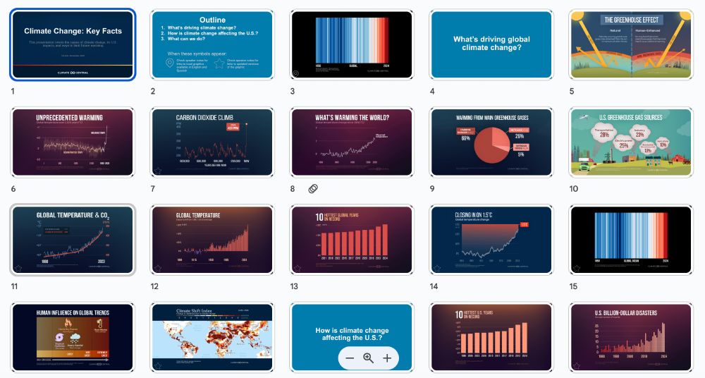
November 10, 2025 at 12:52 PM
📣 We just released a new free resource at @climatecentral.org - a 72-slide deck introducing key facts about climate change, including its causes, impacts, and solutions. It also comes with speaker notes and links for local storytelling.
➡️ www.climatecentral.org/climate-matt... (English & Spanish)
➡️ www.climatecentral.org/climate-matt... (English & Spanish)
Reposted by Keah
Fung-wong the 4th major landfalling typhoon of 2025:
Danas (Cat 3, Taiwan)
Ragasa (Cat 5, Panuitan Island, Philippines)
Kalmaegi (Cat 3, Vietnam)
Fung-wong (Cat 3, Philippines)
No long-term trend since 1946, but the 2004-2025 period has seen a lot (4.2/y) vs. the previous 22-year period (2.6/y).
Danas (Cat 3, Taiwan)
Ragasa (Cat 5, Panuitan Island, Philippines)
Kalmaegi (Cat 3, Vietnam)
Fung-wong (Cat 3, Philippines)
No long-term trend since 1946, but the 2004-2025 period has seen a lot (4.2/y) vs. the previous 22-year period (2.6/y).

November 10, 2025 at 4:30 PM
Fung-wong the 4th major landfalling typhoon of 2025:
Danas (Cat 3, Taiwan)
Ragasa (Cat 5, Panuitan Island, Philippines)
Kalmaegi (Cat 3, Vietnam)
Fung-wong (Cat 3, Philippines)
No long-term trend since 1946, but the 2004-2025 period has seen a lot (4.2/y) vs. the previous 22-year period (2.6/y).
Danas (Cat 3, Taiwan)
Ragasa (Cat 5, Panuitan Island, Philippines)
Kalmaegi (Cat 3, Vietnam)
Fung-wong (Cat 3, Philippines)
No long-term trend since 1946, but the 2004-2025 period has seen a lot (4.2/y) vs. the previous 22-year period (2.6/y).
Reposted by Keah

NEW: Devastating imagery from Jamaica, before & after Category 5 Hurricane Melissa.
Black River — near total destruction.
Black River — near total destruction.
October 29, 2025 at 8:28 PM
NEW: Devastating imagery from Jamaica, before & after Category 5 Hurricane Melissa.
Black River — near total destruction.
Black River — near total destruction.
Reposted by Keah

Melissa at 892 mb. Since 1966, only 4 other North Atlantic hurricanes reached surface pressures below 900 mb (unit equal to hPa). Maximum winds at those pressures also listed below:
Wilma (2005): 160 kt, 882 mb
Gilbert (1988): 160 kt, 888 mb
Rita (2005): 155 kt, 897 mb
Allen (1980): 165 kt, 899 mb
Wilma (2005): 160 kt, 882 mb
Gilbert (1988): 160 kt, 888 mb
Rita (2005): 155 kt, 897 mb
Allen (1980): 165 kt, 899 mb

Finally a dropsonde message got out. 892mb.
Lightning continues across much of the western semicircle.
Lightning continues across much of the western semicircle.

October 28, 2025 at 1:53 PM
Melissa at 892 mb. Since 1966, only 4 other North Atlantic hurricanes reached surface pressures below 900 mb (unit equal to hPa). Maximum winds at those pressures also listed below:
Wilma (2005): 160 kt, 882 mb
Gilbert (1988): 160 kt, 888 mb
Rita (2005): 155 kt, 897 mb
Allen (1980): 165 kt, 899 mb
Wilma (2005): 160 kt, 882 mb
Gilbert (1988): 160 kt, 888 mb
Rita (2005): 155 kt, 897 mb
Allen (1980): 165 kt, 899 mb
Reposted by Keah

Melissa Records:
Strongest Atlantic Landfall (Tie)
3rd Strongest Atlantic Hurricane (Tie)
World Record Driest/ Clearest Eye
3rd 2025 Cat 5 (2nd most)
4th Extreme Rapid Intensification Episide of 2025 (tied for 1st place)
1/
Strongest Atlantic Landfall (Tie)
3rd Strongest Atlantic Hurricane (Tie)
World Record Driest/ Clearest Eye
3rd 2025 Cat 5 (2nd most)
4th Extreme Rapid Intensification Episide of 2025 (tied for 1st place)
1/

October 28, 2025 at 10:25 PM
Melissa Records:
Strongest Atlantic Landfall (Tie)
3rd Strongest Atlantic Hurricane (Tie)
World Record Driest/ Clearest Eye
3rd 2025 Cat 5 (2nd most)
4th Extreme Rapid Intensification Episide of 2025 (tied for 1st place)
1/
Strongest Atlantic Landfall (Tie)
3rd Strongest Atlantic Hurricane (Tie)
World Record Driest/ Clearest Eye
3rd 2025 Cat 5 (2nd most)
4th Extreme Rapid Intensification Episide of 2025 (tied for 1st place)
1/
Reposted by Keah

From a crewmember on yesterday's Teal 74 mission into now-Category 5 Hurricane #Melissa. As clear of an eye as you will see in the Atlantic basin.
October 27, 2025 at 4:11 PM
From a crewmember on yesterday's Teal 74 mission into now-Category 5 Hurricane #Melissa. As clear of an eye as you will see in the Atlantic basin.
Reposted by Keah
I am at a loss for words as I watch Hurricane Melissa continue intensifying today. I'm thinking of the many folks in its path who will face compound flooding and wind hazards over an extended period of time.
(Animation shows 1-minute GOES mesoscale imagery since sunrise on October 27.)
(Animation shows 1-minute GOES mesoscale imagery since sunrise on October 27.)
October 27, 2025 at 5:55 PM
I am at a loss for words as I watch Hurricane Melissa continue intensifying today. I'm thinking of the many folks in its path who will face compound flooding and wind hazards over an extended period of time.
(Animation shows 1-minute GOES mesoscale imagery since sunrise on October 27.)
(Animation shows 1-minute GOES mesoscale imagery since sunrise on October 27.)
Reposted by Keah
As of October 20, water in excess of 30°C extended 60 meters below Tropical Storm Melissa.
A slow-moving storm will upwell water (bring deeper water up to the surface) because its winds are actively pushing surface water away, but these Argo float observations show that deeper water is also warm!
A slow-moving storm will upwell water (bring deeper water up to the surface) because its winds are actively pushing surface water away, but these Argo float observations show that deeper water is also warm!

October 23, 2025 at 3:32 PM
As of October 20, water in excess of 30°C extended 60 meters below Tropical Storm Melissa.
A slow-moving storm will upwell water (bring deeper water up to the surface) because its winds are actively pushing surface water away, but these Argo float observations show that deeper water is also warm!
A slow-moving storm will upwell water (bring deeper water up to the surface) because its winds are actively pushing surface water away, but these Argo float observations show that deeper water is also warm!
Reposted by Keah

The ocean under #Melissa is not only extremely warm, but that warm water extends very deep, resulting in huge values of ocean heat content. The storm could sit stationary for days and still not upwell cooler water. This is a powder keg that's able to deliver endless fuel to a hurricane.


October 23, 2025 at 4:26 PM
The ocean under #Melissa is not only extremely warm, but that warm water extends very deep, resulting in huge values of ocean heat content. The storm could sit stationary for days and still not upwell cooler water. This is a powder keg that's able to deliver endless fuel to a hurricane.
Reposted by Keah
Track and intensity of Typhoon/ex-typhoon Halong in early October. The storm passed over ocean water significantly warmer than normal for virtually its entire track, from southeast of Japan to landfall on the northeast Bering Sea coast. #akwx #weather #Climate #Alaska @climatologist49.bsky.social

October 22, 2025 at 7:14 PM
Track and intensity of Typhoon/ex-typhoon Halong in early October. The storm passed over ocean water significantly warmer than normal for virtually its entire track, from southeast of Japan to landfall on the northeast Bering Sea coast. #akwx #weather #Climate #Alaska @climatologist49.bsky.social
Reposted by Keah

The Billion Dollar Weather and Climate Disaster dataset is back and now at @climatecentral.org!
Through the first half of 2025, there were 14 separate billion-dollar weather and climate disasters across the United States, costing $101.4 billion. 1/2
www.climatecentral.org/climate-serv...
Through the first half of 2025, there were 14 separate billion-dollar weather and climate disasters across the United States, costing $101.4 billion. 1/2
www.climatecentral.org/climate-serv...

October 22, 2025 at 2:21 PM
The Billion Dollar Weather and Climate Disaster dataset is back and now at @climatecentral.org!
Through the first half of 2025, there were 14 separate billion-dollar weather and climate disasters across the United States, costing $101.4 billion. 1/2
www.climatecentral.org/climate-serv...
Through the first half of 2025, there were 14 separate billion-dollar weather and climate disasters across the United States, costing $101.4 billion. 1/2
www.climatecentral.org/climate-serv...
Reposted by Keah

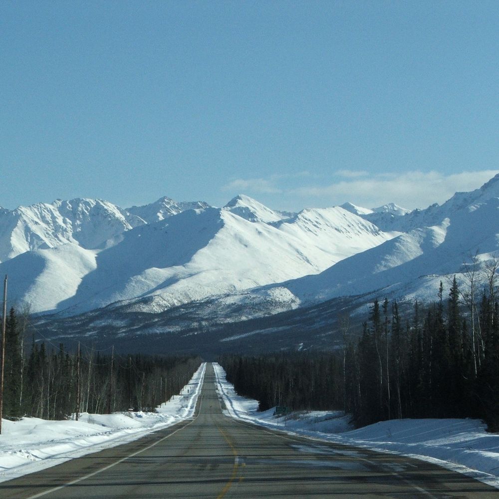
One of the largest airlift evacuations in Alaska history last week. Survivors may not be able to return home for 18 months — at least two coastal communities have been completely washed away by floodwaters from ex-Typhoon Halong.
www.usatoday.com/story/news/n...
www.usatoday.com/story/news/n...
October 20, 2025 at 3:51 PM
One of the largest airlift evacuations in Alaska history last week. Survivors may not be able to return home for 18 months — at least two coastal communities have been completely washed away by floodwaters from ex-Typhoon Halong.
www.usatoday.com/story/news/n...
www.usatoday.com/story/news/n...
Reposted by Keah

This is good reporting on the disaster in Alaska if you're looking for a reliable summary.
This is a bigger disaster than I think most are realizing. 1500 people have been displaced by the flooding with an exceptionally complicated response and recovery.
www.youtube.com/watch?v=t5kz...
This is a bigger disaster than I think most are realizing. 1500 people have been displaced by the flooding with an exceptionally complicated response and recovery.
www.youtube.com/watch?v=t5kz...

Rescue crews airlift hundreds out of rural Alaskan villages after powerful storm
YouTube video by PBS NewsHour
www.youtube.com
October 17, 2025 at 11:31 AM
This is good reporting on the disaster in Alaska if you're looking for a reliable summary.
This is a bigger disaster than I think most are realizing. 1500 people have been displaced by the flooding with an exceptionally complicated response and recovery.
www.youtube.com/watch?v=t5kz...
This is a bigger disaster than I think most are realizing. 1500 people have been displaced by the flooding with an exceptionally complicated response and recovery.
www.youtube.com/watch?v=t5kz...
Reposted by Keah

Increasing wildfire frequency decreases carbon storage and leads to regeneration failure in Alaskan boreal forests fireecology.springeropen.com/articles/10....
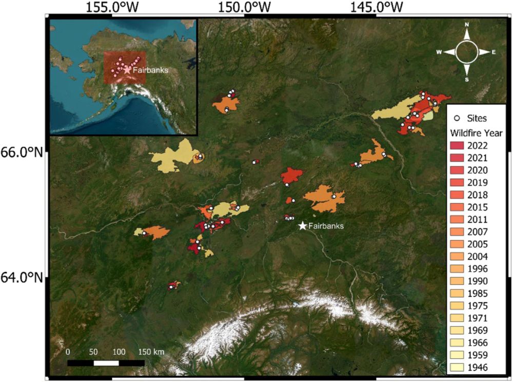
Increasing wildfire frequency decreases carbon storage and leads to regeneration failure in Alaskan boreal forests - Fire Ecology
Background The increasing size, severity, and frequency of wildfires is one of the most rapid ways climate warming could alter the structure and function of high-latitude ecosystems. Historically, boreal forests in western North America had fire return intervals (FRI) of 70–130 years, but shortened FRIs are becoming increasingly common under extreme weather conditions. Here, we quantified pre-fire and post-fire C pools and C losses and assessed post-fire seedling regeneration in long (> 70 years), intermediate (30–70 years), and short (< 30 years) FRIs, and triple (three fires in < 70 years) burns. As boreal forests store a significant portion of the global terrestrial carbon (C) pool, understanding the impacts of shortened FRIs on these ecosystems is critical for predicting the global C balance and feedbacks to climate. Results Using a spatially extensive dataset of 555 plots from 31 separate fires in Interior Alaska, our study demonstrates that shortened FRIs decrease the C storage capacity of boreal forests through loss of legacy C and regeneration failure. Total wildfire C emissions were similar among FRI classes, ranging from 2.5 to 3.5 kg C m−2. However, shortened FRIs lost proportionally more of their pre-fire C pools, resulting in substantially lower post-fire C pools than long FRIs. Shortened FRIs also resulted in the combustion of legacy C, defined as C that escaped combustion in one or more previous fires. We found that post-fire successional trajectories were impacted by FRI, with ~ 65% of short FRIs and triple burns experiencing regeneration failure. Conclusions Our study highlights the structural and functional vulnerability of boreal forests to increasing fire frequency. Shortened FRIs and the combustion of legacy C can shift boreal ecosystems from a net C sink or neutral to a net C source to the atmosphere and increase the risk of transitions to non-forested states. These changes could have profound implications for the boreal C-climate feedback and underscore the need for adaptive management strategies that prioritize the structural and functional resilience of boreal forest ecosystems to expected increases in fire frequency.
fireecology.springeropen.com
October 12, 2025 at 9:50 PM
Increasing wildfire frequency decreases carbon storage and leads to regeneration failure in Alaskan boreal forests fireecology.springeropen.com/articles/10....
Reposted by Keah
In contrast to the other side of the #Arctic, sea ice along the Atlantic front is a record low for this time of year. This relates to the recent record warmth and southerly winds/waves pushing the marginal ice zone closer to the North Pole.
Data from @nsidc.bsky.social (nsidc.org/data/seaice_...).
Data from @nsidc.bsky.social (nsidc.org/data/seaice_...).

October 13, 2025 at 12:05 PM
In contrast to the other side of the #Arctic, sea ice along the Atlantic front is a record low for this time of year. This relates to the recent record warmth and southerly winds/waves pushing the marginal ice zone closer to the North Pole.
Data from @nsidc.bsky.social (nsidc.org/data/seaice_...).
Data from @nsidc.bsky.social (nsidc.org/data/seaice_...).
Reposted by Keah

The remnants of Typhoon Halong appear to have potentially set a local ERA5 record (1950-2024) for lowest MSLP for the month of October:

October 13, 2025 at 1:11 AM
The remnants of Typhoon Halong appear to have potentially set a local ERA5 record (1950-2024) for lowest MSLP for the month of October: