


Joe Boomgard-Zagrodnik
@joeboomzag.bsky.social
Pacific Northwest weather/climate forecasts. Website: theconvergencezone.com
Reposted by Joe Boomgard-Zagrodnik

Grazalema, Spain, received over 2,000 mm (78 inches) of rain in just the last 20 days.
Over a year’s worth of rain — and it’s only early February. This is hydrologically absurd.
Over a year’s worth of rain — and it’s only early February. This is hydrologically absurd.

February 9, 2026 at 4:11 PM
Grazalema, Spain, received over 2,000 mm (78 inches) of rain in just the last 20 days.
Over a year’s worth of rain — and it’s only early February. This is hydrologically absurd.
Over a year’s worth of rain — and it’s only early February. This is hydrologically absurd.
In Seattle we take to the streets when our sports teams win. Until the “don’t walk” comes on. Then we take to the sidewalks.

So the intersection of SW Alaska and California Ave SW is a 4-way pedestrian signal — all cars stopped while fans rushed into the middle of the street with the walk sign and ran out when the red hand came back.
February 9, 2026 at 4:43 AM
In Seattle we take to the streets when our sports teams win. Until the “don’t walk” comes on. Then we take to the sidewalks.
Reposted by Joe Boomgard-Zagrodnik

How cold has this winter been so far? The first 2/3 of winter 2025-26 is the 7th warmest on record for the Contiguous U.S.

February 2, 2026 at 3:22 AM
How cold has this winter been so far? The first 2/3 of winter 2025-26 is the 7th warmest on record for the Contiguous U.S.
Reposted by Joe Boomgard-Zagrodnik

NCAR represents what is possible when a nation chooses to invest in science as a public good, writes @carlonimbus.bsky.social of @ucs.org. #SaveNCAR

What Americans Lose If Their National Center for Atmospheric Research Is Dismantled - Eos
Five ways dismantling NCAR will cost the American people, and two ways to save it.
eos.org
January 31, 2026 at 5:33 PM
NCAR represents what is possible when a nation chooses to invest in science as a public good, writes @carlonimbus.bsky.social of @ucs.org. #SaveNCAR
Reposted by Joe Boomgard-Zagrodnik

I've seen several Big Climate Accounts™ post about how the recent winter storm was made worse by climate change. It's a convenient narrative.
s
But what is "worse"? Colder temperatures? More snow? More freezing rain? Is there any primary literature supporting the idea of worse snowstorms?
1/
s
But what is "worse"? Colder temperatures? More snow? More freezing rain? Is there any primary literature supporting the idea of worse snowstorms?
1/
January 31, 2026 at 3:29 AM
I've seen several Big Climate Accounts™ post about how the recent winter storm was made worse by climate change. It's a convenient narrative.
s
But what is "worse"? Colder temperatures? More snow? More freezing rain? Is there any primary literature supporting the idea of worse snowstorms?
1/
s
But what is "worse"? Colder temperatures? More snow? More freezing rain? Is there any primary literature supporting the idea of worse snowstorms?
1/
My flight to Houston keeps getting canceled and each time Alaska’s auto rebook gives me a more complicated itinerary. I now have SEA->PDX->SEA->IAH which seems sub optimal…
January 25, 2026 at 5:13 AM
My flight to Houston keeps getting canceled and each time Alaska’s auto rebook gives me a more complicated itinerary. I now have SEA->PDX->SEA->IAH which seems sub optimal…
The cold/dry spell is nearly over for Seattle.
The next pattern shift will bring seasonal precipitation and above normal temperatures.
It will really feel like spring by the first week of February.
The mountain snowfall outlook is bleak.
The next pattern shift will bring seasonal precipitation and above normal temperatures.
It will really feel like spring by the first week of February.
The mountain snowfall outlook is bleak.

January 24, 2026 at 7:38 PM
The cold/dry spell is nearly over for Seattle.
The next pattern shift will bring seasonal precipitation and above normal temperatures.
It will really feel like spring by the first week of February.
The mountain snowfall outlook is bleak.
The next pattern shift will bring seasonal precipitation and above normal temperatures.
It will really feel like spring by the first week of February.
The mountain snowfall outlook is bleak.
Snowpack in Washington and Oregon is so bad that a normal February and March would result in a recovery to just the ~10th percentile of historical years. More in the CZ blog...
theconvergencezone.com/2026/01/19/p...
theconvergencezone.com/2026/01/19/p...

PNW snowpack approaches record lows
As we approach the halfway point of mountain snow season, snowpack remains in poor condition across much of the PNW. The state of the snowpack as measured by SNOTEL stations is often displayed as a…
theconvergencezone.com
January 19, 2026 at 6:16 PM
Snowpack in Washington and Oregon is so bad that a normal February and March would result in a recovery to just the ~10th percentile of historical years. More in the CZ blog...
theconvergencezone.com/2026/01/19/p...
theconvergencezone.com/2026/01/19/p...
The last 5-6 days of T/Td at my house had almost no diurnal cycle while we were stuck under an inversion.
Today the warmth aloft finally mixed down to the ground and the temp is soaring into the mid-50s.
Today the warmth aloft finally mixed down to the ground and the temp is soaring into the mid-50s.

January 16, 2026 at 9:24 PM
The last 5-6 days of T/Td at my house had almost no diurnal cycle while we were stuck under an inversion.
Today the warmth aloft finally mixed down to the ground and the temp is soaring into the mid-50s.
Today the warmth aloft finally mixed down to the ground and the temp is soaring into the mid-50s.
Reposted by Joe Boomgard-Zagrodnik

#EarthquakeReport for M 6.0 #Earthquake offshore of #Oregon #USA
Right-lateral strike-slip earthquake along Blanco transform fault
Common location for M 5-6+ earthquakes
No #Tsunami hazard
Tectonic setting in 2019 report earthjay.com?p=8935
earthquake.usgs.gov/earthquakes/...
Right-lateral strike-slip earthquake along Blanco transform fault
Common location for M 5-6+ earthquakes
No #Tsunami hazard
Tectonic setting in 2019 report earthjay.com?p=8935
earthquake.usgs.gov/earthquakes/...


January 16, 2026 at 4:30 AM
#EarthquakeReport for M 6.0 #Earthquake offshore of #Oregon #USA
Right-lateral strike-slip earthquake along Blanco transform fault
Common location for M 5-6+ earthquakes
No #Tsunami hazard
Tectonic setting in 2019 report earthjay.com?p=8935
earthquake.usgs.gov/earthquakes/...
Right-lateral strike-slip earthquake along Blanco transform fault
Common location for M 5-6+ earthquakes
No #Tsunami hazard
Tectonic setting in 2019 report earthjay.com?p=8935
earthquake.usgs.gov/earthquakes/...
Reposted by Joe Boomgard-Zagrodnik
Globally, no single day in 2025 was cooler than its 1991-2020 average.
climate.copernicus.eu/global-clima...
climate.copernicus.eu/global-clima...

January 14, 2026 at 12:44 PM
Globally, no single day in 2025 was cooler than its 1991-2020 average.
climate.copernicus.eu/global-clima...
climate.copernicus.eu/global-clima...
Reposted by Joe Boomgard-Zagrodnik

2025 was an exceptional year for the Earth's climate
⬆️ Warmest ocean heat content
⬆️ Tied as second warmest surface temps
⬆️ Second warmest troposphere
⬆️ Record high sea level and GHGs
⬇️ Record low winter Arctic ice
New State of the Climate over at Carbon Brief: www.carbonbrief.org/...
⬆️ Warmest ocean heat content
⬆️ Tied as second warmest surface temps
⬆️ Second warmest troposphere
⬆️ Record high sea level and GHGs
⬇️ Record low winter Arctic ice
New State of the Climate over at Carbon Brief: www.carbonbrief.org/...

January 14, 2026 at 2:53 PM
2025 was an exceptional year for the Earth's climate
⬆️ Warmest ocean heat content
⬆️ Tied as second warmest surface temps
⬆️ Second warmest troposphere
⬆️ Record high sea level and GHGs
⬇️ Record low winter Arctic ice
New State of the Climate over at Carbon Brief: www.carbonbrief.org/...
⬆️ Warmest ocean heat content
⬆️ Tied as second warmest surface temps
⬆️ Second warmest troposphere
⬆️ Record high sea level and GHGs
⬇️ Record low winter Arctic ice
New State of the Climate over at Carbon Brief: www.carbonbrief.org/...
Interesting 10 day forecast for Seattle with some ensemble members showing a cold snap and others projecting mild weather.
An arctic front is likely headed for the northern Plains/Rockies and the question is whether any of the arctic air will make it west of the Cascades or not.
An arctic front is likely headed for the northern Plains/Rockies and the question is whether any of the arctic air will make it west of the Cascades or not.


January 13, 2026 at 8:34 PM
Interesting 10 day forecast for Seattle with some ensemble members showing a cold snap and others projecting mild weather.
An arctic front is likely headed for the northern Plains/Rockies and the question is whether any of the arctic air will make it west of the Cascades or not.
An arctic front is likely headed for the northern Plains/Rockies and the question is whether any of the arctic air will make it west of the Cascades or not.
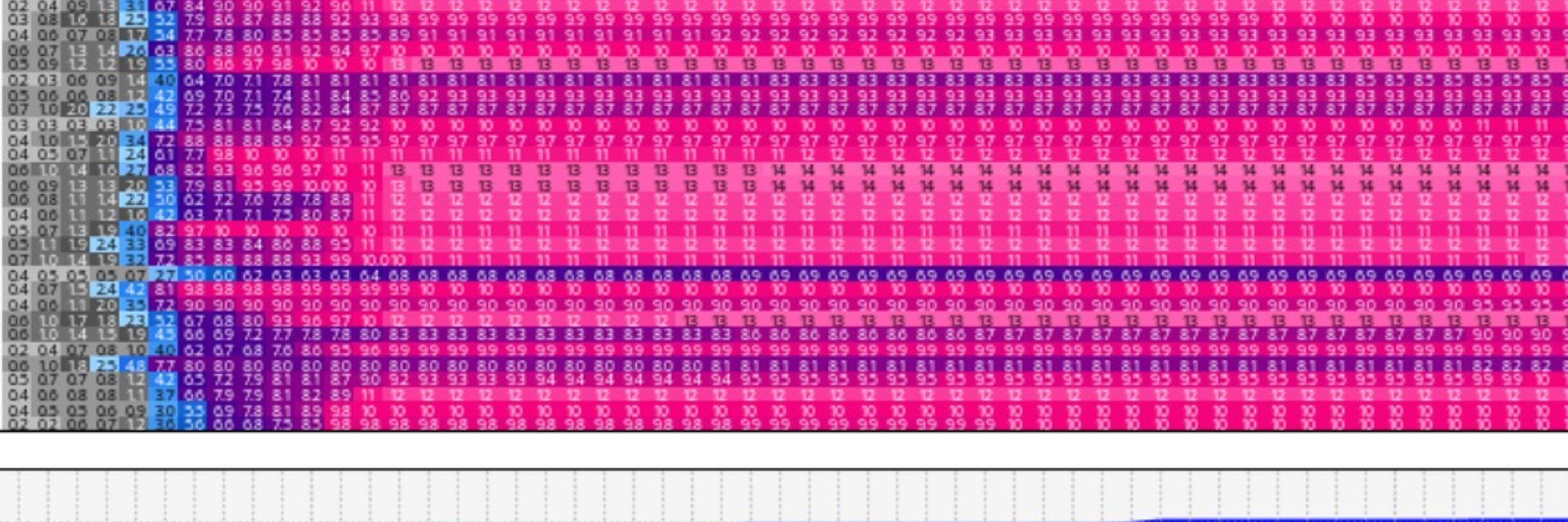
Same story for Washington (pictured) and Oregon.
Need 90th percentile snow from here on out to get to normal.
No snow coming anytime soon, so we'd need a record snowy Feb-Mar just to reach normal.
Hint: that ain't happening.
Need 90th percentile snow from here on out to get to normal.
No snow coming anytime soon, so we'd need a record snowy Feb-Mar just to reach normal.
Hint: that ain't happening.

January 13, 2026 at 7:44 PM
Same story for Washington (pictured) and Oregon.
Need 90th percentile snow from here on out to get to normal.
No snow coming anytime soon, so we'd need a record snowy Feb-Mar just to reach normal.
Hint: that ain't happening.
Need 90th percentile snow from here on out to get to normal.
No snow coming anytime soon, so we'd need a record snowy Feb-Mar just to reach normal.
Hint: that ain't happening.
One of those days in Seattle where you should probably cancel your afternoon meetings and take an extended lunch because it might be a while before we have sunshine and nearly 60 degree temperatures again.
(by the way, the record high for the date is 58)
(by the way, the record high for the date is 58)
January 13, 2026 at 6:37 PM
One of those days in Seattle where you should probably cancel your afternoon meetings and take an extended lunch because it might be a while before we have sunshine and nearly 60 degree temperatures again.
(by the way, the record high for the date is 58)
(by the way, the record high for the date is 58)
I can’t even causally read the news on a Sunday evening without there being another new crisis???
January 12, 2026 at 2:14 AM
I can’t even causally read the news on a Sunday evening without there being another new crisis???
I don’t comment much on non-weather current events but I read the content here and think what the actual fuck is going on in this country? How are we ever going to be able to turn this around when so many people support this and/or don’t know or care or have biased news feeds? It’s terrifying.
January 9, 2026 at 9:50 PM
I don’t comment much on non-weather current events but I read the content here and think what the actual fuck is going on in this country? How are we ever going to be able to turn this around when so many people support this and/or don’t know or care or have biased news feeds? It’s terrifying.
The Space Needle is in there somewhere

January 1, 2026 at 5:03 AM
The Space Needle is in there somewhere
Looks like we're going to need a miracle to be able to see anything at New Year's at the Space Needle this year...there's quite a bit of fog around and it will likely expand in coverage this evening 😶🌫️
January 1, 2026 at 12:41 AM
Looks like we're going to need a miracle to be able to see anything at New Year's at the Space Needle this year...there's quite a bit of fog around and it will likely expand in coverage this evening 😶🌫️
After a crazy December, there's not much PNW weather news to report.
A few weak weather systems will move through from Thursday night -> next week. Temperatures will be near-normal and precipitation will generally be light.
For mid-January, current odds favor a transition back to dry weather.
A few weak weather systems will move through from Thursday night -> next week. Temperatures will be near-normal and precipitation will generally be light.
For mid-January, current odds favor a transition back to dry weather.
December 30, 2025 at 10:53 PM
After a crazy December, there's not much PNW weather news to report.
A few weak weather systems will move through from Thursday night -> next week. Temperatures will be near-normal and precipitation will generally be light.
For mid-January, current odds favor a transition back to dry weather.
A few weak weather systems will move through from Thursday night -> next week. Temperatures will be near-normal and precipitation will generally be light.
For mid-January, current odds favor a transition back to dry weather.
Reposted by Joe Boomgard-Zagrodnik
🚨🔥 Warmest Christmas on record for the Contiguous U.S.! The average high of 57.9F and the average low of 36.6F each broke the Christmas record by a full 3F. 🔥🚨

December 26, 2025 at 3:39 PM
🚨🔥 Warmest Christmas on record for the Contiguous U.S.! The average high of 57.9F and the average low of 36.6F each broke the Christmas record by a full 3F. 🔥🚨
Fortunately for everyone, the wind storm didn‘t happen.
The European model had far and away the best forecasts for the event, although there were enough stronger members in the ensemble spread to trigger warnings/advisories.
The European model had far and away the best forecasts for the event, although there were enough stronger members in the ensemble spread to trigger warnings/advisories.

SEW cancels Wind Advisory for 21 forecast zones in [WA] Link

December 24, 2025 at 8:39 PM
Fortunately for everyone, the wind storm didn‘t happen.
The European model had far and away the best forecasts for the event, although there were enough stronger members in the ensemble spread to trigger warnings/advisories.
The European model had far and away the best forecasts for the event, although there were enough stronger members in the ensemble spread to trigger warnings/advisories.
I feel bad for the NAM model, it just wants one last time to shine before NOAA cuts the cord in 2026.
Fortunately it is 10-15+ years outdated and the modeled 70+ mph winds are NOT going to happen in Seattle.
Doesn't mean there won't be a significant storm, but not apocalypse level!
Fortunately it is 10-15+ years outdated and the modeled 70+ mph winds are NOT going to happen in Seattle.
Doesn't mean there won't be a significant storm, but not apocalypse level!
December 23, 2025 at 9:15 PM
I feel bad for the NAM model, it just wants one last time to shine before NOAA cuts the cord in 2026.
Fortunately it is 10-15+ years outdated and the modeled 70+ mph winds are NOT going to happen in Seattle.
Doesn't mean there won't be a significant storm, but not apocalypse level!
Fortunately it is 10-15+ years outdated and the modeled 70+ mph winds are NOT going to happen in Seattle.
Doesn't mean there won't be a significant storm, but not apocalypse level!
Will there be a Christmas Eve windstorm?
It would be nice to have an answer, but unfortunately the best meteorologists can do is say "maybe, maybe not".
I'd say it probably leans about 75/25 in favor of a minor event, so let's hope that ends up being the case.
It would be nice to have an answer, but unfortunately the best meteorologists can do is say "maybe, maybe not".
I'd say it probably leans about 75/25 in favor of a minor event, so let's hope that ends up being the case.

Will there be a windstorm in the PNW on Christmas Eve?
Forecasters are dealing with a tricky scenario over the next day as a potential windstorm with high forecast uncertainty takes aim at the PNW. As of Tuesday morning, NWS Seattle has high wind watch…
theconvergencezone.com
December 23, 2025 at 7:49 PM
Will there be a Christmas Eve windstorm?
It would be nice to have an answer, but unfortunately the best meteorologists can do is say "maybe, maybe not".
I'd say it probably leans about 75/25 in favor of a minor event, so let's hope that ends up being the case.
It would be nice to have an answer, but unfortunately the best meteorologists can do is say "maybe, maybe not".
I'd say it probably leans about 75/25 in favor of a minor event, so let's hope that ends up being the case.
Potential X-mas eve windstorm update --
The European model has a weaker and more inland low resulting in mostly non-damaging winds.
The GFS ensembles are stronger and farther west, resulting in an event that could be damaging for many areas.
Probably will come down to a nowcast 🤷
The European model has a weaker and more inland low resulting in mostly non-damaging winds.
The GFS ensembles are stronger and farther west, resulting in an event that could be damaging for many areas.
Probably will come down to a nowcast 🤷


December 23, 2025 at 6:27 PM
Potential X-mas eve windstorm update --
The European model has a weaker and more inland low resulting in mostly non-damaging winds.
The GFS ensembles are stronger and farther west, resulting in an event that could be damaging for many areas.
Probably will come down to a nowcast 🤷
The European model has a weaker and more inland low resulting in mostly non-damaging winds.
The GFS ensembles are stronger and farther west, resulting in an event that could be damaging for many areas.
Probably will come down to a nowcast 🤷