


a.s.
@wxandbiscuits.bsky.social
fire/tropical meteorologist. dogs, native plants and good food. georgia now but midwest is home. he/him/🏳️🌈. opinions my own.
Reposted by a.s.

Windy wildflowers and grasses.
Muhly grass and solidago line St George shoreline on Apalachicola bay
#scape #seascape #muhlygrass #solidago #wildflowers #bloomscrolling #winds
Muhly grass and solidago line St George shoreline on Apalachicola bay
#scape #seascape #muhlygrass #solidago #wildflowers #bloomscrolling #winds

November 15, 2025 at 12:54 AM
Windy wildflowers and grasses.
Muhly grass and solidago line St George shoreline on Apalachicola bay
#scape #seascape #muhlygrass #solidago #wildflowers #bloomscrolling #winds
Muhly grass and solidago line St George shoreline on Apalachicola bay
#scape #seascape #muhlygrass #solidago #wildflowers #bloomscrolling #winds
Reposted by a.s.

New paper out! We document tornado-strength (98 mph) counter-rotating vortices that developed within California’s 2021 #DixieFire. These fire-generated vortices reshaped the fire front and spread, posing immediate risks to firefighters and civilians. doi.org/10.1175/MWR-...

November 15, 2025 at 1:48 AM
New paper out! We document tornado-strength (98 mph) counter-rotating vortices that developed within California’s 2021 #DixieFire. These fire-generated vortices reshaped the fire front and spread, posing immediate risks to firefighters and civilians. doi.org/10.1175/MWR-...
Reposted by a.s.

It can get HOT in November, including today which saw temps soar close to 90 in SW OK. Getting closer to that all-time record high for the state of 95 set at Hollis back on Nov. 7, 2023 (also in Coalgate on Nov. 1, 1937). Tomorrow might be the day? #okwx #okmesonet


November 15, 2025 at 12:26 AM
It can get HOT in November, including today which saw temps soar close to 90 in SW OK. Getting closer to that all-time record high for the state of 95 set at Hollis back on Nov. 7, 2023 (also in Coalgate on Nov. 1, 1937). Tomorrow might be the day? #okwx #okmesonet
Reposted by a.s.

Robyn shares "Dopamine," first new single in 7 years www.brooklynvegan.com/robyn-shares...

Robyn shares "Dopamine," first new single in 7 years
"The doubleness of Dopamine is having an emotion that is super real, super strong..,and at the same time knowing that this is just a biological process in my body" - Robyn
www.brooklynvegan.com
November 12, 2025 at 6:51 PM
Robyn shares "Dopamine," first new single in 7 years www.brooklynvegan.com/robyn-shares...
Then USFS did a large firing operation on the Bald Mountain Fire today to bring it out to established containment lines - a wildfire effectively turned into a large prescribed fire. Still some risk for this to escape, with plenty of windy and dry days ahead of questionable rain later next week.


November 12, 2025 at 10:26 PM
Then USFS did a large firing operation on the Bald Mountain Fire today to bring it out to established containment lines - a wildfire effectively turned into a large prescribed fire. Still some risk for this to escape, with plenty of windy and dry days ahead of questionable rain later next week.
Reposted by a.s.

There are two noteworthy things about the latest NHC forecast for Melissa:
1. This is the first time NHC explicitly forecast rapid intensification at day 3-4 lead time
2. If latest forecast trends hold, this forecast could still be a significant intensity underestimate
1. This is the first time NHC explicitly forecast rapid intensification at day 3-4 lead time
2. If latest forecast trends hold, this forecast could still be a significant intensity underestimate

October 22, 2025 at 9:40 PM
There are two noteworthy things about the latest NHC forecast for Melissa:
1. This is the first time NHC explicitly forecast rapid intensification at day 3-4 lead time
2. If latest forecast trends hold, this forecast could still be a significant intensity underestimate
1. This is the first time NHC explicitly forecast rapid intensification at day 3-4 lead time
2. If latest forecast trends hold, this forecast could still be a significant intensity underestimate
Reposted by a.s.
On flights from Paris

Over 160 pounds of ketamine seized at Hartsfield-Jackson Atlanta airport, officials say

Over 160 pounds of ketamine seized at Hartsfield-Jackson Atlanta airport, officials say
Officers were able to stop smugglers from bringing in a massive amount of illegal substances through the airport.
www.atlantanewsfirst.com
October 21, 2025 at 5:07 PM
On flights from Paris
Reposted by a.s.

Why Tropical Storm Melissa is worth paying attention to - yes, even here in NYC: www.patreon.com/posts/why-tr...

Why Tropical Storm Melissa is worth paying attention to | New York Metro Weather
Get more from New York Metro Weather on Patreon
www.patreon.com
October 22, 2025 at 9:28 PM
Why Tropical Storm Melissa is worth paying attention to - yes, even here in NYC: www.patreon.com/posts/why-tr...
Melissa forecast by @pppapin.bsky.social at NHC to be a cat 4 by Monday. “Unfortunately, it is becoming increasingly likely that Melissa will become a large and dangerous hurricane by the end of the forecast period.”

October 22, 2025 at 9:13 PM
Melissa forecast by @pppapin.bsky.social at NHC to be a cat 4 by Monday. “Unfortunately, it is becoming increasingly likely that Melissa will become a large and dangerous hurricane by the end of the forecast period.”
Reposted by a.s.

The last 3 runs of the HAFSB model have been forecasting extreme rates of intensification for Tropical Storm Melissa beginning Sat. With Melissa traversing waters with large ocean heat content and shear lessening, this extreme intensification is within the realm of possibility.

October 22, 2025 at 7:58 PM
The last 3 runs of the HAFSB model have been forecasting extreme rates of intensification for Tropical Storm Melissa beginning Sat. With Melissa traversing waters with large ocean heat content and shear lessening, this extreme intensification is within the realm of possibility.
Fire activity is picking up today. Tomorrow may be worse in some of the Helene-impacted areas. Fingers crossed for that rain next week.

Persistant dry and breezy weather is creating favorable conditions for wildfire growth and spread across areas east of the Appalachians this week.


October 22, 2025 at 7:13 PM
Fire activity is picking up today. Tomorrow may be worse in some of the Helene-impacted areas. Fingers crossed for that rain next week.
Reposted by a.s.

"...Trump administration has promised to invest billions in AI initiatives. In response to an inquiry about why this program was cut, the Office of Management and Budget said in a statement that the program, quote, "wasted taxpayer funds to place climate change hysteria in AI models,"
WHAT?
WHAT?
October 22, 2025 at 4:02 PM
"...Trump administration has promised to invest billions in AI initiatives. In response to an inquiry about why this program was cut, the Office of Management and Budget said in a statement that the program, quote, "wasted taxpayer funds to place climate change hysteria in AI models,"
WHAT?
WHAT?
Love seeing a confidence indicator on WPC’s rainfall forecast for Melissa. The track uncertainty has huge implications for the degree of flooding across the Dominican Republic, Haiti, Cuba, Jamaica, the Bahamas and Turks & Caicos.

October 22, 2025 at 3:13 PM
Love seeing a confidence indicator on WPC’s rainfall forecast for Melissa. The track uncertainty has huge implications for the degree of flooding across the Dominican Republic, Haiti, Cuba, Jamaica, the Bahamas and Turks & Caicos.
Imagine some center reformations will occur the next few days, but the Air Force is finding Melissa’s low level circulation well removed from what is occurring aloft. Hard to buy the eastern solutions at this point.
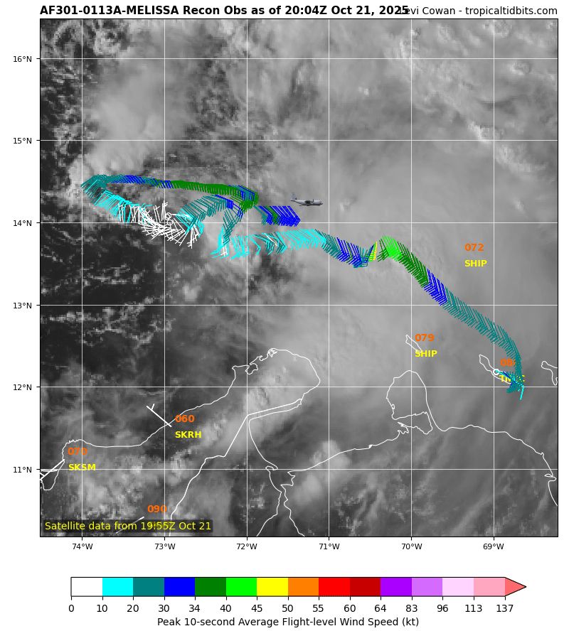
October 21, 2025 at 8:12 PM
Imagine some center reformations will occur the next few days, but the Air Force is finding Melissa’s low level circulation well removed from what is occurring aloft. Hard to buy the eastern solutions at this point.
Reposted by a.s.

'Another unoccupied house collapsed into the ocean along North Carolina's Outer Banks on Saturday night. It's the 11th house to collapse since mid-September.
In total, 22 homes have collapsed into the ocean in the area since 2020.'
via AccuWeather [X] #ClimateCrisis #SeaLevel
In total, 22 homes have collapsed into the ocean in the area since 2020.'
via AccuWeather [X] #ClimateCrisis #SeaLevel
October 20, 2025 at 11:04 PM
'Another unoccupied house collapsed into the ocean along North Carolina's Outer Banks on Saturday night. It's the 11th house to collapse since mid-September.
In total, 22 homes have collapsed into the ocean in the area since 2020.'
via AccuWeather [X] #ClimateCrisis #SeaLevel
In total, 22 homes have collapsed into the ocean in the area since 2020.'
via AccuWeather [X] #ClimateCrisis #SeaLevel
Easing into fall fire season over the Southeast this week.

The Storm Prediction Center issues Day 2 Fire Weather Outlook (Max Risk: Elevated) at Oct 21, 18:22z Link

October 21, 2025 at 6:28 PM
Easing into fall fire season over the Southeast this week.
Reposted by a.s.

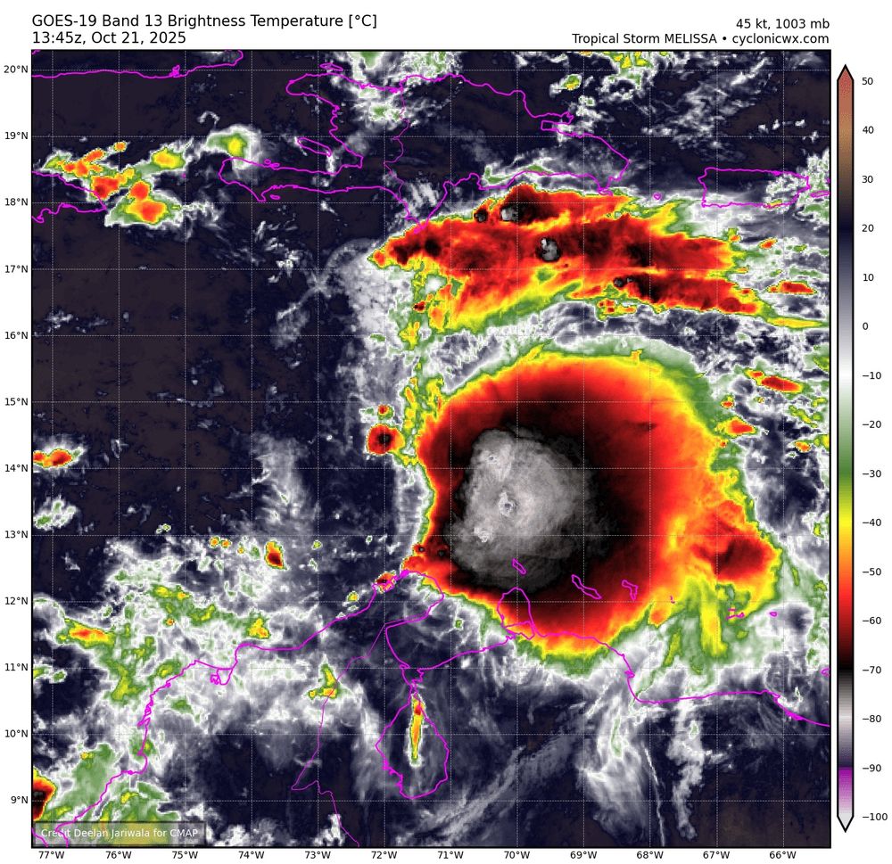
The ocean heat content is exceptionally high for this time of year across much of the Caribbean, so even a stalled storm will not be able to upwell cooler water from below. The Caribbean is famously an endless fuel source for hurricanes, and these huge anomalies only boost that further.
#Melissa
#Melissa

Melissa forms in Caribbean, forecast to intensify and stall over exceptionally warm water
Updates and summaries on tropical Atlantic activity... including easterly waves, tropical storms, subtropical storms, and hurricanes.
bmcnoldy.blogspot.com
October 21, 2025 at 5:25 PM
The ocean heat content is exceptionally high for this time of year across much of the Caribbean, so even a stalled storm will not be able to upwell cooler water from below. The Caribbean is famously an endless fuel source for hurricanes, and these huge anomalies only boost that further.
#Melissa
#Melissa
On flights from Paris
Over 160 pounds of ketamine seized at Hartsfield-Jackson Atlanta airport, officials say
Over 160 pounds of ketamine seized at Hartsfield-Jackson Atlanta airport, officials say
Officers were able to stop smugglers from bringing in a massive amount of illegal substances through the airport.
www.atlantanewsfirst.com
October 21, 2025 at 5:07 PM
On flights from Paris
Reposted by a.s.

NHC will initiate advisories on Tropical Storm Melissa (formerly AL98), located over the Caribbean Sea, at 1100 AM EDT (1500 UTC). https://x.com/NHC_Atlantic/status/1980637739553866070
October 21, 2025 at 2:15 PM
NHC will initiate advisories on Tropical Storm Melissa (formerly AL98), located over the Caribbean Sea, at 1100 AM EDT (1500 UTC). https://x.com/NHC_Atlantic/status/1980637739553866070
The NHC will initiate advisories on Tropical Storm Melissa at 1100 ET this morning.
October 21, 2025 at 1:57 PM
The NHC will initiate advisories on Tropical Storm Melissa at 1100 ET this morning.
The White House isn’t subject to the National Historic Preservation Act. Section 107: www.ntc.blm.gov/krc/system/f...
www.ntc.blm.gov
October 20, 2025 at 10:30 PM
The White House isn’t subject to the National Historic Preservation Act. Section 107: www.ntc.blm.gov/krc/system/f...
Good case for use of Potential Tropical Cyclone advisories this evening, even if the 5-day forecast is low confidence.

Uncertainty is high, but with only two to three days to prepare we must consider the potential for a tropical cyclone hitting Hispaniola this week. Sixty percent of models this morning indicate this. See DeepMind AI (FNV3), American GFS, European AI (AIFS), and US Navy. 1/


October 20, 2025 at 8:23 PM
Good case for use of Potential Tropical Cyclone advisories this evening, even if the 5-day forecast is low confidence.
Reposted by a.s.

Invest #98L is steadily getting better organized over the SE Caribbean today.
Fast low-level trade winds in the Caribbean "Graveyard" are the biggest impediment to development in the near-term.
Once #98L gets to ~75W where the trade winds are slower, much more rapid development is likely
Fast low-level trade winds in the Caribbean "Graveyard" are the biggest impediment to development in the near-term.
Once #98L gets to ~75W where the trade winds are slower, much more rapid development is likely


October 20, 2025 at 7:30 PM
Reposted by a.s.

The main event for the 2025 Atlantic hurricane season, as far as life-threatening impacts go, could well be unfolding in the Caribbean this week, as @bhensonweather.bsky.social and I explain: yaleclimateconnections.org/2025/10/trop...

Tropical disturbance poses torrential rainfall threat for the central Caribbean » Yale Climate Connections
No matter whether Invest 98L becomes a tropical storm later this week, it could lead to serious flooding.
yaleclimateconnections.org
October 20, 2025 at 4:41 PM
The main event for the 2025 Atlantic hurricane season, as far as life-threatening impacts go, could well be unfolding in the Caribbean this week, as @bhensonweather.bsky.social and I explain: yaleclimateconnections.org/2025/10/trop...