


Neil Lareau
@neillareau.bsky.social
Prof. of Atmos Sci. @unevadareno. Mountain WX, Wildfire Plumes, Backcountry Skiing, Frontcountry Dadding. Formerly: @SJSUmeteorology @UUtah
@Livermore_Lab @MWObs https://scholar.google.com/citations?user=UGaGnAgAAAAJ&hl=en
@Livermore_Lab @MWObs https://scholar.google.com/citations?user=UGaGnAgAAAAJ&hl=en
New paper out! We document tornado-strength (98 mph) counter-rotating vortices that developed within California’s 2021 #DixieFire. These fire-generated vortices reshaped the fire front and spread, posing immediate risks to firefighters and civilians. doi.org/10.1175/MWR-...

November 15, 2025 at 1:48 AM
New paper out! We document tornado-strength (98 mph) counter-rotating vortices that developed within California’s 2021 #DixieFire. These fire-generated vortices reshaped the fire front and spread, posing immediate risks to firefighters and civilians. doi.org/10.1175/MWR-...


Reposted by Neil Lareau

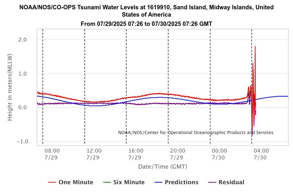
Water levels are fluctuating rapidly as the tsunami hits Midway Island, 1,200 miles northwest of Hawaii... wow.
July 30, 2025 at 4:36 AM
Water levels are fluctuating rapidly as the tsunami hits Midway Island, 1,200 miles northwest of Hawaii... wow.

Diverting money from science funding for immigration crack downs is dumb. Science funding provides enormous ROI. Deporting & intimidating unauthorized immigrants undermines the functioning and growth of our economy. In other words, you spend money to lose money, or negative ROI.
July 2, 2025 at 8:36 PM
Diverting money from science funding for immigration crack downs is dumb. Science funding provides enormous ROI. Deporting & intimidating unauthorized immigrants undermines the functioning and growth of our economy. In other words, you spend money to lose money, or negative ROI.
Reposted by Neil Lareau

Updated figure from Jain et al. showing global extreme fire weather trends since 1979. Metrics are global 95th percentile of annual Fire Weather Index (FWI), Initial Spread Index (ISI) and the Vapor Pressure Deficit (VPD). The trend is clear - we are seeing more extreme fire weather due to warming.

June 26, 2025 at 3:15 PM
Updated figure from Jain et al. showing global extreme fire weather trends since 1979. Metrics are global 95th percentile of annual Fire Weather Index (FWI), Initial Spread Index (ISI) and the Vapor Pressure Deficit (VPD). The trend is clear - we are seeing more extreme fire weather due to warming.
1/n: Still trying to understand the Lake Tahoe boating disaster from this past weekend. I like letting the data lead. Lets start with the radar, where I've added a red line annotating the clear, coherent wind shift associated with the front sagging south across the region.
June 25, 2025 at 12:39 AM
1/n: Still trying to understand the Lake Tahoe boating disaster from this past weekend. I like letting the data lead. Lets start with the radar, where I've added a red line annotating the clear, coherent wind shift associated with the front sagging south across the region.
Reposted by Neil Lareau

Visible & Infrared images from #GOES19/#GOESEast showed that the #TroutFire in New Mexico produced a #pyrocumulonimbus (pyroCb) cloud on 14 June - the first pyroCb in the US for the 2025. More on the CIMSS Satellite Blog: cimss.ssec.wisc.edu/satellite-bl... H/T @neillareau.bsky.social
June 16, 2025 at 12:13 AM
Visible & Infrared images from #GOES19/#GOESEast showed that the #TroutFire in New Mexico produced a #pyrocumulonimbus (pyroCb) cloud on 14 June - the first pyroCb in the US for the 2025. More on the CIMSS Satellite Blog: cimss.ssec.wisc.edu/satellite-bl... H/T @neillareau.bsky.social
Reposted by Neil Lareau
Total estimated emissions of 2025 Canadian #wildfires to 03/06 at ~50 MtC, comparable to 2023 record over same period, and increasing. #CopernicusAtmosphere Global Fire Assimilation System data based on MODIS🛰️ active fire obs ads.atmosphere.copernicus.eu/datasets/cam... @copernicusecmwf.bsky.social

June 4, 2025 at 9:43 AM
Total estimated emissions of 2025 Canadian #wildfires to 03/06 at ~50 MtC, comparable to 2023 record over same period, and increasing. #CopernicusAtmosphere Global Fire Assimilation System data based on MODIS🛰️ active fire obs ads.atmosphere.copernicus.eu/datasets/cam... @copernicusecmwf.bsky.social
More from today’s Rx burn:
June 4, 2025 at 12:57 AM
More from today’s Rx burn:
Reposted by Neil Lareau

Robust plumes of pyrocumulonimbus billow from wildfires in Alberta.
These were among many wildfires exhibiting extreme behavior yesterday across Canada.
These were among many wildfires exhibiting extreme behavior yesterday across Canada.
May 30, 2025 at 3:18 PM
Robust plumes of pyrocumulonimbus billow from wildfires in Alberta.
These were among many wildfires exhibiting extreme behavior yesterday across Canada.
These were among many wildfires exhibiting extreme behavior yesterday across Canada.
Reposted by Neil Lareau
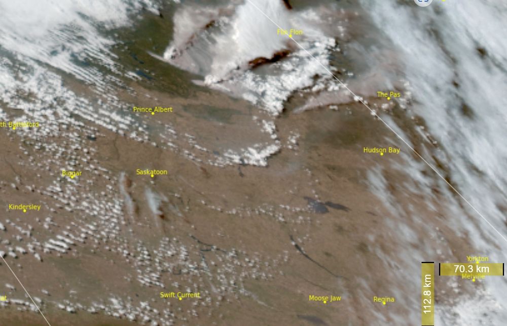
Massive smoke plumes from fires in Saskatchewan and Manitoba this evening. GOES East-geocolor loop below.
May 25, 2025 at 3:06 AM
Massive smoke plumes from fires in Saskatchewan and Manitoba this evening. GOES East-geocolor loop below.


Did you know that in 2021 the Dixie Fire yielded spot fires 10 miles from the fire front? Want to know how? My new paper examines the plume dynamics driving these extreme spotting events: agupubs.onlinelibrary.wiley.com/doi/10.1029/...

May 19, 2025 at 5:48 PM
Did you know that in 2021 the Dixie Fire yielded spot fires 10 miles from the fire front? Want to know how? My new paper examines the plume dynamics driving these extreme spotting events: agupubs.onlinelibrary.wiley.com/doi/10.1029/...
Reposted by Neil Lareau
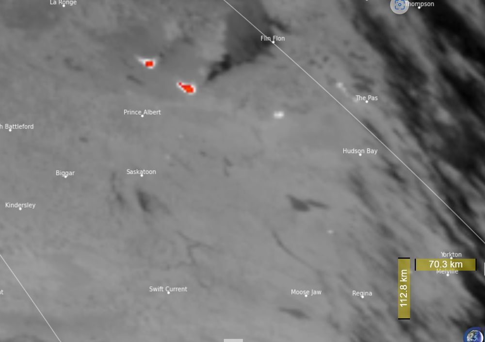
Active fires in Saskatchewan this afternoon. Mid-ir shows some very active fires (red/bright white) and a possible pyrocb (fire generated thunderstorm) in the GOES-West Geocolor.
May 8, 2025 at 11:45 PM
Active fires in Saskatchewan this afternoon. Mid-ir shows some very active fires (red/bright white) and a possible pyrocb (fire generated thunderstorm) in the GOES-West Geocolor.
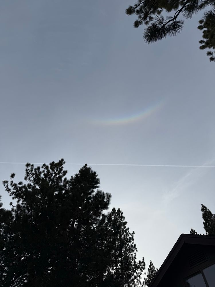
Circumzenithal arc.
April 25, 2025 at 1:16 AM
Circumzenithal arc.
Impressive fire activity today in New Jersey. Here is a 3D radar view of the plume structure from the #JonesFire during its peak fire intensity.
April 23, 2025 at 12:20 AM
Impressive fire activity today in New Jersey. Here is a 3D radar view of the plume structure from the #JonesFire during its peak fire intensity.
Cool example of preferential convection initiation on the snowy-to-snow-free boundary on the west slopes of the Sierra. Note the deeper cloud formation over the heated land as opposed to the snowpack (green).
April 2, 2025 at 11:15 PM
Cool example of preferential convection initiation on the snowy-to-snow-free boundary on the west slopes of the Sierra. Note the deeper cloud formation over the heated land as opposed to the snowpack (green).
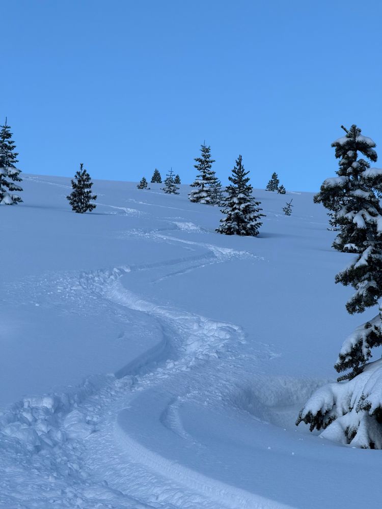
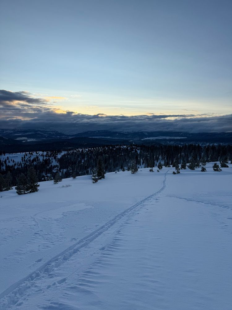
2+ ft of beautiful snow yesterday densified overnight, yielding excellent skiing this morning. Just wish I had more time!!
April 2, 2025 at 2:42 PM
2+ ft of beautiful snow yesterday densified overnight, yielding excellent skiing this morning. Just wish I had more time!!
Been an amazing day of #ShastaCountyConvergenceZone (SCCZ) activity.
March 27, 2025 at 10:25 PM
Been an amazing day of #ShastaCountyConvergenceZone (SCCZ) activity.
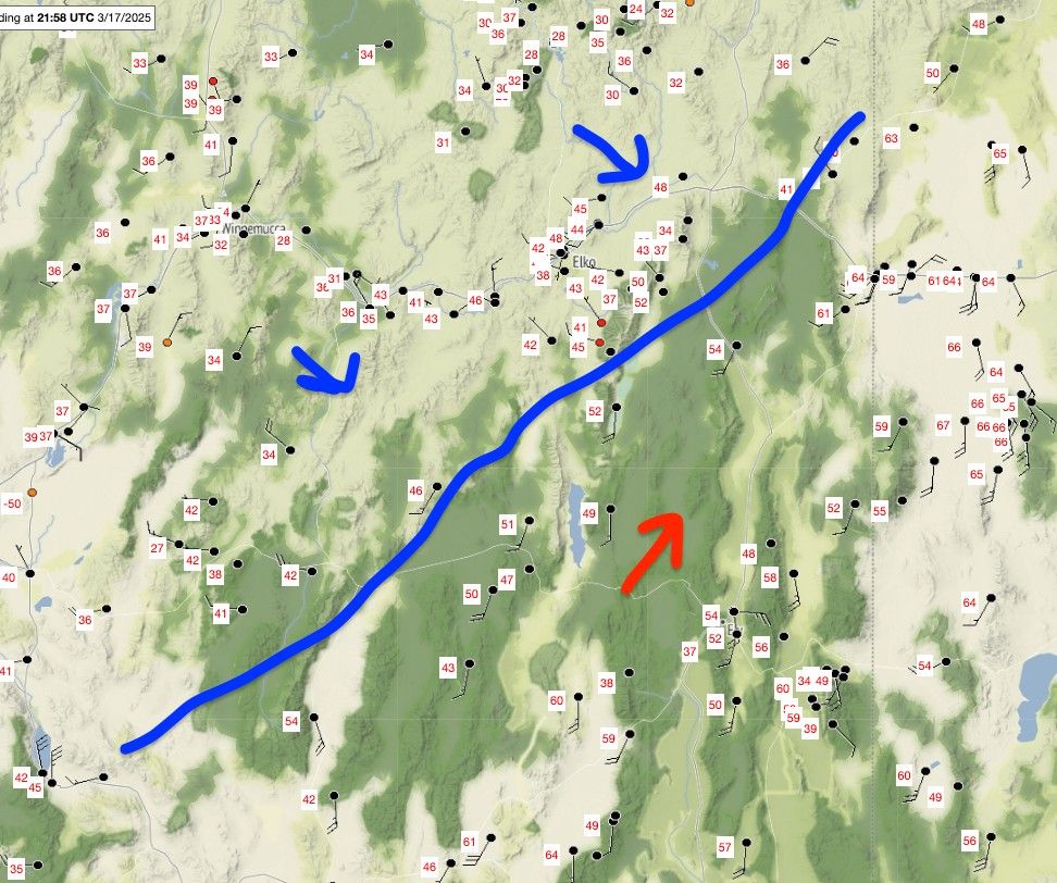
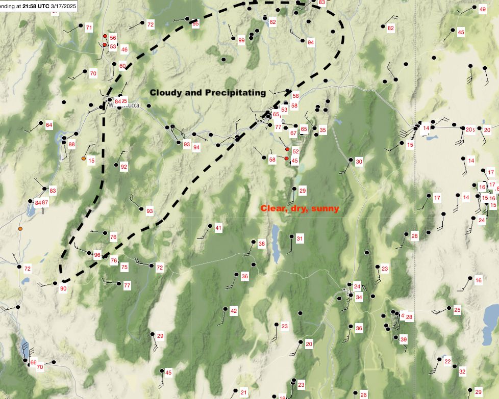
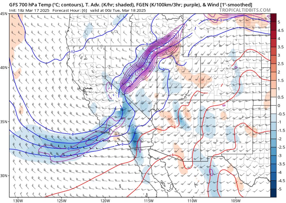
Classic early spring inter-mountain frontogenesis today: (1) Satellite image, (2) surface temperatures and rough diagram of the confluent region, (3) cross front diabatic heating differences helping to sharpen the front, (4) frontogenesis function (purple contours) from GFS.
March 17, 2025 at 10:09 PM
Classic early spring inter-mountain frontogenesis today: (1) Satellite image, (2) surface temperatures and rough diagram of the confluent region, (3) cross front diabatic heating differences helping to sharpen the front, (4) frontogenesis function (purple contours) from GFS.
Double barreled Shasta County Convergence Zone
March 17, 2025 at 1:54 AM
Double barreled Shasta County Convergence Zone
Fires (black dots) and plume (radar/green/blue) popping up amidst the blowing dust in Texas and Oklahoma. Could be ugly when the wind shift hits...
March 14, 2025 at 5:48 PM
Fires (black dots) and plume (radar/green/blue) popping up amidst the blowing dust in Texas and Oklahoma. Could be ugly when the wind shift hits...