


Anthony Edwards
@edwardsanthonyb.bsky.social
Newsroom Meteorologist at the San Francisco Chronicle
Snow lover, Seattle sports fan, University of Washington graduate
sfchronicle.com/author/anthony-edwards/
Snow lover, Seattle sports fan, University of Washington graduate
sfchronicle.com/author/anthony-edwards/
🌀 you spin me right round baby right round like an extratropical cyclone baby right round right round 🌀

February 15, 2026 at 11:21 PM
🌀 you spin me right round baby right round like an extratropical cyclone baby right round right round 🌀
The following table shows how "rare" the air mass is predicted to be over California on Wednesday morning. Temperatures at 5,000 feet are forecast to be around -4C (25F) over the Bay Area. This happens roughly once every other year. So it will certainly be cold! #CAwx

February 15, 2026 at 10:40 PM
The following table shows how "rare" the air mass is predicted to be over California on Wednesday morning. Temperatures at 5,000 feet are forecast to be around -4C (25F) over the Bay Area. This happens roughly once every other year. So it will certainly be cold! #CAwx
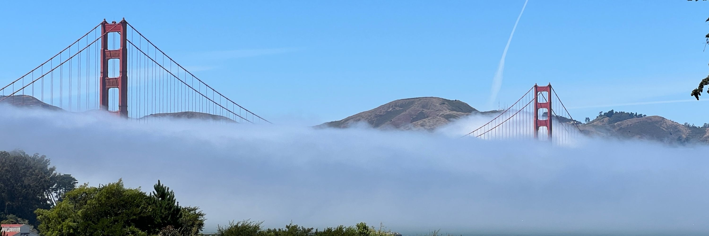
NEW: This week will bring the Bay Area's best chance of snow in three years as a series of cold storms sweep Northern California. #CAwx
www.sfchronicle.com/weather/arti...
www.sfchronicle.com/weather/arti...

Will it really snow in the Bay Area this week? Here’s the forecast
Mount Diablo is one of the Bay Area peaks forecast to experience freezing temperatures and a few inches of snow.
www.sfchronicle.com
February 15, 2026 at 8:49 PM
NEW: This week will bring the Bay Area's best chance of snow in three years as a series of cold storms sweep Northern California. #CAwx
www.sfchronicle.com/weather/arti...
www.sfchronicle.com/weather/arti...
Today is the last reasonable day for travel to/from the Sierra until at least Wednesday PM, potentially Friday. Even along the shoreline of Lake Tahoe, 3-4 ft of snow is expected. The weather service warns of MAJOR travel impacts Monday and EXTREME impacts Tuesday. Drive during today's sunshine.


February 15, 2026 at 5:10 PM
Today is the last reasonable day for travel to/from the Sierra until at least Wednesday PM, potentially Friday. Even along the shoreline of Lake Tahoe, 3-4 ft of snow is expected. The weather service warns of MAJOR travel impacts Monday and EXTREME impacts Tuesday. Drive during today's sunshine.
California is in the cross-hairs of back-to-back storms that are predicted to bring flooding rain, heavy snow, damaging wind, dangerous surf and even a chance of tornadoes to parts of the state. More areas than usual will see snow rather than just rain, especially from the second system.

California storms are about to hit. Here’s a timeline of their most severe impacts
California is in the crosshairs of back-to-back storms that will bring rain, flooding, heavy snow, high winds, dangerous surf and even a possible waterspout or tornado.
www.sfchronicle.com
February 15, 2026 at 2:23 PM
California is in the cross-hairs of back-to-back storms that are predicted to bring flooding rain, heavy snow, damaging wind, dangerous surf and even a chance of tornadoes to parts of the state. More areas than usual will see snow rather than just rain, especially from the second system.
The looming snowstorm will not wipe out the Sierra snow drought, but it'll put a dent into it.
The Truckee watershed needs 9.1 in. of snow water equivalent through Wednesday, Feb. 18 to reach median.
Carson: 6.3” SWE
Walker: 4.5” SWE
Warm temperatures, not a lack of precipitation, is the culprit
The Truckee watershed needs 9.1 in. of snow water equivalent through Wednesday, Feb. 18 to reach median.
Carson: 6.3” SWE
Walker: 4.5” SWE
Warm temperatures, not a lack of precipitation, is the culprit


February 14, 2026 at 7:12 PM
The looming snowstorm will not wipe out the Sierra snow drought, but it'll put a dent into it.
The Truckee watershed needs 9.1 in. of snow water equivalent through Wednesday, Feb. 18 to reach median.
Carson: 6.3” SWE
Walker: 4.5” SWE
Warm temperatures, not a lack of precipitation, is the culprit
The Truckee watershed needs 9.1 in. of snow water equivalent through Wednesday, Feb. 18 to reach median.
Carson: 6.3” SWE
Walker: 4.5” SWE
Warm temperatures, not a lack of precipitation, is the culprit
Lots of cold air filter in behind our looming California storm. Look at all of that cold air convection... clouds that resemble popcorn. This cold air clashing with warm air will favor the formation of a storm, scientifically known as cyclogensis. #CAwx

February 14, 2026 at 6:59 PM
Lots of cold air filter in behind our looming California storm. Look at all of that cold air convection... clouds that resemble popcorn. This cold air clashing with warm air will favor the formation of a storm, scientifically known as cyclogensis. #CAwx
Reposted by Anthony Edwards
Is it really going to snow in the Bay Area next week? 🧵
The coldest air mass since 2023 is forecast to move over the region Tuesday & Wednesday, dropping the freezing level below 3,000 feet. Snow can fall 500 to 1,000 feet below the freezing level and heavy showers can temporarily drag it lower.
The coldest air mass since 2023 is forecast to move over the region Tuesday & Wednesday, dropping the freezing level below 3,000 feet. Snow can fall 500 to 1,000 feet below the freezing level and heavy showers can temporarily drag it lower.


February 13, 2026 at 11:30 PM
Is it really going to snow in the Bay Area next week? 🧵
The coldest air mass since 2023 is forecast to move over the region Tuesday & Wednesday, dropping the freezing level below 3,000 feet. Snow can fall 500 to 1,000 feet below the freezing level and heavy showers can temporarily drag it lower.
The coldest air mass since 2023 is forecast to move over the region Tuesday & Wednesday, dropping the freezing level below 3,000 feet. Snow can fall 500 to 1,000 feet below the freezing level and heavy showers can temporarily drag it lower.
Reposted by Anthony Edwards

In his confirmation hearings, Robert F. Kennedy Jr. told U.S. senators that he would not cut funding for vaccine research or change the nation's official vaccine recommendations. He did both. n.pr/46QDn9p

RFK Jr. made promises to get his job as health secretary. He's broken many of them
In his confirmation hearings, Robert F. Kennedy Jr. told U.S. senators that he would not cut funding for vaccine research or change the nation's official vaccine recommendations. He did both.
n.pr
February 13, 2026 at 2:20 PM
In his confirmation hearings, Robert F. Kennedy Jr. told U.S. senators that he would not cut funding for vaccine research or change the nation's official vaccine recommendations. He did both. n.pr/46QDn9p
Reposted by Anthony Edwards
Hard to predict how inconsistent temperatures may affect almond bloom
“The chill sets you up, but you have to consider the different weather patterns at bloom time as well,” @ucanr.edu orchard advisor Franz Niederholzer told Ag Alert
www.agalert.com/california-a...
📸 @calebmhampton.bsky.social
“The chill sets you up, but you have to consider the different weather patterns at bloom time as well,” @ucanr.edu orchard advisor Franz Niederholzer told Ag Alert
www.agalert.com/california-a...
📸 @calebmhampton.bsky.social

February 13, 2026 at 8:47 PM
Hard to predict how inconsistent temperatures may affect almond bloom
“The chill sets you up, but you have to consider the different weather patterns at bloom time as well,” @ucanr.edu orchard advisor Franz Niederholzer told Ag Alert
www.agalert.com/california-a...
📸 @calebmhampton.bsky.social
“The chill sets you up, but you have to consider the different weather patterns at bloom time as well,” @ucanr.edu orchard advisor Franz Niederholzer told Ag Alert
www.agalert.com/california-a...
📸 @calebmhampton.bsky.social
Is it really going to snow in the Bay Area next week? 🧵
The coldest air mass since 2023 is forecast to move over the region Tuesday & Wednesday, dropping the freezing level below 3,000 feet. Snow can fall 500 to 1,000 feet below the freezing level and heavy showers can temporarily drag it lower.
The coldest air mass since 2023 is forecast to move over the region Tuesday & Wednesday, dropping the freezing level below 3,000 feet. Snow can fall 500 to 1,000 feet below the freezing level and heavy showers can temporarily drag it lower.
February 13, 2026 at 11:30 PM
Is it really going to snow in the Bay Area next week? 🧵
The coldest air mass since 2023 is forecast to move over the region Tuesday & Wednesday, dropping the freezing level below 3,000 feet. Snow can fall 500 to 1,000 feet below the freezing level and heavy showers can temporarily drag it lower.
The coldest air mass since 2023 is forecast to move over the region Tuesday & Wednesday, dropping the freezing level below 3,000 feet. Snow can fall 500 to 1,000 feet below the freezing level and heavy showers can temporarily drag it lower.
From @michaelemann.bsky.social in today's @sfchronicle.com:
On Thursday, the Environmental Protection Agency reversed its “endangerment finding," which found that greenhouse gases are a threat to human health. The latest actions will be costlier for Americans, rather than saving money.
On Thursday, the Environmental Protection Agency reversed its “endangerment finding," which found that greenhouse gases are a threat to human health. The latest actions will be costlier for Americans, rather than saving money.

Trump’s EPA can’t simply erase climate change — and we’ll all pay the price
On Thursday, the Environmental Protection Agency reversed its “endangerment finding," which found that greenhouse gases are a threat to human health.
www.sfchronicle.com
February 13, 2026 at 9:49 PM
From @michaelemann.bsky.social in today's @sfchronicle.com:
On Thursday, the Environmental Protection Agency reversed its “endangerment finding," which found that greenhouse gases are a threat to human health. The latest actions will be costlier for Americans, rather than saving money.
On Thursday, the Environmental Protection Agency reversed its “endangerment finding," which found that greenhouse gases are a threat to human health. The latest actions will be costlier for Americans, rather than saving money.
The National Weather Service warned of “very difficult to impossible” travel conditions in the Lake Tahoe area from Sunday evening through Wednesday evening as a cold, long-lasting storm was forecast to drop feet of snow Presidents’ Day weekend. Whiteout conditions were possible. #CAwx

Tahoe snowstorm could make travel ‘impossible,’ officials warn
A major winter storm moving in over the holiday weekend will vastly improve ski conditions but could make highways impassable.
www.sfchronicle.com
February 13, 2026 at 8:03 PM
The National Weather Service warned of “very difficult to impossible” travel conditions in the Lake Tahoe area from Sunday evening through Wednesday evening as a cold, long-lasting storm was forecast to drop feet of snow Presidents’ Day weekend. Whiteout conditions were possible. #CAwx
Reposted by Anthony Edwards

A frigid storm will sweep across California, lowering snow levels and creating dangerous Sierra and mountain travel conditions. Tahoe and Big Bear travel could turn treacherous by Monday.

California’s coldest storm of the season to hit holiday weekend. Here’s when travel turns risky
A frigid storm will sweep across California, lowering snow levels and creating dangerous Sierra and mountain travel conditions. Tahoe and Big Bear travel could turn treacherous by Monday.
bit.ly
February 13, 2026 at 2:00 PM
A frigid storm will sweep across California, lowering snow levels and creating dangerous Sierra and mountain travel conditions. Tahoe and Big Bear travel could turn treacherous by Monday.
Reposted by Anthony Edwards
Today's anti-science pairing

February 13, 2026 at 3:10 PM
Today's anti-science pairing
The coldest storms so far this winter are forecast to hit the Bay Area next week, potentially dropping the rain-snow line to 3,000 feet or lower. #CAwx

Onslaught of storms is headed to California — with chance of snow in Bay Area
An onslaught of California storms are predicted to bring heavy rain, breezy winds, big waves and the potential for low-elevation snow.
www.sfchronicle.com
February 12, 2026 at 6:22 PM
The coldest storms so far this winter are forecast to hit the Bay Area next week, potentially dropping the rain-snow line to 3,000 feet or lower. #CAwx
Forecast: wet
Brands of rain spiraling around an area of low pressure near Point Reyes. The heavy swath is nudging toward San Francisco. #CAwx
Brands of rain spiraling around an area of low pressure near Point Reyes. The heavy swath is nudging toward San Francisco. #CAwx
February 12, 2026 at 1:23 AM
Forecast: wet
Brands of rain spiraling around an area of low pressure near Point Reyes. The heavy swath is nudging toward San Francisco. #CAwx
Brands of rain spiraling around an area of low pressure near Point Reyes. The heavy swath is nudging toward San Francisco. #CAwx
A parade of storms is anticipated to bring 3 to 7 feet of snow to the Sierra Nevada as the atmosphere settles into a pattern favorable for back-to-back-to-back cold systems. It won’t be typical Sierra cement. Temperatures in the teens and 20s will be plenty cold for powdery snow that skiers crave.

California storms to bury Tahoe under feet of snow. Here’s when — and when not — to travel
A parade of storms is anticipated to bring 3 to 7 feet of powdery snow to the Sierra Nevada next week.
www.sfchronicle.com
February 11, 2026 at 8:47 PM
A parade of storms is anticipated to bring 3 to 7 feet of snow to the Sierra Nevada as the atmosphere settles into a pattern favorable for back-to-back-to-back cold systems. It won’t be typical Sierra cement. Temperatures in the teens and 20s will be plenty cold for powdery snow that skiers crave.
Reposted by Anthony Edwards

Sure, why not! A trio of waterspouts from some towering cumulus barely producing precipitation off of Santa Monica. 👀
Sounds more like the Florida Keys...but I guess that's what local ocean temperatures 5-6F warmer that average can achieve... #CAwx
Sounds more like the Florida Keys...but I guess that's what local ocean temperatures 5-6F warmer that average can achieve... #CAwx

At 12:48 PM PST, 8 WSW Marina del Rey [Pzz655 Co, CA] Lifeguard reports Waterspout. Hermosa Beach lifeguards observed 3 waterspouts about 10 miles off their coast to the west. They lasted for a few minutes before dissipating. #cawx Link

February 10, 2026 at 9:47 PM
Sure, why not! A trio of waterspouts from some towering cumulus barely producing precipitation off of Santa Monica. 👀
Sounds more like the Florida Keys...but I guess that's what local ocean temperatures 5-6F warmer that average can achieve... #CAwx
Sounds more like the Florida Keys...but I guess that's what local ocean temperatures 5-6F warmer that average can achieve... #CAwx
Reposted by Anthony Edwards
The top week 2 analog from CPC is eye-opening, as that week in 2017 burned more than 1.2 million acres in TX, OK and KS. The outcome will depend on details that aren’t yet clear, but drier trends this weekend could maintain receptive grasses into next week’s wind events.
February 10, 2026 at 6:25 PM
The top week 2 analog from CPC is eye-opening, as that week in 2017 burned more than 1.2 million acres in TX, OK and KS. The outcome will depend on details that aren’t yet clear, but drier trends this weekend could maintain receptive grasses into next week’s wind events.
The first significant rain since early January is approaching the Bay Area. Raindrops have begun in downtown San Francisco but the main swath of rain is still a couple hours away. It'll be a wet evening commute. #CAwx
Full forecast here: www.sfchronicle.com/weather-fore...
Full forecast here: www.sfchronicle.com/weather-fore...


February 10, 2026 at 8:36 PM
The first significant rain since early January is approaching the Bay Area. Raindrops have begun in downtown San Francisco but the main swath of rain is still a couple hours away. It'll be a wet evening commute. #CAwx
Full forecast here: www.sfchronicle.com/weather-fore...
Full forecast here: www.sfchronicle.com/weather-fore...
The EPA is set to roll back the endangerment finding, which is the foundational greenhouse gas regulation in the U.S. Humans are emitting planet-warming gasses more quickly than Earth can absorb. This energy imbalance is causing Earth's climate to change more rapidly than any time in history.

Trump set to gut US climate change policy and environmental regulations: White House official
A White House official says the Trump administration is expected this week to revoke a scientific finding that long has been the central basis for U.S. action to regulate greenhouse gas emissions and ...
apnews.com
February 10, 2026 at 5:14 PM
The EPA is set to roll back the endangerment finding, which is the foundational greenhouse gas regulation in the U.S. Humans are emitting planet-warming gasses more quickly than Earth can absorb. This energy imbalance is causing Earth's climate to change more rapidly than any time in history.
Reposted by Anthony Edwards

A group of conservative activists has worked for 16 years to stop all government efforts to fight climate change. Their efforts are now paying off.
The EPA is expected to revoke the endangerment finding, which has underpinned the government’s ability to fight global warming since 2009.
The EPA is expected to revoke the endangerment finding, which has underpinned the government’s ability to fight global warming since 2009.

A Campaign to Revoke the Endangerment Finding Appears Near ‘Total Victory’
A small group of conservative activists has worked for 16 years to stop all government efforts to fight climate change. Their efforts seem poised to pay off.
nyti.ms
February 10, 2026 at 1:25 PM
A group of conservative activists has worked for 16 years to stop all government efforts to fight climate change. Their efforts are now paying off.
The EPA is expected to revoke the endangerment finding, which has underpinned the government’s ability to fight global warming since 2009.
The EPA is expected to revoke the endangerment finding, which has underpinned the government’s ability to fight global warming since 2009.
Here's a look at the looming California storm that "bombed out" over the Pacific Ocean last night. The storm will bring the state its first significant rain and snow in five weeks. #CAwx

February 10, 2026 at 4:56 PM
Here's a look at the looming California storm that "bombed out" over the Pacific Ocean last night. The storm will bring the state its first significant rain and snow in five weeks. #CAwx
💣 Bomb cyclone?
At 12z (5am PST) Monday @nws.noaa.gov Ocean Prediction Center analyzed the storm's central barometric pressure at 1023 millibars. Latest forecast has it deepening to 998mb at at 12z (5am PST) Tuesday. That would exceed the threshold for bombogenesis!
At 12z (5am PST) Monday @nws.noaa.gov Ocean Prediction Center analyzed the storm's central barometric pressure at 1023 millibars. Latest forecast has it deepening to 998mb at at 12z (5am PST) Tuesday. That would exceed the threshold for bombogenesis!


February 9, 2026 at 10:25 PM
💣 Bomb cyclone?
At 12z (5am PST) Monday @nws.noaa.gov Ocean Prediction Center analyzed the storm's central barometric pressure at 1023 millibars. Latest forecast has it deepening to 998mb at at 12z (5am PST) Tuesday. That would exceed the threshold for bombogenesis!
At 12z (5am PST) Monday @nws.noaa.gov Ocean Prediction Center analyzed the storm's central barometric pressure at 1023 millibars. Latest forecast has it deepening to 998mb at at 12z (5am PST) Tuesday. That would exceed the threshold for bombogenesis!