


Mika Rantanen
@mikarantane.bsky.social
Researcher in Finnish Meteorological Institute. Climate change, extreme weather, and attribution of extreme events. PhD in meteorology in University of Helsinki.
Pinned
Mika Rantanen
@mikarantane.bsky.social
· Apr 28
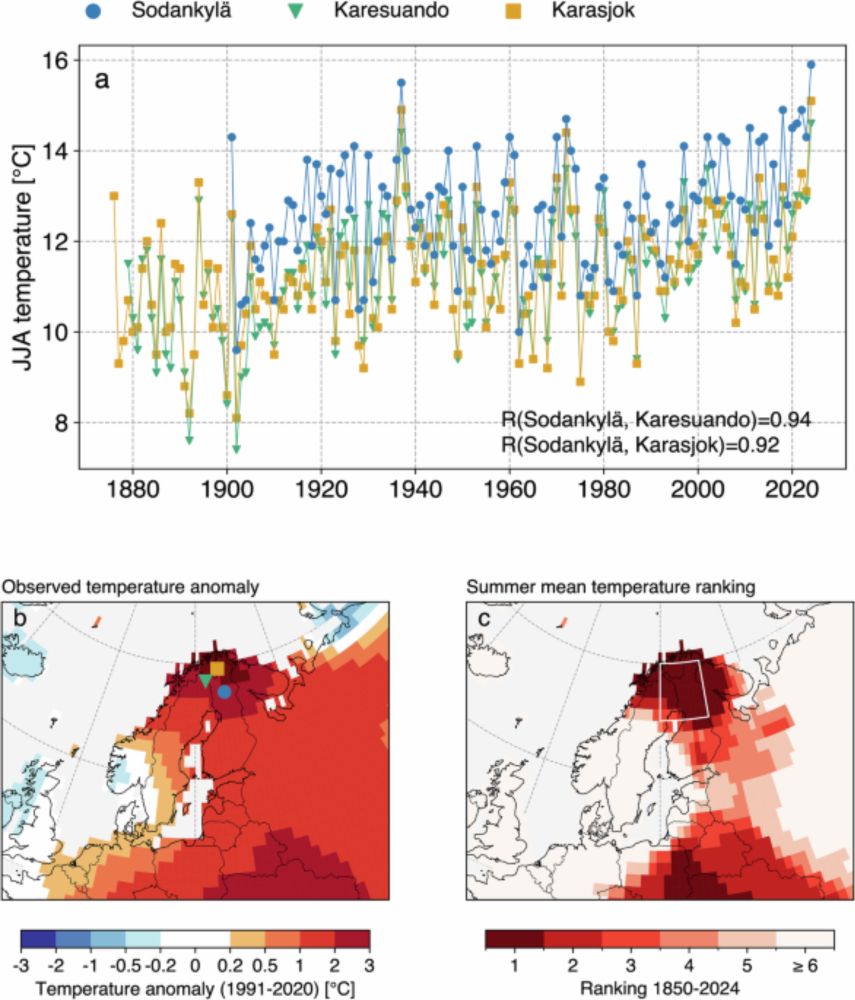
Summer 2024 in northern Fennoscandia was very likely the warmest in 2000 years - npj Climate and Atmospheric Science
npj Climate and Atmospheric Science - Summer 2024 in northern Fennoscandia was very likely the warmest in 2000 years
doi.org
Excited to share that our new paper
“Summer 2024 in northern Fennoscandia was very likely the warmest in 2000 years”
has been published in npj Climate and Atmospheric Science!
See the open-access paper from doi.org/10.1038/s416...
Short thread 👇
“Summer 2024 in northern Fennoscandia was very likely the warmest in 2000 years”
has been published in npj Climate and Atmospheric Science!
See the open-access paper from doi.org/10.1038/s416...
Short thread 👇
Came across what appears to be the 1st peer-reviewed paper against the world record temperature of 56.7 °C (134 °F) in Death Valley in 1913: journals.ametsoc.org/view/journal...
They present evidence that the reading should be in reality 7.8 °C lower, 48.9 °C (120 °F).
They present evidence that the reading should be in reality 7.8 °C lower, 48.9 °C (120 °F).
journals.ametsoc.org
November 11, 2025 at 10:20 AM
Came across what appears to be the 1st peer-reviewed paper against the world record temperature of 56.7 °C (134 °F) in Death Valley in 1913: journals.ametsoc.org/view/journal...
They present evidence that the reading should be in reality 7.8 °C lower, 48.9 °C (120 °F).
They present evidence that the reading should be in reality 7.8 °C lower, 48.9 °C (120 °F).
Elämäni ensimmäinen akatemiatutkijan hakemus Suomen Akatemialle jätetty! Ja jopa päivä ennen takarajaa.
Olihan siinä hommaa paketoida päässä oleva idea äärisäätutkimuksesta 12 sivun tutkimussuunnitelmaksi, mutta lopulta olin tyytyväinen lopputulokseen. Toivotaan että se näkyy arvioitsijoille 🤞
Olihan siinä hommaa paketoida päässä oleva idea äärisäätutkimuksesta 12 sivun tutkimussuunnitelmaksi, mutta lopulta olin tyytyväinen lopputulokseen. Toivotaan että se näkyy arvioitsijoille 🤞
November 11, 2025 at 8:32 AM
Elämäni ensimmäinen akatemiatutkijan hakemus Suomen Akatemialle jätetty! Ja jopa päivä ennen takarajaa.
Olihan siinä hommaa paketoida päässä oleva idea äärisäätutkimuksesta 12 sivun tutkimussuunnitelmaksi, mutta lopulta olin tyytyväinen lopputulokseen. Toivotaan että se näkyy arvioitsijoille 🤞
Olihan siinä hommaa paketoida päässä oleva idea äärisäätutkimuksesta 12 sivun tutkimussuunnitelmaksi, mutta lopulta olin tyytyväinen lopputulokseen. Toivotaan että se näkyy arvioitsijoille 🤞
Vierailin tänään Ari-Juhani Punkan vieraana myrskyvaroitus-videoblogissa. Juteltiin kesäkaudesta, pitkistä ennusteista ja tulevasta polaaripyörteen heikkenemisestä. Käy kuuntelemassa: youtu.be/kVnWPLge81I?...
youtu.be
November 10, 2025 at 4:40 PM
Vierailin tänään Ari-Juhani Punkan vieraana myrskyvaroitus-videoblogissa. Juteltiin kesäkaudesta, pitkistä ennusteista ja tulevasta polaaripyörteen heikkenemisestä. Käy kuuntelemassa: youtu.be/kVnWPLge81I?...
Latest ECMWF subseasonal forecast shows ensemble mean zonal wind of about 5 m/s at 10 hPa in late November, with roughly 20–30 % of ensemble members indicating a reversal to easterlies (i.e. going < 0 m/s).
This suggests a non-zero probabilty for a major SSW event!
This suggests a non-zero probabilty for a major SSW event!

November 10, 2025 at 11:52 AM
Latest ECMWF subseasonal forecast shows ensemble mean zonal wind of about 5 m/s at 10 hPa in late November, with roughly 20–30 % of ensemble members indicating a reversal to easterlies (i.e. going < 0 m/s).
This suggests a non-zero probabilty for a major SSW event!
This suggests a non-zero probabilty for a major SSW event!
The first week of November (1.-7.11.) was record-warm in Helsinki, Finland. The average temperature was 9.3 °C.
Records have been kept since 1882.
Records have been kept since 1882.

November 8, 2025 at 3:26 PM
The first week of November (1.-7.11.) was record-warm in Helsinki, Finland. The average temperature was 9.3 °C.
Records have been kept since 1882.
Records have been kept since 1882.
Reposted by Mika Rantanen

Vuodesta 2025 on tulossa maailmanlaajuisesti mittaushistorian toiseksi tai kolmanneksi lämpimin vuosi, selviää WMO:n State of the Global Climate Update 2025 -raportista. Seuraukset ovat näkyneet vuoden aikana esimerkiksi sään ääri-ilmiöinä.
www.ilmatieteenlaitos.fi/tiedote/3O5H...
www.ilmatieteenlaitos.fi/tiedote/3O5H...

Ilmaston lämpeneminen jatkuu poikkeuksellisena – vuodesta 2025 on
Vuodesta 2025 on tulossa maailmanlaajuisesti mittaushistorian toiseksi tai kolmanneksi lämpimin vuosi, selviää Maailman ilmatieteen järjestö WMO:n State of the Global Climate Update 2025 -raportista.
www.ilmatieteenlaitos.fi
November 6, 2025 at 3:03 PM
Vuodesta 2025 on tulossa maailmanlaajuisesti mittaushistorian toiseksi tai kolmanneksi lämpimin vuosi, selviää WMO:n State of the Global Climate Update 2025 -raportista. Seuraukset ovat näkyneet vuoden aikana esimerkiksi sään ääri-ilmiöinä.
www.ilmatieteenlaitos.fi/tiedote/3O5H...
www.ilmatieteenlaitos.fi/tiedote/3O5H...
Reposted by Mika Rantanen
Lämpötilamittari näytti tänään ip Tohmajärven Kemiessä 11,5, mutta Hammaslahdessa 12,5 C! Kiteen Päätyeenlahdella oli liki tuhat vesilintua, mm. 141 uiveloa ja 4 harmaasorsaa. Ei ole normaalia marraskuuta. @mikarantane.bsky.social #BirdLifeFinland #Kitee

November 5, 2025 at 6:26 PM
Lämpötilamittari näytti tänään ip Tohmajärven Kemiessä 11,5, mutta Hammaslahdessa 12,5 C! Kiteen Päätyeenlahdella oli liki tuhat vesilintua, mm. 141 uiveloa ja 4 harmaasorsaa. Ei ole normaalia marraskuuta. @mikarantane.bsky.social #BirdLifeFinland #Kitee
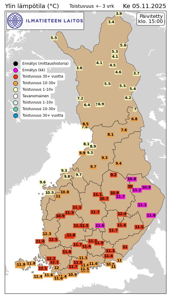
Unprecedentedly warm November day in eastern Finland, especially in North Karelia.
Multiple monthly heat records, including
Tohmajärvi Kemie 11.8 °C
Liperi Joensuu airport 11.1 °C
Juuka Niemelä 11.2 °C
Lieksa Lampela 10.9 °C
Nurmes Valtimo 10.8 °C
(shown with magenta in the map)
Multiple monthly heat records, including
Tohmajärvi Kemie 11.8 °C
Liperi Joensuu airport 11.1 °C
Juuka Niemelä 11.2 °C
Lieksa Lampela 10.9 °C
Nurmes Valtimo 10.8 °C
(shown with magenta in the map)
November 5, 2025 at 1:17 PM
Unprecedentedly warm November day in eastern Finland, especially in North Karelia.
Multiple monthly heat records, including
Tohmajärvi Kemie 11.8 °C
Liperi Joensuu airport 11.1 °C
Juuka Niemelä 11.2 °C
Lieksa Lampela 10.9 °C
Nurmes Valtimo 10.8 °C
(shown with magenta in the map)
Multiple monthly heat records, including
Tohmajärvi Kemie 11.8 °C
Liperi Joensuu airport 11.1 °C
Juuka Niemelä 11.2 °C
Lieksa Lampela 10.9 °C
Nurmes Valtimo 10.8 °C
(shown with magenta in the map)
Exceptionally mild airflow over central Finland today.
Liperi Joensuu airport just set a new November heat record with a temperature of 10.8 °C.
The reading is provisional and may still rise during the day.
Liperi Joensuu airport just set a new November heat record with a temperature of 10.8 °C.
The reading is provisional and may still rise during the day.


November 5, 2025 at 8:13 AM
Exceptionally mild airflow over central Finland today.
Liperi Joensuu airport just set a new November heat record with a temperature of 10.8 °C.
The reading is provisional and may still rise during the day.
Liperi Joensuu airport just set a new November heat record with a temperature of 10.8 °C.
The reading is provisional and may still rise during the day.
Reposted by Mika Rantanen
Incredible Arctic heat in October. Highest average temperature on record for land and seas north of 60ºN. In Canada, Yukon Territory and Nunavut second warmest, Northwest Territories third warmest. Alaska and Svalbard fourth warmest. Data courtesy ERA5. #akwx #Arctic #Canada #Climate

November 5, 2025 at 4:28 AM
Interesting new paper states that forced changes in variability may lead to more extreme heatwaves in northern Europe this century.
So far, heatwaves in W-Europe have become disproportionately more intense compared to other Europe but this seems to change.
www.nature.com/articles/s41...
So far, heatwaves in W-Europe have become disproportionately more intense compared to other Europe but this seems to change.
www.nature.com/articles/s41...

Increasing central and northern European summer heatwave intensity due to forced changes in internal variability - Nature Communications
Projected changes in internal climate variability are expected to amplify heatwave intensity in central and northern Europe—making these events more severe and less predictable—while dampening the tre...
www.nature.com
November 3, 2025 at 10:04 AM
Interesting new paper states that forced changes in variability may lead to more extreme heatwaves in northern Europe this century.
So far, heatwaves in W-Europe have become disproportionately more intense compared to other Europe but this seems to change.
www.nature.com/articles/s41...
So far, heatwaves in W-Europe have become disproportionately more intense compared to other Europe but this seems to change.
www.nature.com/articles/s41...
Reposted by Mika Rantanen

☀️🌧️ Extreme weather events are increasing 🌀🌤
Our new paper discusses the range of extreme weather attribution methods available and how we should be combining them to improve confidence in our attribution statements
with co-authors: @marylouathanase.bsky.social & Shirin Ermis
doi.org/10.1002/wea....
Our new paper discusses the range of extreme weather attribution methods available and how we should be combining them to improve confidence in our attribution statements
with co-authors: @marylouathanase.bsky.social & Shirin Ermis
doi.org/10.1002/wea....

The need for multi‐method extreme event attribution
Over the past 20 years, extreme event attribution has developed rapidly, providing a wide range of methods to attribute weather events – from unconditioned probabilistic to strongly conditioned story...
rmets.onlinelibrary.wiley.com
November 3, 2025 at 9:32 AM
☀️🌧️ Extreme weather events are increasing 🌀🌤
Our new paper discusses the range of extreme weather attribution methods available and how we should be combining them to improve confidence in our attribution statements
with co-authors: @marylouathanase.bsky.social & Shirin Ermis
doi.org/10.1002/wea....
Our new paper discusses the range of extreme weather attribution methods available and how we should be combining them to improve confidence in our attribution statements
with co-authors: @marylouathanase.bsky.social & Shirin Ermis
doi.org/10.1002/wea....
Year-to-date temperatures in Sodankylä Tähtelä (northern Fennoscandia) are currently tracking record-high and exceeding the long-standing 1938 record.
The best chance so far to beat the 1938 annual temperature record but it would still require anomalously warm end to the year.
The best chance so far to beat the 1938 annual temperature record but it would still require anomalously warm end to the year.

November 3, 2025 at 9:05 AM
Year-to-date temperatures in Sodankylä Tähtelä (northern Fennoscandia) are currently tracking record-high and exceeding the long-standing 1938 record.
The best chance so far to beat the 1938 annual temperature record but it would still require anomalously warm end to the year.
The best chance so far to beat the 1938 annual temperature record but it would still require anomalously warm end to the year.
Reposted by Mika Rantanen

So, I hate to be this guy, but as the director of Yale’s new program on attribution science (!?), uh, most of the commentary on Bluesky about Hurricane Melissa and climate change has been… not quite right
October 31, 2025 at 2:19 AM
So, I hate to be this guy, but as the director of Yale’s new program on attribution science (!?), uh, most of the commentary on Bluesky about Hurricane Melissa and climate change has been… not quite right
Reposted by Mika Rantanen

Multi-panel view of the last few days of Hurricane Melissa:
↖️ GOES-19 infrared brightness temp
↗️ GOES-19 visible satellite
↙️ Hurricane hunter planes & flight paths
↘️ Recon-derived flight level wind swath
⬇️ Estimated minimum pressure from recon dropsondes
↖️ GOES-19 infrared brightness temp
↗️ GOES-19 visible satellite
↙️ Hurricane hunter planes & flight paths
↘️ Recon-derived flight level wind swath
⬇️ Estimated minimum pressure from recon dropsondes
October 29, 2025 at 10:14 PM
Multi-panel view of the last few days of Hurricane Melissa:
↖️ GOES-19 infrared brightness temp
↗️ GOES-19 visible satellite
↙️ Hurricane hunter planes & flight paths
↘️ Recon-derived flight level wind swath
⬇️ Estimated minimum pressure from recon dropsondes
↖️ GOES-19 infrared brightness temp
↗️ GOES-19 visible satellite
↙️ Hurricane hunter planes & flight paths
↘️ Recon-derived flight level wind swath
⬇️ Estimated minimum pressure from recon dropsondes
"Aiemmissa tutkimuksissa on havaittu, että ilmastonmuutos lisää hurrikaanien tuulien voimakkuutta noin 5–10 metriä sekunnissa. Ilmastonmuutoksesta johtuva merivesien lämpeneminen teki Melissasta siis entistä tuhoisamman"
www.ilmatieteenlaitos.fi/tiedote/3lWQ...
www.ilmatieteenlaitos.fi/tiedote/3lWQ...

Hirmumyrsky Melissa iski tuhoisasti Jamaikalle – jatkaa kulkuaan
Melissan tuulet puhalsivat kovimmillaan 83 metriä sekunnissa, ja se on voimakkain koskaan Jamaikalle rantautunut hurrikaani. Ilmastonmuutos voimistaa hirmumyrskyjä.
www.ilmatieteenlaitos.fi
October 29, 2025 at 1:48 PM
"Aiemmissa tutkimuksissa on havaittu, että ilmastonmuutos lisää hurrikaanien tuulien voimakkuutta noin 5–10 metriä sekunnissa. Ilmastonmuutoksesta johtuva merivesien lämpeneminen teki Melissasta siis entistä tuhoisamman"
www.ilmatieteenlaitos.fi/tiedote/3lWQ...
www.ilmatieteenlaitos.fi/tiedote/3lWQ...
Reposted by Mika Rantanen

Hurricanes feed off of warm water. Watch how quickly the eye of #Melissa collapsed as it moved onto land and over the mountainous terrain of Jamaica, and how quickly it is reforming now that it has moved back over water! I will be adding this radar loop to my earth science lectures.
October 29, 2025 at 1:20 AM
Hurricanes feed off of warm water. Watch how quickly the eye of #Melissa collapsed as it moved onto land and over the mountainous terrain of Jamaica, and how quickly it is reforming now that it has moved back over water! I will be adding this radar loop to my earth science lectures.
Reposted by Mika Rantanen

Reposted by Mika Rantanen

We have official LANDFALL near New Hope, Jamaica
#Melissa officially ties the 1935 Labor Day Hurricane as the most intense Atlantic hurricane landfall on record
Min pressure 892mb
Max sustained winds 185mph
#Melissa officially ties the 1935 Labor Day Hurricane as the most intense Atlantic hurricane landfall on record
Min pressure 892mb
Max sustained winds 185mph
October 28, 2025 at 5:07 PM
We have official LANDFALL near New Hope, Jamaica
#Melissa officially ties the 1935 Labor Day Hurricane as the most intense Atlantic hurricane landfall on record
Min pressure 892mb
Max sustained winds 185mph
#Melissa officially ties the 1935 Labor Day Hurricane as the most intense Atlantic hurricane landfall on record
Min pressure 892mb
Max sustained winds 185mph
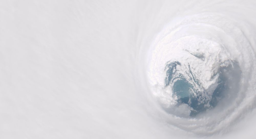
It's hard to get a more symmetric and well-defined hurricane structure than the latest satellite images of Melissa.
One of the most intense storms the Atlantic has ever seen and unfortunately, just at the landfall.
One of the most intense storms the Atlantic has ever seen and unfortunately, just at the landfall.

October 28, 2025 at 2:35 PM
It's hard to get a more symmetric and well-defined hurricane structure than the latest satellite images of Melissa.
One of the most intense storms the Atlantic has ever seen and unfortunately, just at the landfall.
One of the most intense storms the Atlantic has ever seen and unfortunately, just at the landfall.
Reposted by Mika Rantanen

Simply incredible imagery of Hurricane Melissa this morning as it approaches Jamaica.
October 28, 2025 at 1:41 PM
Simply incredible imagery of Hurricane Melissa this morning as it approaches Jamaica.
Reposted by Mika Rantanen

#Melissa unfortunately is still intensifying. A 9am EDT Tropical Cyclone Update indicates that winds are up to 180 mph, with an estimated minimum pressure of 896 mb.
You can see how GLM lightning has 📈 in the past hour, encircling the eye, with eye WV temp still increasing!
You can see how GLM lightning has 📈 in the past hour, encircling the eye, with eye WV temp still increasing!
October 28, 2025 at 1:13 PM
#Melissa unfortunately is still intensifying. A 9am EDT Tropical Cyclone Update indicates that winds are up to 180 mph, with an estimated minimum pressure of 896 mb.
You can see how GLM lightning has 📈 in the past hour, encircling the eye, with eye WV temp still increasing!
You can see how GLM lightning has 📈 in the past hour, encircling the eye, with eye WV temp still increasing!
Oikeastaan pahin mahdollinen skenaario näyttäisi toteutuvan. Hurrikaani Melissa on jatkanut voimistumistaan juuri ennen rantautumistaan Jamakaille. Maksimikeskituulet puhaltavat nyt 80 m/s, ja pintapaine on laskenut 896 hPa:iin.
Yksi kaikkien aikojen voimakkaimmista myrskyistä Atlantilla.
Yksi kaikkien aikojen voimakkaimmista myrskyistä Atlantilla.

October 28, 2025 at 1:18 PM
Oikeastaan pahin mahdollinen skenaario näyttäisi toteutuvan. Hurrikaani Melissa on jatkanut voimistumistaan juuri ennen rantautumistaan Jamakaille. Maksimikeskituulet puhaltavat nyt 80 m/s, ja pintapaine on laskenut 896 hPa:iin.
Yksi kaikkien aikojen voimakkaimmista myrskyistä Atlantilla.
Yksi kaikkien aikojen voimakkaimmista myrskyistä Atlantilla.
Reposted by Mika Rantanen

Those physically realistic models predict subpolar gyre tipping around 2040-2050. This would lead to a local cooling of 1-2 degrees in 10 to 20 years. The Nordic seas would warm, the jet stream shift northward and in summer high pressure over Scandinavia could lead to more (intense) heat waves.

October 28, 2025 at 12:27 PM
Those physically realistic models predict subpolar gyre tipping around 2040-2050. This would lead to a local cooling of 1-2 degrees in 10 to 20 years. The Nordic seas would warm, the jet stream shift northward and in summer high pressure over Scandinavia could lead to more (intense) heat waves.
Lue alta uutinen uudesta hankkeestamme jossa saan olla mukana tutkimassa äärimmäisiä mutta mahdollisia helleaaltoja Uudenmaan alueella. ☀️
👇
👇
Käynnistimme kuuden Uudenmaan kunnan kanssa tutkimusyhteistyön, jossa tuotetaan tarkkaa alueellista tietoa ilmastonmuutoksesta ja arvioidaan sopeutumistoimien vaikutuksia. Tieto auttaa kuntia sopeutumaan ilmastonmuutokseen.
www.ilmatieteenlaitos.fi/uutinen/2MBl...
www.ilmatieteenlaitos.fi/uutinen/2MBl...

Tutkimusyhteistyö auttaa Uudenmaan kuntia sopeutumaan
Ilmatieteen laitos ja kuusi Uudenmaan kuntaa käynnistivät tutkimusyhteistyön, jossa tuotetaan tarkkaa alueellista ilmastonmuutostietoa ja arvioidaan sopeutumistoimien vaikutuksia.
www.ilmatieteenlaitos.fi
October 28, 2025 at 8:20 AM
Lue alta uutinen uudesta hankkeestamme jossa saan olla mukana tutkimassa äärimmäisiä mutta mahdollisia helleaaltoja Uudenmaan alueella. ☀️
👇
👇