

john10hoeve.bsky.social
@john10hoeve.bsky.social
Reposted by john10hoeve.bsky.social

3 GOOD: some real approps working right for the first time in EONS, built based on need & politics, not from toplines. SHALL language on backpay 4 feds. Good anti-RIF language we’d want to see continued
2 BAD: Nothing forces Trump to actually FOLLOW the approps. A vote we could have forced already
2 BAD: Nothing forces Trump to actually FOLLOW the approps. A vote we could have forced already
Text of the CR here. Negative implications galore.
www.appropriations.senate.gov/imo/media/do...
www.appropriations.senate.gov/imo/media/do...
www.appropriations.senate.gov
November 10, 2025 at 12:10 AM
3 GOOD: some real approps working right for the first time in EONS, built based on need & politics, not from toplines. SHALL language on backpay 4 feds. Good anti-RIF language we’d want to see continued
2 BAD: Nothing forces Trump to actually FOLLOW the approps. A vote we could have forced already
2 BAD: Nothing forces Trump to actually FOLLOW the approps. A vote we could have forced already
Ok I’ll be the 133244th person to say this game is insane, because it is
November 2, 2025 at 3:43 AM
Ok I’ll be the 133244th person to say this game is insane, because it is
Setting up for Ohtani to be the final out…
November 2, 2025 at 2:56 AM
Setting up for Ohtani to be the final out…
Reposted by john10hoeve.bsky.social

NHC: 180 mph and 896 mb!
October 28, 2025 at 1:03 PM
NHC: 180 mph and 896 mb!
Reposted by john10hoeve.bsky.social

From a crewmember on yesterday's Teal 74 mission into now-Category 5 Hurricane #Melissa. As clear of an eye as you will see in the Atlantic basin.
October 27, 2025 at 4:11 PM
From a crewmember on yesterday's Teal 74 mission into now-Category 5 Hurricane #Melissa. As clear of an eye as you will see in the Atlantic basin.
Reposted by john10hoeve.bsky.social

From sunrise to sunset, Hurricane Melissa is still a Category 5 storm as it starts to move northward towards Jamaica.
October 27, 2025 at 11:24 PM
From sunrise to sunset, Hurricane Melissa is still a Category 5 storm as it starts to move northward towards Jamaica.
Why does McCaffrey have to be so good, and where did this SF defense come from?
October 20, 2025 at 3:05 AM
Why does McCaffrey have to be so good, and where did this SF defense come from?
Reposted by john10hoeve.bsky.social

Prof Kirstine Dale spoke to Tech Monitor about the valuable opportunities AI and ML create across our operations, with the irreplaceable expertise of our data scientists for weather and climate intelligence.
Read the full article ⤵️
www.techmonitor.ai/movers-and-s...
Read the full article ⤵️
www.techmonitor.ai/movers-and-s...

October 15, 2025 at 9:57 AM
Prof Kirstine Dale spoke to Tech Monitor about the valuable opportunities AI and ML create across our operations, with the irreplaceable expertise of our data scientists for weather and climate intelligence.
Read the full article ⤵️
www.techmonitor.ai/movers-and-s...
Read the full article ⤵️
www.techmonitor.ai/movers-and-s...
Reposted by john10hoeve.bsky.social

Grid scale batteries are changing our electricity system. Excellent new visual story on batteries in FT today shows just how far this technology has evolved.
Fasten your seatbelts, this is just the beginning.
ig.ft.com/mega-batteri...
Fasten your seatbelts, this is just the beginning.
ig.ft.com/mega-batteri...

October 13, 2025 at 10:26 AM
Grid scale batteries are changing our electricity system. Excellent new visual story on batteries in FT today shows just how far this technology has evolved.
Fasten your seatbelts, this is just the beginning.
ig.ft.com/mega-batteri...
Fasten your seatbelts, this is just the beginning.
ig.ft.com/mega-batteri...
Congress is losing its grip on the power to spend Americans’ money
October 13, 2025 at 10:02 PM
Congress is losing its grip on the power to spend Americans’ money
Wtf is the PSU coaching staff doing?
October 4, 2025 at 8:58 PM
Wtf is the PSU coaching staff doing?
Reposted by john10hoeve.bsky.social

Cropland area nearly doubled in South America between 2000 and 2019 - the largest relative increase in the world. Soybean production replaced rainforests, grasslands & savannas. earthobservatory.nasa.gov/images/14962... As China refuses U.S. soybeans, this puts more pressure on natural ecosystems.

The Spread of Soy in South America
Grasslands, savannas, and dry forests have become popular places to grow soy.
earthobservatory.nasa.gov
September 29, 2025 at 3:07 PM
Cropland area nearly doubled in South America between 2000 and 2019 - the largest relative increase in the world. Soybean production replaced rainforests, grasslands & savannas. earthobservatory.nasa.gov/images/14962... As China refuses U.S. soybeans, this puts more pressure on natural ecosystems.
Deterministic GFS seems to be trending ahead of Euro for Humberto and tropical depression 9. Interested to see what happens with this complex forecast
September 28, 2025 at 2:52 PM
Deterministic GFS seems to be trending ahead of Euro for Humberto and tropical depression 9. Interested to see what happens with this complex forecast
Reposted by john10hoeve.bsky.social

I’m proud to say that @noaa.gov and NCEI has released a 1 year retrospective on #Helene using ESRI Story Maps.
arcg.is/aqCD4
Here is a brief thread of how this came to be and how NOAA can still do good things (even while wearing pajamas).
arcg.is/aqCD4
Here is a brief thread of how this came to be and how NOAA can still do good things (even while wearing pajamas).

Helene in Southern Appalachia
One year later: An event analysis and how we move forward.
arcg.is
September 16, 2025 at 4:25 PM
I’m proud to say that @noaa.gov and NCEI has released a 1 year retrospective on #Helene using ESRI Story Maps.
arcg.is/aqCD4
Here is a brief thread of how this came to be and how NOAA can still do good things (even while wearing pajamas).
arcg.is/aqCD4
Here is a brief thread of how this came to be and how NOAA can still do good things (even while wearing pajamas).
Reposted by john10hoeve.bsky.social

🌍 The MMM lab at @ncar-ucar.bsky.social is running experimental realtime forecasts with a global 3.75-km MPAS model.
Goal: Highlight the power of global km-scale models for weather prediction from local to planetary scales, incl. tropical cyclones.
👉 project.mmm.ucar.edu/real-time-fo...
Goal: Highlight the power of global km-scale models for weather prediction from local to planetary scales, incl. tropical cyclones.
👉 project.mmm.ucar.edu/real-time-fo...

September 5, 2025 at 3:30 PM
🌍 The MMM lab at @ncar-ucar.bsky.social is running experimental realtime forecasts with a global 3.75-km MPAS model.
Goal: Highlight the power of global km-scale models for weather prediction from local to planetary scales, incl. tropical cyclones.
👉 project.mmm.ucar.edu/real-time-fo...
Goal: Highlight the power of global km-scale models for weather prediction from local to planetary scales, incl. tropical cyclones.
👉 project.mmm.ucar.edu/real-time-fo...
Reposted by john10hoeve.bsky.social

Numerical weather prediction models (ECMWF IFS) still outperform AI weather models in forecasting record-breaking hot and cold extremes and unseen wind extremes
Preprint
arxiv.org/abs/2508.15724
with Zhongwei Zhang @erichfischer.bsky.social @zscheischlerjak.bsky.social and Sebastian Engelke
Preprint
arxiv.org/abs/2508.15724
with Zhongwei Zhang @erichfischer.bsky.social @zscheischlerjak.bsky.social and Sebastian Engelke

Numerical models outperform AI weather forecasts of record-breaking extremes
Artificial intelligence (AI)-based models are revolutionizing weather forecasting and have surpassed leading numerical weather prediction systems on various benchmark tasks. However, their ability to ...
arxiv.org
August 22, 2025 at 5:43 AM
Numerical weather prediction models (ECMWF IFS) still outperform AI weather models in forecasting record-breaking hot and cold extremes and unseen wind extremes
Preprint
arxiv.org/abs/2508.15724
with Zhongwei Zhang @erichfischer.bsky.social @zscheischlerjak.bsky.social and Sebastian Engelke
Preprint
arxiv.org/abs/2508.15724
with Zhongwei Zhang @erichfischer.bsky.social @zscheischlerjak.bsky.social and Sebastian Engelke
Reposted by john10hoeve.bsky.social

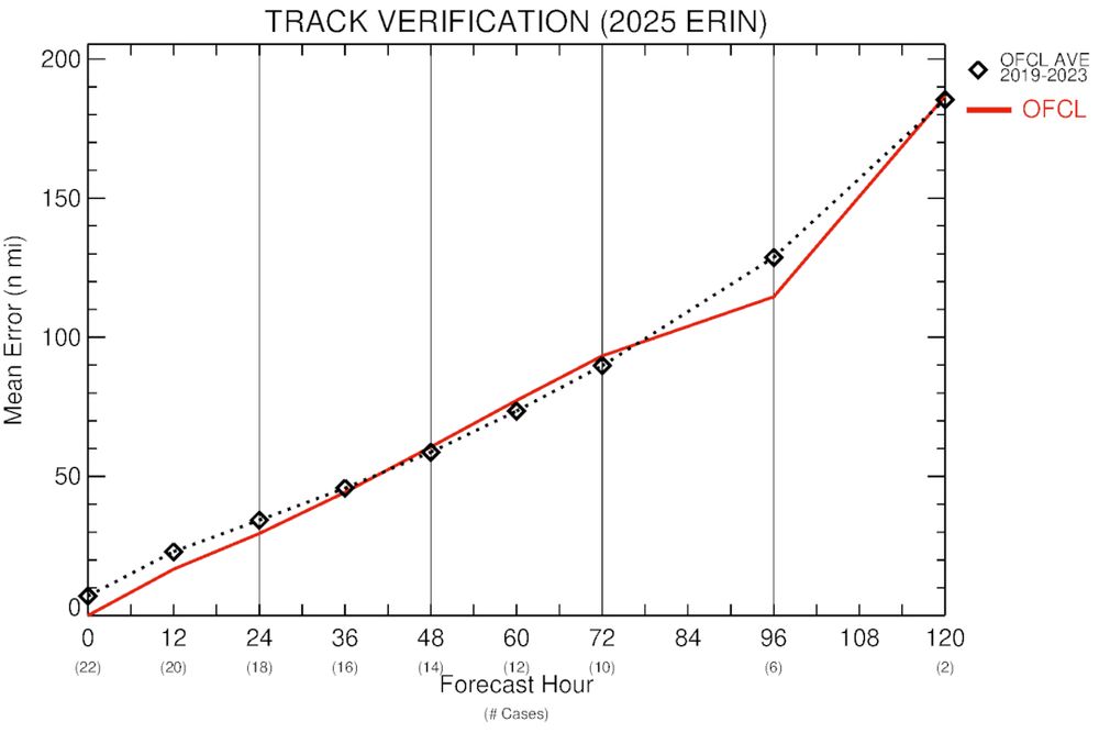
How fast was Hurricane Erin's intensification rate vs. past Atlantic storms?
It wasn't record shattering - but still in the uppermost ranks of Atlantic hurricanes, especially over a 6-hour period:
It wasn't record shattering - but still in the uppermost ranks of Atlantic hurricanes, especially over a 6-hour period:

August 16, 2025 at 9:19 PM
How fast was Hurricane Erin's intensification rate vs. past Atlantic storms?
It wasn't record shattering - but still in the uppermost ranks of Atlantic hurricanes, especially over a 6-hour period:
It wasn't record shattering - but still in the uppermost ranks of Atlantic hurricanes, especially over a 6-hour period:
Reposted by john10hoeve.bsky.social

While the NHC's track forecast errors for #Erin have been right around average, the intensity errors are just brutal. Erin was slow to develop when it was forecast to develop, and then explosively intensified when it was forecast to "only" rapidly intensify.


August 16, 2025 at 9:29 PM
While the NHC's track forecast errors for #Erin have been right around average, the intensity errors are just brutal. Erin was slow to develop when it was forecast to develop, and then explosively intensified when it was forecast to "only" rapidly intensify.
Reposted by john10hoeve.bsky.social

Reposted by john10hoeve.bsky.social

The flood watch ahead of yesterday's deluge was DC's 16th so far this year.
‼️DC has had more flood watches than any other major city!!!
‼️DC has had more flood watches than any other major city!!!

July 20, 2025 at 12:42 PM
The flood watch ahead of yesterday's deluge was DC's 16th so far this year.
‼️DC has had more flood watches than any other major city!!!
‼️DC has had more flood watches than any other major city!!!
Reposted by john10hoeve.bsky.social
553p: This flash flood warning is not because of rain in DC but because of massive amount of water heading thru Rock Creek from upstream (coming from Montgomery County where rain is torrential). Stay away from Rock Creek Park. #cwgalert

July 19, 2025 at 9:54 PM
553p: This flash flood warning is not because of rain in DC but because of massive amount of water heading thru Rock Creek from upstream (coming from Montgomery County where rain is torrential). Stay away from Rock Creek Park. #cwgalert

Reposted by john10hoeve.bsky.social

"Strongest Nor’easters Getting Stronger" | Great piece on our new study by Michele Berger for @upenn.edu #OmniaMagazine: omnia.sas.upenn.edu/story/strong...
Strongest Nor easters Getting Stronger
Research from Professor Michael Mann and PhD students Annabelle Horton and Mackenzie Weaver shows that as the worst of these East Coast winter storms intensify, so does their destructive potential—a f...
omnia.sas.upenn.edu
July 14, 2025 at 7:37 PM
"Strongest Nor’easters Getting Stronger" | Great piece on our new study by Michele Berger for @upenn.edu #OmniaMagazine: omnia.sas.upenn.edu/story/strong...
Reposted by john10hoeve.bsky.social

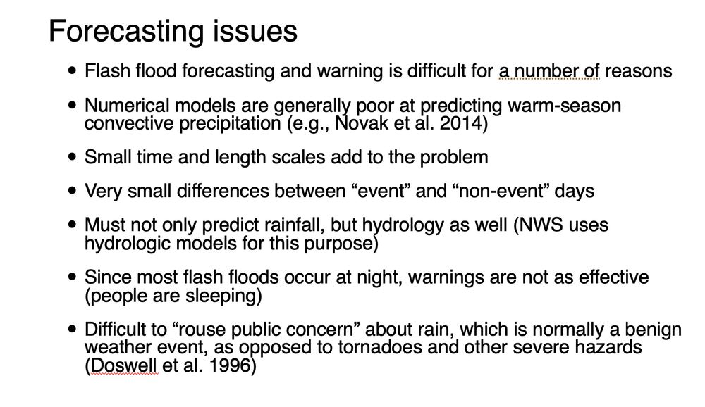
Exactly. This is a slide from my mesoscale class on flash flooding (mainly just taken from Doswell et al. 1996)...this event hit every one of these bullets...
July 6, 2025 at 2:50 AM
Exactly. This is a slide from my mesoscale class on flash flooding (mainly just taken from Doswell et al. 1996)...this event hit every one of these bullets...