🇺🇸/🇩🇪
Clouds cresting over the Front Range and cascading downward. The "dust front" with the strongest winds kept sweeping eastward from the base of the foothills.
A peak wind gust of 71 mph was recorded at my location during the event.

Clouds cresting over the Front Range and cascading downward. The "dust front" with the strongest winds kept sweeping eastward from the base of the foothills.
A peak wind gust of 71 mph was recorded at my location during the event.
UCAR President Antonio Busalacchi hosts this town hall on what’s at stake if NSF NCAR is dismantled.
buff.ly/jR6tGwo

UCAR President Antonio Busalacchi hosts this town hall on what’s at stake if NSF NCAR is dismantled.
buff.ly/jR6tGwo
Some thoughts I put together today on the administration's NCAR destruction announced today:

Some thoughts I put together today on the administration's NCAR destruction announced today:
news.ucar.edu/133040/scien...
news.ucar.edu/133040/scien...
By better resolving Taiwan’s terrain and upslope rainfall, the high-res run shows the value of higher resolution in complex terrain.


By better resolving Taiwan’s terrain and upslope rainfall, the high-res run shows the value of higher resolution in complex terrain.
By better resolving Taiwan’s terrain and upslope rainfall, the high-res run shows the value of higher resolution in complex terrain.


By better resolving Taiwan’s terrain and upslope rainfall, the high-res run shows the value of higher resolution in complex terrain.
👉 project.mmm.ucar.edu/real-time-fo...
👉 project.mmm.ucar.edu/real-time-fo...
👉 project.mmm.ucar.edu/real-time-fo... Variable: Infrared Brightness Temp, Domain: Invest 90 (WP90)

👉 project.mmm.ucar.edu/real-time-fo... Variable: Infrared Brightness Temp, Domain: Invest 90 (WP90)
- a squall line over western Africa
- a tropical storm near 30°W
- another less well defined tropical system near 45°W
👉 project.mmm.ucar.edu/real-time-fo...

- a squall line over western Africa
- a tropical storm near 30°W
- another less well defined tropical system near 45°W
👉 project.mmm.ucar.edu/real-time-fo...


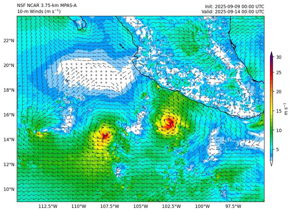
👉 project.mmm.ucar.edu/real-time-fo...
variable: 10-m Winds, domain: EPAC (zoom), forecast hour 120

👉 project.mmm.ucar.edu/real-time-fo...
variable: 10-m Winds, domain: EPAC (zoom), forecast hour 120

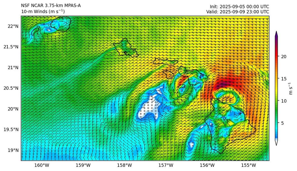
👉 project.mmm.ucar.edu/real-time-fo...
Variable: 10-m Winds, Domain: Hawaii

👉 project.mmm.ucar.edu/real-time-fo...
Variable: 10-m Winds, Domain: Hawaii
Goal: Highlight the power of global km-scale models for weather prediction from local to planetary scales, incl. tropical cyclones.
👉 project.mmm.ucar.edu/real-time-fo...

Goal: Highlight the power of global km-scale models for weather prediction from local to planetary scales, incl. tropical cyclones.
👉 project.mmm.ucar.edu/real-time-fo...


Big question is: are these “trains” predictable on S2S time scales (weeks in advance)?
Can't say I recall ever seeing this before.
Big question is: are these “trains” predictable on S2S time scales (weeks in advance)?
(1) Golden, CO and its table mountains
(2) Berthoud Pass
(3) Rocky🏔️ after the first ❄️, barren South Park in the background (Copper ⛷️ peaks out, too)
(4) Fog moving into dry hills near San Francisco


(1) Golden, CO and its table mountains
(2) Berthoud Pass
(3) Rocky🏔️ after the first ❄️, barren South Park in the background (Copper ⛷️ peaks out, too)
(4) Fog moving into dry hills near San Francisco


