@chebucto.bsky.social
Introduce yourself with four spaceships.


November 25, 2025 at 1:51 AM
Introduce yourself with four spaceships.
Well that's disappointing
November 2, 2025 at 4:18 AM
Well that's disappointing

Reposted

27 Jahre GDAL! HAPPY BIRTHDAY! / 27 years of GDAL! HAPPY BIRTHDAY! geoobserver.de/2025/10/17/2... @GdalOrg @EvenRouault #gdal #ogr #qgis #switch2qgis #fossgis #foss4g #opensource #gistribe #gischat #spatial #geospatial #gis #geo #geoObserver pls RT

October 17, 2025 at 12:50 PM
27 Jahre GDAL! HAPPY BIRTHDAY! / 27 years of GDAL! HAPPY BIRTHDAY! geoobserver.de/2025/10/17/2... @GdalOrg @EvenRouault #gdal #ogr #qgis #switch2qgis #fossgis #foss4g #opensource #gistribe #gischat #spatial #geospatial #gis #geo #geoObserver pls RT
Reposted


Further proof that radar remains the coolest remote sensing technology.
Note the quote from the article: "The measurements included a wave height exceeding 1.5 feet (45 centimeters), shown in red in the highlighted track"
45cm max heightdiff on an image 15 degrees long taken from space. Amazing.
Note the quote from the article: "The measurements included a wave height exceeding 1.5 feet (45 centimeters), shown in red in the highlighted track"
45cm max heightdiff on an image 15 degrees long taken from space. Amazing.

This is incredibly cool: NASA/CNES's SWOT satellite captured a live view of the leading edge of the tsunami formed by the 8.8 magnitude Kamchatka Peninsula earthquake!
www.nasa.gov/missions/swo...
www.nasa.gov/missions/swo...
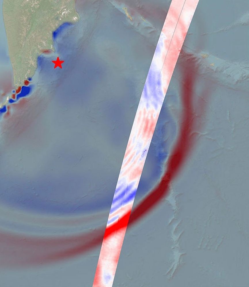
US-French SWOT Satellite Measures Tsunami After Massive Quake - NASA
Data provided by the water satellite, a joint effort between NASA and the French space agency, is helping to improve tsunami forecast models, benefitting
www.nasa.gov
August 9, 2025 at 12:43 AM
Further proof that radar remains the coolest remote sensing technology.
Note the quote from the article: "The measurements included a wave height exceeding 1.5 feet (45 centimeters), shown in red in the highlighted track"
45cm max heightdiff on an image 15 degrees long taken from space. Amazing.
Note the quote from the article: "The measurements included a wave height exceeding 1.5 feet (45 centimeters), shown in red in the highlighted track"
45cm max heightdiff on an image 15 degrees long taken from space. Amazing.
Lies last as long as the liar, the truth lasts forever
August 2, 2025 at 1:31 AM
Lies last as long as the liar, the truth lasts forever
Just realized that the NGS Webinar series hasn't been broadcast since April. Usually it's done once per month.
It doesn't seem like it'd cost very much to produce, and public outreach is actually useful, despite not bringing in any quick bucks. #geodesy
geodesy.noaa.gov/web/science_...
It doesn't seem like it'd cost very much to produce, and public outreach is actually useful, despite not bringing in any quick bucks. #geodesy
geodesy.noaa.gov/web/science_...
geodesy.noaa.gov
July 30, 2025 at 3:33 AM
Just realized that the NGS Webinar series hasn't been broadcast since April. Usually it's done once per month.
It doesn't seem like it'd cost very much to produce, and public outreach is actually useful, despite not bringing in any quick bucks. #geodesy
geodesy.noaa.gov/web/science_...
It doesn't seem like it'd cost very much to produce, and public outreach is actually useful, despite not bringing in any quick bucks. #geodesy
geodesy.noaa.gov/web/science_...
I'm getting flaky performance today from geodesy.noaa.gov . Will load once, then time out the next time I try.
Also, it looks like cddis.nasa.gov is behind an earthdata login now?!
Probably just me but seems like lots of breakage in GNSS data sources at *.gov ...
Also, it looks like cddis.nasa.gov is behind an earthdata login now?!
Probably just me but seems like lots of breakage in GNSS data sources at *.gov ...
geodesy.noaa.gov
July 1, 2025 at 3:11 AM
I'm getting flaky performance today from geodesy.noaa.gov . Will load once, then time out the next time I try.
Also, it looks like cddis.nasa.gov is behind an earthdata login now?!
Probably just me but seems like lots of breakage in GNSS data sources at *.gov ...
Also, it looks like cddis.nasa.gov is behind an earthdata login now?!
Probably just me but seems like lots of breakage in GNSS data sources at *.gov ...
Reposted

I'm looking for any info about how & why it was decided to use the Space Shuttle do create SRTM in 2000
A few questions I have:
- How of the world had we mapped in 3D before 2000?
- Why the Space Shuttle over a dedicate satellite (or pair of satellites)
- How the data was processed
A few questions I have:
- How of the world had we mapped in 3D before 2000?
- Why the Space Shuttle over a dedicate satellite (or pair of satellites)
- How the data was processed

May 25, 2025 at 2:15 PM
I'm looking for any info about how & why it was decided to use the Space Shuttle do create SRTM in 2000
A few questions I have:
- How of the world had we mapped in 3D before 2000?
- Why the Space Shuttle over a dedicate satellite (or pair of satellites)
- How the data was processed
A few questions I have:
- How of the world had we mapped in 3D before 2000?
- Why the Space Shuttle over a dedicate satellite (or pair of satellites)
- How the data was processed
Impressive and worth reading if you’re a user.
I didn’t know this before: “Development of QGIS began in 2002 as a simple viewer for the open-source spatial database PostGIS”.
Qgis: a postgis viewer that does a bunch of other stuff
I didn’t know this before: “Development of QGIS began in 2002 as a simple viewer for the open-source spatial database PostGIS”.
Qgis: a postgis viewer that does a bunch of other stuff

We've done it 🥳
Finally, there's a canonical paper on the #qgis project, its history, workings, and challenges: https://www.sciencedirect.com/science/article/pii/S2666389925001138
Thanks to @timlinux and @mbernasocchi for joining me in trying to tell the QGIS story 💚
#osgeo #gischat #giscience
Finally, there's a canonical paper on the #qgis project, its history, workings, and challenges: https://www.sciencedirect.com/science/article/pii/S2666389925001138
Thanks to @timlinux and @mbernasocchi for joining me in trying to tell the QGIS story 💚
#osgeo #gischat #giscience
May 22, 2025 at 2:47 PM
Impressive and worth reading if you’re a user.
I didn’t know this before: “Development of QGIS began in 2002 as a simple viewer for the open-source spatial database PostGIS”.
Qgis: a postgis viewer that does a bunch of other stuff
I didn’t know this before: “Development of QGIS began in 2002 as a simple viewer for the open-source spatial database PostGIS”.
Qgis: a postgis viewer that does a bunch of other stuff
NGS are the world standard for a lot of what they do. The long term planning, the research translated into continent-scale products, the tooling/data made available for current geodesy, the public outreach.. nothing like that will come from the private sector and all of it is of huge value.

SCOOP from me: the mass exodus of employees from NOAA is decimating a tiny office that literally keeps our measurements of latitude and longitude accurate — and, former employees tell me, endangers the science of how the US understands global measurements:
Trump Cuts Are Killing a Tiny Office That Keeps Measurements of the World Accurate
A tiny but crucial agency that maintains physical coordinates like latitude and longitude in the US is struggling as the Trump administration forces out federal employees.
www.wired.com
May 22, 2025 at 12:51 AM
NGS are the world standard for a lot of what they do. The long term planning, the research translated into continent-scale products, the tooling/data made available for current geodesy, the public outreach.. nothing like that will come from the private sector and all of it is of huge value.
This was floated back in the Trump I. It was a bad idea then and it's a bad idea now.
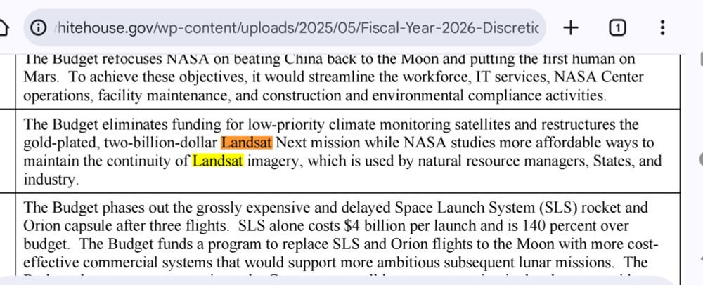
Landsat provides far more value when it is available free of charge, simply because the usage of the products is much higher. Usage benefits citizens via better modelling and monitoring of natural resources.
Landsat provides far more value when it is available free of charge, simply because the usage of the products is much higher. Usage benefits citizens via better modelling and monitoring of natural resources.
Landsat could use your support. The mission's 50+ year data continuity is at risk. If you believe contacting elected representatives does anything, now would be a good time to apply pressure. 🛰️📡
May 7, 2025 at 12:33 PM
This was floated back in the Trump I. It was a bad idea then and it's a bad idea now.
Landsat provides far more value when it is available free of charge, simply because the usage of the products is much higher. Usage benefits citizens via better modelling and monitoring of natural resources.
Landsat provides far more value when it is available free of charge, simply because the usage of the products is much higher. Usage benefits citizens via better modelling and monitoring of natural resources.
Reposted

It’s not a campaign visit to Vancouver without a Hip Flip.
Thanks for the records and the trip down memory lane, @nardwuarserviette.bsky.social.
youtu.be/TZmh_PNMImE?...
Thanks for the records and the trip down memory lane, @nardwuarserviette.bsky.social.
youtu.be/TZmh_PNMImE?...
April 10, 2025 at 2:40 PM
It’s not a campaign visit to Vancouver without a Hip Flip.
Thanks for the records and the trip down memory lane, @nardwuarserviette.bsky.social.
youtu.be/TZmh_PNMImE?...
Thanks for the records and the trip down memory lane, @nardwuarserviette.bsky.social.
youtu.be/TZmh_PNMImE?...

Reposted

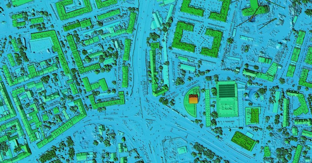
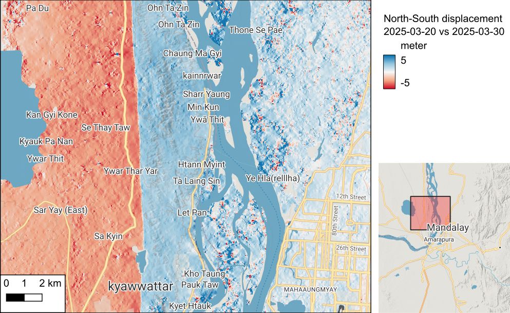
Sentinel-2 reveals the surface deformation after the 2025 #Myanmar #earthquake www.cesbio.cnrs.fr/multitemp/se...
April 2, 2025 at 9:04 PM
Sentinel-2 reveals the surface deformation after the 2025 #Myanmar #earthquake www.cesbio.cnrs.fr/multitemp/se...
"I'm about to write an email to you, please stop what you're doing while I type it out line-by-line into Teams"
March 27, 2025 at 1:54 PM
"I'm about to write an email to you, please stop what you're doing while I type it out line-by-line into Teams"
Reposted

The atomic spectral lines in this app come from the NIST atomic spectroscopy group, which has provided the world with spectroscopic measurements for 120 years.
Today we got word that the federal government is laying off the entire group. 🔭🧪
Today we got word that the federal government is laying off the entire group. 🔭🧪
Tired of wondering which atomic lines are in your spectra? You need:
*whose line is it anyway?* An interactive tool for identifying atomic spectral lines. 🧪🔭 #stars
install:
pip install whoseline
source:
github.com/bmorris3/who...
*whose line is it anyway?* An interactive tool for identifying atomic spectral lines. 🧪🔭 #stars
install:
pip install whoseline
source:
github.com/bmorris3/who...
March 19, 2025 at 5:26 PM
The atomic spectral lines in this app come from the NIST atomic spectroscopy group, which has provided the world with spectroscopic measurements for 120 years.
Today we got word that the federal government is laying off the entire group. 🔭🧪
Today we got word that the federal government is laying off the entire group. 🔭🧪

What Does Trump See in Putin?
A Conversation With Fiona Hill
www.foreignaffairs.com
March 14, 2025 at 11:58 PM
Reposted

This man has cooked his brain on social media and whatever he is taking that keeps him up all night posting

February 12, 2025 at 3:01 PM
This man has cooked his brain on social media and whatever he is taking that keeps him up all night posting
Reposted

When I heard Musk say this on Tuesday, my assumption was that it was a programming issue. Because I can code and have written to databases and because I am familiar with other examples of default values being misinterpreted.
Yet somehow Musk isn't.
Yet somehow Musk isn't.

February 14, 2025 at 1:39 PM
When I heard Musk say this on Tuesday, my assumption was that it was a programming issue. Because I can code and have written to databases and because I am familiar with other examples of default values being misinterpreted.
Yet somehow Musk isn't.
Yet somehow Musk isn't.
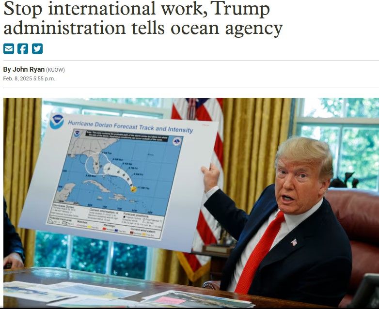
Within NOAA is the National Geodetic Survey, which would be harmed by this. Tracking how the positions on the earth shift requires measurements from throughout the world.
What harm will be done if the NGS is cut off from the IERS, or from collaboration on new North American reference systems?
What harm will be done if the NGS is cut off from the IERS, or from collaboration on new North American reference systems?

Trump administration orders NOAA scientists to halt all international work. Staff were told to stop meetings, discussions, emails with foreign colleagues. Freeze affects travel, virtual meetings, and collaborations until political appointees review them. 🐢🌍🧪🦑
www.opb.org/article/2025...
www.opb.org/article/2025...
February 9, 2025 at 3:04 PM
Within NOAA is the National Geodetic Survey, which would be harmed by this. Tracking how the positions on the earth shift requires measurements from throughout the world.
What harm will be done if the NGS is cut off from the IERS, or from collaboration on new North American reference systems?
What harm will be done if the NGS is cut off from the IERS, or from collaboration on new North American reference systems?
Reposted

NOAA is also responsible for a huge number of global public goods - not just for the US. NOAA data is used around the world for all sorts of Earth and climate sciences, and in disaster relief/humanitarian aid operations. Huge disaster for US soft power and a bigger disaster for real people.

Doge staffers enter Noaa headquarters and incite reports of cuts and threats
Members reportedly sought access to IT systems at agency that Project 2025 has called ‘harmful to US prosperity’
www.theguardian.com
February 5, 2025 at 1:33 PM
NOAA is also responsible for a huge number of global public goods - not just for the US. NOAA data is used around the world for all sorts of Earth and climate sciences, and in disaster relief/humanitarian aid operations. Huge disaster for US soft power and a bigger disaster for real people.
Reposted

A knock-on effect of Musk's closure of USAID is that the Famine Early Warning System (FEWS) is offline. Until this weekend it was one of the best resources into the food security situation in large parts of the world, & provided (as its name suggests) critical foresight into looming famine.


February 3, 2025 at 3:55 PM
A knock-on effect of Musk's closure of USAID is that the Famine Early Warning System (FEWS) is offline. Until this weekend it was one of the best resources into the food security situation in large parts of the world, & provided (as its name suggests) critical foresight into looming famine.