


City Disaster & Emergency Prep
@cdep.bsky.social
A reminder that this state of emergency still obtains. Danger from mudslides and fallen trees will continue for days.
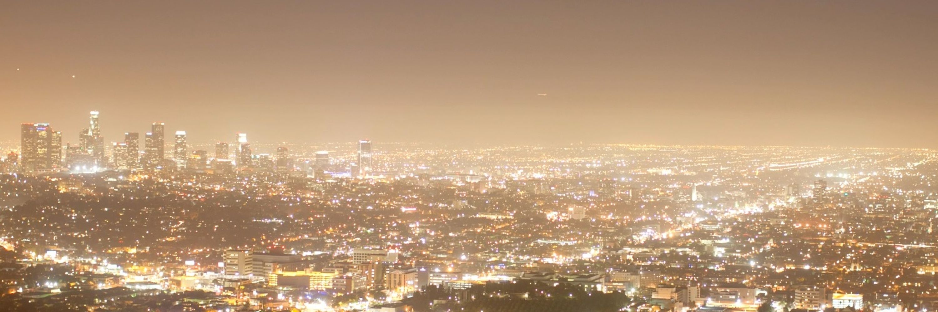
With atmospheric rivers, intense rainfall, and strong winds ahead, I’m declaring a state of emergency in Los Angeles, Orange, Riverside, San Bernardino, San Diego, and Shasta counties to activate emergency authorities and preposition resources to keep our communities safe.
December 26, 2025 at 9:26 PM
A reminder that this state of emergency still obtains. Danger from mudslides and fallen trees will continue for days.
Reposted by City Disaster & Emergency Prep
Rain as of 12/24/25 22:00PT
Red = danger levels
Red = danger levels


December 25, 2025 at 6:04 AM
Rain as of 12/24/25 22:00PT
Red = danger levels
Red = danger levels
Reposted by City Disaster & Emergency Prep

With atmospheric rivers, intense rainfall, and strong winds ahead, I’m declaring a state of emergency in Los Angeles, Orange, Riverside, San Bernardino, San Diego, and Shasta counties to activate emergency authorities and preposition resources to keep our communities safe.
December 24, 2025 at 7:29 PM
With atmospheric rivers, intense rainfall, and strong winds ahead, I’m declaring a state of emergency in Los Angeles, Orange, Riverside, San Bernardino, San Diego, and Shasta counties to activate emergency authorities and preposition resources to keep our communities safe.
Reposted by City Disaster & Emergency Prep

#nws #flood #nwsflashflood #flashfloodwarning Flash Flood Warning for Los Angeles, CA #cawx
FFWLOX
The National Weather Service in Los Angeles/Oxnard has issued a
* Flash Flood Warning for...
Southern Los Angeles County in southwestern California...
* Until 600 […]
[Original post on ai6yr.org]
FFWLOX
The National Weather Service in Los Angeles/Oxnard has issued a
* Flash Flood Warning for...
Southern Los Angeles County in southwestern California...
* Until 600 […]
[Original post on ai6yr.org]

December 24, 2025 at 8:12 PM
#nws #flood #nwsflashflood #flashfloodwarning Flash Flood Warning for Los Angeles, CA #cawx
FFWLOX
The National Weather Service in Los Angeles/Oxnard has issued a
* Flash Flood Warning for...
Southern Los Angeles County in southwestern California...
* Until 600 […]
[Original post on ai6yr.org]
FFWLOX
The National Weather Service in Los Angeles/Oxnard has issued a
* Flash Flood Warning for...
Southern Los Angeles County in southwestern California...
* Until 600 […]
[Original post on ai6yr.org]
Reposted by City Disaster & Emergency Prep

California storm live updates: Updated timeline for worst impacts; 100,000 PG&E customers without power www.sfchronicle.com/weather/arti...

California storm: Updated timeline for worst impacts; 100,000 PG&E customers without power
A massive rainstorm is sweeping across Southern California on a busy travel day. Parts of Orange County were ordered to evacuate amid debris flow risk, while officials warn of rockslides.
www.sfchronicle.com
December 24, 2025 at 8:43 PM
California storm live updates: Updated timeline for worst impacts; 100,000 PG&E customers without power www.sfchronicle.com/weather/arti...
Reposted by City Disaster & Emergency Prep
🚨 STORM SAFETY ALERT – AVOID UNNECESSARY TRAVEL 🚨
Heavy rain, gusty winds, and hazardous road conditions are impacting large parts of California right now.
➡️ Please avoid driving during peak storm conditions unless it’s absolutely necessary.
#StormPrep #StaySafe #TurnAroundDontDrown
Heavy rain, gusty winds, and hazardous road conditions are impacting large parts of California right now.
➡️ Please avoid driving during peak storm conditions unless it’s absolutely necessary.
#StormPrep #StaySafe #TurnAroundDontDrown
December 24, 2025 at 9:45 PM
🚨 STORM SAFETY ALERT – AVOID UNNECESSARY TRAVEL 🚨
Heavy rain, gusty winds, and hazardous road conditions are impacting large parts of California right now.
➡️ Please avoid driving during peak storm conditions unless it’s absolutely necessary.
#StormPrep #StaySafe #TurnAroundDontDrown
Heavy rain, gusty winds, and hazardous road conditions are impacting large parts of California right now.
➡️ Please avoid driving during peak storm conditions unless it’s absolutely necessary.
#StormPrep #StaySafe #TurnAroundDontDrown
Reposted by City Disaster & Emergency Prep
From earlier this morning, FEMA update on the Atmospheric River in the Northwest.
Situation: Last night through this morning brings about the heaviest round of precipitation and wind gusts (FEMA R10
SLB, as of 7:40 p.m. ET, Dec 16). The threats of landslides and […]
[Original post on ai6yr.org]
Situation: Last night through this morning brings about the heaviest round of precipitation and wind gusts (FEMA R10
SLB, as of 7:40 p.m. ET, Dec 16). The threats of landslides and […]
[Original post on ai6yr.org]

December 17, 2025 at 11:20 PM
From earlier this morning, FEMA update on the Atmospheric River in the Northwest.
Situation: Last night through this morning brings about the heaviest round of precipitation and wind gusts (FEMA R10
SLB, as of 7:40 p.m. ET, Dec 16). The threats of landslides and […]
[Original post on ai6yr.org]
Situation: Last night through this morning brings about the heaviest round of precipitation and wind gusts (FEMA R10
SLB, as of 7:40 p.m. ET, Dec 16). The threats of landslides and […]
[Original post on ai6yr.org]
Reposted by City Disaster & Emergency Prep
I wanted to share a few National Weather Service graphics regarding the looming Northern California storms.
Here's how I foresee the Northern California risk level for the next week:
Thursday-Saturday: Minor impact
Sunday-Tuesday: Moderate impact
Wednesday-Thursday: Major impact
#CAwx
Here's how I foresee the Northern California risk level for the next week:
Thursday-Saturday: Minor impact
Sunday-Tuesday: Moderate impact
Wednesday-Thursday: Major impact
#CAwx


December 18, 2025 at 12:09 AM
I wanted to share a few National Weather Service graphics regarding the looming Northern California storms.
Here's how I foresee the Northern California risk level for the next week:
Thursday-Saturday: Minor impact
Sunday-Tuesday: Moderate impact
Wednesday-Thursday: Major impact
#CAwx
Here's how I foresee the Northern California risk level for the next week:
Thursday-Saturday: Minor impact
Sunday-Tuesday: Moderate impact
Wednesday-Thursday: Major impact
#CAwx
Reposted by City Disaster & Emergency Prep
Governor Bob Ferguson (WA)
Information from NWS Seattle:
In coordination with King County, we have issued a FLASH FLOOD WARNING for a levee breach in Tukwila WA near Todd, Blvd. Water is likely moving north towards I-405. In addition, an evacuation notice is now […]
[Original post on ai6yr.org]
Information from NWS Seattle:
In coordination with King County, we have issued a FLASH FLOOD WARNING for a levee breach in Tukwila WA near Todd, Blvd. Water is likely moving north towards I-405. In addition, an evacuation notice is now […]
[Original post on ai6yr.org]

December 15, 2025 at 8:49 PM
Governor Bob Ferguson (WA)
Information from NWS Seattle:
In coordination with King County, we have issued a FLASH FLOOD WARNING for a levee breach in Tukwila WA near Todd, Blvd. Water is likely moving north towards I-405. In addition, an evacuation notice is now […]
[Original post on ai6yr.org]
Information from NWS Seattle:
In coordination with King County, we have issued a FLASH FLOOD WARNING for a levee breach in Tukwila WA near Todd, Blvd. Water is likely moving north towards I-405. In addition, an evacuation notice is now […]
[Original post on ai6yr.org]
Reposted by City Disaster & Emergency Prep
The following IPAWS message is being sent on behalf of King County. Due to a levee breach east of the Green River in Orillia area of Tukwila, Renton, and Kent please evacuate and GO NOW. Go north or south of evacuated area away from flooding waters. If you need […]
[Original post on ai6yr.org]
[Original post on ai6yr.org]

December 15, 2025 at 8:47 PM
The following IPAWS message is being sent on behalf of King County. Due to a levee breach east of the Green River in Orillia area of Tukwila, Renton, and Kent please evacuate and GO NOW. Go north or south of evacuated area away from flooding waters. If you need […]
[Original post on ai6yr.org]
[Original post on ai6yr.org]
Reposted by City Disaster & Emergency Prep
CANDLE SAFETY — HOLIDAY EDITION ✨
Candles add warmth to the season, but they need space to stay safe. Remember to:
🕯 Keep candles in an open space away from flammables
🕯 Never leave them burning unattended
🕯 Place them where kids and pets can’t reach
🕯 Extinguish before leaving the room
Candles add warmth to the season, but they need space to stay safe. Remember to:
🕯 Keep candles in an open space away from flammables
🕯 Never leave them burning unattended
🕯 Place them where kids and pets can’t reach
🕯 Extinguish before leaving the room

December 15, 2025 at 4:16 PM
CANDLE SAFETY — HOLIDAY EDITION ✨
Candles add warmth to the season, but they need space to stay safe. Remember to:
🕯 Keep candles in an open space away from flammables
🕯 Never leave them burning unattended
🕯 Place them where kids and pets can’t reach
🕯 Extinguish before leaving the room
Candles add warmth to the season, but they need space to stay safe. Remember to:
🕯 Keep candles in an open space away from flammables
🕯 Never leave them burning unattended
🕯 Place them where kids and pets can’t reach
🕯 Extinguish before leaving the room
Reposted by City Disaster & Emergency Prep

I love how @erictopol.bsky.social has framed these advancements in autoimmune disease treatment as cancer's mirror biology. A bit dense for lay public, but well worth the read and powers of concentration needed: erictopol.substack.com/p/the-exhili...

The Exhilirating Movement From Treatment to Cures for Autoimmune Diseases
Exploiting Lessons from Cancer's Mirror Biology
erictopol.substack.com
December 15, 2025 at 6:50 PM
I love how @erictopol.bsky.social has framed these advancements in autoimmune disease treatment as cancer's mirror biology. A bit dense for lay public, but well worth the read and powers of concentration needed: erictopol.substack.com/p/the-exhili...
Reposted by City Disaster & Emergency Prep
BBC: Dozens killed in Morocco flash floods
https://www.bbc.com/news/articles/cjwyzlly6eno
#wx #extremeweather #flooding #disasters #climateemergency
https://www.bbc.com/news/articles/cjwyzlly6eno
#wx #extremeweather #flooding #disasters #climateemergency

Morocco floods: Dozens killed in port city of Safi after heavy rains
At least 70 homes have been inundated in Safi's old city centre, officials say.
www.bbc.com
December 15, 2025 at 7:51 PM
BBC: Dozens killed in Morocco flash floods
https://www.bbc.com/news/articles/cjwyzlly6eno
#wx #extremeweather #flooding #disasters #climateemergency
https://www.bbc.com/news/articles/cjwyzlly6eno
#wx #extremeweather #flooding #disasters #climateemergency
Reposted by City Disaster & Emergency Prep
The National Weather Service in Seattle just issued a flash flood warning for portions of Kent, Renton and Tukwila along the Green River, Duwamish Waterway and Cedar River. The Green River levee has failed.
If you are in a low-lying area "move to higher ground now. Act quickly to protect your life"
If you are in a low-lying area "move to higher ground now. Act quickly to protect your life"

SEW issues Flash Flood Warning [flash flood: observed, flash flood damage threat: considerable, dam failure: occurring] for King [WA] till Dec 15, 9:00 PM PST Link

December 15, 2025 at 7:59 PM
The National Weather Service in Seattle just issued a flash flood warning for portions of Kent, Renton and Tukwila along the Green River, Duwamish Waterway and Cedar River. The Green River levee has failed.
If you are in a low-lying area "move to higher ground now. Act quickly to protect your life"
If you are in a low-lying area "move to higher ground now. Act quickly to protect your life"
Reposted by City Disaster & Emergency Prep

Brown University now says police do NOT have a shooting suspect in custody and that community members should continue to shelter in place.

December 13, 2025 at 10:17 PM
Brown University now says police do NOT have a shooting suspect in custody and that community members should continue to shelter in place.
Reposted by City Disaster & Emergency Prep

Barus & Holley is the Physics building at Brown.
Brown University now says police do NOT have a shooting suspect in custody and that community members should continue to shelter in place.
December 13, 2025 at 10:41 PM
Barus & Holley is the Physics building at Brown.
Reposted by City Disaster & Emergency Prep

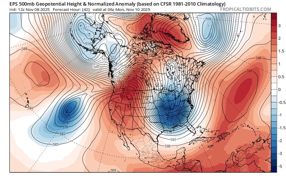
A high-amplitude flow pattern, characterized by near-record strength ridging and troughing (respectively) over the western and eastern U.S. and a very wavy jet stream, will bring a progression of notable weather to North America in the coming days.
November 8, 2025 at 11:19 PM
A high-amplitude flow pattern, characterized by near-record strength ridging and troughing (respectively) over the western and eastern U.S. and a very wavy jet stream, will bring a progression of notable weather to North America in the coming days.
Reposted by City Disaster & Emergency Prep

Typhoon Uwan / Fung-wong from development to landfall near Dinalungan in Luzon, Philippines 🇵🇭🌀
November 9, 2025 at 4:35 PM
Typhoon Uwan / Fung-wong from development to landfall near Dinalungan in Luzon, Philippines 🇵🇭🌀
Reposted by City Disaster & Emergency Prep
Wildfires aren’t necessarily happening more often, but they are becoming more intense.
A new international study shows that hotter, drier conditions are making it easier for fires to spread rapidly once they begin.
phys.org/news/2025-10...
1/2
#WildfireResearch
A new international study shows that hotter, drier conditions are making it easier for fires to spread rapidly once they begin.
phys.org/news/2025-10...
1/2
#WildfireResearch

Experts reveal climate change drove extreme wildfire seasons across the Americas, making burned areas much larger
Human-driven climate change made wildfires in parts of South America and Southern California many times larger and more destructive, according to an annual assessment by international experts.
phys.org
November 9, 2025 at 5:15 PM
Wildfires aren’t necessarily happening more often, but they are becoming more intense.
A new international study shows that hotter, drier conditions are making it easier for fires to spread rapidly once they begin.
phys.org/news/2025-10...
1/2
#WildfireResearch
A new international study shows that hotter, drier conditions are making it easier for fires to spread rapidly once they begin.
phys.org/news/2025-10...
1/2
#WildfireResearch
Reposted by City Disaster & Emergency Prep

⚒️ 🧪
A M6.8 earthquake struck offshore Japan today - another large earthquake from the subduction zone that produced two recent great earthquakes. The earthquake was preceded by a "cascade up": foreshocks progressively increasing in maximum magnitude.
What do we know? What might happen next?
A M6.8 earthquake struck offshore Japan today - another large earthquake from the subduction zone that produced two recent great earthquakes. The earthquake was preceded by a "cascade up": foreshocks progressively increasing in maximum magnitude.
What do we know? What might happen next?

M6.8 earthquake offshore Japan preceded by upward cascade of foreshocks
What do we know about seismic hazard in the Japan-Kuril subduction zone?
earthquakeinsights.substack.com
November 9, 2025 at 6:41 PM
⚒️ 🧪
A M6.8 earthquake struck offshore Japan today - another large earthquake from the subduction zone that produced two recent great earthquakes. The earthquake was preceded by a "cascade up": foreshocks progressively increasing in maximum magnitude.
What do we know? What might happen next?
A M6.8 earthquake struck offshore Japan today - another large earthquake from the subduction zone that produced two recent great earthquakes. The earthquake was preceded by a "cascade up": foreshocks progressively increasing in maximum magnitude.
What do we know? What might happen next?
Reposted by City Disaster & Emergency Prep

Shelter in place advised in Yazoo City, Mississippi, after an explosion at the CF ammonia plant. www.wlbt.com/2025/11/05/resid...

No injuries reported in Yazoo Co. ammonia plant explosion, company says
Red Cross opens center to help those impacted by explosion.
www.wlbt.com
November 6, 2025 at 1:46 AM
Shelter in place advised in Yazoo City, Mississippi, after an explosion at the CF ammonia plant. www.wlbt.com/2025/11/05/resid...
Reposted by City Disaster & Emergency Prep
The sun is ULTRA active right now, two X flares today and multiple CMEs! While not directly pointed at earth, we might still see some impacts. I hope these ARs keep it up as they rotate toward earth!

November 4, 2025 at 11:34 PM
The sun is ULTRA active right now, two X flares today and multiple CMEs! While not directly pointed at earth, we might still see some impacts. I hope these ARs keep it up as they rotate toward earth!
Reposted by City Disaster & Emergency Prep
Thread below, jumping in to listen to Louisville fire scanner on the UPS crash at SDF... feel free to mute, will tag it at #ups2976 #sdf #planecrash #aviation
November 4, 2025 at 11:37 PM
Thread below, jumping in to listen to Louisville fire scanner on the UPS crash at SDF... feel free to mute, will tag it at #ups2976 #sdf #planecrash #aviation
Reposted by City Disaster & Emergency Prep
A powerful storm system is expected to impact Northern California from Tuesday through Thursday, bringing strong winds and heavy rainfall.
Stay alert for changing conditions and follow updates from local authorities. #CAwx #WeatherUpdate
Stay alert for changing conditions and follow updates from local authorities. #CAwx #WeatherUpdate
November 5, 2025 at 12:35 AM
A powerful storm system is expected to impact Northern California from Tuesday through Thursday, bringing strong winds and heavy rainfall.
Stay alert for changing conditions and follow updates from local authorities. #CAwx #WeatherUpdate
Stay alert for changing conditions and follow updates from local authorities. #CAwx #WeatherUpdate