


Deelan Jariwala
@wxtca.bsky.social
Does a lot of stuff with the tropics and not much else. TCs are cool
UM ‘26
UM ‘26
Reposted by Deelan Jariwala
With about 80% of the precincts reporting I've seen enough. GDMI - Google DeepMind is going to win the seat for best track model in 2025. The race for best intensity model is still too close to call, but GDMI is right there with the consensus and OFCL. Quite a remarkable campaign.


October 13, 2025 at 2:45 PM
With about 80% of the precincts reporting I've seen enough. GDMI - Google DeepMind is going to win the seat for best track model in 2025. The race for best intensity model is still too close to call, but GDMI is right there with the consensus and OFCL. Quite a remarkable campaign.
Reposted by Deelan Jariwala

Yesterday, #Podul moved over #Taiwan as a 95 kt #typhoon.
A unique feature seen w/ TCs near Taiwan is a blowup of seemingly cold convection (<-80C) as core moves over the island.
Turns out it's mostly thick cirrus w/o much sfc precip due to vertically propagating mountain waves. Diagnosed below⤵️
A unique feature seen w/ TCs near Taiwan is a blowup of seemingly cold convection (<-80C) as core moves over the island.
Turns out it's mostly thick cirrus w/o much sfc precip due to vertically propagating mountain waves. Diagnosed below⤵️
August 14, 2025 at 3:55 PM
Further west ensemble members have stronger ridging over the eastern half of North America. However, members with stronger ridging in this region also tend to have a more intense system over the southwestern Atlantic! HAFS-A shows that this is a product of flow becoming more WNW with height.


August 14, 2025 at 5:05 AM
Further west ensemble members have stronger ridging over the eastern half of North America. However, members with stronger ridging in this region also tend to have a more intense system over the southwestern Atlantic! HAFS-A shows that this is a product of flow becoming more WNW with height.
Reposted by Deelan Jariwala
I'd like list a couple pet peeves of mine that regular folks & professional mets have done this #hurricane season that is poor form:
(1) Naming storms before they are actually named.
(2) Sharing deterministic model forecasts (including AI models) beyond 5-7 days.
Allow me a mini-rant to explain:🧵
(1) Naming storms before they are actually named.
(2) Sharing deterministic model forecasts (including AI models) beyond 5-7 days.
Allow me a mini-rant to explain:🧵
August 10, 2025 at 2:18 PM
I'd like list a couple pet peeves of mine that regular folks & professional mets have done this #hurricane season that is poor form:
(1) Naming storms before they are actually named.
(2) Sharing deterministic model forecasts (including AI models) beyond 5-7 days.
Allow me a mini-rant to explain:🧵
(1) Naming storms before they are actually named.
(2) Sharing deterministic model forecasts (including AI models) beyond 5-7 days.
Allow me a mini-rant to explain:🧵
Reposted by Deelan Jariwala
😬 yeah unfortunately ATMS does not have enough horizontal res needed to resolve inner core features in TCs like #Erick.
Nice TS Storms post by Naufal Razin shows footprint of SSMIS imagers on overall TC microwave coverage.
Microwave coverage peaked in 2015, w/ SSMIS ~60% of current coverage data.
Nice TS Storms post by Naufal Razin shows footprint of SSMIS imagers on overall TC microwave coverage.
Microwave coverage peaked in 2015, w/ SSMIS ~60% of current coverage data.


June 27, 2025 at 9:40 PM
😬 yeah unfortunately ATMS does not have enough horizontal res needed to resolve inner core features in TCs like #Erick.
Nice TS Storms post by Naufal Razin shows footprint of SSMIS imagers on overall TC microwave coverage.
Microwave coverage peaked in 2015, w/ SSMIS ~60% of current coverage data.
Nice TS Storms post by Naufal Razin shows footprint of SSMIS imagers on overall TC microwave coverage.
Microwave coverage peaked in 2015, w/ SSMIS ~60% of current coverage data.
This is a pretty strange and uncalled-for reaction to someone making a valid point about that seasonal forecast! A statistical model, as described in Kozar et al. 2012 and used in the UPenn forecast, will tend to struggle when provided with data outside of its training dataset (I.E. extrapolation).
April 28, 2025 at 8:34 PM
This is a pretty strange and uncalled-for reaction to someone making a valid point about that seasonal forecast! A statistical model, as described in Kozar et al. 2012 and used in the UPenn forecast, will tend to struggle when provided with data outside of its training dataset (I.E. extrapolation).
Reposted by Deelan Jariwala

BREAKING from @science.org: The Trump admin is seeking to kill nearly all climate research at NOAA, its climate science agency.
Its near-final budget proposal would end all NOAA research labs, academic institutes, and regional climate centers. And it wants to fully end the NOAA Research division.
Its near-final budget proposal would end all NOAA research labs, academic institutes, and regional climate centers. And it wants to fully end the NOAA Research division.
Trump seeks to end climate research at premier U.S. climate agency
White House aims to end NOAA’s research office; NASA also targeted
www.science.org
April 11, 2025 at 3:20 PM
BREAKING from @science.org: The Trump admin is seeking to kill nearly all climate research at NOAA, its climate science agency.
Its near-final budget proposal would end all NOAA research labs, academic institutes, and regional climate centers. And it wants to fully end the NOAA Research division.
Its near-final budget proposal would end all NOAA research labs, academic institutes, and regional climate centers. And it wants to fully end the NOAA Research division.
Satellite loop of Hurricane Carmen (1974) rapidly intensifying over the Gulf of Mexico, as well as its landfall and decay over Louisiana. These pictures, taken by SMS-1, are some of the earliest examples of enhanced longwave infrared imagery that I know of.
January 29, 2025 at 10:22 PM
Satellite loop of Hurricane Carmen (1974) rapidly intensifying over the Gulf of Mexico, as well as its landfall and decay over Louisiana. These pictures, taken by SMS-1, are some of the earliest examples of enhanced longwave infrared imagery that I know of.
Reposted by Deelan Jariwala
Original thread worthy of an update to show evolution of this low on IR from 19 to 22 December.
An attempt at #tropical #transition was made, but as it shed frontal features, marginal SSTs prolonged length it took for organized deep convection to develop, & window was too short for classification.
An attempt at #tropical #transition was made, but as it shed frontal features, marginal SSTs prolonged length it took for organized deep convection to develop, & window was too short for classification.
December 23, 2024 at 9:06 PM
Original thread worthy of an update to show evolution of this low on IR from 19 to 22 December.
An attempt at #tropical #transition was made, but as it shed frontal features, marginal SSTs prolonged length it took for organized deep convection to develop, & window was too short for classification.
An attempt at #tropical #transition was made, but as it shed frontal features, marginal SSTs prolonged length it took for organized deep convection to develop, & window was too short for classification.
Probably not likely to go anywhere interesting, but it’ll be interesting to watch one or more cut off lows in the central Atlantic over the next week as they meander over the subtropics south of strong ridging.

December 16, 2024 at 7:06 PM
Probably not likely to go anywhere interesting, but it’ll be interesting to watch one or more cut off lows in the central Atlantic over the next week as they meander over the subtropics south of strong ridging.
Hello from an alien drone over New Jersey

December 15, 2024 at 9:34 PM
Hello from an alien drone over New Jersey
Pretty cool to see the change in the global circulation in response to the strengthening La Niña here on a longer-term VP200 hovmoller. Previously, the MJO signal was pretty robust and circuited the world every month or so. Recently though, it’s been parked over the Indian Ocean.

December 7, 2024 at 5:36 AM
Pretty cool to see the change in the global circulation in response to the strengthening La Niña here on a longer-term VP200 hovmoller. Previously, the MJO signal was pretty robust and circuited the world every month or so. Recently though, it’s been parked over the Indian Ocean.
Reposted by Deelan Jariwala

Storm-resolving climate models project a 36% increase in the year-to-year variability of Atlantic hurricane activity by the 2050s 🌊🧪: ocean2climate.org/2024/11/30/s...

November 30, 2024 at 1:17 PM
Storm-resolving climate models project a 36% increase in the year-to-year variability of Atlantic hurricane activity by the 2050s 🌊🧪: ocean2climate.org/2024/11/30/s...
It's worth noting that the last 15 or so years have seen a marked decline in Atlantic ACE in the latter part of July and the bulk of August, contrasting with an increase in June and a larger rise in October. This is interesting to consider in the context of this year which saw a similar pattern.


November 28, 2024 at 10:49 AM
It's worth noting that the last 15 or so years have seen a marked decline in Atlantic ACE in the latter part of July and the bulk of August, contrasting with an increase in June and a larger rise in October. This is interesting to consider in the context of this year which saw a similar pattern.
Perhaps a long shot, but is there an archive anywhere online for VHRR data?
November 23, 2024 at 9:16 PM
Perhaps a long shot, but is there an archive anywhere online for VHRR data?
Reposted by Deelan Jariwala

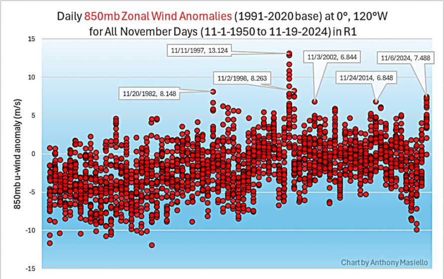
The westerly wind burst earlier in the month was pretty strong and is worth a further dive into the data/better analysis. Quick glance at Reanalysis daily data in Nov, for the equatorial 850mb zonal wind anomaly at 120°W since 1950, shows it was the strongest since the 1997 and 1998 November events.
November 21, 2024 at 9:14 PM
The westerly wind burst earlier in the month was pretty strong and is worth a further dive into the data/better analysis. Quick glance at Reanalysis daily data in Nov, for the equatorial 850mb zonal wind anomaly at 120°W since 1950, shows it was the strongest since the 1997 and 1998 November events.
Some cool imagery of Hurricane Carmen (1974) approaching its first peak in the Gulf of Honduras. The second and third image are from the VHRR instrument aboard some of NOAA’s early polar orbiting satellites — I had no idea this data existed with such high quality!!


November 16, 2024 at 9:52 PM
Some cool imagery of Hurricane Carmen (1974) approaching its first peak in the Gulf of Honduras. The second and third image are from the VHRR instrument aboard some of NOAA’s early polar orbiting satellites — I had no idea this data existed with such high quality!!
Probably not something I’d post on Twitter, but it’s really funny that the long range GFS throws a TPV lobe into the U.S. and only manages to drop temperatures to near normal. The preceding airmass is just ridiculously warm for December.


December 20, 2023 at 4:40 AM
Probably not something I’d post on Twitter, but it’s really funny that the long range GFS throws a TPV lobe into the U.S. and only manages to drop temperatures to near normal. The preceding airmass is just ridiculously warm for December.
Not necessarily on this platform, but there’s been a silly amount of cope regarding the prospects of a warm December elsewhere. It started out as denying the strength of the El Niño event, before transitioning over to denying the incoming jet extension as we got closer. Just plain weird.
December 17, 2023 at 2:23 PM
Not necessarily on this platform, but there’s been a silly amount of cope regarding the prospects of a warm December elsewhere. It started out as denying the strength of the El Niño event, before transitioning over to denying the incoming jet extension as we got closer. Just plain weird.
Disheartening to see some anonymous scumbag on wxtwitter try to falsify awful screenshots of me. Don’t even know what I did to deserve that lol
September 21, 2023 at 3:54 PM
Disheartening to see some anonymous scumbag on wxtwitter try to falsify awful screenshots of me. Don’t even know what I did to deserve that lol