


Deelan Jariwala
@wxtca.bsky.social
Does a lot of stuff with the tropics and not much else. TCs are cool
UM ‘26
UM ‘26
Further west ensemble members have stronger ridging over the eastern half of North America. However, members with stronger ridging in this region also tend to have a more intense system over the southwestern Atlantic! HAFS-A shows that this is a product of flow becoming more WNW with height.


August 14, 2025 at 5:05 AM
Further west ensemble members have stronger ridging over the eastern half of North America. However, members with stronger ridging in this region also tend to have a more intense system over the southwestern Atlantic! HAFS-A shows that this is a product of flow becoming more WNW with height.
Are those what became these plots? The TC real-time model products are severely underrated imo

August 14, 2025 at 4:55 AM
Are those what became these plots? The TC real-time model products are severely underrated imo
Aaaand I was immediately blocked for this quote-retweet. Really weird behavior, lol

April 28, 2025 at 8:42 PM
Aaaand I was immediately blocked for this quote-retweet. Really weird behavior, lol
Closest to band 7 today -- it would be cool if you could visualize these with more modern colortables and whatnot but I don't think the actual data files are extant (or at least don't exist in a format that can easily be read)

January 29, 2025 at 10:38 PM
Closest to band 7 today -- it would be cool if you could visualize these with more modern colortables and whatnot but I don't think the actual data files are extant (or at least don't exist in a format that can easily be read)
Satellite loop of Hurricane Carmen (1974) rapidly intensifying over the Gulf of Mexico, as well as its landfall and decay over Louisiana. These pictures, taken by SMS-1, are some of the earliest examples of enhanced longwave infrared imagery that I know of.
January 29, 2025 at 10:22 PM
Satellite loop of Hurricane Carmen (1974) rapidly intensifying over the Gulf of Mexico, as well as its landfall and decay over Louisiana. These pictures, taken by SMS-1, are some of the earliest examples of enhanced longwave infrared imagery that I know of.
Seems like it comes down to where the NPAC jet deposits a ridge in some regards (is it in the Gulf of Alaska poleward or the Western US/near the coast?). We'll see how this plays out but with the MJO crossing into the Pacific, I'd probably lean towards the ECMWF knowing the GFS's habits here.

December 24, 2024 at 12:37 AM
Seems like it comes down to where the NPAC jet deposits a ridge in some regards (is it in the Gulf of Alaska poleward or the Western US/near the coast?). We'll see how this plays out but with the MJO crossing into the Pacific, I'd probably lean towards the ECMWF knowing the GFS's habits here.
And not because I expect this to overperform...

December 20, 2024 at 2:52 AM
And not because I expect this to overperform...
Probably not likely to go anywhere interesting, but it’ll be interesting to watch one or more cut off lows in the central Atlantic over the next week as they meander over the subtropics south of strong ridging.

December 16, 2024 at 7:06 PM
Probably not likely to go anywhere interesting, but it’ll be interesting to watch one or more cut off lows in the central Atlantic over the next week as they meander over the subtropics south of strong ridging.
Hello from an alien drone over New Jersey

December 15, 2024 at 9:34 PM
Hello from an alien drone over New Jersey
The result has been a prolonged period of easterly trade winds over the equatorial Pacific and westerlies over the Indian Ocean. The latter has resulted in significant cooling, as well as multiple tropical cyclones (including some more to come).


December 7, 2024 at 5:36 AM
The result has been a prolonged period of easterly trade winds over the equatorial Pacific and westerlies over the Indian Ocean. The latter has resulted in significant cooling, as well as multiple tropical cyclones (including some more to come).
Pretty cool to see the change in the global circulation in response to the strengthening La Niña here on a longer-term VP200 hovmoller. Previously, the MJO signal was pretty robust and circuited the world every month or so. Recently though, it’s been parked over the Indian Ocean.

December 7, 2024 at 5:36 AM
Pretty cool to see the change in the global circulation in response to the strengthening La Niña here on a longer-term VP200 hovmoller. Previously, the MJO signal was pretty robust and circuited the world every month or so. Recently though, it’s been parked over the Indian Ocean.
Two alternative ways to visualize this that better emphasize the scale of the changes here -- while there has indeed been a shift, the distribution of ACE in the Atlantic remains more or less the same. Mid September is still the most active part of the hurricane season.


November 28, 2024 at 8:35 PM
Two alternative ways to visualize this that better emphasize the scale of the changes here -- while there has indeed been a shift, the distribution of ACE in the Atlantic remains more or less the same. Mid September is still the most active part of the hurricane season.
It's worth noting that the last 15 or so years have seen a marked decline in Atlantic ACE in the latter part of July and the bulk of August, contrasting with an increase in June and a larger rise in October. This is interesting to consider in the context of this year which saw a similar pattern.


November 28, 2024 at 10:49 AM
It's worth noting that the last 15 or so years have seen a marked decline in Atlantic ACE in the latter part of July and the bulk of August, contrasting with an increase in June and a larger rise in October. This is interesting to consider in the context of this year which saw a similar pattern.
Some cool imagery of Hurricane Carmen (1974) approaching its first peak in the Gulf of Honduras. The second and third image are from the VHRR instrument aboard some of NOAA’s early polar orbiting satellites — I had no idea this data existed with such high quality!!


November 16, 2024 at 9:52 PM
Some cool imagery of Hurricane Carmen (1974) approaching its first peak in the Gulf of Honduras. The second and third image are from the VHRR instrument aboard some of NOAA’s early polar orbiting satellites — I had no idea this data existed with such high quality!!
Probably not entirely a coincidence that the SST pattern is becoming a lot less favorable as we move out from the peak of the West African Monsoon. It’s almost like inflow into that circulation and the associated MDR warming masked the impact of the +NAO on the tropics.


September 16, 2024 at 1:14 PM
Probably not entirely a coincidence that the SST pattern is becoming a lot less favorable as we move out from the peak of the West African Monsoon. It’s almost like inflow into that circulation and the associated MDR warming masked the impact of the +NAO on the tropics.
I'm not sure how significant this is, but the 4th EOF of low-level winds in this area (best described as a low centered on the coast) seems to produce some unusually high PC values for August 2024. Could translate to increased flux of the aforementioned stable air into new TWs?

September 6, 2024 at 6:58 PM
I'm not sure how significant this is, but the 4th EOF of low-level winds in this area (best described as a low centered on the coast) seems to produce some unusually high PC values for August 2024. Could translate to increased flux of the aforementioned stable air into new TWs?
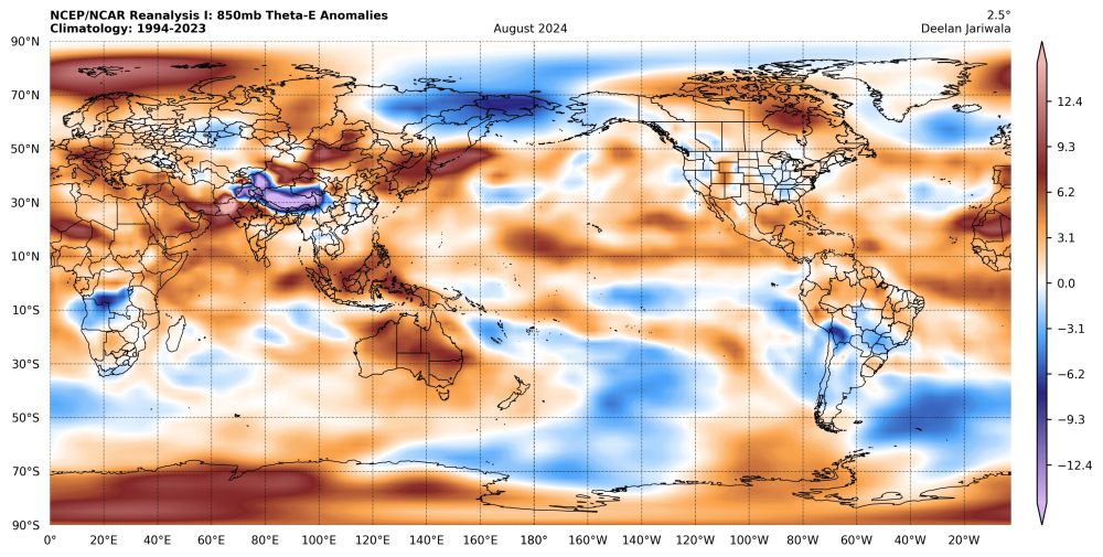
I posted this over on the other site but I figure I should tack it on here too because I wasn't really sure if using flat 200mb temperatures was the best measure of stability in the tropics (lots of moisture...)
500mb and 850mb theta-e anomalies, as well as the difference between them.
500mb and 850mb theta-e anomalies, as well as the difference between them.


September 6, 2024 at 6:52 PM
I posted this over on the other site but I figure I should tack it on here too because I wasn't really sure if using flat 200mb temperatures was the best measure of stability in the tropics (lots of moisture...)
500mb and 850mb theta-e anomalies, as well as the difference between them.
500mb and 850mb theta-e anomalies, as well as the difference between them.
I think we’ll probably get a -NAO eventually through this pathway but it might take a little while. Models show the TPV planted right over Greenland, surrounded by blocking on all sides with nowhere to go…


January 19, 2024 at 7:00 AM
I think we’ll probably get a -NAO eventually through this pathway but it might take a little while. Models show the TPV planted right over Greenland, surrounded by blocking on all sides with nowhere to go…
I’d like to think I ended up on the good side of the gradient — never really changed over to sleet, but garbage ratios made up for it


January 7, 2024 at 6:02 PM
I’d like to think I ended up on the good side of the gradient — never really changed over to sleet, but garbage ratios made up for it
I’d bet someone would get some pretty epic snow squalls out of this sort of set up — those lapse rates are just silly:

December 20, 2023 at 4:54 AM
I’d bet someone would get some pretty epic snow squalls out of this sort of set up — those lapse rates are just silly:
Probably not something I’d post on Twitter, but it’s really funny that the long range GFS throws a TPV lobe into the U.S. and only manages to drop temperatures to near normal. The preceding airmass is just ridiculously warm for December.


December 20, 2023 at 4:40 AM
Probably not something I’d post on Twitter, but it’s really funny that the long range GFS throws a TPV lobe into the U.S. and only manages to drop temperatures to near normal. The preceding airmass is just ridiculously warm for December.
I think there’s a legitimate argument in claiming that this ENSO event is not exactly traditional atmospherically speaking, but I don’t think it’s rooted in the MEI or anything. There’s only been a handful of years, El Niño or not, with such a well defined wavenumber 2 VP200 pattern:


December 17, 2023 at 2:28 PM
I think there’s a legitimate argument in claiming that this ENSO event is not exactly traditional atmospherically speaking, but I don’t think it’s rooted in the MEI or anything. There’s only been a handful of years, El Niño or not, with such a well defined wavenumber 2 VP200 pattern: