


Dan Dawson
@meteodan.bsky.social
Associate Professor of Meteorology at Purdue University. Husband, father, and storm chaser. Nondenominational Christian. Insufferable centrist. I would like to keep my Republic. Opinions my own.
Reposted by Dan Dawson

Huge, Earth-directed coronal mass ejection now en route. Geomagnetic Storm Watch (G4-level) in effect.
"Watches at this level are very rare," says NOAA.
Could be substantial aurora displays on Mon night 1/19-1/20, even as far south as NoCal > Alabama.
www.swpc.noaa.gov/news/g4-seve...
"Watches at this level are very rare," says NOAA.
Could be substantial aurora displays on Mon night 1/19-1/20, even as far south as NoCal > Alabama.
www.swpc.noaa.gov/news/g4-seve...
January 19, 2026 at 5:23 PM
Huge, Earth-directed coronal mass ejection now en route. Geomagnetic Storm Watch (G4-level) in effect.
"Watches at this level are very rare," says NOAA.
Could be substantial aurora displays on Mon night 1/19-1/20, even as far south as NoCal > Alabama.
www.swpc.noaa.gov/news/g4-seve...
"Watches at this level are very rare," says NOAA.
Could be substantial aurora displays on Mon night 1/19-1/20, even as far south as NoCal > Alabama.
www.swpc.noaa.gov/news/g4-seve...
Reposted by Dan Dawson

Protesting government overreach is not insurrection.
They are not preventing ICE from doing immigration enforcement.
They are objecting to an out-of-control agency that continually lies to the public and does harm.
They are not preventing ICE from doing immigration enforcement.
They are objecting to an out-of-control agency that continually lies to the public and does harm.

Trump threatens to invoke the Insurrection Act in Minnesota in a post on Truth Social.

January 15, 2026 at 2:12 PM
Protesting government overreach is not insurrection.
They are not preventing ICE from doing immigration enforcement.
They are objecting to an out-of-control agency that continually lies to the public and does harm.
They are not preventing ICE from doing immigration enforcement.
They are objecting to an out-of-control agency that continually lies to the public and does harm.
About to /ragequit over trying to make all my PDF slides created from LaTeX (full of equations) accessible for screen readers, etc. to be ADA compliant...
And the first person who says "Use PowerPoint" in my replies gets the stink eye....
And the first person who says "Use PowerPoint" in my replies gets the stink eye....

a man in a green shirt is sitting on a couch and eating a bag of food .
ALT: a man in a green shirt is sitting on a couch and eating a bag of food .
media.tenor.com
January 9, 2026 at 9:26 PM
About to /ragequit over trying to make all my PDF slides created from LaTeX (full of equations) accessible for screen readers, etc. to be ADA compliant...
And the first person who says "Use PowerPoint" in my replies gets the stink eye....
And the first person who says "Use PowerPoint" in my replies gets the stink eye....
I should be careful here myself! An AI image generator shouldn’t naively be lumped in with LLMs like I just did…
Hopefully my larger point still came across, however tinged with irony it was!
Hopefully my larger point still came across, however tinged with irony it was!
Unfortunately such conflating of LLMs with other uses of AI is seemingly already pretty well entrenched in the minds of many. This sort of incident where the NWS is using LLMs and not checking for gaffes is only going to muddy the waters further, I fear.

*inhales*
AI is a blanket term. It's not the same thing as using generative AI (images/videos from prompts) or large language models (LLMs; text from prompts).
It's misleading to say "AI" when genAI or LLMs are the actual tools being used.
The IMAGE was generated here, not the FORECAST.
AI is a blanket term. It's not the same thing as using generative AI (images/videos from prompts) or large language models (LLMs; text from prompts).
It's misleading to say "AI" when genAI or LLMs are the actual tools being used.
The IMAGE was generated here, not the FORECAST.
January 7, 2026 at 4:17 PM
I should be careful here myself! An AI image generator shouldn’t naively be lumped in with LLMs like I just did…
Hopefully my larger point still came across, however tinged with irony it was!
Hopefully my larger point still came across, however tinged with irony it was!
Unfortunately such conflating of LLMs with other uses of AI is seemingly already pretty well entrenched in the minds of many. This sort of incident where the NWS is using LLMs and not checking for gaffes is only going to muddy the waters further, I fear.
*inhales*
AI is a blanket term. It's not the same thing as using generative AI (images/videos from prompts) or large language models (LLMs; text from prompts).
It's misleading to say "AI" when genAI or LLMs are the actual tools being used.
The IMAGE was generated here, not the FORECAST.
AI is a blanket term. It's not the same thing as using generative AI (images/videos from prompts) or large language models (LLMs; text from prompts).
It's misleading to say "AI" when genAI or LLMs are the actual tools being used.
The IMAGE was generated here, not the FORECAST.

The National Weather Service used AI to create a forecast for Idaho. Low chances of wind for the nonexistent towns of Cocrerrireod, Orangeotild and Whata Bod www.washingtonpost.com/weather/2026...
January 7, 2026 at 4:09 PM
Unfortunately such conflating of LLMs with other uses of AI is seemingly already pretty well entrenched in the minds of many. This sort of incident where the NWS is using LLMs and not checking for gaffes is only going to muddy the waters further, I fear.
Reposted by Dan Dawson

December 28, 2025 at 9:55 PM
Starting to get concerned about a low-topped supercell tornado threat here later today. Here's a 15Z HRRR sounding valid 23Z just ahead of the line in Tippecanoe County. Main negative I see is a stable layer near the surface:

December 28, 2025 at 4:41 PM
Starting to get concerned about a low-topped supercell tornado threat here later today. Here's a 15Z HRRR sounding valid 23Z just ahead of the line in Tippecanoe County. Main negative I see is a stable layer near the surface:
That’s… not great.

“In short, the atomic ensemble time scale at our Boulder campus has failed due to a prolonged utility power outage. One impact is that the Boulder Internet Time Services no longer have an accurate time reference.”
groups.google.com/a/list.nist....
groups.google.com/a/list.nist....
Primary time scale failure at NIST Boulder campus; significant impact on NTP services
groups.google.com
December 20, 2025 at 5:57 PM
That’s… not great.
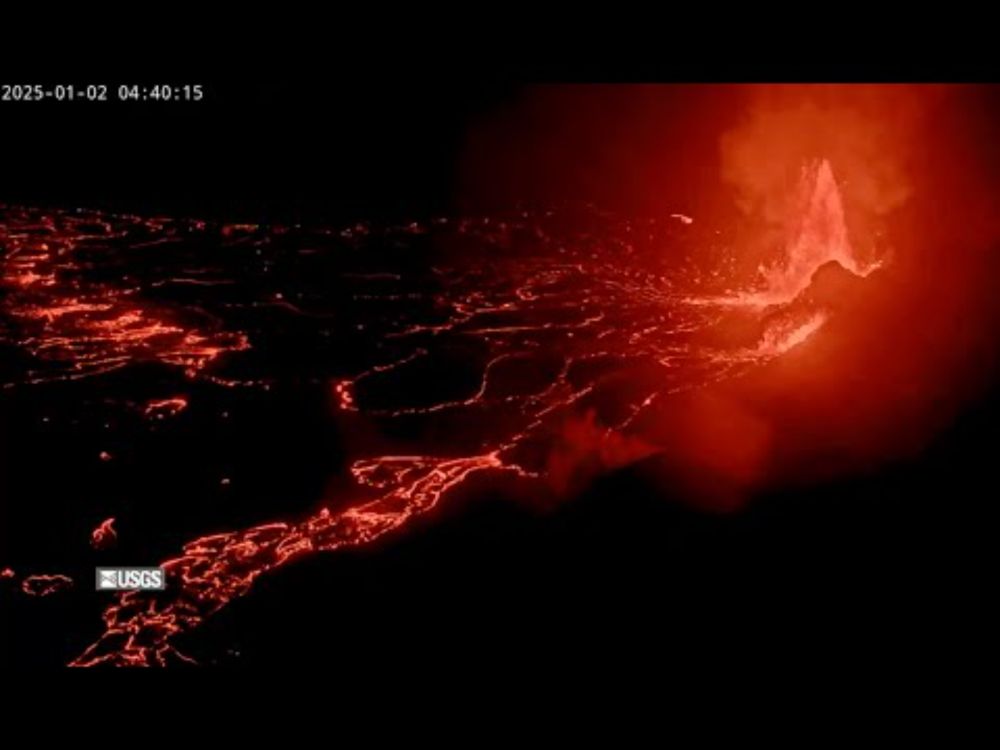
I sooooo wish I had been watching this in real time. As it is, I’ve been scrolling back and watching the final moments multiple times. Unbelievable, and possibly unprecedented footage. The fact that the camera hangs on for a few more seconds after getting buried with lava…👀
Here's the progression of the camera getting hit
December 7, 2025 at 2:26 AM
I sooooo wish I had been watching this in real time. As it is, I’ve been scrolling back and watching the final moments multiple times. Unbelievable, and possibly unprecedented footage. The fact that the camera hangs on for a few more seconds after getting buried with lava…👀
How not to extract and plot a sounding from RAP model output. At least I made some progress this evening. Earlier I couldn't even get the data read in. This notebook *used* to work; but something apparently changed in the output in the last couple of years. Time to figure out what...

December 4, 2025 at 12:12 AM
How not to extract and plot a sounding from RAP model output. At least I made some progress this evening. Earlier I couldn't even get the data read in. This notebook *used* to work; but something apparently changed in the output in the last couple of years. Time to figure out what...
Reposted by Dan Dawson

Today's Dec. 3 snowcover in the U.S. is the 2nd highest since 2006 according to NOHRSC at 40.3%. Record was 45.5% on Dec. 3, 2019.

December 3, 2025 at 2:15 PM
Today's Dec. 3 snowcover in the U.S. is the 2nd highest since 2006 according to NOHRSC at 40.3%. Record was 45.5% on Dec. 3, 2019.
Reposted by Dan Dawson

@hebrooks87.bsky.social with a stirring tribute to the late Chuck Doswell at #ECSS. Chuck’s legacy lives on in his lasting ingredients-based flash flooding teachings.

November 19, 2025 at 11:16 AM
@hebrooks87.bsky.social with a stirring tribute to the late Chuck Doswell at #ECSS. Chuck’s legacy lives on in his lasting ingredients-based flash flooding teachings.

Just when I was about to go back inside! Aurora all quads!


November 12, 2025 at 4:57 AM
Just when I was about to go back inside! Aurora all quads!


"The wind in the wires made a tattle-tale sound, and a wave broke over the railing..."
To the hour and near minute.
"We are holding our own."
"We are holding our own."
November 11, 2025 at 2:26 AM
"The wind in the wires made a tattle-tale sound, and a wave broke over the railing..."
Reposted by Dan Dawson

You scrolled too greedily and too deep.

November 10, 2025 at 6:50 PM
You scrolled too greedily and too deep.
If anyone wonders how my evening is going, here’s a text I just sent to my Mom, divorced of all context for comedic and dramatic effect:
“The fact that Guy Smiley has no teeth in the Google search makes me wonder if the Mandela effect really is true :P”
“The fact that Guy Smiley has no teeth in the Google search makes me wonder if the Mandela effect really is true :P”
November 3, 2025 at 12:47 AM
If anyone wonders how my evening is going, here’s a text I just sent to my Mom, divorced of all context for comedic and dramatic effect:
“The fact that Guy Smiley has no teeth in the Google search makes me wonder if the Mandela effect really is true :P”
“The fact that Guy Smiley has no teeth in the Google search makes me wonder if the Mandela effect really is true :P”
Reposted by Dan Dawson

Thanks to some vigilant friends out there, I have a nearly-complete 87-hour radar loop of #Melissa 's approach to #Jamaica. The loop abruptly ends when the radar is lost (either loss of communication with it or loss of the actual structure).
bmcnoldy.earth.miami.edu/tropics/radar/
bmcnoldy.earth.miami.edu/tropics/radar/
October 29, 2025 at 12:03 PM
Thanks to some vigilant friends out there, I have a nearly-complete 87-hour radar loop of #Melissa 's approach to #Jamaica. The loop abruptly ends when the radar is lost (either loss of communication with it or loss of the actual structure).
bmcnoldy.earth.miami.edu/tropics/radar/
bmcnoldy.earth.miami.edu/tropics/radar/
Reposted by Dan Dawson

Echoing colleagues: Think before you (re)post. #Melissa is about to impact a relatively poor part of Jamaica. I doubt we will know the true extent of the devastation for days or weeks.
Information vacuums fill with disinformation. Expect a lot of “breaking wind” on SM.
Map source: World Bank
Information vacuums fill with disinformation. Expect a lot of “breaking wind” on SM.
Map source: World Bank

October 28, 2025 at 3:12 PM
Echoing colleagues: Think before you (re)post. #Melissa is about to impact a relatively poor part of Jamaica. I doubt we will know the true extent of the devastation for days or weeks.
Information vacuums fill with disinformation. Expect a lot of “breaking wind” on SM.
Map source: World Bank
Information vacuums fill with disinformation. Expect a lot of “breaking wind” on SM.
Map source: World Bank
Reposted by Dan Dawson

Meteorologist Matthew Cappucci flew into the eye of Hurricane Melissa, a Category 5 storm that is projected to hit Jamaica.
“It was equal parts scientifically stunning and horrifying from a humanitarian standpoint,” he wrote, flying in one of two groups of hurricane hunters. https://wapo.st/42XpWmq
“It was equal parts scientifically stunning and horrifying from a humanitarian standpoint,” he wrote, flying in one of two groups of hurricane hunters. https://wapo.st/42XpWmq
October 28, 2025 at 3:15 PM
Meteorologist Matthew Cappucci flew into the eye of Hurricane Melissa, a Category 5 storm that is projected to hit Jamaica.
“It was equal parts scientifically stunning and horrifying from a humanitarian standpoint,” he wrote, flying in one of two groups of hurricane hunters. https://wapo.st/42XpWmq
“It was equal parts scientifically stunning and horrifying from a humanitarian standpoint,” he wrote, flying in one of two groups of hurricane hunters. https://wapo.st/42XpWmq
A surface wind of 198 mph!
October 28, 2025 at 2:55 PM
A surface wind of 198 mph!
Reposted by Dan Dawson

With a pressure of 892 mb, Melissa is tied for the 3rd most intense Atlantic basin hurricane on record (by pressure) and if it holds at 185 mph through landfall in Jamaica, it would tie Dorian in 2019 as the strongest landfalling Atlantic basin hurricane on record.

October 28, 2025 at 2:32 PM
With a pressure of 892 mb, Melissa is tied for the 3rd most intense Atlantic basin hurricane on record (by pressure) and if it holds at 185 mph through landfall in Jamaica, it would tie Dorian in 2019 as the strongest landfalling Atlantic basin hurricane on record.
And of course BlueSky decided to only show the first frame of the PNG animation (even though it showed it animating just fine in the post preview). So here's another try at it using a GIF:
October 27, 2025 at 6:27 PM
And of course BlueSky decided to only show the first frame of the PNG animation (even though it showed it animating just fine in the post preview). So here's another try at it using a GIF: