


Jarrettinho
@jarrettinho.bsky.social
Geoinformatics Consultant (Nature-based Solutions & Economic Development), QGIS, Charlton Athletic fan, European
Pinned
Jarrettinho
@jarrettinho.bsky.social
· Sep 11

After 18 months of research with Dr Daniel Hölbling @zgis.bsky.social, our work on #Sentinel1 #sar to delineate #peatland has been published.
www.mdpi.com/2072-4292/17...
We have plenty more ideas to support #naturebasedsolutions. Check out our previous research www.mdpi.com/2335050
Get in touch.
www.mdpi.com/2072-4292/17...
We have plenty more ideas to support #naturebasedsolutions. Check out our previous research www.mdpi.com/2335050
Get in touch.
Apples was a disaster for us as well (Charlton)
Not that most of you care, but our manager - having been given licence to sign 6 players this month - just got mutually consacked #salop #clueless #imploding
January 28, 2026 at 7:30 PM
Apples was a disaster for us as well (Charlton)
Reposted by Jarrettinho

In case you missed it, Utrecht, Netherlands has begun building the largest Dutch “car-free” neighbourhood.
12K people
6K homes
1.8K social rental homes
1.5 mid-range rental & affordable owner-occupied homes
21.5K bike parking spaces
250 shared cars
2 parcel hubs
Parking structures on the edge.
12K people
6K homes
1.8K social rental homes
1.5 mid-range rental & affordable owner-occupied homes
21.5K bike parking spaces
250 shared cars
2 parcel hubs
Parking structures on the edge.
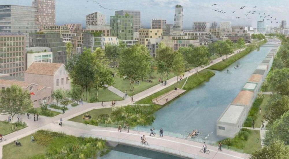
Utrecht to start construction on largest car-free neighborhood in the country next week
Construction of a new neighborhood is set to begin in Utrecht next week. The neighborhood, called Merwede, is scheduled to be the largest car-free district in the Netherlands, with 6,000 homes. The ar...
nltimes.nl
January 26, 2026 at 8:17 AM
In case you missed it, Utrecht, Netherlands has begun building the largest Dutch “car-free” neighbourhood.
12K people
6K homes
1.8K social rental homes
1.5 mid-range rental & affordable owner-occupied homes
21.5K bike parking spaces
250 shared cars
2 parcel hubs
Parking structures on the edge.
12K people
6K homes
1.8K social rental homes
1.5 mid-range rental & affordable owner-occupied homes
21.5K bike parking spaces
250 shared cars
2 parcel hubs
Parking structures on the edge.
Reposted by Jarrettinho
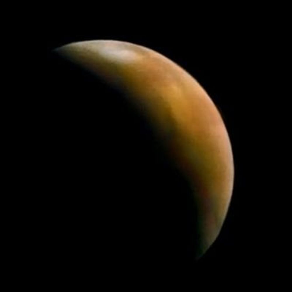
Today in 1986, Voyager 2 made humanity's first and only encounter with Uranus, revealing its clouds, rings, and fascinating zoo of moons.


January 24, 2026 at 5:18 PM
Today in 1986, Voyager 2 made humanity's first and only encounter with Uranus, revealing its clouds, rings, and fascinating zoo of moons.
Reposted by Jarrettinho

Thank you to the volunteers who have responded so quickly to the latest pollution event at Rye Harbour Nature Reserve.
We collected 40 bags of insulating foam pieces from the shipping containers + we also removed 20kg of onions & other produce.
📸 Matt Rich, Dave King, Arthur Sloman and Aimi Rifat
We collected 40 bags of insulating foam pieces from the shipping containers + we also removed 20kg of onions & other produce.
📸 Matt Rich, Dave King, Arthur Sloman and Aimi Rifat


January 25, 2026 at 10:01 AM
Thank you to the volunteers who have responded so quickly to the latest pollution event at Rye Harbour Nature Reserve.
We collected 40 bags of insulating foam pieces from the shipping containers + we also removed 20kg of onions & other produce.
📸 Matt Rich, Dave King, Arthur Sloman and Aimi Rifat
We collected 40 bags of insulating foam pieces from the shipping containers + we also removed 20kg of onions & other produce.
📸 Matt Rich, Dave King, Arthur Sloman and Aimi Rifat
Good point. Overland flows need more consideration in flood effects
Appropriately intercepting ‘Peak Overland Hydrological Flows’ with Nature based solutions, supported within farming schemes, will play a significant role in landscape scale climate change mitigation & adaptation. Delivering wider ecological community restoration & greater climate resilience ⬇️


January 23, 2026 at 8:57 AM
Good point. Overland flows need more consideration in flood effects
Reposted by Jarrettinho
I wanted dinner recommendations so I scraped 13,000+ London restaurants and accidentally discovered Google Maps is running a shadow economy. Anyway here's a dashboard and a political economy thesis: open.substack.com/pub/laurenle...

How Google Maps quietly allocates survival across London’s restaurants - and how I built a dashboard to see through it
I wanted a dinner recommendation and got a research agenda instead. Using 13000+ restaurants, I rebuild its ratings with machine learning and map how algorithmic visibility actually distributes power.
open.substack.com
December 9, 2025 at 7:53 AM
I wanted dinner recommendations so I scraped 13,000+ London restaurants and accidentally discovered Google Maps is running a shadow economy. Anyway here's a dashboard and a political economy thesis: open.substack.com/pub/laurenle...
Great article this
Why there’s no European Google?
And why it is a good thing!
My answer to the European Commission "call for evidence on Open Source."
https://ploum.net/2026-01-22-why-no-european-google.html
#geminiprotocol link: gemini://ploum.net/2026-01-22-why-no-european-google.gmi
And why it is a good thing!
My answer to the European Commission "call for evidence on Open Source."
https://ploum.net/2026-01-22-why-no-european-google.html
#geminiprotocol link: gemini://ploum.net/2026-01-22-why-no-european-google.gmi

Why there’s no European Google?
Why there’s no European Google? par Ploum - Lionel Dricot.
ploum.net
January 23, 2026 at 7:53 AM
Great article this
Reposted by Jarrettinho

What happens to Christmas trees after January? In Lancaster, they’re being reused as natural sea defences, slowing erosion and trapping sediment.Low-tech. Low-carbon. Clever.
goinggreenpodcast.blogspot.com/2026/01/what...
#SustainableInfrastructure #NatureBasedSolutions #CircularEconomy
goinggreenpodcast.blogspot.com/2026/01/what...
#SustainableInfrastructure #NatureBasedSolutions #CircularEconomy

January 12, 2026 at 9:14 AM
What happens to Christmas trees after January? In Lancaster, they’re being reused as natural sea defences, slowing erosion and trapping sediment.Low-tech. Low-carbon. Clever.
goinggreenpodcast.blogspot.com/2026/01/what...
#SustainableInfrastructure #NatureBasedSolutions #CircularEconomy
goinggreenpodcast.blogspot.com/2026/01/what...
#SustainableInfrastructure #NatureBasedSolutions #CircularEconomy
Reposted by Jarrettinho

Our Moor Resilience 2030 work is underpinned by evidence-led upland #peatland conservation works. Our Science and Monitoring team have set aspiring objectives to advance our peatland restoration knowledge base.
Read about our #science objectives on Substack:
substack.com/home/post/p-...
#peat
Read about our #science objectives on Substack:
substack.com/home/post/p-...
#peat

January 22, 2026 at 8:50 AM
Our Moor Resilience 2030 work is underpinned by evidence-led upland #peatland conservation works. Our Science and Monitoring team have set aspiring objectives to advance our peatland restoration knowledge base.
Read about our #science objectives on Substack:
substack.com/home/post/p-...
#peat
Read about our #science objectives on Substack:
substack.com/home/post/p-...
#peat
Reposted by Jarrettinho
How about that view? The Adur Valley from the Bostal, as spotted by Ranger Sarah Quantrill

January 17, 2026 at 9:30 AM
How about that view? The Adur Valley from the Bostal, as spotted by Ranger Sarah Quantrill
Reposted by Jarrettinho

Morning Sun - Edward Hopper, 1952.
Source : Musée d'Art de Columbus
Source : Musée d'Art de Columbus

January 17, 2026 at 7:49 AM
Morning Sun - Edward Hopper, 1952.
Source : Musée d'Art de Columbus
Source : Musée d'Art de Columbus
I've been experimenting with my own colour ramp to shade a DTM in #qgis to represent lowland terrain with a hillshade blending through.
I'm using #Qgis2threejs which is better than 3D view imo
Think the colour use is ok, but still not happy with how the hillshade comes through
#gischat
I'm using #Qgis2threejs which is better than 3D view imo
Think the colour use is ok, but still not happy with how the hillshade comes through
#gischat

January 16, 2026 at 2:28 PM
I've been experimenting with my own colour ramp to shade a DTM in #qgis to represent lowland terrain with a hillshade blending through.
I'm using #Qgis2threejs which is better than 3D view imo
Think the colour use is ok, but still not happy with how the hillshade comes through
#gischat
I'm using #Qgis2threejs which is better than 3D view imo
Think the colour use is ok, but still not happy with how the hillshade comes through
#gischat
Reposted by Jarrettinho
Technically the threshold for "bomb cyclogenesis" of an Atlantic storm is a 21mb drop over a 24 hour period, at our latitude of 50°N.
The pressure here has dropped 24 mb in 11 hours, from 730am. And it's still going down.
#StormGoretti
The pressure here has dropped 24 mb in 11 hours, from 730am. And it's still going down.
#StormGoretti
January 8, 2026 at 6:37 PM
Technically the threshold for "bomb cyclogenesis" of an Atlantic storm is a 21mb drop over a 24 hour period, at our latitude of 50°N.
The pressure here has dropped 24 mb in 11 hours, from 730am. And it's still going down.
#StormGoretti
The pressure here has dropped 24 mb in 11 hours, from 730am. And it's still going down.
#StormGoretti
I'm looking for some valued insight into #orfeotoolbox in #qgis I generally use the semi-automatic classification plugin for optical imagery and pre-process #sar using ESA snap. Is otb any better than what I'm using?
#gischat #remotesensing
#gischat #remotesensing
January 8, 2026 at 10:09 AM
I'm looking for some valued insight into #orfeotoolbox in #qgis I generally use the semi-automatic classification plugin for optical imagery and pre-process #sar using ESA snap. Is otb any better than what I'm using?
#gischat #remotesensing
#gischat #remotesensing
Reposted by Jarrettinho
A part of northern Germany and the Elbe Delta, covered with snow!
It's winter!
📸🛰#Sentinel2 2026.01.03
Footage: @sentinelonline.bsky.social
It's winter!
📸🛰#Sentinel2 2026.01.03
Footage: @sentinelonline.bsky.social

January 4, 2026 at 1:29 AM
A part of northern Germany and the Elbe Delta, covered with snow!
It's winter!
📸🛰#Sentinel2 2026.01.03
Footage: @sentinelonline.bsky.social
It's winter!
📸🛰#Sentinel2 2026.01.03
Footage: @sentinelonline.bsky.social

January 3, 2026 at 11:46 AM
Saw the fantastic #insideno9 stage show at the Hammersmith Apollo last night. Is it the last time we see them working together? By the amount of times they started laughing I doubt it

January 3, 2026 at 11:45 AM
Saw the fantastic #insideno9 stage show at the Hammersmith Apollo last night. Is it the last time we see them working together? By the amount of times they started laughing I doubt it


Reposted by Jarrettinho

£490k peatlands restoration to proceed in Falkirk and North Lanarkshire
->Envirotec Magazine | #peatland #restoration | More from Lil Dr Glen EcoChat at BigEarthData.ai
->Envirotec Magazine | #peatland #restoration | More from Lil Dr Glen EcoChat at BigEarthData.ai

£490k peatlands restoration to proceed in Falkirk and North Lanarkshire
SP Energy Networks has committed £490,000 to a major peatland restoration project on Scotland’s Slamannan Plateau. Working with Buglife Scotland, the initiative aims to bring over 114 hectares of rare bog habitat back to life across Falkirk and North Lanarkshire...
envirotecmagazine.com
December 18, 2025 at 1:42 PM
Reposted by Jarrettinho

Announcing the development of the Semi-Automatic Classification Plugin version 9
It will be released in early 2026.
https://fromgistors.blogspot.com/2025/12/development-of-scp-9.html
It will be released in early 2026.
https://fromgistors.blogspot.com/2025/12/development-of-scp-9.html

Announcing the development of the Semi-Automatic Classification Plugin version 9
I'm glad to announce that the **Semi-Automatic Classification Plugin version 9** (codename "Foundation") is under development.
It will be released in **early 2026** , in time for the release of QGIS 4, which will be based on Qt 6 framework. Therefore, the Semi-Automatic Classification Plugin version 9 will be ported to run on Qt 6 versions of QGIS.
In addition, there will be several new features, in particular:
* new classification algorithms, in particular the introduction of foundation models (hence the plugin codename "Foundation");
* a new simplified interface, in addition to the traditional user interface, designed for new users in order to focus on the classification process;
* new process that should ease the installation of the required dependency "Remotior Sensus".
The development of the Semi-Automatic Classification Plugin version 9 is running in parallel with the development of the Python library "Remotior Sensus", which will be updated to version 0.6, and include several performance enhancements, in addition to the foundation models. Foundation models are a particular type of machine learning models trained on huge amounts of satellite data, which can be adapted to several classification purposes.
This will be the first attempt to integrate deep learning foundation models into the Semi-Automatic Classification Plugin, in particular by using training data on features extracted by the model, thereby easing the processes required for running a pretrained model.
For any comment or question, join the Facebook group or GitHub discussions about the Semi-Automatic Classification Plugin.
fromgistors.blogspot.com
December 26, 2025 at 5:32 PM
Announcing the development of the Semi-Automatic Classification Plugin version 9
It will be released in early 2026.
https://fromgistors.blogspot.com/2025/12/development-of-scp-9.html
It will be released in early 2026.
https://fromgistors.blogspot.com/2025/12/development-of-scp-9.html
Reposted by Jarrettinho

Absolutely shocking.
We're offering an overall award of £10k for information that leads to a conviction in these cases.
We need to make raptor persecution a thing of the past.
We're offering an overall award of £10k for information that leads to a conviction in these cases.
We need to make raptor persecution a thing of the past.


December 17, 2025 at 2:18 PM
Absolutely shocking.
We're offering an overall award of £10k for information that leads to a conviction in these cases.
We need to make raptor persecution a thing of the past.
We're offering an overall award of £10k for information that leads to a conviction in these cases.
We need to make raptor persecution a thing of the past.
Today is #WorldSoilDay
Here's an animation of how #Sentinel1 satellite data can be used to delineate #peatland condition.
Turquoise denotes wetter peatland, drier areas are in brown.
Check out our research www.mdpi.com/2072-4292/17...
All with the power of #qgis
Here's an animation of how #Sentinel1 satellite data can be used to delineate #peatland condition.
Turquoise denotes wetter peatland, drier areas are in brown.
Check out our research www.mdpi.com/2072-4292/17...
All with the power of #qgis
December 5, 2025 at 8:41 AM
Today is #WorldSoilDay
Here's an animation of how #Sentinel1 satellite data can be used to delineate #peatland condition.
Turquoise denotes wetter peatland, drier areas are in brown.
Check out our research www.mdpi.com/2072-4292/17...
All with the power of #qgis
Here's an animation of how #Sentinel1 satellite data can be used to delineate #peatland condition.
Turquoise denotes wetter peatland, drier areas are in brown.
Check out our research www.mdpi.com/2072-4292/17...
All with the power of #qgis
Reposted by Jarrettinho
What an amazing way to visualize early human migration. Lovely map by @HarvardCGA. A great colour scheme and an appropriate map projection! Source: buff.ly/3lbxonJ

November 30, 2025 at 10:49 PM
What an amazing way to visualize early human migration. Lovely map by @HarvardCGA. A great colour scheme and an appropriate map projection! Source: buff.ly/3lbxonJ
