


Jarrettinho
@jarrettinho.bsky.social
Geoinformatics Consultant (Nature-based Solutions & Economic Development), QGIS, Charlton Athletic fan, European
On a walk today looking south to Plumpton Cross, the site of the Battle of Lewes. Also saw Stick Man! You get all sorts in the #southdowns


November 23, 2025 at 5:52 PM
On a walk today looking south to Plumpton Cross, the site of the Battle of Lewes. Also saw Stick Man! You get all sorts in the #southdowns
I had the honour of meeting Mani in Cologne in 1995. He was so keen to meet everyone who had come over to see them, wanting to know all our names and where we were from.
#ripmani life was never the same after hearing The Stone Roses for the first time - thank you
#ripmani life was never the same after hearing The Stone Roses for the first time - thank you

November 20, 2025 at 8:40 PM
I had the honour of meeting Mani in Cologne in 1995. He was so keen to meet everyone who had come over to see them, wanting to know all our names and where we were from.
#ripmani life was never the same after hearing The Stone Roses for the first time - thank you
#ripmani life was never the same after hearing The Stone Roses for the first time - thank you
Happy #GISDay2025!
Here's what #gis can support with what I'm involved with:
#remotesensing to delineate #peatland, monitor #naturalfloodmanagment
#Environmentalmonitoring for saltmarshes, landfield site waterway proximity
#Socioeconomic analysis on depopulation, young people in coastal towns
Here's what #gis can support with what I'm involved with:
#remotesensing to delineate #peatland, monitor #naturalfloodmanagment
#Environmentalmonitoring for saltmarshes, landfield site waterway proximity
#Socioeconomic analysis on depopulation, young people in coastal towns

November 19, 2025 at 7:12 PM
Happy #GISDay2025!
Here's what #gis can support with what I'm involved with:
#remotesensing to delineate #peatland, monitor #naturalfloodmanagment
#Environmentalmonitoring for saltmarshes, landfield site waterway proximity
#Socioeconomic analysis on depopulation, young people in coastal towns
Here's what #gis can support with what I'm involved with:
#remotesensing to delineate #peatland, monitor #naturalfloodmanagment
#Environmentalmonitoring for saltmarshes, landfield site waterway proximity
#Socioeconomic analysis on depopulation, young people in coastal towns
Day15 #30daymapchallenge Fire
My map uses #Sentinel1 images before/after the 2018 Lancashire #wildfire in the UK.
The dashed line shows the fire extent, which burned dry #peatland.
The colour range blue to yellow symbolises how radar represents wetter surfaces through to impermeable land cover.
My map uses #Sentinel1 images before/after the 2018 Lancashire #wildfire in the UK.
The dashed line shows the fire extent, which burned dry #peatland.
The colour range blue to yellow symbolises how radar represents wetter surfaces through to impermeable land cover.
November 15, 2025 at 9:11 AM
Day15 #30daymapchallenge Fire
My map uses #Sentinel1 images before/after the 2018 Lancashire #wildfire in the UK.
The dashed line shows the fire extent, which burned dry #peatland.
The colour range blue to yellow symbolises how radar represents wetter surfaces through to impermeable land cover.
My map uses #Sentinel1 images before/after the 2018 Lancashire #wildfire in the UK.
The dashed line shows the fire extent, which burned dry #peatland.
The colour range blue to yellow symbolises how radar represents wetter surfaces through to impermeable land cover.
These images were only 23 days apart in winter 2022/23 in the West Pennine Moors, but demonstrate #Sentinel1 radar differences due to temperature. Our research found S1 images in frozen conditions could better delineate peatland & show differences in wetness.
Check it www.mdpi.com/2072-4292/17...
Check it www.mdpi.com/2072-4292/17...

November 13, 2025 at 11:30 AM
These images were only 23 days apart in winter 2022/23 in the West Pennine Moors, but demonstrate #Sentinel1 radar differences due to temperature. Our research found S1 images in frozen conditions could better delineate peatland & show differences in wetness.
Check it www.mdpi.com/2072-4292/17...
Check it www.mdpi.com/2072-4292/17...
This Is The One!
Day 1 of #30daymapchallenge is points.
I've drawn my inspiration from 1989 and the rise of the #StoneRoses using the iconic lemon synonymous with their artwork to symbolise venue capacities.
Had a lot of fun making this.
All with the power of #qgis
#gis #maps #cartography
Day 1 of #30daymapchallenge is points.
I've drawn my inspiration from 1989 and the rise of the #StoneRoses using the iconic lemon synonymous with their artwork to symbolise venue capacities.
Had a lot of fun making this.
All with the power of #qgis
#gis #maps #cartography

November 1, 2025 at 11:37 AM
This Is The One!
Day 1 of #30daymapchallenge is points.
I've drawn my inspiration from 1989 and the rise of the #StoneRoses using the iconic lemon synonymous with their artwork to symbolise venue capacities.
Had a lot of fun making this.
All with the power of #qgis
#gis #maps #cartography
Day 1 of #30daymapchallenge is points.
I've drawn my inspiration from 1989 and the rise of the #StoneRoses using the iconic lemon synonymous with their artwork to symbolise venue capacities.
Had a lot of fun making this.
All with the power of #qgis
#gis #maps #cartography
Great day on the #southdownsway in #sussex
Saw a kestrel, loads of skylarks & a little egret on the #riveradur
Saw a kestrel, loads of skylarks & a little egret on the #riveradur


October 25, 2025 at 4:48 PM
Great day on the #southdownsway in #sussex
Saw a kestrel, loads of skylarks & a little egret on the #riveradur
Saw a kestrel, loads of skylarks & a little egret on the #riveradur

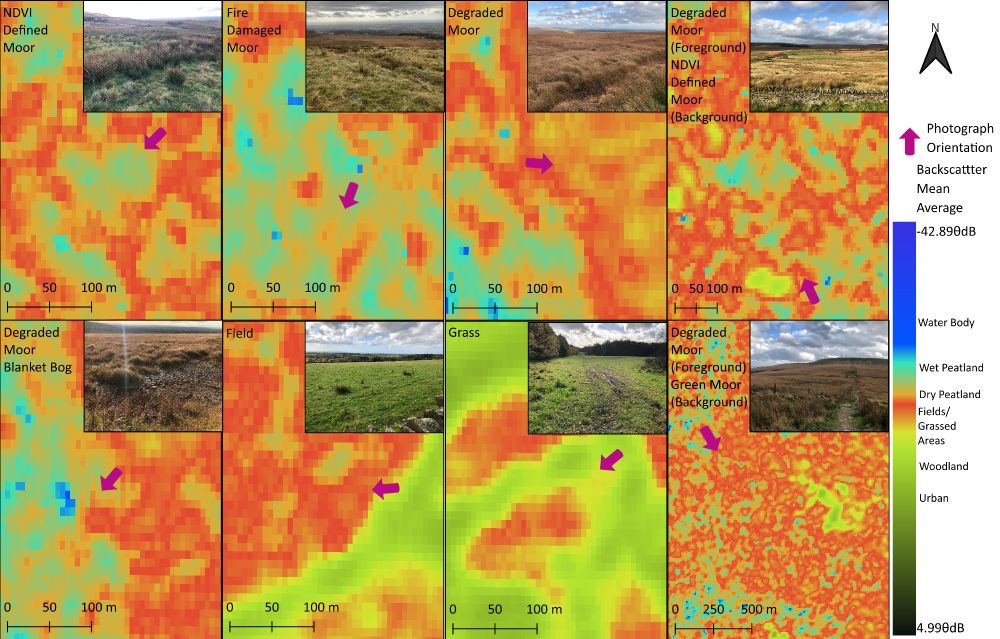
Interesting visuals of #wildfire damage mapped with #remotesensing when for a project on the potential of #Sentinel1 in delineating #peatland.
The lined area shows the effects of the 2018 Winter Hill wildfire in Lancashire & #restoration works since.
Check out our research lnkd.in/eaPpipQu
#qgis
The lined area shows the effects of the 2018 Winter Hill wildfire in Lancashire & #restoration works since.
Check out our research lnkd.in/eaPpipQu
#qgis
October 23, 2025 at 1:18 PM
Interesting visuals of #wildfire damage mapped with #remotesensing when for a project on the potential of #Sentinel1 in delineating #peatland.
The lined area shows the effects of the 2018 Winter Hill wildfire in Lancashire & #restoration works since.
Check out our research lnkd.in/eaPpipQu
#qgis
The lined area shows the effects of the 2018 Winter Hill wildfire in Lancashire & #restoration works since.
Check out our research lnkd.in/eaPpipQu
#qgis
The #geography of cash compared with mortgage house purchases in the UK (no data for NI) in 2024.
There's a definite predominance of tourism areas where cash purchases are greater than with mortgages, with a feint north/south divide overall.
#gis #qgis #mapping
There's a definite predominance of tourism areas where cash purchases are greater than with mortgages, with a feint north/south divide overall.
#gis #qgis #mapping

October 17, 2025 at 6:34 AM
The #geography of cash compared with mortgage house purchases in the UK (no data for NI) in 2024.
There's a definite predominance of tourism areas where cash purchases are greater than with mortgages, with a feint north/south divide overall.
#gis #qgis #mapping
There's a definite predominance of tourism areas where cash purchases are greater than with mortgages, with a feint north/south divide overall.
#gis #qgis #mapping
With our #publicservices under ever more strain, it's important to highlight why places such as Leeds Central Library are essential parts of our social fabric

October 3, 2025 at 11:41 AM
With our #publicservices under ever more strain, it's important to highlight why places such as Leeds Central Library are essential parts of our social fabric
My first time at the @uk.osgeo.org conference. It inspired me to highlight my research applying #Sentinel1 to #peatland with #qgis was published in the @mdpiopenaccess.bsky.social Remote Sensing journal lnkd.in/eaPpipQu
With zero funding resources, it was possible because of #foss4g resources.
#gis
With zero funding resources, it was possible because of #foss4g resources.
#gis
October 3, 2025 at 10:14 AM
My first time at the @uk.osgeo.org conference. It inspired me to highlight my research applying #Sentinel1 to #peatland with #qgis was published in the @mdpiopenaccess.bsky.social Remote Sensing journal lnkd.in/eaPpipQu
With zero funding resources, it was possible because of #foss4g resources.
#gis
With zero funding resources, it was possible because of #foss4g resources.
#gis
Looking forward to my first @uk.osgeo.org #FOSS4GUK conference today in #Leeds. Will be great to meet new #geospatial people 5 undoubtedly learn more about #qgis & other #opensource #gis tools

October 1, 2025 at 8:26 AM
Looking forward to my first @uk.osgeo.org #FOSS4GUK conference today in #Leeds. Will be great to meet new #geospatial people 5 undoubtedly learn more about #qgis & other #opensource #gis tools
Read an article on the pollution potential of waste sites, which got me thinking about the power of #GIS & #opendata.
By intersecting historic landfill site locations & the network of rivers in England/Wales, nearly 6,000 locations were identified where these sites are within 100m of a water course
By intersecting historic landfill site locations & the network of rivers in England/Wales, nearly 6,000 locations were identified where these sites are within 100m of a water course

September 26, 2025 at 3:51 PM
After 18 months of research with Dr Daniel Hölbling @zgis.bsky.social, our work on #Sentinel1 #sar to delineate #peatland has been published.
www.mdpi.com/2072-4292/17...
We have plenty more ideas to support #naturebasedsolutions. Check out our previous research www.mdpi.com/2335050
Get in touch.
www.mdpi.com/2072-4292/17...
We have plenty more ideas to support #naturebasedsolutions. Check out our previous research www.mdpi.com/2335050
Get in touch.

September 11, 2025 at 9:21 AM
After 18 months of research with Dr Daniel Hölbling @zgis.bsky.social, our work on #Sentinel1 #sar to delineate #peatland has been published.
www.mdpi.com/2072-4292/17...
We have plenty more ideas to support #naturebasedsolutions. Check out our previous research www.mdpi.com/2335050
Get in touch.
www.mdpi.com/2072-4292/17...
We have plenty more ideas to support #naturebasedsolutions. Check out our previous research www.mdpi.com/2335050
Get in touch.

July 30, 2025 at 12:48 PM
Great piece on rewetting landscapes in @theconversation.com at the Smithills Estate, Bolton UK
theconversation.com/how-restorin...
My research looks at this area using #Sentinel1 #remotesensing to delineate #peatland & assess relative condition.
#qgis #nfm #nbs
theconversation.com/how-restorin...
My research looks at this area using #Sentinel1 #remotesensing to delineate #peatland & assess relative condition.
#qgis #nfm #nbs

June 26, 2025 at 9:02 AM
Great piece on rewetting landscapes in @theconversation.com at the Smithills Estate, Bolton UK
theconversation.com/how-restorin...
My research looks at this area using #Sentinel1 #remotesensing to delineate #peatland & assess relative condition.
#qgis #nfm #nbs
theconversation.com/how-restorin...
My research looks at this area using #Sentinel1 #remotesensing to delineate #peatland & assess relative condition.
#qgis #nfm #nbs


For over a year I’ve been applying #Sentinel1 #sar to #peatland after finding strange data in the West Pennines due to a huge wildfire that occurred in 2018.
A paper is imminent that presents results from S1, as compared with the new English Peat #Map below. Unfunded but vital imo.
lnkd.in/eBVWhDzm
A paper is imminent that presents results from S1, as compared with the new English Peat #Map below. Unfunded but vital imo.
lnkd.in/eBVWhDzm

May 16, 2025 at 8:51 AM
For over a year I’ve been applying #Sentinel1 #sar to #peatland after finding strange data in the West Pennines due to a huge wildfire that occurred in 2018.
A paper is imminent that presents results from S1, as compared with the new English Peat #Map below. Unfunded but vital imo.
lnkd.in/eBVWhDzm
A paper is imminent that presents results from S1, as compared with the new English Peat #Map below. Unfunded but vital imo.
lnkd.in/eBVWhDzm
It's the #LocalElection for some in the UK today, so here's a map of turnout at the 2024 General Election
#gis #cartography #opendata #qgis
#gis #cartography #opendata #qgis

May 1, 2025 at 1:19 PM
It's the #LocalElection for some in the UK today, so here's a map of turnout at the 2024 General Election
#gis #cartography #opendata #qgis
#gis #cartography #opendata #qgis

#gis shout out!
Is there a way in #qgis of being able to create a #bivariate legend for a 2-band #raster layer in print composer?
There is the polygonise route to create choropleths & the bivariate plugin, but wanted to know if there is a way using original raster data
#gischat #cartography
Is there a way in #qgis of being able to create a #bivariate legend for a 2-band #raster layer in print composer?
There is the polygonise route to create choropleths & the bivariate plugin, but wanted to know if there is a way using original raster data
#gischat #cartography

April 25, 2025 at 10:07 AM
#gis shout out!
Is there a way in #qgis of being able to create a #bivariate legend for a 2-band #raster layer in print composer?
There is the polygonise route to create choropleths & the bivariate plugin, but wanted to know if there is a way using original raster data
#gischat #cartography
Is there a way in #qgis of being able to create a #bivariate legend for a 2-band #raster layer in print composer?
There is the polygonise route to create choropleths & the bivariate plugin, but wanted to know if there is a way using original raster data
#gischat #cartography

Pleased to see my research with Daniel Hölbling used as part of the Environment Agency's Working With Nature report on the benefits of #naturalfloodmanagement.
#gis #sentinel1 #remotesensing can play a part in monitoring
www.gov.uk/government/n...
#gis #sentinel1 #remotesensing can play a part in monitoring
www.gov.uk/government/n...

March 30, 2025 at 6:15 PM
Pleased to see my research with Daniel Hölbling used as part of the Environment Agency's Working With Nature report on the benefits of #naturalfloodmanagement.
#gis #sentinel1 #remotesensing can play a part in monitoring
www.gov.uk/government/n...
#gis #sentinel1 #remotesensing can play a part in monitoring
www.gov.uk/government/n...