


Robert Simmon
@rsimmon.bsky.social
Data Visualization. Ex-Planet & NASA Earth Observatory. Blue Marble, Earth at Night, color, cartography, occasionally skewed views of Earth. Looking for a job.
Reposted by Robert Simmon
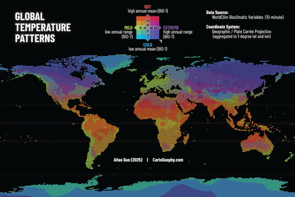
#30DayMapChallenge | Day 10 Air | This is an exploratory bivariate map illustrating global temperature patterns based on WorldClim bioclimatic variables: annual mean temperature (BIO-1) and annual temperature range (BIO-7). Read more: cartoguophy.com/maps/global_...
November 10, 2025 at 3:42 PM
#30DayMapChallenge | Day 10 Air | This is an exploratory bivariate map illustrating global temperature patterns based on WorldClim bioclimatic variables: annual mean temperature (BIO-1) and annual temperature range (BIO-7). Read more: cartoguophy.com/maps/global_...
📊🗺️👀

The Australian Inland Mission's stunning cartographic work between 1922 and 1970. Link: attilabatorfy.substack.com/p/helping-th...


November 10, 2025 at 4:54 PM
📊🗺️👀
The Planet satellite image I made for the Autódromo José Carlos Pace (Interlagos) is still being used by Wikipedia!
en.wikipedia.org/wiki/Interla...
en.wikipedia.org/wiki/Interla...

November 9, 2025 at 9:52 PM
The Planet satellite image I made for the Autódromo José Carlos Pace (Interlagos) is still being used by Wikipedia!
en.wikipedia.org/wiki/Interla...
en.wikipedia.org/wiki/Interla...
Reposted by Robert Simmon

This same area had another sequence that started in 11/2002 that continued into 2/2003. That sequence included a bunch of M3+ events and a few M4’s just to the southeast (not included on this list below).
Data from ds.iris.edu/ieb/index.ht...
Data from ds.iris.edu/ieb/index.ht...

November 9, 2025 at 6:45 PM
This same area had another sequence that started in 11/2002 that continued into 2/2003. That sequence included a bunch of M3+ events and a few M4’s just to the southeast (not included on this list below).
Data from ds.iris.edu/ieb/index.ht...
Data from ds.iris.edu/ieb/index.ht...

Reposted by Robert Simmon

We at Esri look forward to seeing you at #AGU25, showcasing with our products & services not only how geospatial enables greater understanding of the world, but how we also perform good science as a member of the scientific community.
www.esri.com/arcgis-blog/...
🧪 🦑 🌊 🌎 🌍 🌏 ⚒️ #geogsky #geogchat
www.esri.com/arcgis-blog/...
🧪 🦑 🌊 🌎 🌍 🌏 ⚒️ #geogsky #geogchat

November 8, 2025 at 12:21 AM
We at Esri look forward to seeing you at #AGU25, showcasing with our products & services not only how geospatial enables greater understanding of the world, but how we also perform good science as a member of the scientific community.
www.esri.com/arcgis-blog/...
🧪 🦑 🌊 🌎 🌍 🌏 ⚒️ #geogsky #geogchat
www.esri.com/arcgis-blog/...
🧪 🦑 🌊 🌎 🌍 🌏 ⚒️ #geogsky #geogchat

TIL (via @mapsbyw.com ): @jscarto.bsky.social made a global basemap with NASA data: visibleearth.nasa.gov/images/14719...

November 7, 2025 at 6:33 PM
TIL (via @mapsbyw.com ): @jscarto.bsky.social made a global basemap with NASA data: visibleearth.nasa.gov/images/14719...
I just had to resolve a minor issue with the IRS, and the agent I worked with was fantastic, even during the shutdown!
November 7, 2025 at 6:15 PM
I just had to resolve a minor issue with the IRS, and the agent I worked with was fantastic, even during the shutdown!
Thoughts from Aravind Ravichandran as NASA (again) flirts with moving Earth observation to commercial data buys:
“Here is an underappreciated irony: commercial EO companies already depend on NASA's public infrastructure.”
newsletter.terrawatchspace.com/why-science-...
“Here is an underappreciated irony: commercial EO companies already depend on NASA's public infrastructure.”
newsletter.terrawatchspace.com/why-science-...

Why "Science-as-a-Service" Doesn't Work for Earth Science
There has been a lot of talk lately about whether commercial Earth observation (EO) companies could replace parts of NASA’s Earth science mission portfolio. With a new Administrator coming in, that de...
newsletter.terrawatchspace.com
November 7, 2025 at 5:43 PM
Thoughts from Aravind Ravichandran as NASA (again) flirts with moving Earth observation to commercial data buys:
“Here is an underappreciated irony: commercial EO companies already depend on NASA's public infrastructure.”
newsletter.terrawatchspace.com/why-science-...
“Here is an underappreciated irony: commercial EO companies already depend on NASA's public infrastructure.”
newsletter.terrawatchspace.com/why-science-...
Reposted by Robert Simmon

#30DayMapChallenge 7 Nov - Accessibility
This map shows the weather stations operated by the Spanish Met Service and regions where there is a lack of stations.
𝗧𝗵𝗲 𝗹𝗮𝗰𝗸 𝗼𝗳 𝘄𝗲𝗮𝘁𝗵𝗲𝗿 𝘀𝘁𝗮𝘁𝗶𝗼𝗻 𝗰𝗼𝘃𝗲𝗿𝗮𝗴𝗲 𝗹𝗶𝗺𝗶𝘁𝘀 𝘁𝗵𝗲 𝗮𝗯𝗶𝗹𝗶𝘁𝘆 𝘁𝗼 𝗱𝗲𝘁𝗲𝗰𝘁 𝗮𝗻𝗱 𝗮𝗻𝘁𝗶𝗰𝗶𝗽𝗮𝘁𝗲 𝗲𝘅𝘁𝗿𝗲𝗺𝗲 𝗲𝘃𝗲𝗻𝘁𝘀.
#aemet #geopandas #cartopy
This map shows the weather stations operated by the Spanish Met Service and regions where there is a lack of stations.
𝗧𝗵𝗲 𝗹𝗮𝗰𝗸 𝗼𝗳 𝘄𝗲𝗮𝘁𝗵𝗲𝗿 𝘀𝘁𝗮𝘁𝗶𝗼𝗻 𝗰𝗼𝘃𝗲𝗿𝗮𝗴𝗲 𝗹𝗶𝗺𝗶𝘁𝘀 𝘁𝗵𝗲 𝗮𝗯𝗶𝗹𝗶𝘁𝘆 𝘁𝗼 𝗱𝗲𝘁𝗲𝗰𝘁 𝗮𝗻𝗱 𝗮𝗻𝘁𝗶𝗰𝗶𝗽𝗮𝘁𝗲 𝗲𝘅𝘁𝗿𝗲𝗺𝗲 𝗲𝘃𝗲𝗻𝘁𝘀.
#aemet #geopandas #cartopy

November 7, 2025 at 8:57 AM
#30DayMapChallenge 7 Nov - Accessibility
This map shows the weather stations operated by the Spanish Met Service and regions where there is a lack of stations.
𝗧𝗵𝗲 𝗹𝗮𝗰𝗸 𝗼𝗳 𝘄𝗲𝗮𝘁𝗵𝗲𝗿 𝘀𝘁𝗮𝘁𝗶𝗼𝗻 𝗰𝗼𝘃𝗲𝗿𝗮𝗴𝗲 𝗹𝗶𝗺𝗶𝘁𝘀 𝘁𝗵𝗲 𝗮𝗯𝗶𝗹𝗶𝘁𝘆 𝘁𝗼 𝗱𝗲𝘁𝗲𝗰𝘁 𝗮𝗻𝗱 𝗮𝗻𝘁𝗶𝗰𝗶𝗽𝗮𝘁𝗲 𝗲𝘅𝘁𝗿𝗲𝗺𝗲 𝗲𝘃𝗲𝗻𝘁𝘀.
#aemet #geopandas #cartopy
This map shows the weather stations operated by the Spanish Met Service and regions where there is a lack of stations.
𝗧𝗵𝗲 𝗹𝗮𝗰𝗸 𝗼𝗳 𝘄𝗲𝗮𝘁𝗵𝗲𝗿 𝘀𝘁𝗮𝘁𝗶𝗼𝗻 𝗰𝗼𝘃𝗲𝗿𝗮𝗴𝗲 𝗹𝗶𝗺𝗶𝘁𝘀 𝘁𝗵𝗲 𝗮𝗯𝗶𝗹𝗶𝘁𝘆 𝘁𝗼 𝗱𝗲𝘁𝗲𝗰𝘁 𝗮𝗻𝗱 𝗮𝗻𝘁𝗶𝗰𝗶𝗽𝗮𝘁𝗲 𝗲𝘅𝘁𝗿𝗲𝗺𝗲 𝗲𝘃𝗲𝗻𝘁𝘀.
#aemet #geopandas #cartopy
Reposted by Robert Simmon

"It represents a substantial 59% increase over the previous mapping of 188,555 kilometres of Roman roads. This is a very significant expansion of our mapped knowledge of ancient infrastructure."
#History #Maps #Roads #Roman
#History #Maps #Roads #Roman

The Roman empire built 300,000 kilometres of roads: new study
A new comprehensive map reveals the true scale of the ancient Roman road network – but it is still incomplete.
theconversation.com
November 7, 2025 at 12:32 PM
Reposted by Robert Simmon

Computation+Journalism 2025 is a month away (December 11-12); we're finishing the last details of the symposium: cplusj2025.com Here's the full agenda: cplusj2025.com/agenda/ Join us! You can register here ($150 for professionals, $30 for students): events.miami.edu/event/cplusj...

November 6, 2025 at 4:24 PM
Computation+Journalism 2025 is a month away (December 11-12); we're finishing the last details of the symposium: cplusj2025.com Here's the full agenda: cplusj2025.com/agenda/ Join us! You can register here ($150 for professionals, $30 for students): events.miami.edu/event/cplusj...
Reposted by Robert Simmon

✅ edits from print proof
MAPS FOR KIDS coming soon.
MAPS FOR KIDS coming soon.

November 5, 2025 at 8:09 PM
✅ edits from print proof
MAPS FOR KIDS coming soon.
MAPS FOR KIDS coming soon.
Somehow I missed this BlackSky satellite image of Petra (as seen in Indiana Jones and the Last Crusade). From www.linkedin.com/feed/update/...

November 5, 2025 at 7:14 PM
Somehow I missed this BlackSky satellite image of Petra (as seen in Indiana Jones and the Last Crusade). From www.linkedin.com/feed/update/...
Reposted by Robert Simmon
Volunteers Needed! Will you be at #AGU25? Consider leading a small group tour of the exhibit hall, focused on a theme or topic of your choice. These are science-focused discussions (no marketing!), with each tour ~30-60 min.
Learn more & sign up by tomorrow:
docs.google.com/forms/d/e/1F...
Learn more & sign up by tomorrow:
docs.google.com/forms/d/e/1F...

Volunteer Sign-Up: AGU 2025 Distributed Sensing Exhibit Hall Tours
Thank you for your interest in helping lead and organize guided tours of the AGU 2025 Exhibit Hall!
These tours will highlight emerging distributed sensing technologies across Earth and space science...
docs.google.com
November 5, 2025 at 5:30 PM
Volunteers Needed! Will you be at #AGU25? Consider leading a small group tour of the exhibit hall, focused on a theme or topic of your choice. These are science-focused discussions (no marketing!), with each tour ~30-60 min.
Learn more & sign up by tomorrow:
docs.google.com/forms/d/e/1F...
Learn more & sign up by tomorrow:
docs.google.com/forms/d/e/1F...
There’s an entire book by @kennethfield.bsky.social on ways to map elections: www.esri.com/en-us/esri-p...
🗺️
🗺️
November 5, 2025 at 6:53 PM
There’s an entire book by @kennethfield.bsky.social on ways to map elections: www.esri.com/en-us/esri-p...
🗺️
🗺️
Reposted by Robert Simmon

Divide and concur — this radical plan from 1920, for "lasting peace" after WW1, proposed uniting central Europe into 24 wedge-shaped cantons which would radiate out from Vienna’s St. Stephen’s Cathedral: https://publicdomainreview.org/collection/unionization-of-central-europe/


November 5, 2025 at 3:15 PM
Divide and concur — this radical plan from 1920, for "lasting peace" after WW1, proposed uniting central Europe into 24 wedge-shaped cantons which would radiate out from Vienna’s St. Stephen’s Cathedral: https://publicdomainreview.org/collection/unionization-of-central-europe/


Reposted by Robert Simmon

These are now being generated from eBird checklists.
I need to sort out a bunch of things but they're fun for testing.
Colors of birds extracted from Wikipedia descriptions.
🪶
I need to sort out a bunch of things but they're fun for testing.
Colors of birds extracted from Wikipedia descriptions.
🪶


November 1, 2025 at 8:41 PM
These are now being generated from eBird checklists.
I need to sort out a bunch of things but they're fun for testing.
Colors of birds extracted from Wikipedia descriptions.
🪶
I need to sort out a bunch of things but they're fun for testing.
Colors of birds extracted from Wikipedia descriptions.
🪶
Reposted by Robert Simmon


Reposted by Robert Simmon

#30DayMapChallenge 🗺️ Day 2️⃣: Lines
This map shows all the airports with direct flights from #Singapore’s 🇸🇬 #ChangiAirport (#SIN) rendered on a custom logarithmic azimuthal map. Airports that are served by more airlines, like Jakarta (CGK) and Narita (NRT), are shown more prominently. 🧵 1/3
#avgeek
This map shows all the airports with direct flights from #Singapore’s 🇸🇬 #ChangiAirport (#SIN) rendered on a custom logarithmic azimuthal map. Airports that are served by more airlines, like Jakarta (CGK) and Narita (NRT), are shown more prominently. 🧵 1/3
#avgeek

November 2, 2025 at 12:05 PM
#30DayMapChallenge 🗺️ Day 2️⃣: Lines
This map shows all the airports with direct flights from #Singapore’s 🇸🇬 #ChangiAirport (#SIN) rendered on a custom logarithmic azimuthal map. Airports that are served by more airlines, like Jakarta (CGK) and Narita (NRT), are shown more prominently. 🧵 1/3
#avgeek
This map shows all the airports with direct flights from #Singapore’s 🇸🇬 #ChangiAirport (#SIN) rendered on a custom logarithmic azimuthal map. Airports that are served by more airlines, like Jakarta (CGK) and Narita (NRT), are shown more prominently. 🧵 1/3
#avgeek
Reposted by Robert Simmon

It's the second day of the #30DayMapChallenge!
Some friends of mine got a new place in Prospect Lefferts Gardens. Coming from Park Slope, the walk between each avenue seemed so much longer.
It is. I mapped block lengths to see how it shakes out throughout the city: jillhubley.com/project/bloc...
Some friends of mine got a new place in Prospect Lefferts Gardens. Coming from Park Slope, the walk between each avenue seemed so much longer.
It is. I mapped block lengths to see how it shakes out throughout the city: jillhubley.com/project/bloc...

November 2, 2025 at 1:22 PM
It's the second day of the #30DayMapChallenge!
Some friends of mine got a new place in Prospect Lefferts Gardens. Coming from Park Slope, the walk between each avenue seemed so much longer.
It is. I mapped block lengths to see how it shakes out throughout the city: jillhubley.com/project/bloc...
Some friends of mine got a new place in Prospect Lefferts Gardens. Coming from Park Slope, the walk between each avenue seemed so much longer.
It is. I mapped block lengths to see how it shakes out throughout the city: jillhubley.com/project/bloc...