


OpenTopography
@opentopography.org
Open access to high-resolution, Earth science-oriented topography data, and related tools & resources. US National Science Foundation supported. #lidar https://www.opentopography.org
Pinned
OpenTopography
@opentopography.org
· Mar 13

OpenTopography: Unveiling the Earth's Surface
YouTube video by OpenTopography
youtu.be
New short (3 minute) video answers the question "What is OpenTopography?":
For the last several decades, scientists have been developing a way to make our maps more reliable with point cloud data collected by lidar. Lidar is an accurate method that helps scientists to map cities, landscapes, and places that were previously difficult or dangerous to access.
November 10, 2025 at 5:26 PM
For the last several decades, scientists have been developing a way to make our maps more reliable with point cloud data collected by lidar. Lidar is an accurate method that helps scientists to map cities, landscapes, and places that were previously difficult or dangerous to access.
New for educators! Lab Exercise: Using lidar to track Lake Michigan bluff retreat and inform local communities
Designed for community college and intro-level geomorph, enviro sci, and GIS courses, students use lidar data to learn about dynamic coastal erosion.
opentopography.org/learn/WI_blu...
Designed for community college and intro-level geomorph, enviro sci, and GIS courses, students use lidar data to learn about dynamic coastal erosion.
opentopography.org/learn/WI_blu...

November 3, 2025 at 10:22 PM
New for educators! Lab Exercise: Using lidar to track Lake Michigan bluff retreat and inform local communities
Designed for community college and intro-level geomorph, enviro sci, and GIS courses, students use lidar data to learn about dynamic coastal erosion.
opentopography.org/learn/WI_blu...
Designed for community college and intro-level geomorph, enviro sci, and GIS courses, students use lidar data to learn about dynamic coastal erosion.
opentopography.org/learn/WI_blu...
Reposted by OpenTopography

Discover how #lidar reveals the size & location of individual Ponderosa Pines at Sunset Crater, AZ! Using advanced algorithms in lidR, we map tree height and crowns in stunning detail, informing forest ecology and management.
openforest4d.org/tree-identif...
#Forestry
#RemoteSensing
#RStats
openforest4d.org/tree-identif...
#Forestry
#RemoteSensing
#RStats

October 30, 2025 at 3:41 PM
Discover how #lidar reveals the size & location of individual Ponderosa Pines at Sunset Crater, AZ! Using advanced algorithms in lidR, we map tree height and crowns in stunning detail, informing forest ecology and management.
openforest4d.org/tree-identif...
#Forestry
#RemoteSensing
#RStats
openforest4d.org/tree-identif...
#Forestry
#RemoteSensing
#RStats
The new NSF-funded Center for Land Surface Hazards (CLaSH) at U. Michigan is seeking an Assistant Director to help lead an ambitious, interdisciplinary effort to transform the science of and advance community resilience for hazards like landslides and flooding:
careers.umich.edu/job_detail/2...
careers.umich.edu/job_detail/2...
Center Assistant Director | U-M Careers
careers.umich.edu
October 27, 2025 at 7:42 PM
The new NSF-funded Center for Land Surface Hazards (CLaSH) at U. Michigan is seeking an Assistant Director to help lead an ambitious, interdisciplinary effort to transform the science of and advance community resilience for hazards like landslides and flooding:
careers.umich.edu/job_detail/2...
careers.umich.edu/job_detail/2...
Reposted by OpenTopography
Ever wondered what #lidar point clouds reveal about forests? OpenForest4D’s new guide breaks down how elevation, return number, intensity, and classification describe forest structure.
openforest4d.org/lidar-point-...
#pointcloud #laserscanning #forestry #geospatial
openforest4d.org/lidar-point-...
#pointcloud #laserscanning #forestry #geospatial

October 27, 2025 at 4:33 PM
Ever wondered what #lidar point clouds reveal about forests? OpenForest4D’s new guide breaks down how elevation, return number, intensity, and classification describe forest structure.
openforest4d.org/lidar-point-...
#pointcloud #laserscanning #forestry #geospatial
openforest4d.org/lidar-point-...
#pointcloud #laserscanning #forestry #geospatial
Reposted by OpenTopography

Fan in the Fall River valley produced by the 1982 Lawn Lake Flood, caused by failure of an old dam in Rocky Mtn. NP. I was scanning photos of the bouldery fan taken by Jim Knox, and decided to try a 3D view with lidar data and #rayshader. 0.5 m DEM from USGS point cloud via @opentopography.org

October 19, 2025 at 2:00 AM
Fan in the Fall River valley produced by the 1982 Lawn Lake Flood, caused by failure of an old dam in Rocky Mtn. NP. I was scanning photos of the bouldery fan taken by Jim Knox, and decided to try a 3D view with lidar data and #rayshader. 0.5 m DEM from USGS point cloud via @opentopography.org
OT will be at GSA Connects 2025 in San Antonio, TX, Oct 19–22. Visit us at booth 809 to talk lidar, topography, and grab an "I ❤️ LIDAR" sticker. OT is honored to receive the 2025 GSA President’s Medal. Join us for the President’s Medal Lecture on Mon Oct. 20.
opentopography.org/news/opentop...
opentopography.org/news/opentop...

October 15, 2025 at 3:32 PM
OT will be at GSA Connects 2025 in San Antonio, TX, Oct 19–22. Visit us at booth 809 to talk lidar, topography, and grab an "I ❤️ LIDAR" sticker. OT is honored to receive the 2025 GSA President’s Medal. Join us for the President’s Medal Lecture on Mon Oct. 20.
opentopography.org/news/opentop...
opentopography.org/news/opentop...
OpenTopography services may be intermittently unavailable from 11 AM to 12 PM PDT on Tuesday, October 14, 2025 during system updates. Thank you for your patience.
October 10, 2025 at 5:19 PM
OpenTopography services may be intermittently unavailable from 11 AM to 12 PM PDT on Tuesday, October 14, 2025 during system updates. Thank you for your patience.
New September 2025 data releases on OpenTopography include Land Information New Zealand (LINZ) lidar over the North Island of New Zealand, SfM topography over the 2019 Ridgecrest rupture, NOAA coastal lidar additions, and additional USGS 3DEP data.
opentopography.org/news/septemb...
opentopography.org/news/septemb...


October 2, 2025 at 5:44 PM
New September 2025 data releases on OpenTopography include Land Information New Zealand (LINZ) lidar over the North Island of New Zealand, SfM topography over the 2019 Ridgecrest rupture, NOAA coastal lidar additions, and additional USGS 3DEP data.
opentopography.org/news/septemb...
opentopography.org/news/septemb...
Reposted by OpenTopography
🌲 Join us at ForestSAT 2026! 🌍
📅 May 4–8, 2026 | Hybrid – Attend in-person or online
📧 Questions? Reach out at ForestSAT2026@ifas.ufl.edu
Discover the benefits of attending: carlos-alberto-silva.github.io/silvalab/For...
📅 May 4–8, 2026 | Hybrid – Attend in-person or online
📧 Questions? Reach out at ForestSAT2026@ifas.ufl.edu
Discover the benefits of attending: carlos-alberto-silva.github.io/silvalab/For...


September 29, 2025 at 7:30 PM
🌲 Join us at ForestSAT 2026! 🌍
📅 May 4–8, 2026 | Hybrid – Attend in-person or online
📧 Questions? Reach out at ForestSAT2026@ifas.ufl.edu
Discover the benefits of attending: carlos-alberto-silva.github.io/silvalab/For...
📅 May 4–8, 2026 | Hybrid – Attend in-person or online
📧 Questions? Reach out at ForestSAT2026@ifas.ufl.edu
Discover the benefits of attending: carlos-alberto-silva.github.io/silvalab/For...
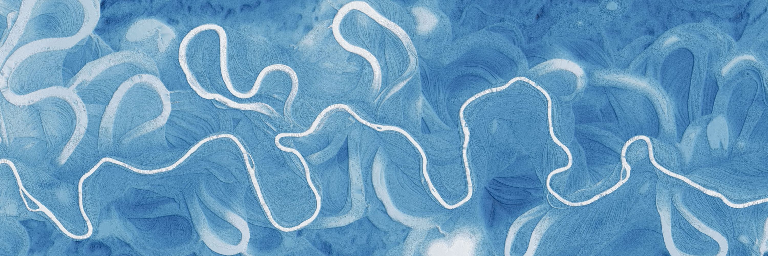
Coastlines in Crisis
Coastal areas like the Outer Banks of North Carolina are shrinking. What can we learn and see from lidar data?
Coastal areas like the Outer Banks of North Carolina are shrinking. What can we learn and see from lidar data?
October 1, 2025 at 5:19 PM
Coastlines in Crisis
Coastal areas like the Outer Banks of North Carolina are shrinking. What can we learn and see from lidar data?
Coastal areas like the Outer Banks of North Carolina are shrinking. What can we learn and see from lidar data?
Check out TopoRivBlender, a new tool to create custom 3D images of topography and hydrography. Uses Blender and the OpenTopography API to produce 3D visualizations for data around the world.
More info:
waterdata.usgs.gov/blog/topo-ri...
github.com/DOI-USGS/top...
More info:
waterdata.usgs.gov/blog/topo-ri...
github.com/DOI-USGS/top...


September 29, 2025 at 5:54 PM
Check out TopoRivBlender, a new tool to create custom 3D images of topography and hydrography. Uses Blender and the OpenTopography API to produce 3D visualizations for data around the world.
More info:
waterdata.usgs.gov/blog/topo-ri...
github.com/DOI-USGS/top...
More info:
waterdata.usgs.gov/blog/topo-ri...
github.com/DOI-USGS/top...
Learn more about the 1m resolution Canadian HRDEM and access via OpenTopography here: opentopography.org/news/opentop...
September 26, 2025 at 2:46 PM
Learn more about the 1m resolution Canadian HRDEM and access via OpenTopography here: opentopography.org/news/opentop...
Missed last week's AGU EPSP Connects Virtual Science Talk by OpenTopography's Chelsea Scott and Cassandra Brigham? Check out the recording!
⬇️
www.youtube.com/live/WJHPdyv...
Topographic change with OpenTopography: Adventures in cloud computing, spatial uncertainty, and impactful applications
⬇️
www.youtube.com/live/WJHPdyv...
Topographic change with OpenTopography: Adventures in cloud computing, spatial uncertainty, and impactful applications

AGU EPSP Connects - September 2025
Topographic change with OpenTopography: Adventures in cloud computing, spatial uncertainty, and impactful applications
www.youtube.com
September 23, 2025 at 6:43 PM
Missed last week's AGU EPSP Connects Virtual Science Talk by OpenTopography's Chelsea Scott and Cassandra Brigham? Check out the recording!
⬇️
www.youtube.com/live/WJHPdyv...
Topographic change with OpenTopography: Adventures in cloud computing, spatial uncertainty, and impactful applications
⬇️
www.youtube.com/live/WJHPdyv...
Topographic change with OpenTopography: Adventures in cloud computing, spatial uncertainty, and impactful applications
Congratulations to EarthScope!
In addition to operating the NSF's National Geophysical Facility (NGF), the EarthScope Consortium is one of three institutions who run OpenTopography (along with the San Diego Supercomputer Center at University of California, San Diego and Arizona State University).
In addition to operating the NSF's National Geophysical Facility (NGF), the EarthScope Consortium is one of three institutions who run OpenTopography (along with the San Diego Supercomputer Center at University of California, San Diego and Arizona State University).

In June 2024, EarthScope Consortium submitted a proposal to the National Science Foundation to operate the National Geophysical Facility (NGF). We are thrilled to announce that EarthScope has been selected as the operator of NSF NGF.
➡️ https://loom.ly/gfaXxQ8
➡️ https://loom.ly/gfaXxQ8

September 17, 2025 at 8:28 PM
Congratulations to EarthScope!
In addition to operating the NSF's National Geophysical Facility (NGF), the EarthScope Consortium is one of three institutions who run OpenTopography (along with the San Diego Supercomputer Center at University of California, San Diego and Arizona State University).
In addition to operating the NSF's National Geophysical Facility (NGF), the EarthScope Consortium is one of three institutions who run OpenTopography (along with the San Diego Supercomputer Center at University of California, San Diego and Arizona State University).
Join OpenTopography's Chelsea Scott and Cassandra Brigham for an AGU EPSP Connects Virtual Science Talk on cloud computing, spatial uncertainty, and impactful applications of topographic change on September 17, 2025 at 11 am ET (8 am PT).
Register to attend: tinyurl.com/sep17epsptalk
Register to attend: tinyurl.com/sep17epsptalk

September 15, 2025 at 6:00 PM
Join OpenTopography's Chelsea Scott and Cassandra Brigham for an AGU EPSP Connects Virtual Science Talk on cloud computing, spatial uncertainty, and impactful applications of topographic change on September 17, 2025 at 11 am ET (8 am PT).
Register to attend: tinyurl.com/sep17epsptalk
Register to attend: tinyurl.com/sep17epsptalk
The stunning sandstone peaks of the Zhangjiajie National Forest Park in China inspired the floating mountains in the movie Avatar, but how did the real-life versions form?
September 11, 2025 at 6:27 PM
The stunning sandstone peaks of the Zhangjiajie National Forest Park in China inspired the floating mountains in the movie Avatar, but how did the real-life versions form?
OpenTopography datasets have been chosen for the NSF's National Artificial Intelligence Research Resource (NAIRR) Pilot Program, aiming to provide access to high-quality datasets that support the advancement of AI literacy, education, and innovation.
Read more ⬇️
opentopography.org/news/nsf-nairr
Read more ⬇️
opentopography.org/news/nsf-nairr

September 10, 2025 at 4:04 PM
OpenTopography datasets have been chosen for the NSF's National Artificial Intelligence Research Resource (NAIRR) Pilot Program, aiming to provide access to high-quality datasets that support the advancement of AI literacy, education, and innovation.
Read more ⬇️
opentopography.org/news/nsf-nairr
Read more ⬇️
opentopography.org/news/nsf-nairr
August's new data releases on OpenTopography include additional USGS 3DEP 1m raster updates (available to academics and OT+ subscribers), and UAV data from landslide reconnaissance monitoring in Utah.
Access the data: opentopography.org/news/august-...
Access the data: opentopography.org/news/august-...


September 9, 2025 at 6:42 PM
August's new data releases on OpenTopography include additional USGS 3DEP 1m raster updates (available to academics and OT+ subscribers), and UAV data from landslide reconnaissance monitoring in Utah.
Access the data: opentopography.org/news/august-...
Access the data: opentopography.org/news/august-...
Reposted by OpenTopography

🎉 It’s official! Today, we announce the launch of CLaSH: Center for Land Surface Hazards an NSF supported initiative to advance the science of cascading geohazards to enable a resilient society.
Follow along as we share updates, opportunities, research, and collaborations! 🌎✨ #CLaSH #NSF
Follow along as we share updates, opportunities, research, and collaborations! 🌎✨ #CLaSH #NSF

September 4, 2025 at 4:22 PM
Reposted by OpenTopography

New post: Comparing LiDAR data from before and after the January 2025 fires in Los Angeles reveals the scale of devastation in ways satellite imagery can’t match.
www.beautifulpublicdata.com/how-lidar-me...
www.beautifulpublicdata.com/how-lidar-me...

How LiDAR measures the toll of climate disasters
Comparing LiDAR data from before and after the January 2025 fires in Los Angeles reveals the scale of devastation in ways satellite imagery can’t match.
www.beautifulpublicdata.com
August 25, 2025 at 2:03 PM
New post: Comparing LiDAR data from before and after the January 2025 fires in Los Angeles reveals the scale of devastation in ways satellite imagery can’t match.
www.beautifulpublicdata.com/how-lidar-me...
www.beautifulpublicdata.com/how-lidar-me...
Topographic differencing of lidar turns wildfire impacts into measurable change. OpenTopography’s Cassandra Brigham is quoted on rapid differencing after the 2025 LA fires.
⬇️
www.beautifulpublicdata.com/how-lidar-me...
⬇️
www.beautifulpublicdata.com/how-lidar-me...

How LiDAR measures the toll of climate disasters
Comparing LiDAR data from before and after the January 2025 fires in Los Angeles reveals the scale of devastation in ways satellite imagery can’t match.
www.beautifulpublicdata.com
August 26, 2025 at 5:11 PM
Topographic differencing of lidar turns wildfire impacts into measurable change. OpenTopography’s Cassandra Brigham is quoted on rapid differencing after the 2025 LA fires.
⬇️
www.beautifulpublicdata.com/how-lidar-me...
⬇️
www.beautifulpublicdata.com/how-lidar-me...
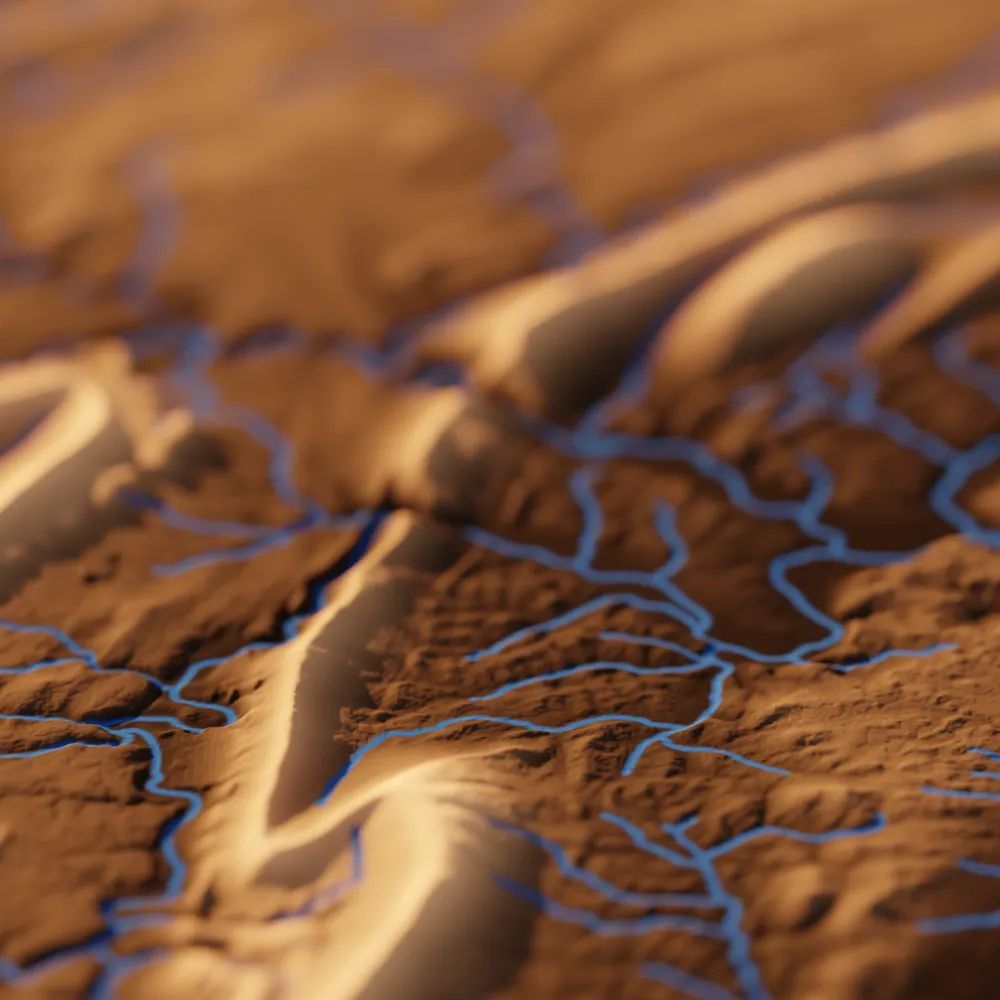
The Martian Mega-Volcano
The tallest volcano on Earth, Hawaii's Mauna Kea, pales in comparison to Olympus Mons on Mars, the largest volcano in the solar system. See what we can learn by studying the topography of planetary bodies.
The tallest volcano on Earth, Hawaii's Mauna Kea, pales in comparison to Olympus Mons on Mars, the largest volcano in the solar system. See what we can learn by studying the topography of planetary bodies.
August 18, 2025 at 6:57 PM
The Martian Mega-Volcano
The tallest volcano on Earth, Hawaii's Mauna Kea, pales in comparison to Olympus Mons on Mars, the largest volcano in the solar system. See what we can learn by studying the topography of planetary bodies.
The tallest volcano on Earth, Hawaii's Mauna Kea, pales in comparison to Olympus Mons on Mars, the largest volcano in the solar system. See what we can learn by studying the topography of planetary bodies.
A number of new topographic datasets are now available on OpenTopography. July dataset additions include the High Resolution Digital Elevation Model of Canada, NOAA coastal lidar of the Indiana coastline, and new LINZ lidar over New Zealand.
opentopography.org/news/july-20...
opentopography.org/news/july-20...


August 13, 2025 at 3:09 PM
A number of new topographic datasets are now available on OpenTopography. July dataset additions include the High Resolution Digital Elevation Model of Canada, NOAA coastal lidar of the Indiana coastline, and new LINZ lidar over New Zealand.
opentopography.org/news/july-20...
opentopography.org/news/july-20...
Reposted by OpenTopography
Box Elder Canyon and Bignell Table, in the loess canyons of western Nebraska, with shadows moving across the landscape as they would on August 9. Uses sun position calculated by {suntools} R package. Visualized with #rayshader. DEM via @opentopography.org
August 11, 2025 at 11:07 PM
Box Elder Canyon and Bignell Table, in the loess canyons of western Nebraska, with shadows moving across the landscape as they would on August 9. Uses sun position calculated by {suntools} R package. Visualized with #rayshader. DEM via @opentopography.org