


OpenTopography
@opentopography.org
Open access to high-resolution, Earth science-oriented topography data, and related tools & resources. US National Science Foundation supported. #lidar https://www.opentopography.org
Pinned
OpenTopography
@opentopography.org
· Mar 13

OpenTopography: Unveiling the Earth's Surface
YouTube video by OpenTopography
youtu.be
New short (3 minute) video answers the question "What is OpenTopography?":
Everyone loves 3D prints of #lidar topography! We put together a how-to tutorial video using the DEMto3D #QGIS plugin to make prints like these examples from @bayesmap.bsky.social. Check it out: opentopography.org/learn/3D_pri...
February 5, 2026 at 3:45 AM
Everyone loves 3D prints of #lidar topography! We put together a how-to tutorial video using the DEMto3D #QGIS plugin to make prints like these examples from @bayesmap.bsky.social. Check it out: opentopography.org/learn/3D_pri...
Since its initiation, OpenTopography data and resources have enabled over 1,500 peer-reviewed publications across increasingly diverse science disciplines, demonstrating the broad applications of open topographic data.
Read more about OT's publication impact
⬇️
opentopography.org/blog/ot-bibl...
Read more about OT's publication impact
⬇️
opentopography.org/blog/ot-bibl...

February 4, 2026 at 8:53 PM
Since its initiation, OpenTopography data and resources have enabled over 1,500 peer-reviewed publications across increasingly diverse science disciplines, demonstrating the broad applications of open topographic data.
Read more about OT's publication impact
⬇️
opentopography.org/blog/ot-bibl...
Read more about OT's publication impact
⬇️
opentopography.org/blog/ot-bibl...
Reposted by OpenTopography
Here’s a nice Saturday Surprise. I just posted 19 new volcano tissue box covers in my Etsy shop. They are 3D printed scale models made using lidar scans from federally funded USGS projects and my photogrammetry. Thanks to @opentopography.org for organizing the data!
phaneritic.etsy.com
phaneritic.etsy.com


January 31, 2026 at 8:46 PM
Here’s a nice Saturday Surprise. I just posted 19 new volcano tissue box covers in my Etsy shop. They are 3D printed scale models made using lidar scans from federally funded USGS projects and my photogrammetry. Thanks to @opentopography.org for organizing the data!
phaneritic.etsy.com
phaneritic.etsy.com
OpenTopography invites you to join a series of weekly, hour-long webinars.
The first webinar introduces OT and our new resources, and the subsequent three are aimed at those with familiarity with lidar who are seeking to make better use of these data.
Register: opentopography.org/news/2026_we...
The first webinar introduces OT and our new resources, and the subsequent three are aimed at those with familiarity with lidar who are seeking to make better use of these data.
Register: opentopography.org/news/2026_we...

January 29, 2026 at 4:01 PM
OpenTopography invites you to join a series of weekly, hour-long webinars.
The first webinar introduces OT and our new resources, and the subsequent three are aimed at those with familiarity with lidar who are seeking to make better use of these data.
Register: opentopography.org/news/2026_we...
The first webinar introduces OT and our new resources, and the subsequent three are aimed at those with familiarity with lidar who are seeking to make better use of these data.
Register: opentopography.org/news/2026_we...
More information about OpenTopography's Advisory Committees and present members can be found at: opentopography.org/about/ac
Advisory Committees | OpenTopography
opentopography.org
January 27, 2026 at 9:20 PM
More information about OpenTopography's Advisory Committees and present members can be found at: opentopography.org/about/ac
Seeking new members for:
Research Communities Advisory Committee
Inclusive Education, Training, and Workforce Development Advisory Committee
Sustainability and Technology Advisory Committee
Research Communities Advisory Committee
Inclusive Education, Training, and Workforce Development Advisory Committee
Sustainability and Technology Advisory Committee
January 27, 2026 at 9:06 PM
Seeking new members for:
Research Communities Advisory Committee
Inclusive Education, Training, and Workforce Development Advisory Committee
Sustainability and Technology Advisory Committee
Research Communities Advisory Committee
Inclusive Education, Training, and Workforce Development Advisory Committee
Sustainability and Technology Advisory Committee
We're recruiting new members to serve on OpenTopography's advisory committees! These committees represent OT's users and ensure that activities are aligned with the needs and initiatives of the scientific and educational communities.
Learn more & apply: opentopography.org/news/AC_nomi...
Learn more & apply: opentopography.org/news/AC_nomi...

January 27, 2026 at 9:06 PM
We're recruiting new members to serve on OpenTopography's advisory committees! These committees represent OT's users and ensure that activities are aligned with the needs and initiatives of the scientific and educational communities.
Learn more & apply: opentopography.org/news/AC_nomi...
Learn more & apply: opentopography.org/news/AC_nomi...
Reposted by OpenTopography
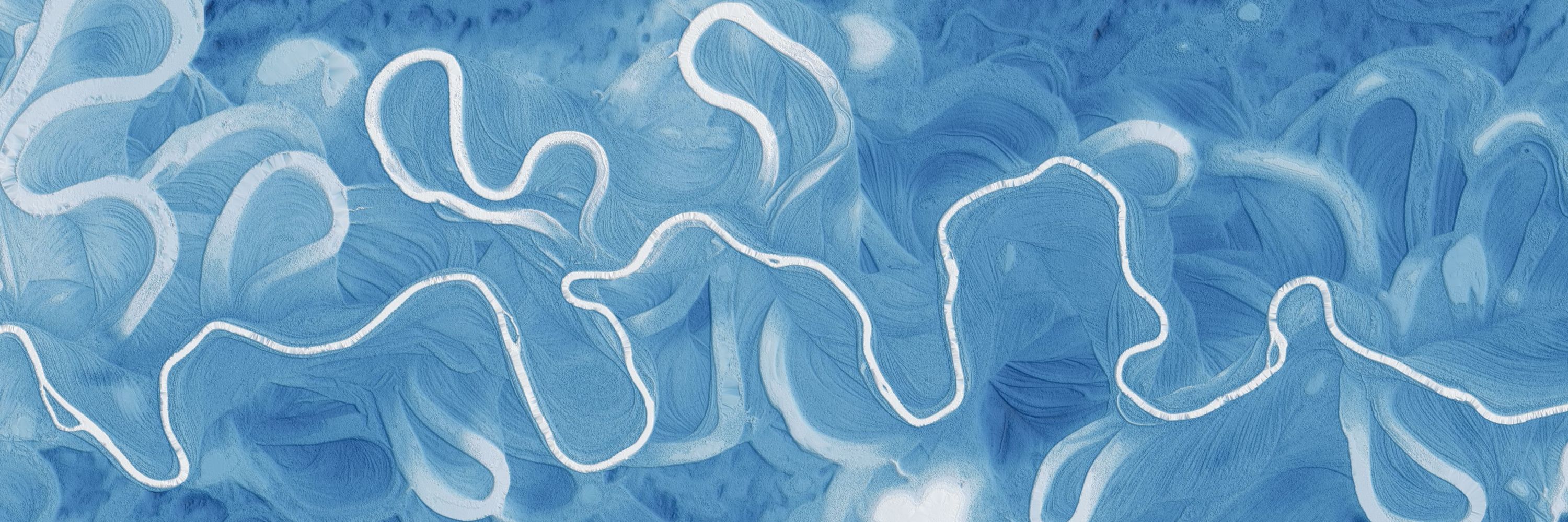
Cipriano Hills, Organ Pipe Cactus NM (NE of Quitobaquito Springs). I hope you like this but I really just made it for my own nostalgic enjoyment. Data from @opentopography.org, visualized with #rayshader.
January 23, 2026 at 3:18 AM
Cipriano Hills, Organ Pipe Cactus NM (NE of Quitobaquito Springs). I hope you like this but I really just made it for my own nostalgic enjoyment. Data from @opentopography.org, visualized with #rayshader.
Check out the latest datasets now available on OpenTopography, which include over a dozen new USGS 3DEP datasets, new NOAA Coastal Lidar, and data collected over the Eaton Fire in Los Angeles, California.
opentopography.org/news/decembe...
opentopography.org/news/decembe...


January 12, 2026 at 5:43 PM
Check out the latest datasets now available on OpenTopography, which include over a dozen new USGS 3DEP datasets, new NOAA Coastal Lidar, and data collected over the Eaton Fire in Los Angeles, California.
opentopography.org/news/decembe...
opentopography.org/news/decembe...
Please join OpenTopo's Chelsea Scott & Cassandra Brigham for a WHPC@SDSC Professional Speaker Series talk.
Topographic change with OpenTopography: Adventures in cloud computing, spatial uncertainty, and impactful applications
Feb. 25, 2026 at 1–2 pm PT
Register: www.sdsc.edu/events/20260...
Topographic change with OpenTopography: Adventures in cloud computing, spatial uncertainty, and impactful applications
Feb. 25, 2026 at 1–2 pm PT
Register: www.sdsc.edu/events/20260...

January 7, 2026 at 8:06 PM
Please join OpenTopo's Chelsea Scott & Cassandra Brigham for a WHPC@SDSC Professional Speaker Series talk.
Topographic change with OpenTopography: Adventures in cloud computing, spatial uncertainty, and impactful applications
Feb. 25, 2026 at 1–2 pm PT
Register: www.sdsc.edu/events/20260...
Topographic change with OpenTopography: Adventures in cloud computing, spatial uncertainty, and impactful applications
Feb. 25, 2026 at 1–2 pm PT
Register: www.sdsc.edu/events/20260...
Reposted by OpenTopography

The NSF National Geophysical Facility will be expanding support for near-surface geophysics. Your input can help shape future efforts for research and teaching with near-surface geophysics!
Please take a few minutes to complete this survey ➡️ https://loom.ly/tVEZXlE
Please take a few minutes to complete this survey ➡️ https://loom.ly/tVEZXlE

January 7, 2026 at 7:20 PM
The NSF National Geophysical Facility will be expanding support for near-surface geophysics. Your input can help shape future efforts for research and teaching with near-surface geophysics!
Please take a few minutes to complete this survey ➡️ https://loom.ly/tVEZXlE
Please take a few minutes to complete this survey ➡️ https://loom.ly/tVEZXlE
At #AGU25? Be sure to check out these presentations by OpenTopography team members!
OT at AGU: opentopography.org/news/opentop...
OT at AGU: opentopography.org/news/opentop...


December 16, 2025 at 5:28 PM
At #AGU25? Be sure to check out these presentations by OpenTopography team members!
OT at AGU: opentopography.org/news/opentop...
OT at AGU: opentopography.org/news/opentop...
Thanks for spotting & the mention! We've given away at least 10k of these stickers over the years and it's always fun to see where they end up!
December 13, 2025 at 1:01 AM
Thanks for spotting & the mention! We've given away at least 10k of these stickers over the years and it's always fun to see where they end up!
Reposted by OpenTopography

Join us at our #AGU25 poster to discover how we harnesses airborne & satellite #lidar data using advanced workflows to uncover powerful insights on forest structure, biomass, and how landscapes change over time. agu.confex.com/agu/agu25/me...
#OpenScience #WildfireRecovery #EcosystemChange #RStats
#OpenScience #WildfireRecovery #EcosystemChange #RStats

December 10, 2025 at 4:09 PM
Join us at our #AGU25 poster to discover how we harnesses airborne & satellite #lidar data using advanced workflows to uncover powerful insights on forest structure, biomass, and how landscapes change over time. agu.confex.com/agu/agu25/me...
#OpenScience #WildfireRecovery #EcosystemChange #RStats
#OpenScience #WildfireRecovery #EcosystemChange #RStats
Reposted by OpenTopography
I want to give a shout out to the good folks at @opentopography.org for making it so EASY to search for and download publicly available digital elevation models and point cloud data sets. They are a spectacular resources that I use a lot in my classes! Data citations for boxes are at listings' end.
Nearly half the boxes are sold after only an hour! Thanks everyone. Still some great ones left in the store
December 10, 2025 at 5:52 PM
I want to give a shout out to the good folks at @opentopography.org for making it so EASY to search for and download publicly available digital elevation models and point cloud data sets. They are a spectacular resources that I use a lot in my classes! Data citations for boxes are at listings' end.
Thanks for the shout out! We love the tissue boxes.
December 10, 2025 at 7:54 PM
Thanks for the shout out! We love the tissue boxes.
November's new data releases on OpenTopography include a new Community Dataspace dataset and USGS 3DEP coverage in California, plus NOAA Coastal Lidar over Ohio.
Read more and access data: opentopography.org/news/novembe...
Read more and access data: opentopography.org/news/novembe...


December 10, 2025 at 5:02 PM
November's new data releases on OpenTopography include a new Community Dataspace dataset and USGS 3DEP coverage in California, plus NOAA Coastal Lidar over Ohio.
Read more and access data: opentopography.org/news/novembe...
Read more and access data: opentopography.org/news/novembe...
Final year for NSF-supported NCALM seed project proposals! Great opportunity for students to get free #lidar for research. Focus this year is projects in the Alaskan Arctic.
Data become open via OT. To date there are 252 NCALM datasets available on OT (red ⬇️)
Info: ncalm.cive.uh.edu/seed-proposals
Data become open via OT. To date there are 252 NCALM datasets available on OT (red ⬇️)
Info: ncalm.cive.uh.edu/seed-proposals

December 10, 2025 at 4:46 PM
Final year for NSF-supported NCALM seed project proposals! Great opportunity for students to get free #lidar for research. Focus this year is projects in the Alaskan Arctic.
Data become open via OT. To date there are 252 NCALM datasets available on OT (red ⬇️)
Info: ncalm.cive.uh.edu/seed-proposals
Data become open via OT. To date there are 252 NCALM datasets available on OT (red ⬇️)
Info: ncalm.cive.uh.edu/seed-proposals
Connect with OpenTopography at #AGU25 in New Orleans next week! Our booth (908) is staffed by the OT team and is a great chance to ask questions, provide feedback, or to discuss lidar, high resolution topography, and cyberinfrastructure.
opentopography.org/news/opentop...
opentopography.org/news/opentop...

December 9, 2025 at 3:02 PM
Connect with OpenTopography at #AGU25 in New Orleans next week! Our booth (908) is staffed by the OT team and is a great chance to ask questions, provide feedback, or to discuss lidar, high resolution topography, and cyberinfrastructure.
opentopography.org/news/opentop...
opentopography.org/news/opentop...
Reposted by OpenTopography
Discover how #lidar reveals wildfire impacts & landscape recovery. Case studies in Arizona & Los Angeles show how 3D data helps us quantify canopy loss, hazards, & restoration after major fires. #LAfires #Kaibab
Watch the new #wildfire science video: www.youtube.com/watch?v=7Joz...
Watch the new #wildfire science video: www.youtube.com/watch?v=7Joz...

Measuring Wildfire Impact: Lidar Analysis of Arizona and California Fires
YouTube video by OpenForest4D
www.youtube.com
December 4, 2025 at 3:28 PM
Discover how #lidar reveals wildfire impacts & landscape recovery. Case studies in Arizona & Los Angeles show how 3D data helps us quantify canopy loss, hazards, & restoration after major fires. #LAfires #Kaibab
Watch the new #wildfire science video: www.youtube.com/watch?v=7Joz...
Watch the new #wildfire science video: www.youtube.com/watch?v=7Joz...
Reposted by OpenTopography
Generate #forestry products from #lidar topography data with lidR! Reproducible R notebook guides users through #pointcloud filtering, raster generation & forest metrics extraction to produce key outputs like canopy height models. Explore notebook: github.com/OpenForest4D...
#googlecolab #geospatial
#googlecolab #geospatial


December 1, 2025 at 7:22 PM
Generate #forestry products from #lidar topography data with lidR! Reproducible R notebook guides users through #pointcloud filtering, raster generation & forest metrics extraction to produce key outputs like canopy height models. Explore notebook: github.com/OpenForest4D...
#googlecolab #geospatial
#googlecolab #geospatial
This video is part of a series from OpenTopography aimed at expanding community engagement. The series explores what we can learn about Earth’s surface, geologic processes, and natural hazards from remote sensing data like lidar.
November 10, 2025 at 5:26 PM
This video is part of a series from OpenTopography aimed at expanding community engagement. The series explores what we can learn about Earth’s surface, geologic processes, and natural hazards from remote sensing data like lidar.
For the last several decades, scientists have been developing a way to make our maps more reliable with point cloud data collected by lidar. Lidar is an accurate method that helps scientists to map cities, landscapes, and places that were previously difficult or dangerous to access.
November 10, 2025 at 5:26 PM
For the last several decades, scientists have been developing a way to make our maps more reliable with point cloud data collected by lidar. Lidar is an accurate method that helps scientists to map cities, landscapes, and places that were previously difficult or dangerous to access.
New for educators! Lab Exercise: Using lidar to track Lake Michigan bluff retreat and inform local communities
Designed for community college and intro-level geomorph, enviro sci, and GIS courses, students use lidar data to learn about dynamic coastal erosion.
opentopography.org/learn/WI_blu...
Designed for community college and intro-level geomorph, enviro sci, and GIS courses, students use lidar data to learn about dynamic coastal erosion.
opentopography.org/learn/WI_blu...

November 3, 2025 at 10:22 PM
New for educators! Lab Exercise: Using lidar to track Lake Michigan bluff retreat and inform local communities
Designed for community college and intro-level geomorph, enviro sci, and GIS courses, students use lidar data to learn about dynamic coastal erosion.
opentopography.org/learn/WI_blu...
Designed for community college and intro-level geomorph, enviro sci, and GIS courses, students use lidar data to learn about dynamic coastal erosion.
opentopography.org/learn/WI_blu...