


milos makes maps
@milos-makes-maps.bsky.social
I paint the world with #rstats and teach you how to unleash your inner #map artist. Join my map adventures and tutorials now:
https://youtube.com/@milos-makes-maps
https://youtube.com/@milos-makes-maps
Pinned

Milos Makes Maps
I paint the world with R and teach you how to unleash your inner map artist. Join my map adventures and tutorials now!
youtube.com
Hey everyone! 🌍 Welcome to my page! I'm Milos, and I bring the world to life with maps. 🎨 Join me on a journey to unleash your inner map artist. Enjoy my creations, connect with me, and dive into my map adventures and tutorials!
▶️ youtube.com/@milos-makes...)
▶️ youtube.com/@milos-makes...)
Love it! Thank you for putting my tutorial to good use and for tagging me!

3D Tanaka contour map of Scotland with #rayshader for Day 6 of the #30DayMapChallenge - Dimensions.
Code: github.com/rajodm/30Day...
Thanks @milos-makes-maps.bsky.social for the helpful tutorial!
#dataviz #rstats #ggplot2
Code: github.com/rajodm/30Day...
Thanks @milos-makes-maps.bsky.social for the helpful tutorial!
#dataviz #rstats #ggplot2

November 8, 2025 at 5:49 PM
Love it! Thank you for putting my tutorial to good use and for tagging me!
Lovely implementation of my river basin tutorial! Thank you!
Here is the tutorial 👉 youtu.be/HugGwjogPv0
Here is the tutorial 👉 youtu.be/HugGwjogPv0
November 4, 2025 at 12:42 PM
Lovely implementation of my river basin tutorial! Thank you!
Here is the tutorial 👉 youtu.be/HugGwjogPv0
Here is the tutorial 👉 youtu.be/HugGwjogPv0
From zero to a cinematic lighthouse map in 20 minutes.
My new hands-on tutorial shows you how to leverage Python to make stunning pulsing-beacon animation
Watch here 👉 youtu.be/BQSuZgzheNk
Which coastline should we light up next?
#Python #GIS #Mapping
My new hands-on tutorial shows you how to leverage Python to make stunning pulsing-beacon animation
Watch here 👉 youtu.be/BQSuZgzheNk
Which coastline should we light up next?
#Python #GIS #Mapping

Can You Create Stunning Lighthouse Maps with Python in Just 20 Minutes?
YouTube video by Milos Makes Maps
youtu.be
November 2, 2025 at 1:06 PM
From zero to a cinematic lighthouse map in 20 minutes.
My new hands-on tutorial shows you how to leverage Python to make stunning pulsing-beacon animation
Watch here 👉 youtu.be/BQSuZgzheNk
Which coastline should we light up next?
#Python #GIS #Mapping
My new hands-on tutorial shows you how to leverage Python to make stunning pulsing-beacon animation
Watch here 👉 youtu.be/BQSuZgzheNk
Which coastline should we light up next?
#Python #GIS #Mapping
I love how it looks Stebe! Awesome work and thank you for bringing my tutorial to life!
Tutorial 👉 youtu.be/E7F75OFXu-I
Tutorial 👉 youtu.be/E7F75OFXu-I
November 1, 2025 at 7:14 AM
I love how it looks Stebe! Awesome work and thank you for bringing my tutorial to life!
Tutorial 👉 youtu.be/E7F75OFXu-I
Tutorial 👉 youtu.be/E7F75OFXu-I
I used to stare at OpenStreetMap and imagine the city lifting off the screen. Today it does. I’ve just published a step-by-step guide to turn raw OSM into a fully styled 3D city.
👉 youtu.be/E7F75OFXu-I
Build with me!
👉 youtu.be/E7F75OFXu-I
Build with me!

I Built a 3D City Using Only Code
YouTube video by Milos Makes Maps
youtu.be
October 26, 2025 at 3:49 PM
I used to stare at OpenStreetMap and imagine the city lifting off the screen. Today it does. I’ve just published a step-by-step guide to turn raw OSM into a fully styled 3D city.
👉 youtu.be/E7F75OFXu-I
Build with me!
👉 youtu.be/E7F75OFXu-I
Build with me!
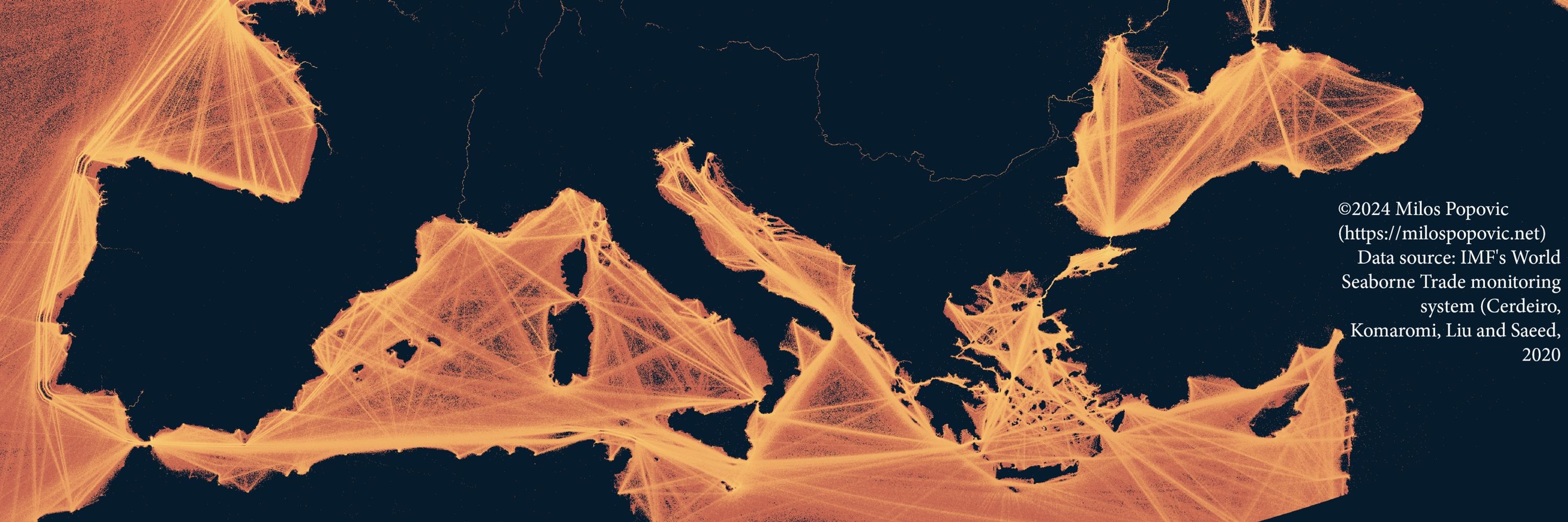
Reposted by milos makes maps

🇧🇷 L🅐🅝🅓 P🅡🅞🅓🅤🅒🅣🅘🅥🅘🅣🅨 D🅨🅝🅐🅜🅘🅒🅢 🅘🅝 B🅡🅐🅩🅘🅛
𝖦𝗋𝖾𝖾𝗇𝗂𝗇𝗀 𝗂𝗇 𝗍𝗁𝖾 𝖠𝗆𝖺𝗓𝗈𝗇 & 𝗌𝗈𝗎𝗍𝗁 𝗌𝗁𝗈𝗐𝗌 𝗋𝗂𝗌𝗂𝗇𝗀 𝗉𝗋𝗈𝖽𝗎𝖼𝗍𝗂𝗏𝗂𝗍𝗒 🌱
𝖡𝗎𝗍 𝗈𝗋𝖺𝗇𝗀𝖾 & 𝗒𝖾𝗅𝗅𝗈𝗐 𝗓𝗈𝗇𝖾𝗌 𝗋𝖾𝗏𝖾𝖺𝗅 𝗌𝗍𝗋𝖾𝗌𝗌 𝖽𝖾𝖿𝗈𝗋𝖾𝗌𝗍𝖺𝗍𝗂𝗈𝗇, 𝖽𝗋𝗈𝗎𝗀𝗁𝗍 & 𝖼𝗅𝗂𝗆𝖺𝗍𝖾 𝗉𝗋𝖾𝗌𝗌𝗎𝗋𝖾 𝗋𝖾𝖽𝗎𝖼𝗂𝗇𝗀 𝗋𝖾𝗌𝗂𝗅𝗂𝖾𝗇𝖼𝖾 🌾🔥
𝖧𝗈𝗐 ? 𝗌𝖾𝖾 @milos-makes-maps.bsky.social 𝗍𝗎𝗍
#𝖫𝖺𝗇𝖽𝖣𝖾𝗀𝗋𝖺𝖽𝖺𝗍𝗂𝗈𝗇 #𝖡𝗋𝖺𝗓𝗂𝗅 #𝖤𝖺𝗋𝗍𝗁𝖮𝖻𝗌𝖾𝗋𝗏𝖺𝗍𝗂𝗈𝗇 #𝖱𝗌𝗍𝖺𝗍s
𝖦𝗋𝖾𝖾𝗇𝗂𝗇𝗀 𝗂𝗇 𝗍𝗁𝖾 𝖠𝗆𝖺𝗓𝗈𝗇 & 𝗌𝗈𝗎𝗍𝗁 𝗌𝗁𝗈𝗐𝗌 𝗋𝗂𝗌𝗂𝗇𝗀 𝗉𝗋𝗈𝖽𝗎𝖼𝗍𝗂𝗏𝗂𝗍𝗒 🌱
𝖡𝗎𝗍 𝗈𝗋𝖺𝗇𝗀𝖾 & 𝗒𝖾𝗅𝗅𝗈𝗐 𝗓𝗈𝗇𝖾𝗌 𝗋𝖾𝗏𝖾𝖺𝗅 𝗌𝗍𝗋𝖾𝗌𝗌 𝖽𝖾𝖿𝗈𝗋𝖾𝗌𝗍𝖺𝗍𝗂𝗈𝗇, 𝖽𝗋𝗈𝗎𝗀𝗁𝗍 & 𝖼𝗅𝗂𝗆𝖺𝗍𝖾 𝗉𝗋𝖾𝗌𝗌𝗎𝗋𝖾 𝗋𝖾𝖽𝗎𝖼𝗂𝗇𝗀 𝗋𝖾𝗌𝗂𝗅𝗂𝖾𝗇𝖼𝖾 🌾🔥
𝖧𝗈𝗐 ? 𝗌𝖾𝖾 @milos-makes-maps.bsky.social 𝗍𝗎𝗍
#𝖫𝖺𝗇𝖽𝖣𝖾𝗀𝗋𝖺𝖽𝖺𝗍𝗂𝗈𝗇 #𝖡𝗋𝖺𝗓𝗂𝗅 #𝖤𝖺𝗋𝗍𝗁𝖮𝖻𝗌𝖾𝗋𝗏𝖺𝗍𝗂𝗈𝗇 #𝖱𝗌𝗍𝖺𝗍s

October 15, 2025 at 9:53 PM
🇧🇷 L🅐🅝🅓 P🅡🅞🅓🅤🅒🅣🅘🅥🅘🅣🅨 D🅨🅝🅐🅜🅘🅒🅢 🅘🅝 B🅡🅐🅩🅘🅛
𝖦𝗋𝖾𝖾𝗇𝗂𝗇𝗀 𝗂𝗇 𝗍𝗁𝖾 𝖠𝗆𝖺𝗓𝗈𝗇 & 𝗌𝗈𝗎𝗍𝗁 𝗌𝗁𝗈𝗐𝗌 𝗋𝗂𝗌𝗂𝗇𝗀 𝗉𝗋𝗈𝖽𝗎𝖼𝗍𝗂𝗏𝗂𝗍𝗒 🌱
𝖡𝗎𝗍 𝗈𝗋𝖺𝗇𝗀𝖾 & 𝗒𝖾𝗅𝗅𝗈𝗐 𝗓𝗈𝗇𝖾𝗌 𝗋𝖾𝗏𝖾𝖺𝗅 𝗌𝗍𝗋𝖾𝗌𝗌 𝖽𝖾𝖿𝗈𝗋𝖾𝗌𝗍𝖺𝗍𝗂𝗈𝗇, 𝖽𝗋𝗈𝗎𝗀𝗁𝗍 & 𝖼𝗅𝗂𝗆𝖺𝗍𝖾 𝗉𝗋𝖾𝗌𝗌𝗎𝗋𝖾 𝗋𝖾𝖽𝗎𝖼𝗂𝗇𝗀 𝗋𝖾𝗌𝗂𝗅𝗂𝖾𝗇𝖼𝖾 🌾🔥
𝖧𝗈𝗐 ? 𝗌𝖾𝖾 @milos-makes-maps.bsky.social 𝗍𝗎𝗍
#𝖫𝖺𝗇𝖽𝖣𝖾𝗀𝗋𝖺𝖽𝖺𝗍𝗂𝗈𝗇 #𝖡𝗋𝖺𝗓𝗂𝗅 #𝖤𝖺𝗋𝗍𝗁𝖮𝖻𝗌𝖾𝗋𝗏𝖺𝗍𝗂𝗈𝗇 #𝖱𝗌𝗍𝖺𝗍s
𝖦𝗋𝖾𝖾𝗇𝗂𝗇𝗀 𝗂𝗇 𝗍𝗁𝖾 𝖠𝗆𝖺𝗓𝗈𝗇 & 𝗌𝗈𝗎𝗍𝗁 𝗌𝗁𝗈𝗐𝗌 𝗋𝗂𝗌𝗂𝗇𝗀 𝗉𝗋𝗈𝖽𝗎𝖼𝗍𝗂𝗏𝗂𝗍𝗒 🌱
𝖡𝗎𝗍 𝗈𝗋𝖺𝗇𝗀𝖾 & 𝗒𝖾𝗅𝗅𝗈𝗐 𝗓𝗈𝗇𝖾𝗌 𝗋𝖾𝗏𝖾𝖺𝗅 𝗌𝗍𝗋𝖾𝗌𝗌 𝖽𝖾𝖿𝗈𝗋𝖾𝗌𝗍𝖺𝗍𝗂𝗈𝗇, 𝖽𝗋𝗈𝗎𝗀𝗁𝗍 & 𝖼𝗅𝗂𝗆𝖺𝗍𝖾 𝗉𝗋𝖾𝗌𝗌𝗎𝗋𝖾 𝗋𝖾𝖽𝗎𝖼𝗂𝗇𝗀 𝗋𝖾𝗌𝗂𝗅𝗂𝖾𝗇𝖼𝖾 🌾🔥
𝖧𝗈𝗐 ? 𝗌𝖾𝖾 @milos-makes-maps.bsky.social 𝗍𝗎𝗍
#𝖫𝖺𝗇𝖽𝖣𝖾𝗀𝗋𝖺𝖽𝖺𝗍𝗂𝗈𝗇 #𝖡𝗋𝖺𝗓𝗂𝗅 #𝖤𝖺𝗋𝗍𝗁𝖮𝖻𝗌𝖾𝗋𝗏𝖺𝗍𝗂𝗈𝗇 #𝖱𝗌𝗍𝖺𝗍s
Nicely done!
Here's the tutorial 👉 youtu.be/JfDW8P51MmA
Here's the tutorial 👉 youtu.be/JfDW8P51MmA
October 10, 2025 at 6:36 PM
Nicely done!
Here's the tutorial 👉 youtu.be/JfDW8P51MmA
Here's the tutorial 👉 youtu.be/JfDW8P51MmA
I’ve been deep in R for GIS mapping for years, but today marks a thrilling pivot: my very first Python tutorial is live!
We’ll extract Google’s latest satellite embeddings, run k-means analysis, and map our results
Everyone, watch the tutorial youtu.be/WjoB7mou2n8
We’ll extract Google’s latest satellite embeddings, run k-means analysis, and map our results
Everyone, watch the tutorial youtu.be/WjoB7mou2n8

Python: The Secret Weapon for Analyzing Google Earth Engine Data
YouTube video by Milos Makes Maps
youtu.be
October 5, 2025 at 1:26 PM
I’ve been deep in R for GIS mapping for years, but today marks a thrilling pivot: my very first Python tutorial is live!
We’ll extract Google’s latest satellite embeddings, run k-means analysis, and map our results
Everyone, watch the tutorial youtu.be/WjoB7mou2n8
We’ll extract Google’s latest satellite embeddings, run k-means analysis, and map our results
Everyone, watch the tutorial youtu.be/WjoB7mou2n8
How far can you go in 30 minutes—from your doorstep? ⏱️
I just dropped a from-scratch tutorial to build travel-time maps in R (OSM → network → isochrones → crisp basemap).
Ship your city now.
🎥 Watch now: www.youtube.com/watch?v=M-O0...
I just dropped a from-scratch tutorial to build travel-time maps in R (OSM → network → isochrones → crisp basemap).
Ship your city now.
🎥 Watch now: www.youtube.com/watch?v=M-O0...

30-Minute Travel Maps: The Secret to Fast Exploration
YouTube video by Milos Makes Maps
www.youtube.com
September 14, 2025 at 2:13 PM
How far can you go in 30 minutes—from your doorstep? ⏱️
I just dropped a from-scratch tutorial to build travel-time maps in R (OSM → network → isochrones → crisp basemap).
Ship your city now.
🎥 Watch now: www.youtube.com/watch?v=M-O0...
I just dropped a from-scratch tutorial to build travel-time maps in R (OSM → network → isochrones → crisp basemap).
Ship your city now.
🎥 Watch now: www.youtube.com/watch?v=M-O0...
Reposted by milos makes maps
#geodata #mapping #datavis
Precipitation (rain and snow) vs temperature in Germany
by @milos-makes-maps.bsky.social over on the birdsite
Precipitation (rain and snow) vs temperature in Germany
by @milos-makes-maps.bsky.social over on the birdsite

September 6, 2025 at 8:26 AM
#geodata #mapping #datavis
Precipitation (rain and snow) vs temperature in Germany
by @milos-makes-maps.bsky.social over on the birdsite
Precipitation (rain and snow) vs temperature in Germany
by @milos-makes-maps.bsky.social over on the birdsite
Thank you dear Miska!
#mapping #geodata #datavis #datascience
Iberian peninsula perspiration and temperature map
from @milos-makes-maps.bsky.social over on linkedin
tutorial:
lnkd.in/eYABTD6f
mapping book:
payhip.com/b/MH9Ot
linkedin post : www.linkedin.com/posts/milos-...
Iberian peninsula perspiration and temperature map
from @milos-makes-maps.bsky.social over on linkedin
tutorial:
lnkd.in/eYABTD6f
mapping book:
payhip.com/b/MH9Ot
linkedin post : www.linkedin.com/posts/milos-...


August 31, 2025 at 9:17 AM
Thank you dear Miska!
Google Earth Engine now delivers annual 10 m Satellite Embeddings (64 bands per pixel!
In my new tutorial, I walk you through:
✅Loading & exploring AlphaEarth embeddings in R
✅Sampling & k-means clustering
✅Visualizing beautiful results
👉 youtu.be/dmtNAYb5woE
#GoogleEarthEngine #AlphaEarth #GIS
In my new tutorial, I walk you through:
✅Loading & exploring AlphaEarth embeddings in R
✅Sampling & k-means clustering
✅Visualizing beautiful results
👉 youtu.be/dmtNAYb5woE
#GoogleEarthEngine #AlphaEarth #GIS

Revolutionizing Land Cover Analysis with Google Earth Engine!
YouTube video by Milos Makes Maps
youtu.be
August 10, 2025 at 1:21 PM
Google Earth Engine now delivers annual 10 m Satellite Embeddings (64 bands per pixel!
In my new tutorial, I walk you through:
✅Loading & exploring AlphaEarth embeddings in R
✅Sampling & k-means clustering
✅Visualizing beautiful results
👉 youtu.be/dmtNAYb5woE
#GoogleEarthEngine #AlphaEarth #GIS
In my new tutorial, I walk you through:
✅Loading & exploring AlphaEarth embeddings in R
✅Sampling & k-means clustering
✅Visualizing beautiful results
👉 youtu.be/dmtNAYb5woE
#GoogleEarthEngine #AlphaEarth #GIS
Earth Engine now hosts annual 10 m Satellite Embeddings (64 bands per pixel) powered by the new AlphaEarth Foundations model.
My next video on YouTube (milos-makes-maps) will show how to run part of its workflow in R. Subscribe to catch it 👉🏻 youtube.com/@milos-makes...
#AlphaEarth #Rstats #GIS
My next video on YouTube (milos-makes-maps) will show how to run part of its workflow in R. Subscribe to catch it 👉🏻 youtube.com/@milos-makes...
#AlphaEarth #Rstats #GIS

Milos Makes Maps
I paint the world with R and teach you how to unleash your inner map artist. Join my map adventures and tutorials now!
lnkd.in
August 3, 2025 at 9:03 AM
Earth Engine now hosts annual 10 m Satellite Embeddings (64 bands per pixel) powered by the new AlphaEarth Foundations model.
My next video on YouTube (milos-makes-maps) will show how to run part of its workflow in R. Subscribe to catch it 👉🏻 youtube.com/@milos-makes...
#AlphaEarth #Rstats #GIS
My next video on YouTube (milos-makes-maps) will show how to run part of its workflow in R. Subscribe to catch it 👉🏻 youtube.com/@milos-makes...
#AlphaEarth #Rstats #GIS
Thank you for spreading the word @miskaknapek.bsky.social ♥️
#mapping #geodata Milos @milos-makes-maps.bsky.social notes on linkedin he's devleoping a python alternative to #rayshader in #Rlang.
Built with Vulkan + Rust + WebGPU :-)))
github repository:
github.com/milos-agatho...
- star the repository to help it gain traction
Built with Vulkan + Rust + WebGPU :-)))
github repository:
github.com/milos-agatho...
- star the repository to help it gain traction

August 3, 2025 at 8:58 AM
Thank you for spreading the word @miskaknapek.bsky.social ♥️
Reposted by milos makes maps
ps. Milos here - @milos-makes-maps.bsky.social - has released a #GIS #geodata programming book with R #rlang
It ought to be good, knowing Milos.
payhip.com/b/MH9Ot
It ought to be good, knowing Milos.
payhip.com/b/MH9Ot

July 21, 2025 at 2:55 PM
ps. Milos here - @milos-makes-maps.bsky.social - has released a #GIS #geodata programming book with R #rlang
It ought to be good, knowing Milos.
payhip.com/b/MH9Ot
It ought to be good, knowing Milos.
payhip.com/b/MH9Ot
Ready to create stunning 3D tree cover maps entirely for free?
My new tutorial guides you step-by-step on turning free satellite data from Google Dynamic World into high-quality visualizations.
Watch here 👉🏻 youtu.be/gyfy6HdbcLw
#GIS #RemoteSensing #3DMapping #ForestConservation #RStats
My new tutorial guides you step-by-step on turning free satellite data from Google Dynamic World into high-quality visualizations.
Watch here 👉🏻 youtu.be/gyfy6HdbcLw
#GIS #RemoteSensing #3DMapping #ForestConservation #RStats
How to Make Awesome 3D Tree Cover Maps from Free Satellite Data!
YouTube video by Milos Makes Maps
youtu.be
July 6, 2025 at 10:57 AM
Ready to create stunning 3D tree cover maps entirely for free?
My new tutorial guides you step-by-step on turning free satellite data from Google Dynamic World into high-quality visualizations.
Watch here 👉🏻 youtu.be/gyfy6HdbcLw
#GIS #RemoteSensing #3DMapping #ForestConservation #RStats
My new tutorial guides you step-by-step on turning free satellite data from Google Dynamic World into high-quality visualizations.
Watch here 👉🏻 youtu.be/gyfy6HdbcLw
#GIS #RemoteSensing #3DMapping #ForestConservation #RStats
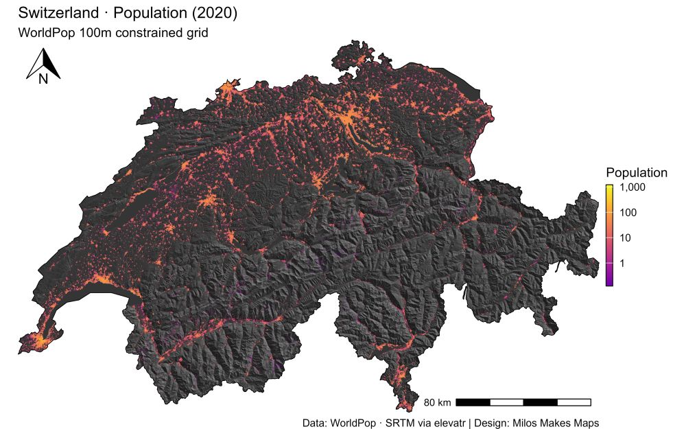
Reposted by milos makes maps

Beautiful and informative map 🇨🇭
Want the secret to stunning maps like this Switzerland hillshade & population visualization?
My latest YouTube tutorial shows you exactly how!
🎬 Watch here 👉🏻 youtu.be/2dNIultQQ4Y
#GIS #Cartography #RStats #DataViz #MilosMakesMaps
My latest YouTube tutorial shows you exactly how!
🎬 Watch here 👉🏻 youtu.be/2dNIultQQ4Y
#GIS #Cartography #RStats #DataViz #MilosMakesMaps
June 8, 2025 at 1:37 PM
Beautiful and informative map 🇨🇭
Want the secret to stunning maps like this Switzerland hillshade & population visualization?
My latest YouTube tutorial shows you exactly how!
🎬 Watch here 👉🏻 youtu.be/2dNIultQQ4Y
#GIS #Cartography #RStats #DataViz #MilosMakesMaps
My latest YouTube tutorial shows you exactly how!
🎬 Watch here 👉🏻 youtu.be/2dNIultQQ4Y
#GIS #Cartography #RStats #DataViz #MilosMakesMaps
June 8, 2025 at 1:07 PM
Want the secret to stunning maps like this Switzerland hillshade & population visualization?
My latest YouTube tutorial shows you exactly how!
🎬 Watch here 👉🏻 youtu.be/2dNIultQQ4Y
#GIS #Cartography #RStats #DataViz #MilosMakesMaps
My latest YouTube tutorial shows you exactly how!
🎬 Watch here 👉🏻 youtu.be/2dNIultQQ4Y
#GIS #Cartography #RStats #DataViz #MilosMakesMaps
Love it! Thank you for watching my tutorial!!

Played with #Rstats and {rayshader} to make this #Quebec population density map, thanks to a tutorial by @milos-makes-maps.bsky.social ✌️⚜️
Code 👉 github.com/datacarvel/q...
Code 👉 github.com/datacarvel/q...

June 2, 2025 at 7:19 AM
Love it! Thank you for watching my tutorial!!
Reposted by milos makes maps

Better engage, folks. Otherwise, this content might only be fit for LinkedIn. You've been warned.
Want to turn raw wind data into a mesmerizing, animated map?
With R, it’s easier than you think.
My new tutorial shows you how, step by step.
Let’s catch the breeze. ⤵️
youtu.be/EmVbVTqwoMU
#GIS #DataViz #gganimate #metR #WindMap #ClimateData #SpatialAnalysis #MilosMakesMaps
With R, it’s easier than you think.
My new tutorial shows you how, step by step.
Let’s catch the breeze. ⤵️
youtu.be/EmVbVTqwoMU
#GIS #DataViz #gganimate #metR #WindMap #ClimateData #SpatialAnalysis #MilosMakesMaps
May 26, 2025 at 12:35 AM
Better engage, folks. Otherwise, this content might only be fit for LinkedIn. You've been warned.
Reposted by milos makes maps

This is neat!
Want to turn raw wind data into a mesmerizing, animated map?
With R, it’s easier than you think.
My new tutorial shows you how, step by step.
Let’s catch the breeze. ⤵️
youtu.be/EmVbVTqwoMU
#GIS #DataViz #gganimate #metR #WindMap #ClimateData #SpatialAnalysis #MilosMakesMaps
With R, it’s easier than you think.
My new tutorial shows you how, step by step.
Let’s catch the breeze. ⤵️
youtu.be/EmVbVTqwoMU
#GIS #DataViz #gganimate #metR #WindMap #ClimateData #SpatialAnalysis #MilosMakesMaps
May 26, 2025 at 12:49 AM
This is neat!
Reposted by milos makes maps
Want to turn raw wind data into a mesmerizing, animated map?
With R, it’s easier than you think.
My new tutorial shows you how, step by step.
Let’s catch the breeze. ⤵️
youtu.be/EmVbVTqwoMU
#GIS #DataViz #gganimate #metR #WindMap #ClimateData #SpatialAnalysis #MilosMakesMaps
With R, it’s easier than you think.
My new tutorial shows you how, step by step.
Let’s catch the breeze. ⤵️
youtu.be/EmVbVTqwoMU
#GIS #DataViz #gganimate #metR #WindMap #ClimateData #SpatialAnalysis #MilosMakesMaps
May 25, 2025 at 12:38 PM
Want to turn raw wind data into a mesmerizing, animated map?
With R, it’s easier than you think.
My new tutorial shows you how, step by step.
Let’s catch the breeze. ⤵️
youtu.be/EmVbVTqwoMU
#GIS #DataViz #gganimate #metR #WindMap #ClimateData #SpatialAnalysis #MilosMakesMaps
With R, it’s easier than you think.
My new tutorial shows you how, step by step.
Let’s catch the breeze. ⤵️
youtu.be/EmVbVTqwoMU
#GIS #DataViz #gganimate #metR #WindMap #ClimateData #SpatialAnalysis #MilosMakesMaps
May 25, 2025 at 12:38 PM
Want to turn raw wind data into a mesmerizing, animated map?
With R, it’s easier than you think.
My new tutorial shows you how, step by step.
Let’s catch the breeze. ⤵️
youtu.be/EmVbVTqwoMU
#GIS #DataViz #gganimate #metR #WindMap #ClimateData #SpatialAnalysis #MilosMakesMaps
With R, it’s easier than you think.
My new tutorial shows you how, step by step.
Let’s catch the breeze. ⤵️
youtu.be/EmVbVTqwoMU
#GIS #DataViz #gganimate #metR #WindMap #ClimateData #SpatialAnalysis #MilosMakesMaps
🌬️ Ready to see the wind?
This Sunday, I’m dropping a new YouTube tutorial that shows you how to visualize wind flow like never before, using nothing but R.
We’ll map, animate, and decode wind patterns with stunning clarity.
Catch the breeze here 👇🏻👇🏻👇🏻 youtube.com/@milos-makes-maps
This Sunday, I’m dropping a new YouTube tutorial that shows you how to visualize wind flow like never before, using nothing but R.
We’ll map, animate, and decode wind patterns with stunning clarity.
Catch the breeze here 👇🏻👇🏻👇🏻 youtube.com/@milos-makes-maps

May 23, 2025 at 1:39 PM
🌬️ Ready to see the wind?
This Sunday, I’m dropping a new YouTube tutorial that shows you how to visualize wind flow like never before, using nothing but R.
We’ll map, animate, and decode wind patterns with stunning clarity.
Catch the breeze here 👇🏻👇🏻👇🏻 youtube.com/@milos-makes-maps
This Sunday, I’m dropping a new YouTube tutorial that shows you how to visualize wind flow like never before, using nothing but R.
We’ll map, animate, and decode wind patterns with stunning clarity.
Catch the breeze here 👇🏻👇🏻👇🏻 youtube.com/@milos-makes-maps
Reposted by milos makes maps
Format: PDF + GitHub
Pages: 233 (full color)
Skill Level: True beginner → confident mapper
Price: €19.99
Get it now 👇🏻
payhip.com/b/MH9Ot
Pages: 233 (full color)
Skill Level: True beginner → confident mapper
Price: €19.99
Get it now 👇🏻
payhip.com/b/MH9Ot
May 14, 2025 at 8:31 AM
Format: PDF + GitHub
Pages: 233 (full color)
Skill Level: True beginner → confident mapper
Price: €19.99
Get it now 👇🏻
payhip.com/b/MH9Ot
Pages: 233 (full color)
Skill Level: True beginner → confident mapper
Price: €19.99
Get it now 👇🏻
payhip.com/b/MH9Ot