


shishir
@dalma-hydro.bsky.social
Just another political animal.
Also an ecosystem scientist currently investigating questions related to land cover changes,fire and hydrology in the Sierras.
Interests: plant ecology, hydrology, people, policy.
Also an ecosystem scientist currently investigating questions related to land cover changes,fire and hydrology in the Sierras.
Interests: plant ecology, hydrology, people, policy.
Reposted by shishir

🌿 New in IJWF:
O’Grady et al. shows how Machine Learning with Landsat can reconstruct fire histories across US military lands. Models achieved >93% accuracy, offering local-scale insights into ignition patterns & fire management for defense landscapes.
🔗 doi.org/10.1071/WF24214
#IJWildlandFire
O’Grady et al. shows how Machine Learning with Landsat can reconstruct fire histories across US military lands. Models achieved >93% accuracy, offering local-scale insights into ignition patterns & fire management for defense landscapes.
🔗 doi.org/10.1071/WF24214
#IJWildlandFire

August 17, 2025 at 10:09 AM
🌿 New in IJWF:
O’Grady et al. shows how Machine Learning with Landsat can reconstruct fire histories across US military lands. Models achieved >93% accuracy, offering local-scale insights into ignition patterns & fire management for defense landscapes.
🔗 doi.org/10.1071/WF24214
#IJWildlandFire
O’Grady et al. shows how Machine Learning with Landsat can reconstruct fire histories across US military lands. Models achieved >93% accuracy, offering local-scale insights into ignition patterns & fire management for defense landscapes.
🔗 doi.org/10.1071/WF24214
#IJWildlandFire
Reposted by shishir

Motherfucking wind farms…
July 30, 2025 at 5:02 PM
Motherfucking wind farms…
Reposted by shishir

Great post on the risk of Google Scholar disappearing!
Obligatory self promotion, here’s my own from last year on possible alternatives blogs.lse.ac.uk/impactofsoci...
Obligatory self promotion, here’s my own from last year on possible alternatives blogs.lse.ac.uk/impactofsoci...
August 13, 2025 at 8:39 AM
Great post on the risk of Google Scholar disappearing!
Obligatory self promotion, here’s my own from last year on possible alternatives blogs.lse.ac.uk/impactofsoci...
Obligatory self promotion, here’s my own from last year on possible alternatives blogs.lse.ac.uk/impactofsoci...
Reposted by shishir
To begin, I was skeptical. I think that too much energy is invested in creating global products which have low accuracy and are not that useful to policymakers, who rarely get to make global decisions. I mostly agree with arguments made here: www.nature.com/articles/s41...
Conservation needs to break free from global priority mapping - Nature Ecology & Evolution
Global priority maps have been transformative for conservation, but now have questionable utility and may crowd out other forms of research. Conservation must re-engage with contextually rich knowledg...
www.nature.com
June 23, 2025 at 5:45 PM
To begin, I was skeptical. I think that too much energy is invested in creating global products which have low accuracy and are not that useful to policymakers, who rarely get to make global decisions. I mostly agree with arguments made here: www.nature.com/articles/s41...
Reposted by shishir
A couple years ago, I was approached by some scientists at The Nature Conservancy with a proposal: Would I help them create a better global restoration opportunity map? The resulting paper is now out, and I will explain my view of it in this thread. www.nature.com/articles/s41...
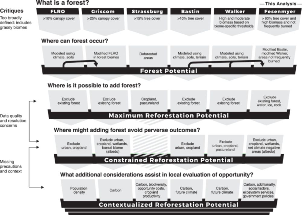
Addressing critiques refines global estimates of reforestation potential for climate change mitigation - Nature Communications
Reforestation is a key climate change mitigation strategy, but global maps of its potential are widely criticized. This study shows that addressing those critiques substantially refines estimates of t...
www.nature.com
June 23, 2025 at 5:45 PM
A couple years ago, I was approached by some scientists at The Nature Conservancy with a proposal: Would I help them create a better global restoration opportunity map? The resulting paper is now out, and I will explain my view of it in this thread. www.nature.com/articles/s41...
Takes one to know one.
(But this guy isn’t one)
(But this guy isn’t one)

Obviously a lie, since the definition of PhD-level expertise, standard across universities worldwide, is that you can produce original knowledge.
OpenAI claims new GPT-5 model boosts ChatGPT to ‘PhD level’
GPT-5's release comes as tech firms continue to compete in an effort to claim the world's most advanced AI.
www.bbc.co.uk
August 8, 2025 at 2:09 PM
Takes one to know one.
(But this guy isn’t one)
(But this guy isn’t one)
Reposted by shishir


Reposted by shishir
'Plastics are a grave, growing, and under-recognised danger to human and planetary health. Plastics cause disease and death from infancy to old age and are responsible for health-related economic losses exceeding US$1·5 trillion annually.'
www.thelancet.com/journals/lan...
www.thelancet.com/journals/lan...
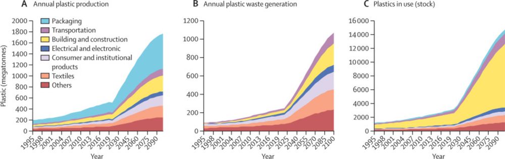
The Lancet Countdown on health and plastics
Plastics are a grave, growing, and under-recognised danger to human and planetary
health. Plastics cause disease and death from infancy to old age and are responsible
for health-related economic losse...
www.thelancet.com
August 4, 2025 at 8:45 AM
'Plastics are a grave, growing, and under-recognised danger to human and planetary health. Plastics cause disease and death from infancy to old age and are responsible for health-related economic losses exceeding US$1·5 trillion annually.'
www.thelancet.com/journals/lan...
www.thelancet.com/journals/lan...
Reposted by shishir
🔥 New in IJWF:
How will climate change reshape fuel hazards across landscapes?
McColl-Gausden et al. modelled future fire risks across Victoria, Australia and their findings highlight the urgent need for adaptive fuel management in a warming climate.
📖 Read: doi.org/10.1071/WF24...
#IJWildlandFire
How will climate change reshape fuel hazards across landscapes?
McColl-Gausden et al. modelled future fire risks across Victoria, Australia and their findings highlight the urgent need for adaptive fuel management in a warming climate.
📖 Read: doi.org/10.1071/WF24...
#IJWildlandFire
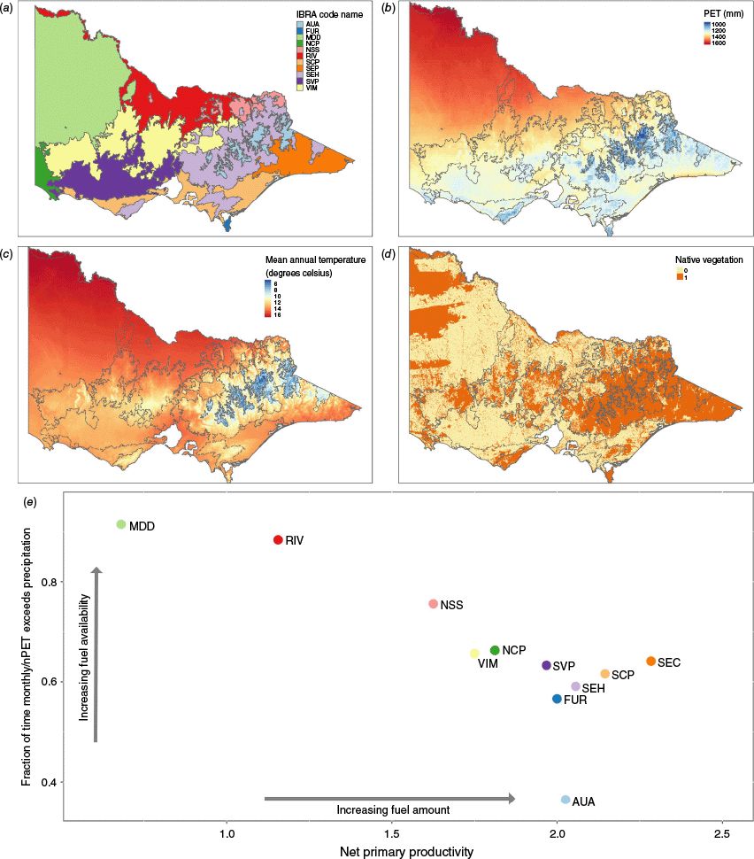
June 26, 2025 at 12:10 PM
🔥 New in IJWF:
How will climate change reshape fuel hazards across landscapes?
McColl-Gausden et al. modelled future fire risks across Victoria, Australia and their findings highlight the urgent need for adaptive fuel management in a warming climate.
📖 Read: doi.org/10.1071/WF24...
#IJWildlandFire
How will climate change reshape fuel hazards across landscapes?
McColl-Gausden et al. modelled future fire risks across Victoria, Australia and their findings highlight the urgent need for adaptive fuel management in a warming climate.
📖 Read: doi.org/10.1071/WF24...
#IJWildlandFire
Reposted by shishir

Interesting:
"Needleleaf evergreen iWUE increased until circa 2002 before declining in recent years, while iWUE of broadleaf deciduous species continued to increase."
"Needleleaf evergreen iWUE increased until circa 2002 before declining in recent years, while iWUE of broadleaf deciduous species continued to increase."
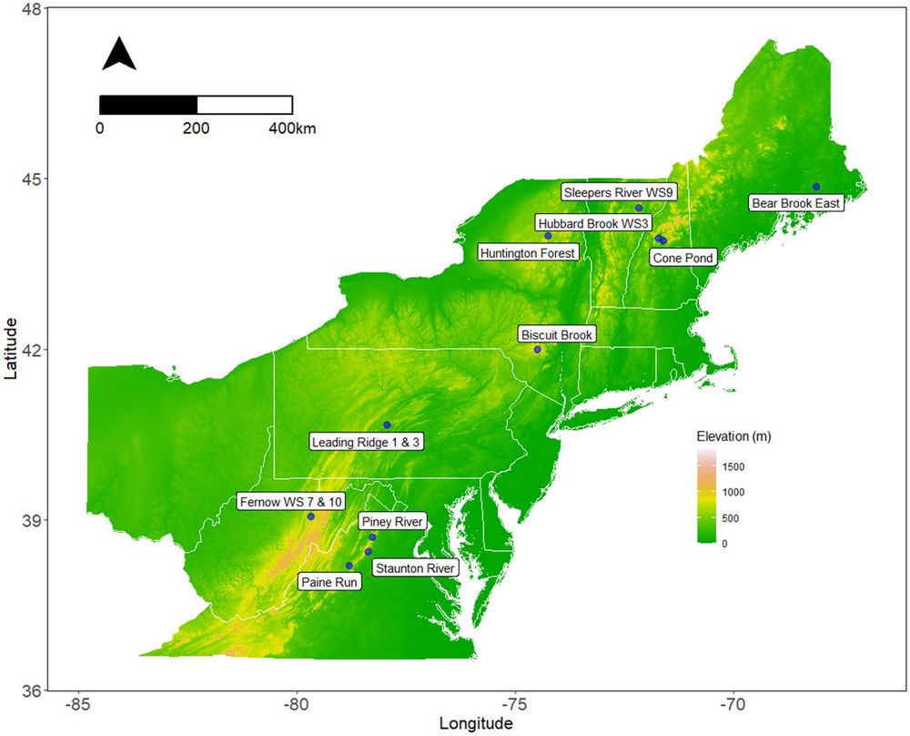
Divergent water use efficiency trends among eastern North American temperate tree species - Oecologia
Both theory and observations suggest that tree intrinsic water use efficiency (iWUE)—the ratio of photosynthetic carbon assimilation to stomatal conductance to water—increases with atmospheric CO2. Ho...
link.springer.com
August 3, 2025 at 2:48 PM
Interesting:
"Needleleaf evergreen iWUE increased until circa 2002 before declining in recent years, while iWUE of broadleaf deciduous species continued to increase."
"Needleleaf evergreen iWUE increased until circa 2002 before declining in recent years, while iWUE of broadleaf deciduous species continued to increase."
Even more so, dehumidifiers remain underappreciated. Some portable ACs come with the dehumidifier setting, and you can cut down your energy consumption by ~1/3rd without accounting for the reduced need for cooling (because most of our discomfort is from the humidity).
August 3, 2025 at 3:45 AM
Even more so, dehumidifiers remain underappreciated. Some portable ACs come with the dehumidifier setting, and you can cut down your energy consumption by ~1/3rd without accounting for the reduced need for cooling (because most of our discomfort is from the humidity).
Reposted by shishir

DuckDuckGo has added a feature to filter out AI images from search results.

August 2, 2025 at 8:00 PM
DuckDuckGo has added a feature to filter out AI images from search results.
“If you want to save the world then the first step is to stop destroying it. In other words: don’t be a dick. Don’t work for big tech, arms manufacturers or the fossil fuel industry. Don’t accept relationships based on domination and share power whenever you can.”

‘Self-termination is most likely’: the history and future of societal collapse
An epic analysis of 5,000 years of civilisation argues that a global collapse is coming unless inequality is vanquished
www.theguardian.com
August 2, 2025 at 3:41 PM
“If you want to save the world then the first step is to stop destroying it. In other words: don’t be a dick. Don’t work for big tech, arms manufacturers or the fossil fuel industry. Don’t accept relationships based on domination and share power whenever you can.”
Reposted by shishir

After a long absence from Twitter, I'm now on Bluesky. Looking forward to sharing thoughts, research, and rants about the lack of attention paid to water. Let's kick this off with a new paper alert. Please share widely. Title says it all. Please help me grow followers www.science.org/doi/10.1126/...
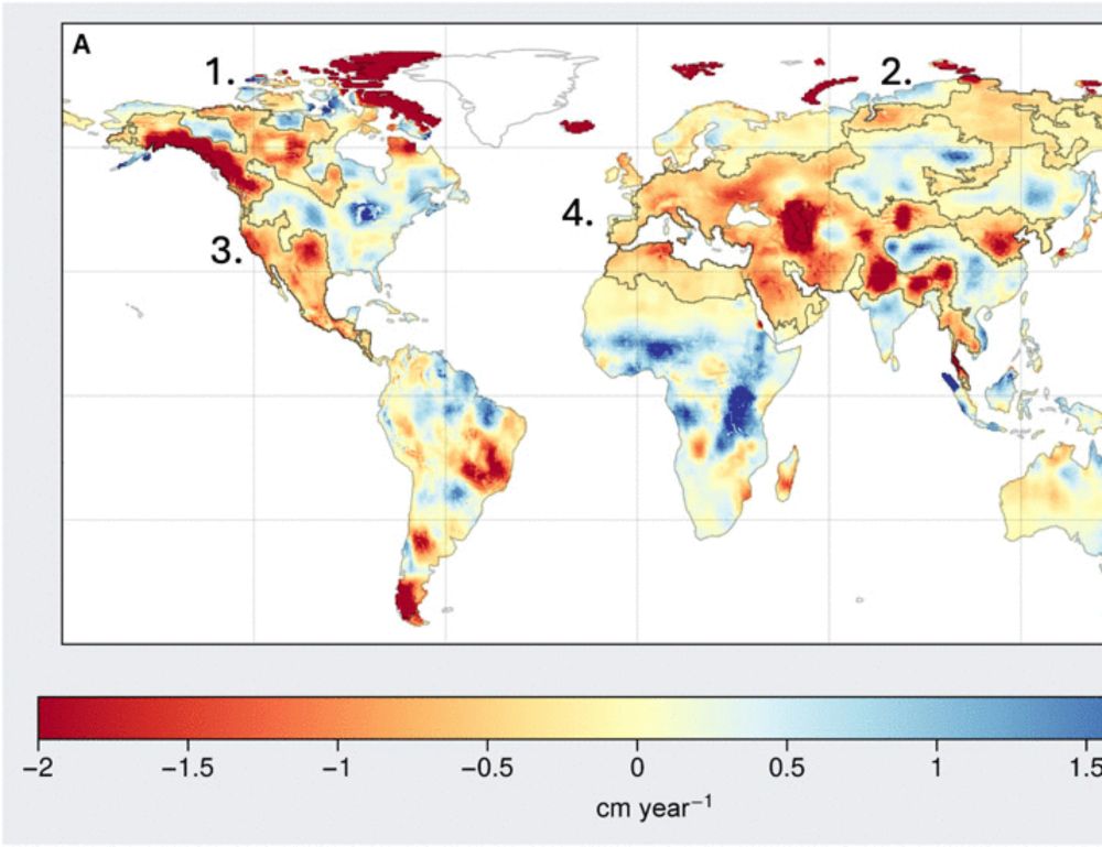
Unprecedented continental drying, shrinking freshwater availability, and increasing land contributions to sea level rise
Drying continents, extreme drought, and groundwater depletion are shrinking water availability and increasing sea level rise.
www.science.org
July 26, 2025 at 2:13 AM
After a long absence from Twitter, I'm now on Bluesky. Looking forward to sharing thoughts, research, and rants about the lack of attention paid to water. Let's kick this off with a new paper alert. Please share widely. Title says it all. Please help me grow followers www.science.org/doi/10.1126/...
Reposted by shishir

Three years ago, Pakistan faced a summer of deadly torrential rains that led to widespread flooding, impacting over 30 million people, thousands lost their lives. News reports quickly linked the disaster to climate change, highlighting the clear human impact and seemingly straightforward science.
July 26, 2025 at 5:46 PM
Three years ago, Pakistan faced a summer of deadly torrential rains that led to widespread flooding, impacting over 30 million people, thousands lost their lives. News reports quickly linked the disaster to climate change, highlighting the clear human impact and seemingly straightforward science.
Reposted by shishir
When I toured the Valley w/ @figlatin.bsky.social & @fkearns.bsky.social to learn more for my book, I saw this & was thunderstruck. We passed a normal-looking standpipe, the top level w/our heads. Another knowledgeable person we were with, Megan, said, "The top of this used to be level w/the ground"
You may not feel it, but the ground beneath you may be sinking.
In fact, the surface of California’s Central Valley is nearly 30 vertical feet lower than it was a century ago.
Why is this happening? Because our planet is rapidly drying. THREAD/
In fact, the surface of California’s Central Valley is nearly 30 vertical feet lower than it was a century ago.
Why is this happening? Because our planet is rapidly drying. THREAD/
July 26, 2025 at 2:24 PM
When I toured the Valley w/ @figlatin.bsky.social & @fkearns.bsky.social to learn more for my book, I saw this & was thunderstruck. We passed a normal-looking standpipe, the top level w/our heads. Another knowledgeable person we were with, Megan, said, "The top of this used to be level w/the ground"
Reposted by shishir

Every time I open LinkedIn, someone from a science agency shares an unplanned (forced) early retirement or RIF. Lately it’s NASA & EPA. In spring, NOAA. I think people have no idea how deep this loss really is. I don’t know what rebuilding federal science looks like, but it won’t be simple or quick.
July 26, 2025 at 1:19 PM
Every time I open LinkedIn, someone from a science agency shares an unplanned (forced) early retirement or RIF. Lately it’s NASA & EPA. In spring, NOAA. I think people have no idea how deep this loss really is. I don’t know what rebuilding federal science looks like, but it won’t be simple or quick.
Reposted by shishir

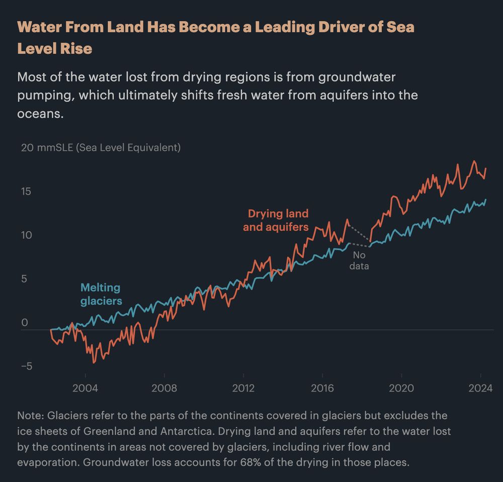
7/ It’s not just about losing usable water, either. According to a new study based on 20+ years of NASA data, runoff from pumped groundwater, combined with moisture lost to evaporation and drought, is now one of the largest contributors of sea level rise.
July 26, 2025 at 2:04 PM
7/ It’s not just about losing usable water, either. According to a new study based on 20+ years of NASA data, runoff from pumped groundwater, combined with moisture lost to evaporation and drought, is now one of the largest contributors of sea level rise.
Reposted by shishir
4/ Globally, 70% of fresh water is used for growing crops, with more of it coming from groundwater as droughts become more extreme. But only a small amount of that water makes its way back into aquifers.

July 26, 2025 at 1:56 PM
4/ Globally, 70% of fresh water is used for growing crops, with more of it coming from groundwater as droughts become more extreme. But only a small amount of that water makes its way back into aquifers.
Reposted by shishir

For some reason it bothers me a lot that this doesn't acknowledge that this graphic is a remake of two sets of very important USGS historical photos documenting & visualizing land subsidence from groundwater withdrawals in CA's Central Valley.
Yes, the USGS work is public domain, but still.
Yes, the USGS work is public domain, but still.
You may not feel it, but the ground beneath you may be sinking.
In fact, the surface of California’s Central Valley is nearly 30 vertical feet lower than it was a century ago.
Why is this happening? Because our planet is rapidly drying. THREAD/
In fact, the surface of California’s Central Valley is nearly 30 vertical feet lower than it was a century ago.
Why is this happening? Because our planet is rapidly drying. THREAD/
July 26, 2025 at 3:10 PM
For some reason it bothers me a lot that this doesn't acknowledge that this graphic is a remake of two sets of very important USGS historical photos documenting & visualizing land subsidence from groundwater withdrawals in CA's Central Valley.
Yes, the USGS work is public domain, but still.
Yes, the USGS work is public domain, but still.
Reposted by shishir

Google's AI summaries are
- killing traffic to legitimate sites
- producing summaries that can be wrong
- in the long run probably making you a dumbass
www.404media.co/googles-ai-i...
- killing traffic to legitimate sites
- producing summaries that can be wrong
- in the long run probably making you a dumbass
www.404media.co/googles-ai-i...

Google’s AI Is Destroying Search, the Internet, and Your Brain
Google’s AI Overview, which is easy to fool into stating nonsense as fact, is stopping people from finding and supporting small businesses and credible sources.
www.404media.co
July 23, 2025 at 7:11 PM
Google's AI summaries are
- killing traffic to legitimate sites
- producing summaries that can be wrong
- in the long run probably making you a dumbass
www.404media.co/googles-ai-i...
- killing traffic to legitimate sites
- producing summaries that can be wrong
- in the long run probably making you a dumbass
www.404media.co/googles-ai-i...
Reposted by shishir
Wind and frost have surprisingly strong effects on global patterns in leaf cuticle thickness! Latitude, biome and taxonomy matter too. Other climate variables not so much. #trait research from international team including @lawrensack.bsky.social @westobymark.bsky.social. doi.org/10.1111/nph....

July 21, 2025 at 12:00 PM
Wind and frost have surprisingly strong effects on global patterns in leaf cuticle thickness! Latitude, biome and taxonomy matter too. Other climate variables not so much. #trait research from international team including @lawrensack.bsky.social @westobymark.bsky.social. doi.org/10.1111/nph....
Reposted by shishir

🚨New report on science under coercion in India.
Scientists and researchers assessing environmental and biodiversity impacts for Rs. 81,000 crore Great Nicobar mega project worked under immense institutional pressure and gag orders to provide favourable reports
article-14.com/post/how-sci...
Scientists and researchers assessing environmental and biodiversity impacts for Rs. 81,000 crore Great Nicobar mega project worked under immense institutional pressure and gag orders to provide favourable reports
article-14.com/post/how-sci...

How Scientists Were Coerced To Toe The Govt Line & Clear The Path To Destroy Great Nicobar’s Rainforest
India’s top wildlife and biodiversity institutes tasked with assessing the environmental impact of a Rs 81,000-crore project on the Great Nicobar Island worked under intense pressure to deliver report...
article-14.com
July 21, 2025 at 5:15 AM
🚨New report on science under coercion in India.
Scientists and researchers assessing environmental and biodiversity impacts for Rs. 81,000 crore Great Nicobar mega project worked under immense institutional pressure and gag orders to provide favourable reports
article-14.com/post/how-sci...
Scientists and researchers assessing environmental and biodiversity impacts for Rs. 81,000 crore Great Nicobar mega project worked under immense institutional pressure and gag orders to provide favourable reports
article-14.com/post/how-sci...
Reposted by shishir
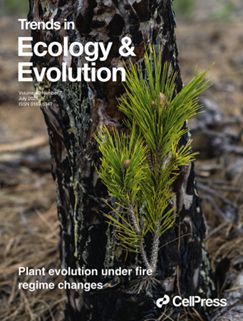
Can plants keep up with fire regime changes through evolution?
Our new paper is out in the July issue of @cp-trendsecolevo.bsky.social
📖 www.cell.com/trends/ecolo...
with Hoffmann, Nitschke & @jgpausas.bsky.social
#fireecology #PlantBiology #ecoevo 🔥🌿🧬
Our new paper is out in the July issue of @cp-trendsecolevo.bsky.social
📖 www.cell.com/trends/ecolo...
with Hoffmann, Nitschke & @jgpausas.bsky.social
#fireecology #PlantBiology #ecoevo 🔥🌿🧬
July 22, 2025 at 7:48 AM
Can plants keep up with fire regime changes through evolution?
Our new paper is out in the July issue of @cp-trendsecolevo.bsky.social
📖 www.cell.com/trends/ecolo...
with Hoffmann, Nitschke & @jgpausas.bsky.social
#fireecology #PlantBiology #ecoevo 🔥🌿🧬
Our new paper is out in the July issue of @cp-trendsecolevo.bsky.social
📖 www.cell.com/trends/ecolo...
with Hoffmann, Nitschke & @jgpausas.bsky.social
#fireecology #PlantBiology #ecoevo 🔥🌿🧬