


Claudio Satriano
@claudio.seismicsource.org
Reposted by Claudio Satriano

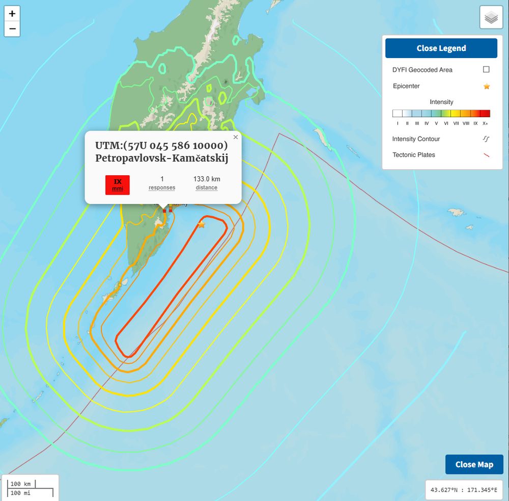
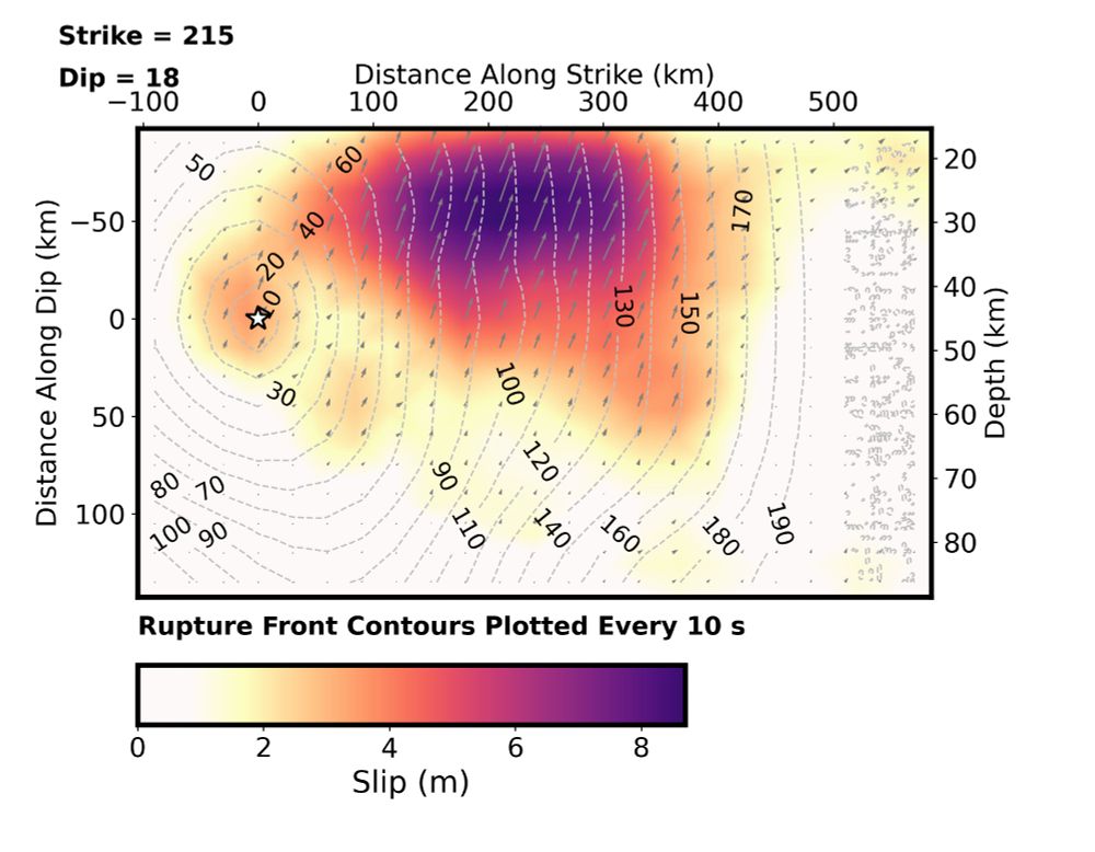
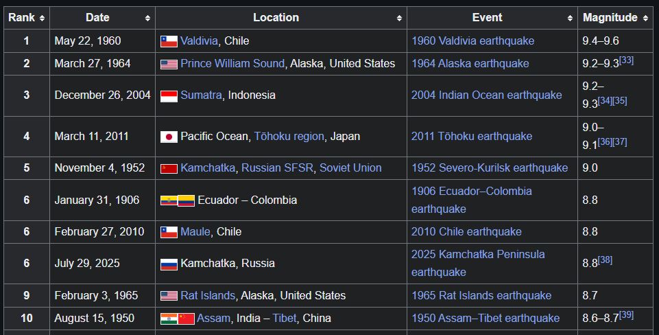
#EarthquakeReport for M8.8 #Earthquake offshore of #Kamchatka #Russia
tied 8th largest magnitude temblor instrumentally recorded
@USGS_Quakes finite fault slip model 8+ meters slip
similar to 1952 M9
learn about tectonics here: earthjay.com?p=12053
earthquake.usgs.gov/earthquakes/...
tied 8th largest magnitude temblor instrumentally recorded
@USGS_Quakes finite fault slip model 8+ meters slip
similar to 1952 M9
learn about tectonics here: earthjay.com?p=12053
earthquake.usgs.gov/earthquakes/...
July 30, 2025 at 8:56 AM
#EarthquakeReport for M8.8 #Earthquake offshore of #Kamchatka #Russia
tied 8th largest magnitude temblor instrumentally recorded
@USGS_Quakes finite fault slip model 8+ meters slip
similar to 1952 M9
learn about tectonics here: earthjay.com?p=12053
earthquake.usgs.gov/earthquakes/...
tied 8th largest magnitude temblor instrumentally recorded
@USGS_Quakes finite fault slip model 8+ meters slip
similar to 1952 M9
learn about tectonics here: earthjay.com?p=12053
earthquake.usgs.gov/earthquakes/...
Reposted by Claudio Satriano
Pyroclastic flows at Etna have been confirmed by INGV ⚒️🌋

June 2, 2025 at 9:56 AM
Pyroclastic flows at Etna have been confirmed by INGV ⚒️🌋
Reposted by Claudio Satriano

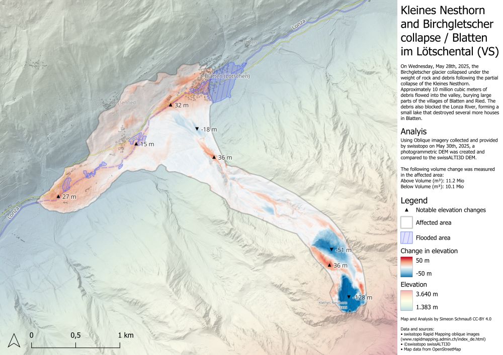
I also derived a new elevation model from the aerial images, allowing me to visualize the elevation change in the affected areas.
The rocks and debris in the valley are locally up to 32m thick and I estimate the total displaced volume is about 11 million cubic meters. #Blatten
The rocks and debris in the valley are locally up to 32m thick and I estimate the total displaced volume is about 11 million cubic meters. #Blatten
June 1, 2025 at 9:39 AM
I also derived a new elevation model from the aerial images, allowing me to visualize the elevation change in the affected areas.
The rocks and debris in the valley are locally up to 32m thick and I estimate the total displaced volume is about 11 million cubic meters. #Blatten
The rocks and debris in the valley are locally up to 32m thick and I estimate the total displaced volume is about 11 million cubic meters. #Blatten
Reposted by Claudio Satriano

"we explain the ”unusual” waveform signature of the Myanmar earthquake by a multiple, asymmetric bilateral rupture, involving boomerang-like back-rupture propagation and supershear." Preprint by Inoue, et al. about the Myanmar quake eartharxiv.org/repository/v... ⚒️🧪
A multiple asymmetric bilateral rupture sequence derived from the peculiar tele-seismic P-waves of the 2025 Myanmar earthquake
eartharxiv.org
April 13, 2025 at 12:48 PM
"we explain the ”unusual” waveform signature of the Myanmar earthquake by a multiple, asymmetric bilateral rupture, involving boomerang-like back-rupture propagation and supershear." Preprint by Inoue, et al. about the Myanmar quake eartharxiv.org/repository/v... ⚒️🧪
Reposted by Claudio Satriano

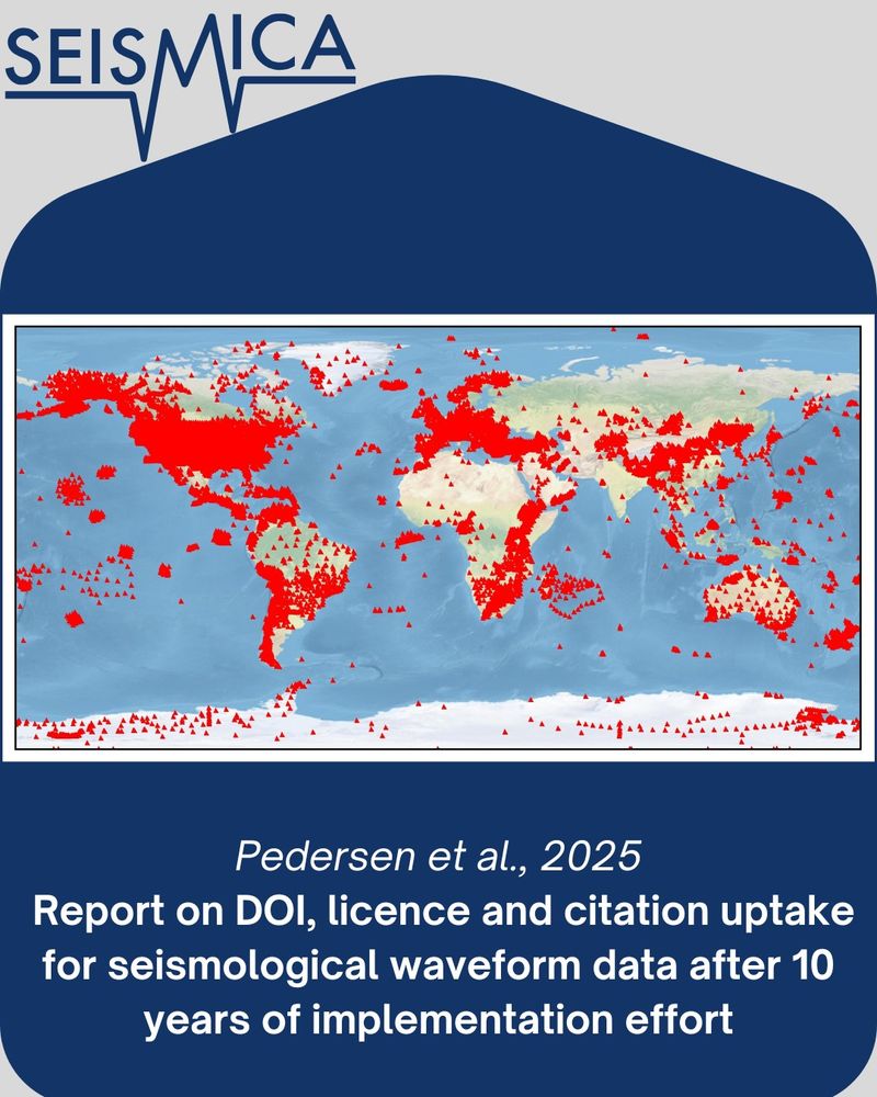
Achieving Success in Seismic Network DOIs for data sharing and attribution!
The seismological community strategy is a success, citations improved and licensing is starting. In this paper Pedersen et al., propose recommendations for the way forward
Read now: seismica.library.mcgill.ca/article/view...
The seismological community strategy is a success, citations improved and licensing is starting. In this paper Pedersen et al., propose recommendations for the way forward
Read now: seismica.library.mcgill.ca/article/view...
April 2, 2025 at 12:13 AM
Achieving Success in Seismic Network DOIs for data sharing and attribution!
The seismological community strategy is a success, citations improved and licensing is starting. In this paper Pedersen et al., propose recommendations for the way forward
Read now: seismica.library.mcgill.ca/article/view...
The seismological community strategy is a success, citations improved and licensing is starting. In this paper Pedersen et al., propose recommendations for the way forward
Read now: seismica.library.mcgill.ca/article/view...
Reposted by Claudio Satriano

NASA JPL ARIA project analysis of data from Copernicus Sentinel-2 optical and Sentinel-1 radar images measured the slip on the Sagaing Fault in Myanmar. Quick preliminary map. More details later. Fault ruptured about 500 km (300 miles) in the magnitude 7.7 […]
[Original post on mastodon.social]
[Original post on mastodon.social]

April 1, 2025 at 6:36 PM
NASA JPL ARIA project analysis of data from Copernicus Sentinel-2 optical and Sentinel-1 radar images measured the slip on the Sagaing Fault in Myanmar. Quick preliminary map. More details later. Fault ruptured about 500 km (300 miles) in the magnitude 7.7 […]
[Original post on mastodon.social]
[Original post on mastodon.social]
Reposted by Claudio Satriano
Very (very) rough analysis indicates >6 m of slip.
I resolve pixel offset using DIC in experimental cm sized samples with speckle pattern, and never used it before on satellite images. However the dextral offset is pretty clear, and I trust my calibration so the slip magnitude should be about right.
I resolve pixel offset using DIC in experimental cm sized samples with speckle pattern, and never used it before on satellite images. However the dextral offset is pretty clear, and I trust my calibration so the slip magnitude should be about right.

March 30, 2025 at 8:45 PM
Very (very) rough analysis indicates >6 m of slip.
I resolve pixel offset using DIC in experimental cm sized samples with speckle pattern, and never used it before on satellite images. However the dextral offset is pretty clear, and I trust my calibration so the slip magnitude should be about right.
I resolve pixel offset using DIC in experimental cm sized samples with speckle pattern, and never used it before on satellite images. However the dextral offset is pretty clear, and I trust my calibration so the slip magnitude should be about right.
Reposted by Claudio Satriano

First Satellite Images from Myanmar are available. Surface Deformation along the Sagaing Fault and the collapsed Ava.Bridge are visible in Downtown Sagaing. Pictures and Videos from the Surface Rupture have been reported since Friday.
Via browser.dataspace.copernicus.eu
#Myanmar #Earthquake
Via browser.dataspace.copernicus.eu
#Myanmar #Earthquake
March 30, 2025 at 10:13 AM
First Satellite Images from Myanmar are available. Surface Deformation along the Sagaing Fault and the collapsed Ava.Bridge are visible in Downtown Sagaing. Pictures and Videos from the Surface Rupture have been reported since Friday.
Via browser.dataspace.copernicus.eu
#Myanmar #Earthquake
Via browser.dataspace.copernicus.eu
#Myanmar #Earthquake
Reposted by Claudio Satriano

Mw=7.1, TONGA ISLANDS (Depth: 16 km), 2025/03/30 12:18:43 UTC - Full details here: http://geoscope.ipgp.fr/scripts/seismes/fiche.php?seis=us7000pntq

March 30, 2025 at 1:02 PM
Mw=7.1, TONGA ISLANDS (Depth: 16 km), 2025/03/30 12:18:43 UTC - Full details here: http://geoscope.ipgp.fr/scripts/seismes/fiche.php?seis=us7000pntq
Reposted by Claudio Satriano

The fault involved in the M7.7 earthquake in #Myanmar is well known but the #Mandalay area didn't show much seismic activity so far.

🔎 Regional instrumental seismicity in Myanmar. The colored dots represent the #earthquakes that have struck the region [using @ISCseism catalog -1960 to 2020- and @EMSC data -from 2021 onwards]:

March 28, 2025 at 8:09 AM
Reposted by Claudio Satriano

Looking at the historical earthquake map and the preliminary USGS slip model below, it seems today's large earthquake filled partly the gap between 20 and 22 degrees North latitude.

March 28, 2025 at 10:42 AM
Looking at the historical earthquake map and the preliminary USGS slip model below, it seems today's large earthquake filled partly the gap between 20 and 22 degrees North latitude.
Reposted by Claudio Satriano
Mw=7.9, MYANMAR (Depth: 35 km), 2025/03/28 06:20:54 UTC - Full details here: http://geoscope.ipgp.fr/scripts/seismes/fiche.php?seis=us7000pn9s

March 28, 2025 at 7:03 AM
Mw=7.9, MYANMAR (Depth: 35 km), 2025/03/28 06:20:54 UTC - Full details here: http://geoscope.ipgp.fr/scripts/seismes/fiche.php?seis=us7000pn9s
Reposted by Claudio Satriano

First slip map for the Mw 7.8 Myanmar earthquake. Propagation of rupture towards the South. Slipnear method (Géoazur/OCA).

March 28, 2025 at 8:17 AM
First slip map for the Mw 7.8 Myanmar earthquake. Propagation of rupture towards the South. Slipnear method (Géoazur/OCA).
Reposted by Claudio Satriano
Rapport scientifique et technique d'étape sur le séisme de magnitude 4.1 du 18 mars 2025 au nord de Nice, commune de Coaraze, et la séquence sismique qui a suivi.
sismoazur.oca.eu/static/doc/s...
sismoazur.oca.eu#/specific_re...
sismoazur.oca.eu/static/doc/s...
sismoazur.oca.eu#/specific_re...
Sismoazur
sismoazur.oca.eu
March 25, 2025 at 5:17 PM
Rapport scientifique et technique d'étape sur le séisme de magnitude 4.1 du 18 mars 2025 au nord de Nice, commune de Coaraze, et la séquence sismique qui a suivi.
sismoazur.oca.eu/static/doc/s...
sismoazur.oca.eu#/specific_re...
sismoazur.oca.eu/static/doc/s...
sismoazur.oca.eu#/specific_re...
Reposted by Claudio Satriano
Revised source inversions of the Ml4.1 and Ml3.8 shocks that occurred on March 18, 2025 just north of the city of Nice in southern France.


March 19, 2025 at 12:58 AM
Revised source inversions of the Ml4.1 and Ml3.8 shocks that occurred on March 18, 2025 just north of the city of Nice in southern France.
Reposted by Claudio Satriano
Mw=6.2, SOUTH OF PANAMA (Depth: 13 km), 2025/03/21 14:50:51 UTC - Full details here: http://geoscope.ipgp.fr/scripts/seismes/fiche.php?seis=us7000pllt

March 21, 2025 at 3:31 PM
Mw=6.2, SOUTH OF PANAMA (Depth: 13 km), 2025/03/21 14:50:51 UTC - Full details here: http://geoscope.ipgp.fr/scripts/seismes/fiche.php?seis=us7000pllt
Reposted by Claudio Satriano
#EarthquakeReport #TsunamiReport for #OTD in 2011 M9.1 #Earthquake offshore of #Japan
generated 50+m of megathrust fault slip
produced local and transpacific #Tsunami
learn more
earthjay.com?p=9773
and @calconservation.bsky.social @cageosurvey.bsky.social
storymaps.arcgis.com/stories/d230...
generated 50+m of megathrust fault slip
produced local and transpacific #Tsunami
learn more
earthjay.com?p=9773
and @calconservation.bsky.social @cageosurvey.bsky.social
storymaps.arcgis.com/stories/d230...

March 11, 2025 at 5:07 PM
#EarthquakeReport #TsunamiReport for #OTD in 2011 M9.1 #Earthquake offshore of #Japan
generated 50+m of megathrust fault slip
produced local and transpacific #Tsunami
learn more
earthjay.com?p=9773
and @calconservation.bsky.social @cageosurvey.bsky.social
storymaps.arcgis.com/stories/d230...
generated 50+m of megathrust fault slip
produced local and transpacific #Tsunami
learn more
earthjay.com?p=9773
and @calconservation.bsky.social @cageosurvey.bsky.social
storymaps.arcgis.com/stories/d230...
Reposted by Claudio Satriano

🌀 Les stations de l'OVPF-IPGP n'ont pas été épargnées par les vents cycloniques de #Garance: stations détruites, panneaux solaires brisés, antennes cassées, portes de coffret arrachées...
👨🔧Les équipes restent mobilisées pour remettre en état ce réseau et évacuer prochainement les stations détruites.
👨🔧Les équipes restent mobilisées pour remettre en état ce réseau et évacuer prochainement les stations détruites.


March 6, 2025 at 4:37 AM
🌀 Les stations de l'OVPF-IPGP n'ont pas été épargnées par les vents cycloniques de #Garance: stations détruites, panneaux solaires brisés, antennes cassées, portes de coffret arrachées...
👨🔧Les équipes restent mobilisées pour remettre en état ce réseau et évacuer prochainement les stations détruites.
👨🔧Les équipes restent mobilisées pour remettre en état ce réseau et évacuer prochainement les stations détruites.
Reposted by Claudio Satriano

And now for something completely different:
bsky.app/profile/wear...
bsky.app/profile/wear...
@alomaxnet.bsky.social (Lomax) uses aftershocks as virtual observations at the depth of rock deformation surrounding an earthquake rupture to image in 3D the fault slip during the earthquake.
Read more:
seismica.library.mcgill.ca/article/view...
Read more:
seismica.library.mcgill.ca/article/view...
March 4, 2025 at 2:12 PM
And now for something completely different:
bsky.app/profile/wear...
bsky.app/profile/wear...
Reposted by Claudio Satriano
@alomaxnet.bsky.social (Lomax) uses aftershocks as virtual observations at the depth of rock deformation surrounding an earthquake rupture to image in 3D the fault slip during the earthquake.
Read more:
seismica.library.mcgill.ca/article/view...
Read more:
seismica.library.mcgill.ca/article/view...
March 3, 2025 at 11:36 PM
@alomaxnet.bsky.social (Lomax) uses aftershocks as virtual observations at the depth of rock deformation surrounding an earthquake rupture to image in 3D the fault slip during the earthquake.
Read more:
seismica.library.mcgill.ca/article/view...
Read more:
seismica.library.mcgill.ca/article/view...
Reposted by Claudio Satriano
🌀Situation post-cyclone #Garance. Grâce à la forte mobilisation des équipes de l’OVPF-IPGP, l’observatoire a de nouveau le contact avec 65% de ses stations sur le terrain (contre 15% à la fin du cyclone).
L'OVPF-IPGP reste mobilisé pour remettre en état ce réseau le plus rapidement possible.
L'OVPF-IPGP reste mobilisé pour remettre en état ce réseau le plus rapidement possible.


March 3, 2025 at 12:44 PM
🌀Situation post-cyclone #Garance. Grâce à la forte mobilisation des équipes de l’OVPF-IPGP, l’observatoire a de nouveau le contact avec 65% de ses stations sur le terrain (contre 15% à la fin du cyclone).
L'OVPF-IPGP reste mobilisé pour remettre en état ce réseau le plus rapidement possible.
L'OVPF-IPGP reste mobilisé pour remettre en état ce réseau le plus rapidement possible.
Reposted by Claudio Satriano

Un séisme de magnitude 5.0)a été enregistré le dimanche 02 mars 2025 à 20:01 (heure locale) et identifié d'origine Tectonique. L'épicentre a été localisé à 57 km à l'est-nord-est de Trinité, à 46 km de profondeur.
Si vous avez ressenti ce séisme, merci de témoigner sur www.franceseisme.fr
Si vous avez ressenti ce séisme, merci de témoigner sur www.franceseisme.fr

March 3, 2025 at 12:35 AM
Un séisme de magnitude 5.0)a été enregistré le dimanche 02 mars 2025 à 20:01 (heure locale) et identifié d'origine Tectonique. L'épicentre a été localisé à 57 km à l'est-nord-est de Trinité, à 46 km de profondeur.
Si vous avez ressenti ce séisme, merci de témoigner sur www.franceseisme.fr
Si vous avez ressenti ce séisme, merci de témoigner sur www.franceseisme.fr
Reposted by Claudio Satriano

Reposted by Claudio Satriano
NLL-SSST-coherence high-precision earthquake location catalog for the 2025 #Santorini #Amorgos #earthquake swarm.
Based on data from Institute of Geodynamics of the National Observatory of Athens (NOA-IG).
Download & details: doi.org/10.5281/zeno...
Based on data from Institute of Geodynamics of the National Observatory of Athens (NOA-IG).
Download & details: doi.org/10.5281/zeno...
March 3, 2025 at 6:37 AM
NLL-SSST-coherence high-precision earthquake location catalog for the 2025 #Santorini #Amorgos #earthquake swarm.
Based on data from Institute of Geodynamics of the National Observatory of Athens (NOA-IG).
Download & details: doi.org/10.5281/zeno...
Based on data from Institute of Geodynamics of the National Observatory of Athens (NOA-IG).
Download & details: doi.org/10.5281/zeno...
Reposted by Claudio Satriano
Di Giacomo et al. had a fresh look at the time-dependent uncertainty related to early analog instrument picks. Their findings translate into a more reliable location uncertainty estimation. @iscseism.bsky.social
Read now: seismica.library.mcgill.ca/article/view...
Read now: seismica.library.mcgill.ca/article/view...

March 1, 2025 at 5:55 PM
Di Giacomo et al. had a fresh look at the time-dependent uncertainty related to early analog instrument picks. Their findings translate into a more reliable location uncertainty estimation. @iscseism.bsky.social
Read now: seismica.library.mcgill.ca/article/view...
Read now: seismica.library.mcgill.ca/article/view...