


Bertrand Delouis
@bertranddelouis.bsky.social
Seismologist. Geoazur lab.
Observatoire de la Côte d'Azur (OCA)
Université Côte D'Azur (UniCA)
France
Observatoire de la Côte d'Azur (OCA)
Université Côte D'Azur (UniCA)
France
Auto slipmap with regional records (SLIPNEAR method, Géoazur/OCA) M 6.0 - Western Turkey - 2025-10-27 19:48:28 (UTC) earthquake
Rupture plane not selected in an automated way. The two planes are shown.
The focal mechanism used is from GFZ
Rupture plane not selected in an automated way. The two planes are shown.
The focal mechanism used is from GFZ


October 28, 2025 at 7:32 AM
Auto slipmap with regional records (SLIPNEAR method, Géoazur/OCA) M 6.0 - Western Turkey - 2025-10-27 19:48:28 (UTC) earthquake
Rupture plane not selected in an automated way. The two planes are shown.
The focal mechanism used is from GFZ
Rupture plane not selected in an automated way. The two planes are shown.
The focal mechanism used is from GFZ
Auto slipmap with regional records (SLIPNEAR method, Géoazur/OCA) M 6.5 - E of Beauséjour, Guadeloupe - 2025-10-27 12:38:40 (UTC)
Rupture plane not selected in an automated way. The two planes are shown.
Rupture plane not selected in an automated way. The two planes are shown.


October 27, 2025 at 2:14 PM
Auto slipmap with regional records (SLIPNEAR method, Géoazur/OCA) M 6.5 - E of Beauséjour, Guadeloupe - 2025-10-27 12:38:40 (UTC)
Rupture plane not selected in an automated way. The two planes are shown.
Rupture plane not selected in an automated way. The two planes are shown.
Reposted by Bertrand Delouis

[Séisme ressenti]
Un séisme a été enregistré le lundi 27 octobre 2025 à 12:38 heure locale.
➡️ magnitude 6.6 ± 0.3
➡️ type Tectonique
👉Si vous l'avez ressenti, merci de nous aider en témoignant sur www.franceseisme.fr
Un séisme a été enregistré le lundi 27 octobre 2025 à 12:38 heure locale.
➡️ magnitude 6.6 ± 0.3
➡️ type Tectonique
👉Si vous l'avez ressenti, merci de nous aider en témoignant sur www.franceseisme.fr

October 27, 2025 at 1:33 PM
[Séisme ressenti]
Un séisme a été enregistré le lundi 27 octobre 2025 à 12:38 heure locale.
➡️ magnitude 6.6 ± 0.3
➡️ type Tectonique
👉Si vous l'avez ressenti, merci de nous aider en témoignant sur www.franceseisme.fr
Un séisme a été enregistré le lundi 27 octobre 2025 à 12:38 heure locale.
➡️ magnitude 6.6 ± 0.3
➡️ type Tectonique
👉Si vous l'avez ressenti, merci de nous aider en témoignant sur www.franceseisme.fr
Reposted by Bertrand Delouis

Mw=6.5, LEEWARD ISLANDS (Depth: 13 km), 2025/10/27 12:38:40 UTC - Full details here: http://geoscope.ipgp.fr/scripts/seismes/fiche.php?seis=us6000rjq8

October 27, 2025 at 1:20 PM
Mw=6.5, LEEWARD ISLANDS (Depth: 13 km), 2025/10/27 12:38:40 UTC - Full details here: http://geoscope.ipgp.fr/scripts/seismes/fiche.php?seis=us6000rjq8
Reposted by Bertrand Delouis

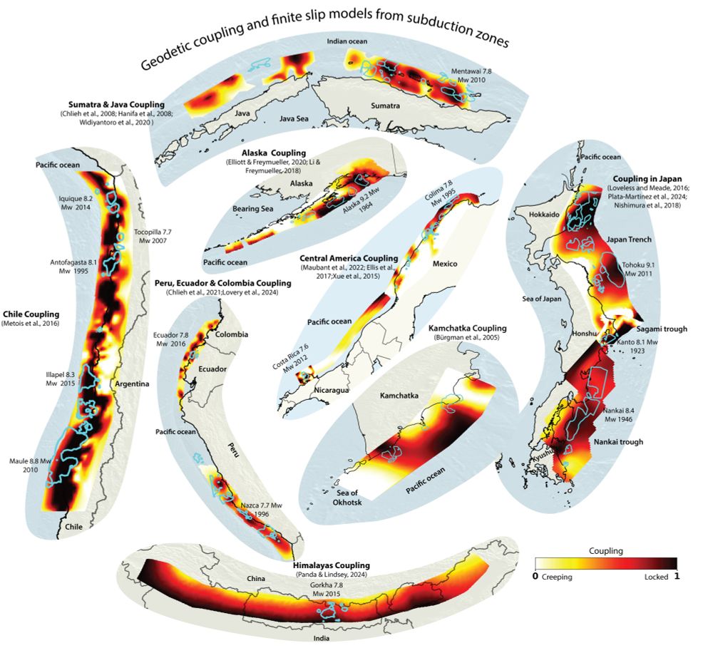
Do Coupled Megathrusts Rupture?
In our new preprint, Bar Oryan and I present
the first global analysis of the relationship between kinematic geodetic coupling and earthquake slip models across 12 subduction zones and 61 megathrust earthquakes.
eartharxiv.org/repository/v...
In our new preprint, Bar Oryan and I present
the first global analysis of the relationship between kinematic geodetic coupling and earthquake slip models across 12 subduction zones and 61 megathrust earthquakes.
eartharxiv.org/repository/v...
October 7, 2025 at 7:01 PM
Do Coupled Megathrusts Rupture?
In our new preprint, Bar Oryan and I present
the first global analysis of the relationship between kinematic geodetic coupling and earthquake slip models across 12 subduction zones and 61 megathrust earthquakes.
eartharxiv.org/repository/v...
In our new preprint, Bar Oryan and I present
the first global analysis of the relationship between kinematic geodetic coupling and earthquake slip models across 12 subduction zones and 61 megathrust earthquakes.
eartharxiv.org/repository/v...
Reposted by Bertrand Delouis

Our latest study in Nature, together with colleagues from @geomarkiel.bsky.social and universities from Greece, shows what happened beneath Santorini earlier this year when tens of thousands earthquakes shook the islands and the seafloor. It was magma. We also have 1/2
www.gfz.de/en/press/new...
www.gfz.de/en/press/new...

Magma displacement triggered tens of thousands of earthquakes
Magma displacement triggered tens of thousands of earthquakes: Analysis of the swarm of earthquakes around Santorini in early 2025 reveals causes and development of the seismic crisis
www.gfz.de
September 25, 2025 at 12:10 PM
Our latest study in Nature, together with colleagues from @geomarkiel.bsky.social and universities from Greece, shows what happened beneath Santorini earlier this year when tens of thousands earthquakes shook the islands and the seafloor. It was magma. We also have 1/2
www.gfz.de/en/press/new...
www.gfz.de/en/press/new...
Reposted by Bertrand Delouis

Quick map of M7.3 earthquake offshore the Alaska Peninsula. Today's earthquake (green) has a very similar focal mechanism to the M7.8 2020 Sand Point event, which was dominantly strike-slip but caused a tsunami. Based on depths of mainshock and early aftershocks, could be an upper plate event. ⚒️

July 16, 2025 at 9:56 PM
Quick map of M7.3 earthquake offshore the Alaska Peninsula. Today's earthquake (green) has a very similar focal mechanism to the M7.8 2020 Sand Point event, which was dominantly strike-slip but caused a tsunami. Based on depths of mainshock and early aftershocks, could be an upper plate event. ⚒️
Auto slipmap with regional records (SLIPNEAR method, Géoazur/OCA) M 7.3 - ALASKA - 2025-07-16 20:37:39 (UTC)
Plane striking N343 (NNW-SSE) shown.
Rupture direction to the South-East constrained by nearby stations (quite opposite to the USGS result).
Thanks to seismic records through IRIS
Plane striking N343 (NNW-SSE) shown.
Rupture direction to the South-East constrained by nearby stations (quite opposite to the USGS result).
Thanks to seismic records through IRIS

July 17, 2025 at 9:36 AM
Auto slipmap with regional records (SLIPNEAR method, Géoazur/OCA) M 7.3 - ALASKA - 2025-07-16 20:37:39 (UTC)
Plane striking N343 (NNW-SSE) shown.
Rupture direction to the South-East constrained by nearby stations (quite opposite to the USGS result).
Thanks to seismic records through IRIS
Plane striking N343 (NNW-SSE) shown.
Rupture direction to the South-East constrained by nearby stations (quite opposite to the USGS result).
Thanks to seismic records through IRIS
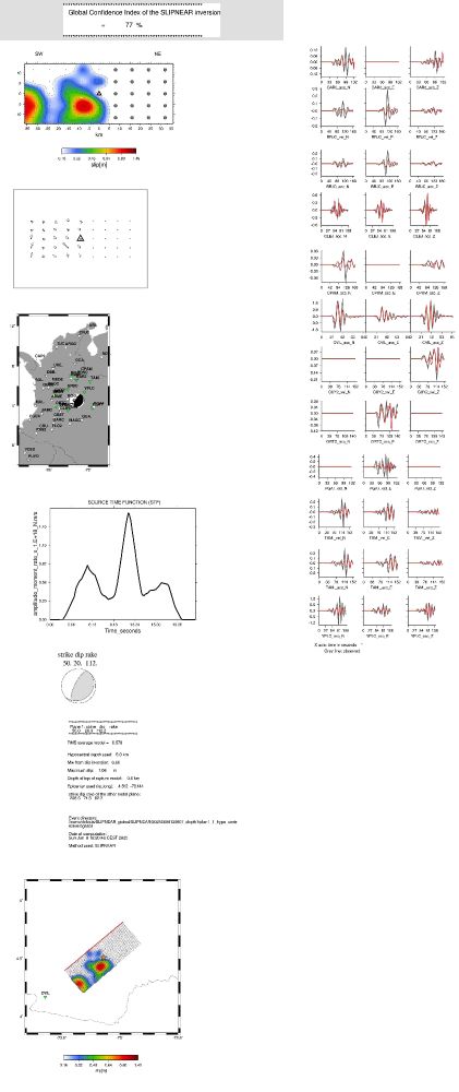
Slipmap for the earthquake of Colombia M6.4 of 8 June 2025. SLIPNEAR method.
Preferred rupture plane (strike,dip,rake) : 50 20 112
with confidence : 47.%
Discrimination among the two nodal planes
may be considered reliable only if
this confidence is larger or equal to 70%
Preferred rupture plane (strike,dip,rake) : 50 20 112
with confidence : 47.%
Discrimination among the two nodal planes
may be considered reliable only if
this confidence is larger or equal to 70%

June 8, 2025 at 2:53 PM
Slipmap for the earthquake of Colombia M6.4 of 8 June 2025. SLIPNEAR method.
Preferred rupture plane (strike,dip,rake) : 50 20 112
with confidence : 47.%
Discrimination among the two nodal planes
may be considered reliable only if
this confidence is larger or equal to 70%
Preferred rupture plane (strike,dip,rake) : 50 20 112
with confidence : 47.%
Discrimination among the two nodal planes
may be considered reliable only if
this confidence is larger or equal to 70%
Reposted by Bertrand Delouis

Our new study just out in #NatureCommunications maps the deep structure of Campi Flegrei with unprecedented detail—and found that pressurized fluids, not magma, are the main cause of current unrest 🇮🇹
Read the full study here:
🔗 doi.org/10.1038/s414...
Read the full study here:
🔗 doi.org/10.1038/s414...

3D structure and dynamics of Campi Flegrei enhance multi-hazard assessment - Nature Communications
This study maps Campi Flegrei caldera’s internal structure, linking a gas-enriched reservoir and a deformed caprock to ground uplift and earthquakes. Land instability, seismic events and the risk of a...
doi.org
May 23, 2025 at 11:20 PM
Our new study just out in #NatureCommunications maps the deep structure of Campi Flegrei with unprecedented detail—and found that pressurized fluids, not magma, are the main cause of current unrest 🇮🇹
Read the full study here:
🔗 doi.org/10.1038/s414...
Read the full study here:
🔗 doi.org/10.1038/s414...
Auto slipmap with regional records (SLIPNEAR method, Géoazur/OCA) M 7.5 – DRAKE PASSAGE 2025-05-02 12:58:27.5 UTC
Rupture plane not selected in an automated way. Plane dip to the NE (strike 326) shown.
Rupture propagation mainly to the SE.
Thanks to seismic records through IRIS
Rupture plane not selected in an automated way. Plane dip to the NE (strike 326) shown.
Rupture propagation mainly to the SE.
Thanks to seismic records through IRIS

May 2, 2025 at 5:57 PM
Auto slipmap with regional records (SLIPNEAR method, Géoazur/OCA) M 7.5 – DRAKE PASSAGE 2025-05-02 12:58:27.5 UTC
Rupture plane not selected in an automated way. Plane dip to the NE (strike 326) shown.
Rupture propagation mainly to the SE.
Thanks to seismic records through IRIS
Rupture plane not selected in an automated way. Plane dip to the NE (strike 326) shown.
Rupture propagation mainly to the SE.
Thanks to seismic records through IRIS
Reposted by Bertrand Delouis
Mw=6.2, NEAR COAST OF ECUADOR (Depth: 21 km), 2025/04/25 11:44:55 UTC - Full details here: http://geoscope.ipgp.fr/scripts/seismes/fiche.php?seis=us7000pv06

April 25, 2025 at 12:26 PM
Mw=6.2, NEAR COAST OF ECUADOR (Depth: 21 km), 2025/04/25 11:44:55 UTC - Full details here: http://geoscope.ipgp.fr/scripts/seismes/fiche.php?seis=us7000pv06
Reposted by Bertrand Delouis
Mw=6.3, TURKEY (Depth: 4 km), 2025/04/23 09:49:10 UTC - Full details here: http://geoscope.ipgp.fr/scripts/seismes/fiche.php?seis=us7000pufs

April 23, 2025 at 10:30 AM
Mw=6.3, TURKEY (Depth: 4 km), 2025/04/23 09:49:10 UTC - Full details here: http://geoscope.ipgp.fr/scripts/seismes/fiche.php?seis=us7000pufs
Auto slipmap with regional records (SLIPNEAR method, Géoazur/OCA) M 6.2 – Western Turkey - 2025-04-23 09:49:10 (UTC)
EW nodal plane preferred with confidence 65% as the rupture plane. Rupt propagation mainly to the East.
Thanks to seismic records from KOERI
EW nodal plane preferred with confidence 65% as the rupture plane. Rupt propagation mainly to the East.
Thanks to seismic records from KOERI

April 23, 2025 at 11:59 AM
Auto slipmap with regional records (SLIPNEAR method, Géoazur/OCA) M 6.2 – Western Turkey - 2025-04-23 09:49:10 (UTC)
EW nodal plane preferred with confidence 65% as the rupture plane. Rupt propagation mainly to the East.
Thanks to seismic records from KOERI
EW nodal plane preferred with confidence 65% as the rupture plane. Rupt propagation mainly to the East.
Thanks to seismic records from KOERI
Auto solution FMNEAR (Géoazur/OCA) with regional records for the M 5.2 – Southern California, 2025-04-14 17:08:28 UTC (Loc EMSC used to trigger inversion).
Thanks to the seismic records provided through IRIS and SCEDC
Thanks to the seismic records provided through IRIS and SCEDC

April 14, 2025 at 5:43 PM
Auto solution FMNEAR (Géoazur/OCA) with regional records for the M 5.2 – Southern California, 2025-04-14 17:08:28 UTC (Loc EMSC used to trigger inversion).
Thanks to the seismic records provided through IRIS and SCEDC
Thanks to the seismic records provided through IRIS and SCEDC
Reposted by Bertrand Delouis

The whole #MyanmarEarthquake rupture in one interferogram! This is three consecutive wide swath frames of ALOS-2 data, provided by JAXA through agreement with NASA. The line-of-sight (LOS) is ~perpendicular to fault strike, so most of what you see is vertical motion at bends and steps of the fault.

April 2, 2025 at 11:14 PM
The whole #MyanmarEarthquake rupture in one interferogram! This is three consecutive wide swath frames of ALOS-2 data, provided by JAXA through agreement with NASA. The line-of-sight (LOS) is ~perpendicular to fault strike, so most of what you see is vertical motion at bends and steps of the fault.
Reposted by Bertrand Delouis

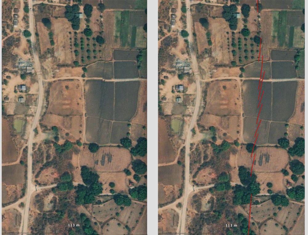
High resolution MAXAR satellite image reveals the #Myanmar #earthquake surface rupture north of the town of Sagaing. It is close to epicenter and N tip of the >400km long rupture.
Right-lateral offset of ~3.2m is clearly illustrated by the distorsion and lateral shift of a dirt road striking E-W.
Right-lateral offset of ~3.2m is clearly illustrated by the distorsion and lateral shift of a dirt road striking E-W.
April 2, 2025 at 8:07 AM
High resolution MAXAR satellite image reveals the #Myanmar #earthquake surface rupture north of the town of Sagaing. It is close to epicenter and N tip of the >400km long rupture.
Right-lateral offset of ~3.2m is clearly illustrated by the distorsion and lateral shift of a dirt road striking E-W.
Right-lateral offset of ~3.2m is clearly illustrated by the distorsion and lateral shift of a dirt road striking E-W.
Reposted by Bertrand Delouis

NASA JPL ARIA project analysis of data from Copernicus Sentinel-2 optical and Sentinel-1 radar images measured the slip on the Sagaing Fault in Myanmar. Quick preliminary map. More details later. Fault ruptured about 500 km (300 miles) in the magnitude 7.7 […]
[Original post on mastodon.social]
[Original post on mastodon.social]

April 1, 2025 at 6:36 PM
NASA JPL ARIA project analysis of data from Copernicus Sentinel-2 optical and Sentinel-1 radar images measured the slip on the Sagaing Fault in Myanmar. Quick preliminary map. More details later. Fault ruptured about 500 km (300 miles) in the magnitude 7.7 […]
[Original post on mastodon.social]
[Original post on mastodon.social]
Reposted by Bertrand Delouis

Remote surface rupture observations for the M7.7 2025 Myanmar earthquake - soft rollout!
doi.org/10.5066/P1RY...
Simple fault trace and slip distribution from pixel tracking, high-res from available imagery. Watch for updates!
⚒️ USGS and collaborators effort led by @nadinegrr.bsky.social 🙏
doi.org/10.5066/P1RY...
Simple fault trace and slip distribution from pixel tracking, high-res from available imagery. Watch for updates!
⚒️ USGS and collaborators effort led by @nadinegrr.bsky.social 🙏

April 1, 2025 at 10:46 PM
Remote surface rupture observations for the M7.7 2025 Myanmar earthquake - soft rollout!
doi.org/10.5066/P1RY...
Simple fault trace and slip distribution from pixel tracking, high-res from available imagery. Watch for updates!
⚒️ USGS and collaborators effort led by @nadinegrr.bsky.social 🙏
doi.org/10.5066/P1RY...
Simple fault trace and slip distribution from pixel tracking, high-res from available imagery. Watch for updates!
⚒️ USGS and collaborators effort led by @nadinegrr.bsky.social 🙏
Reposted by Bertrand Delouis


Reposted by Bertrand Delouis

The latest models from the USGS show slip, and associated strong shaking, extending much further to the south. Here I have plotted contours of estimated shaking over a map of population density. Note that the fault runs south through a narrow valley that is densely populated.
⚒️ 🧪 Myanmar earthquake
⚒️ 🧪 Myanmar earthquake

March 29, 2025 at 2:09 PM
The latest models from the USGS show slip, and associated strong shaking, extending much further to the south. Here I have plotted contours of estimated shaking over a map of population density. Note that the fault runs south through a narrow valley that is densely populated.
⚒️ 🧪 Myanmar earthquake
⚒️ 🧪 Myanmar earthquake
Reposted by Bertrand Delouis

Cross-section of slip distribution by the USGS for the M7.7 Myanmar earthquake. Slip occured along the distance of about 250 km, maximum ~horizontal slip of 5.1 meters. ⚒🧪

![Surface projection of the slip distribution superimposed on GEBCO bathymetry. Thick white lines indicate major plate boundaries [Bird, 2003]. Gray circles, if present, are aftershock locations, sized by magnitude.](https://cdn.bsky.app/img/feed_thumbnail/plain/did:plc:ypwk3a2va4sjhf635v2buswn/bafkreihu5hte2fh2rhq4raxjk3p4y6npgvjdfvnqj5rxeqxafx5tdsxjwa@jpeg)
March 28, 2025 at 9:32 AM
Cross-section of slip distribution by the USGS for the M7.7 Myanmar earthquake. Slip occured along the distance of about 250 km, maximum ~horizontal slip of 5.1 meters. ⚒🧪
Reposted by Bertrand Delouis

Looking at the historical earthquake map and the preliminary USGS slip model below, it seems today's large earthquake filled partly the gap between 20 and 22 degrees North latitude.

March 28, 2025 at 10:42 AM
Looking at the historical earthquake map and the preliminary USGS slip model below, it seems today's large earthquake filled partly the gap between 20 and 22 degrees North latitude.
Reposted by Bertrand Delouis

Preliminary back-projection which seems to confirm the finite fault model: www.linkedin.com/posts/hongju...

For the M7.7 Myanmar earthquake occurred in 28 March 2025, we produced the… | Hongjun Si
For the M7.7 Myanmar earthquake occurred in 28 March 2025, we produced the following analysis results for emergency response:
(1)Energy radiation from the…
www.linkedin.com
March 28, 2025 at 12:39 PM
Preliminary back-projection which seems to confirm the finite fault model: www.linkedin.com/posts/hongju...
First slip map for the Mw 7.8 Myanmar earthquake. Propagation of rupture towards the South. Slipnear method (Géoazur/OCA).

March 28, 2025 at 8:17 AM
First slip map for the Mw 7.8 Myanmar earthquake. Propagation of rupture towards the South. Slipnear method (Géoazur/OCA).